La haute vallée de la Saine - DREAL Franche-Comté
La haute vallée de la Saine - DREAL Franche-Comté
La haute vallée de la Saine - DREAL Franche-Comté

You also want an ePaper? Increase the reach of your titles
YUMPU automatically turns print PDFs into web optimized ePapers that Google loves.
Tableau d’assemb<strong>la</strong>ge<br />
<strong>La</strong> limite sud-est <strong>de</strong> <strong>la</strong> section B6 jusqu’à<br />
l’ancienne route <strong>de</strong>s P<strong>la</strong>nches à Foncine.<br />
L’ancienne route <strong>de</strong>s P<strong>la</strong>nches à Foncine.<br />
Commune <strong>de</strong>s P<strong>la</strong>nches-en-Montagne<br />
<strong>La</strong> traversée <strong>de</strong> <strong>la</strong> rue du Paradis jusqu’à l’angle<br />
nord <strong>de</strong> <strong>la</strong> parcelle 109.<br />
Tableau d’assemb<strong>la</strong>ge<br />
Les limites ouest <strong>de</strong> <strong>la</strong> section A4, sud-ouest <strong>de</strong> <strong>la</strong><br />
section A3 jusqu’à <strong>la</strong> RD n° 127.<br />
Section B1<br />
Le chemin <strong>de</strong>s Casca<strong>de</strong>s.<br />
<strong>La</strong> traversée <strong>de</strong> <strong>la</strong> rue <strong>de</strong> <strong>la</strong> <strong>La</strong>ngouette.<br />
<strong>La</strong> limite ouest du lieu-dit « Sur <strong>la</strong> <strong>La</strong>ngouette ».<br />
Section B7<br />
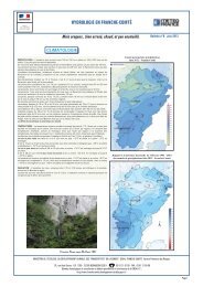
<strong>La</strong> <strong>haute</strong> <strong>vallée</strong> <strong>de</strong> <strong>la</strong> <strong>Saine</strong><br />
Section B2<br />
Le bief du <strong>La</strong>c jusqu’à l’angle sud-est <strong>de</strong> <strong>la</strong><br />
L’ancienne route <strong>de</strong>s P<strong>la</strong>nches à Foncine jusqu’à<br />
Section A5<br />
parcelle n° 248.<br />
l’angle ouest du lieu-dit « À <strong>la</strong> Millière ».<br />
<strong>La</strong> Gran<strong>de</strong>-Rue jusqu’à l’angle est <strong>de</strong> <strong>la</strong> parcelle<br />
Les limites sud et ouest <strong>de</strong> <strong>la</strong> parcelle n° 248.<br />
<strong>La</strong> limite ouest <strong>de</strong>s lieux-dits « À <strong>la</strong> Millière » et<br />
n° 297a.<br />
Le chemin <strong>de</strong> <strong>la</strong> Montagne ron<strong>de</strong> jusqu’à l’angle<br />
« Sur chez Girrod ».<br />
<strong>La</strong> limite sud-est <strong>de</strong> <strong>la</strong> parcelle n° 297a.<br />
sud du lieu-dit « Les Culottes ».<br />
<strong>La</strong> limite ouest <strong>de</strong> <strong>la</strong> parcelle n° 383 jusqu’à <strong>la</strong><br />
De l’angle sud <strong>de</strong> <strong>la</strong> parcelle n° 297a à l’angle<br />
<strong>La</strong> limite ouest du lieu-dit « Les Culottes ».<br />
<strong>Saine</strong>.<br />
nord-est <strong>de</strong> <strong>la</strong> parcelle n° 378a, une ligne fictive.<br />
<strong>La</strong> rive sud <strong>de</strong> <strong>la</strong> rivière jusqu’à <strong>la</strong> passerelle.<br />
<strong>La</strong> limite nord-est <strong>de</strong>s parcelles n° 378 a et 380a.<br />
Section B8<br />
<strong>La</strong> limite sud <strong>de</strong> <strong>la</strong> parcelle n° 380a.<br />
<strong>La</strong> limite sud <strong>de</strong> <strong>la</strong> parcelle n° 436c jusqu’à<br />
Section A5<br />
<strong>La</strong> limite nord-est <strong>de</strong> <strong>la</strong> parcelle n° 262b.<br />
l’angle sud-est <strong>de</strong> <strong>la</strong> parcelle n° 436b.<br />
<strong>La</strong> traversée <strong>de</strong> <strong>la</strong> rivière.<br />
<strong>La</strong> limite est <strong>de</strong>s parcelles 189, 227 et 176.<br />
De ce point, une ligne fictive qui rejoint le point<br />
<strong>La</strong> rive nord <strong>de</strong> <strong>la</strong> rivière jusqu’à l’angle sud-<br />
<strong>La</strong> rivière <strong>Saine</strong> jusqu’à l’angle nord-est <strong>de</strong> <strong>la</strong><br />
<strong>de</strong> rencontre <strong>de</strong> <strong>la</strong> parcelle 287 et <strong>de</strong> <strong>la</strong> limite<br />
ouest <strong>de</strong> <strong>la</strong> parcelle n° 121.<br />
parcelle n° 286.<br />
communale <strong>de</strong> Chaux-<strong>de</strong>s-Crotenay.<br />
<strong>La</strong> limite ouest <strong>de</strong>s parcelles n° 121, 120 et 119.<br />
Les limites nord-est et sud-est <strong>de</strong> <strong>la</strong> parcelle<br />
Le chemin <strong>de</strong>s Chamois jusqu’à sa rencontre avec<br />
n° 286 jusqu’au chemin <strong>de</strong>s Casca<strong>de</strong>s.<br />
<strong>la</strong> parcelle n° 118.<br />
Le chemin <strong>de</strong>s Casca<strong>de</strong>s.<br />
<strong>La</strong> limite sud-ouest <strong>de</strong>s parcelles n° 118 et 242.<br />
<strong>La</strong> rue du Paradis.<br />
39