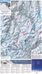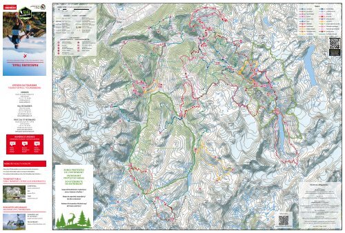
Parcours de trail running dans la région Verbier St-Bernard

You also want an ePaper? Increase the reach of your titles
YUMPU automatically turns print PDFs into web optimized ePapers that Google loves.
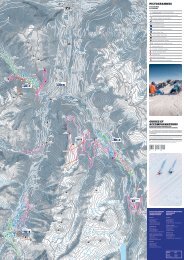
Echelle 1 : 65’000 1 cm sur <strong>la</strong> carte correspond à 650 m <strong>dans</strong> <strong>la</strong> nature<br />
TRAILS<br />
01<br />
La Crevasse<br />
101<br />
Tour <strong>de</strong>s Vil<strong>la</strong>ges<br />
0 500 1’000<br />
2’000 4’000 m<br />
02<br />
Pas <strong>de</strong> <strong>la</strong> face<br />
102<br />
Le Château via Cries<br />
6<br />
LÉGENDES - LEGENDS - LEGENDEN<br />
Forêt - Forest - Wald<br />
Route - Road - <strong>St</strong>rasse<br />
Chemin <strong>de</strong> fer -<br />
Railway - Eisenbahn<br />
Téléphérique -<br />
Cable car - Seilbahn<br />
Télésiège -<br />
Chairlift - Sesselbahn<br />
Télécabine - Gondo<strong>la</strong> - Gon<strong>de</strong>l<br />
900<br />
Zone d’habitation -<br />
Housing estate - Wohnsiedlung<br />
Frontière nationale -<br />
National bor<strong>de</strong>r - Nationalgrenze<br />
Limite zones protégées -<br />
Protected areas - Schutzgebiete<br />
Courbe <strong>de</strong> niveau -<br />
Level curve - Höhenlinien<br />
Sommet / avec croix -<br />
Summit / with cross -<br />
Gipfel / mit Kreuz<br />
01<br />
01<br />
102<br />
104<br />
102<br />
104<br />
110<br />
104<br />
03 Tour du Catogne<br />
103<br />
04 La Breya<br />
104<br />
05 Les Cols Ferret<br />
105<br />
06 Bavon<br />
106<br />
07 Mont-Brûlé<br />
107<br />
08 Saint-<strong>Bernard</strong><br />
108<br />
09 Orsières-Champex<br />
109<br />
10 Tour du Mont Ferret 110<br />
11 Trail du Vé<strong>la</strong>n<br />
Col <strong>de</strong> Mille<br />
Pierre-Avoi<br />
Col <strong>de</strong>s Avouillons<br />
Les Greniers<br />
Le grand trophée <strong>de</strong>s Combins<br />
Col du Haut Val <strong>de</strong> Bagnes<br />
Tour du barrage <strong>de</strong> Mauvoisin<br />
Tour <strong>de</strong>s cabanes<br />
Trail <strong>Verbier</strong> <strong>St</strong>-<strong>Bernard</strong><br />
LIEUX D'INTÉRÊT -<br />
POINTS OF INTEREST - SEHENSWÜRDIGKEITEN<br />
110<br />
Cabane <strong>de</strong> montagne -<br />
Mountain hut - Berghütte<br />
<strong>St</strong>ation <strong>de</strong> télécabine -<br />
Cable car station - Gon<strong>de</strong>lbahnhof<br />
03<br />
Restaurant<br />
Point <strong>de</strong> vue -<br />
View point - Aussichtspunkt<br />
Gare - <strong>St</strong>ation - Bahnhof<br />
Arrêt <strong>de</strong> bus -<br />
Bus stop - Bushaltestelle<br />
02<br />
Col - Pass - Bergpass<br />
Office du tourisme -<br />
Tourist Office - Tourismusbüro<br />
Parking - Parkp<strong>la</strong>tz<br />
110<br />
101<br />
110<br />
Cartes digitales<br />
Digital maps<br />
Digitale Karten<br />
TRAIL RUNNING ROUTES / TRAILRUNNING-ROUTEN<br />
103<br />
PARCOURS TRAIL<br />
101<br />
106<br />
106<br />
03<br />
110<br />
110<br />
108<br />
03<br />
105<br />
105<br />
OFFICES DU TOURISME<br />
TOURIST OFFICE / TOURISMBÜRO<br />
09<br />
07<br />
110<br />
107<br />
108<br />
VERBIER<br />
Route <strong>de</strong> <strong>Verbier</strong> <strong>St</strong>ation 61<br />
1936 <strong>Verbier</strong><br />
+41 27 775 38 88<br />
info@verbier.ch<br />
www.verbier.ch<br />
04<br />
07<br />
103<br />
110<br />
105<br />
107<br />
110<br />
VAL DE BAGNES<br />
P<strong>la</strong>ce <strong>de</strong> Cura<strong>la</strong><br />
1934 Le Châble VS<br />
+41 27 775 38 70<br />
lechable@verbier.ch<br />
www.val<strong>de</strong>bagnes.ch<br />
06<br />
07<br />
110<br />
PAYS DU ST-BERNARD<br />
Route <strong>de</strong> <strong>la</strong> Gare 34 – CP 92<br />
1937 Orsières<br />
+41 27 775 23 81<br />
info@saint-bernard.ch<br />
www.saint-bernard.ch<br />
www.pass-saint-bernard.ch<br />
06<br />
06<br />
109<br />
109<br />
NUMÉROS D’URGENCE<br />
EMERGENCY NUMBER / NOTRUFNUMMERN<br />
110<br />
117 144 162<br />
110<br />
Police<br />
Police<br />
Polizei<br />
Secours<br />
Emergency<br />
Notruf<br />
Météo<br />
Weather<br />
Wetter<br />
11<br />
109<br />
MOBILITÉ / MOBILITY / MOBILITÄT<br />
11<br />
Pour plus d’informations sur les horaires <strong>de</strong>s transports :<br />
For more information about transport timetables :<br />
Für weitere Informationen über die Fahrpläne <strong>de</strong>s Verkehrs :<br />
TRANSPORT PUBLIC<br />
PUBLIC TRANSPORT / ÖFFENTLICHE VERKEHRSMITTEL<br />
CARPOSTAL<br />
www.carpostal.ch<br />
CFF<br />
www.cff.ch<br />
ZONES PROTÉGÉES<br />
DE L’ENTREMONT<br />
ENTREMONT<br />
PROTECTED AREAS<br />
SCHUTZGEBIETE<br />
IM ENTREMONT<br />
Soyez particulièrement respectueux<br />
envers <strong>la</strong> faune et <strong>la</strong> flore !<br />
05<br />
10<br />
10<br />
Mentions obligatoires<br />
Éditeur<br />
<br />
Outdooractive GmbH, Grabenstrasse 15, CH - 7001 Chur<br />
switzer<strong>la</strong>nd@outdooractive.com, corp.outdooractive.com<br />
TMR<br />
www.tmrsa.ch<br />
Please be especially respectful of<br />
the flora and fauna!<br />
05<br />
Sur ordre <strong>de</strong><br />
Office <strong>de</strong> Tourisme <strong>de</strong> <strong>Verbier</strong>-Val <strong>de</strong> Bagnes et le Pays du <strong>St</strong>-<strong>Bernard</strong><br />
REMONTÉES MÉCANIQUES<br />
MOUNTAIN LIFTS / BERGBAHNEN<br />
CHAMPEX-LAC<br />
ET LA FOULY :<br />
www.saint-bernard.ch<br />
Nehmen Sie beson<strong>de</strong>rs Rücksicht auf<br />
die Fauna und Flora!<br />
08<br />
08<br />
Région online<br />
Base cartographique<br />
<br />
Geoinformationen © Outdooractive<br />
© Open<strong>St</strong>reetMap (ODbL) – Mitwirken<strong>de</strong> (www.openstreetmap.org/copyright)<br />
Modifications éditoriales <strong>de</strong> <strong>la</strong> base <strong>de</strong> <strong>la</strong> carte par le client.<br />
Réserves naturelles<br />
Bun<strong>de</strong>sinventar <strong>de</strong>r eidgenössischen Jagdbanngebiete (inkl. Routennetz)<br />
- Jagdbanngebiete<br />
Droits sur l’image<br />
Office <strong>de</strong> Tourisme <strong>de</strong> <strong>Verbier</strong>-Val <strong>de</strong> Bagnes et le Pays du <strong>St</strong>-<strong>Bernard</strong><br />
TÉLÉVERBIER :<br />
www.verbier4vallees.com<br />
Toutes les informations au meilleur <strong>de</strong> notre connaissance,<br />
mais sans garantie. Sous réserve <strong>de</strong> modifications sans préavis.<br />
outdooractive.com/r/1037876<br />
Mai 2020 – Tirage: 15’500
N°01 La Crevasse<br />
⏰ 4 h 20 min<br />
⟷ 10,5 km<br />
◢<br />
◣<br />
744 m<br />
744 m<br />
Technique<br />
moyen<br />
⭑⭑⭑⭑⭑⭑<br />
N°03 Tour du Catogne difficile<br />
⏰ 7 h 10 min<br />
⟷ 22,8 km<br />
◢<br />
◣<br />
918 m<br />
918 m<br />
Technique<br />
⭑⭑⭑⭑⭑⭑<br />
N°05 Les Cols Ferret facile<br />
⏰ 6 h 05 min<br />
⟷ 16,8 km<br />
◢<br />
◣<br />
1050 m<br />
1050 m<br />
Technique<br />
⭑⭑⭑⭑⭑⭑<br />
N°07 Mont-Brûlé moyen<br />
⏰ 6 h 30 min<br />
⟷ 15,5 km<br />
◢<br />
◣<br />
1224 m<br />
1224 m<br />
Technique<br />
⭑⭑⭑⭑⭑⭑<br />
N°09 Orsières-Champex moyen<br />
⏰ 3 h 30 min<br />
⟷ 8,3 km<br />
◢<br />
◣<br />
578 m<br />
578 m<br />
Technique<br />
⭑⭑⭑⭑⭑⭑<br />
RESTAURANTS ET<br />
HÉBERGEMENTS D’ALTITUDE<br />
MOUNTAIN RESTAURANTS AND ACCOMMODATION<br />
BERGRESTAURANTS UND UNTERKÜNFTE<br />
PAYS DU ST-BERNARD<br />
VAL FERRET<br />
CHAMPEX-LAC<br />
m<br />
2000<br />
1900<br />
1800<br />
1700<br />
1600<br />
1500<br />
1400<br />
1300<br />
1200<br />
km<br />
Levron<br />
2<br />
La Crevasse<br />
Col <strong>de</strong>s P<strong>la</strong>nches<br />
4<br />
Alpage du Tronc<br />
6<br />
8<br />
Col du Lein<br />
◢<br />
◣<br />
Levron<br />
10<br />
⏰ 3 h 05 min<br />
⟷ 6,2 km<br />
525 m<br />
525 m<br />
Tour online<br />
N°02 Pas <strong>de</strong> <strong>la</strong> face facile<br />
m<br />
1800<br />
1600<br />
1400<br />
1200<br />
1000<br />
800<br />
600<br />
400<br />
km<br />
Champex-Lac<br />
Champex, télé<br />
Champex, d'en-Bas<br />
5<br />
Sembrancher<br />
Bovernier<br />
10<br />
15<br />
Champex-Lac<br />
Champex, Le Signal<br />
Chez-les-Reuses<br />
20<br />
⏰ 3 h 55 min<br />
⟷ 7,4 km<br />
◢<br />
◣<br />
758 m<br />
758 m<br />
Tour online<br />
N°04 La Breya facile<br />
m<br />
3000<br />
2800<br />
2600<br />
2400<br />
2200<br />
2000<br />
1800<br />
1600<br />
1400<br />
km<br />
La Fouly<br />
Cabane <strong>de</strong> La Léchère<br />
2<br />
4<br />
6<br />
Grand Col Ferret<br />
8<br />
10<br />
Alpage <strong>de</strong> <strong>la</strong> Peule<br />
12<br />
Ferret<br />
14<br />
La Fouly<br />
16<br />
Tour online<br />
N°06 Bavon moyen<br />
⏰ 6 h 25 min<br />
⟷ 16,8 km<br />
◢<br />
◣<br />
1205 m<br />
1205 m<br />
m<br />
3000<br />
Cabane du Col <strong>de</strong> Mille<br />
2500<br />
Lid<strong>de</strong>s<br />
2000<br />
1500<br />
1000<br />
km<br />
2<br />
4<br />
6<br />
Mont-Brûlé<br />
8<br />
10<br />
12<br />
◢<br />
◣<br />
Lid<strong>de</strong>s<br />
14<br />
⏰ 4 h 35 min<br />
⟷ 11,7 km<br />
970 m<br />
970 m<br />
Tour online<br />
m<br />
1600<br />
1400<br />
Orsières, gare<br />
1200<br />
1000<br />
800<br />
km<br />
1<br />
2<br />
3<br />
Lac <strong>de</strong> Champex<br />
4<br />
5<br />
Chez-Les-Reuses<br />
6<br />
Orsières, gare<br />
7<br />
◢<br />
◣<br />
8<br />
⏰ 8 h 05 min<br />
⟷ 18,1 km<br />
1397 m<br />
1397 m<br />
Tour online<br />
N°08 Saint-<strong>Bernard</strong> moyen N°10 Tour du Mont Ferret difficile<br />
ALPAGE DE LA PEULE<br />
+41 27 783 10 41<br />
www.montourdumontb<strong>la</strong>nc.com<br />
BUVETTE DE L’ALPAGE<br />
DES ARS<br />
+41 79 446 20 16<br />
www.alpage<strong>de</strong>sars.ch<br />
LA LÉCHÈRE<br />
+41 27 783 30 64<br />
www.<strong>la</strong>lechere.ch<br />
COL DE FENÊTRE<br />
+41 27 783 11 88<br />
www.montourdumontb<strong>la</strong>nc.com<br />
LA BREYA<br />
+41 27 783 13 45<br />
www.champex.ch<br />
LE RELAIS D’ARPETTE<br />
+41 27 783 12 21<br />
www.arpette.ch<br />
COL DU GRAND-<br />
SAINT-BERNARD<br />
AUBERGE DE L’HOSPICE<br />
+41 27 787 11 53<br />
www.aubergehospice.ch<br />
MONT-JOUX<br />
+41 79 134 00 81<br />
Technique<br />
⭑⭑⭑⭑⭑⭑<br />
Technique<br />
⭑⭑⭑⭑⭑⭑<br />
Technique<br />
⭑⭑⭑⭑⭑⭑<br />
Technique<br />
⭑⭑⭑⭑⭑⭑<br />
Technique<br />
⭑⭑⭑⭑⭑⭑<br />
m<br />
1400<br />
1200<br />
Sembrancher<br />
1000<br />
800<br />
600<br />
km 1<br />
2<br />
Pas <strong>de</strong> <strong>la</strong> face<br />
3<br />
4<br />
5<br />
Sembrancher<br />
6<br />
Tour online<br />
m<br />
2400<br />
Champex-Lac<br />
2200<br />
2000<br />
1800<br />
1600<br />
1400<br />
1200<br />
km 1<br />
2<br />
3<br />
La Breya<br />
4<br />
5<br />
6<br />
Champex-Lac<br />
7<br />
Tour online<br />
m<br />
2800<br />
2600<br />
2400<br />
2200<br />
2000<br />
1800<br />
Lid<strong>de</strong>s<br />
1600<br />
1400<br />
1200<br />
1000<br />
km<br />
2<br />
Vichères<br />
4<br />
6<br />
8<br />
La Chaux<br />
10<br />
12<br />
14<br />
Lid<strong>de</strong>s<br />
16<br />
Tour online<br />
m<br />
Col du Grand-Saint-<strong>Bernard</strong><br />
2900<br />
2800<br />
2700<br />
2600<br />
2500<br />
2400<br />
2300<br />
2200<br />
km 2 4<br />
Col du Grand-Saint-<strong>Bernard</strong><br />
Col du Bastillon<br />
Pas <strong>de</strong>s Chevaux<br />
6 8 10<br />
Tour online<br />
m<br />
3000<br />
La Fouly<br />
2500<br />
2000<br />
1500<br />
km 2<br />
4<br />
Le Basset<br />
6<br />
8<br />
La Fouly<br />
Cabane <strong>de</strong> La Léchère<br />
Buvette <strong>de</strong><br />
l'Alpage <strong>de</strong>s Ars<br />
10<br />
12<br />
14<br />
Ferret<br />
16<br />
18<br />
Tour online<br />
DIFFICULTÉ ET TEMPS DE MARCHE<br />
DIFFICULTY AND TIME REQUIRED<br />
SCHWIERIGKEIT UND LAUFZEIT<br />
La difficulté a été estimée par les experts du Trail <strong>running</strong> <strong>de</strong> <strong>la</strong><br />
<strong>de</strong>stination, en tenant compte du dénivelé, <strong>de</strong> <strong>la</strong> distance ainsi<br />
que <strong>de</strong> <strong>la</strong> technicité du terrain, cette <strong>de</strong>rnière étant évaluée<br />
graduellement <strong>de</strong> 1 à 6.<br />
La durée <strong>de</strong>s parcours fait référence aux estimations fournies<br />
pour une randonnée. Le temps réalisé par parcours dépendant du<br />
niveau physique <strong>de</strong> chacun.<br />
The difficulty has been estimated by local <strong>trail</strong> <strong>running</strong> experts,<br />
taking into account the altitu<strong>de</strong> difference, the distance, as well as<br />
the technical aspects of the terrain which are evaluated on a scale<br />
from 1 to 6.<br />
The <strong>trail</strong> time refers to the estimations provi<strong>de</strong>d for a hike. The<br />
time achieved per <strong>trail</strong> <strong>de</strong>pends on your fitness level.<br />
Die Schwierigkeit wur<strong>de</strong> von ortsansässigen Trail<strong>running</strong>-Experten<br />
unter Berücksichtigung <strong>de</strong>s Höhenunterschieds, <strong>de</strong>r Distanz und<br />
<strong>de</strong>r Gelän<strong>de</strong>beschaffenheit eingeschätzt. Letztere wird auf einer<br />
Ska<strong>la</strong> von 1 bis 6 eingestuft.<br />
Die angegebene Laufzeit bezieht sich auf Schätzungen für<br />
eine Wan<strong>de</strong>rung. Die tatsächlich benötigte Zeit hängt von <strong>de</strong>r<br />
individuellen Kondition ab.<br />
Facile / Easy / Einfach<br />
Moyen / Medium / Mittel<br />
Difficile / Diffcult / Schwierig<br />
N°110 Tour <strong>de</strong>s cabanes Suggestion d’itinéraire sur 4 jours – Suggestions for a four-day itinerary – Routenvorschläge für vier Tage<br />
Probablement <strong>la</strong> boucle <strong>la</strong> plus complète en termes <strong>de</strong><br />
diversité <strong>de</strong>s paysages et <strong>de</strong>s terrains. Partez à <strong>la</strong> découverte <strong>de</strong>s<br />
cabanes <strong>de</strong> <strong>la</strong> vallée <strong>de</strong> Bagnes et <strong>de</strong> son riche patrimoine.<br />
Au départ du Châble, partez en direction du Mont-Brulé, vous offrant une<br />
vue à 360°. Re<strong>de</strong>scen<strong>de</strong>z ensuite jusqu’à <strong>la</strong> cabane <strong>de</strong> Mille, puis jusqu’à <strong>la</strong><br />
cabane Brunet pour vous reposer le temps d’une nuit. Le len<strong>de</strong>main rejoignez<br />
<strong>la</strong> moraine du g<strong>la</strong>cier <strong>de</strong> Corbassière, que vous traverserez à l’ai<strong>de</strong> <strong>de</strong> <strong>la</strong><br />
spectacu<strong>la</strong>ire passerelle du même nom, pour enfin apercevoir <strong>la</strong> cabane <strong>de</strong><br />
Panossière. Continuez en direction du col <strong>de</strong>s Otanes pour rejoindre le barrage<br />
<strong>de</strong> Mauvoisin puis <strong>la</strong> cabane <strong>de</strong> Chanrion, lieu idéal pour profiter d’une nuit <strong>de</strong><br />
récupération. Au réveil, longez le barrage et continuez en direction du col <strong>de</strong><br />
Sarsh<strong>la</strong>u pour atteindre <strong>la</strong> cabane <strong>de</strong> Louvie, <strong>de</strong>rnier arrêt avant <strong>de</strong> rejoindre<br />
le Châble en passant par <strong>la</strong> cabane du Mont-Fort.<br />
Probably the most complete circuit in terms of <strong>la</strong>ndscape<br />
and terrain diversity. Set off to discover the cabins of the Bagnes<br />
Valley and the area’s rich heritage.<br />
<strong>St</strong>arting from Le Châble, set off in the direction of Mont-Brûlé and admire<br />
a 360° view. Head down to the Cabane <strong>de</strong> Mille and then on to the Cabane<br />
Brunet to rest for the night. The next day, when you arrive at the moraine of<br />
the Corbassière G<strong>la</strong>cier, take the spectacu<strong>la</strong>r walkway of the same name and<br />
catch a glimpse of the FXB Panossière Mountain Refuge. Keep going in the<br />
direction of the Col <strong>de</strong>s Otanes and you’ll arrive at the Mauvoisin Dam before<br />
reaching the Cabane <strong>de</strong> Chanrion – the perfect p<strong>la</strong>ce for a good night’s rest. In<br />
the morning, continue along the dam and keep going in the direction of the<br />
Col <strong>de</strong> Sarsh<strong>la</strong>u to reach the Cabane <strong>de</strong> Louvie – the <strong>la</strong>st stop before returning<br />
to Le Châble via the Cabane du Mont-Fort.<br />
Wahrscheinlich <strong>de</strong>r Rundweg mit <strong>de</strong>r grössten Landschaftsund<br />
Gelän<strong>de</strong>vielfalt: Lernen Sie die Hütten und das reiche Kulturerbe<br />
<strong>de</strong>s Val <strong>de</strong> Bagnes kennen.<br />
Von Le Châble aus <strong>la</strong>ufen Sie zum Mont-Brulé, <strong>de</strong>r eine Rundumaussicht<br />
bietet. Dann steigen Sie ab zur Mille-Hütte und weiter zur Brunet-Hütte, wo<br />
Sie übernachten. Am nächsten Tag überqueren Sie über die spektakuläre<br />
Corbassière-Hängebrücke die Moräne <strong>de</strong>s gleichnamigen Gletschers und<br />
erblicken schliesslich die Panossière-Hütte. Weiter geht es in Richtung Col<br />
<strong>de</strong>s Otanes zum Mauvoisin-<strong>St</strong>audamm und dann zur Chanrion-Hütte, wo Sie<br />
über Nacht neue Kräfte schöpfen können. Nach <strong>de</strong>m Frühstück machen Sie<br />
sich ent<strong>la</strong>ng <strong>de</strong>s <strong>St</strong>audamms auf in Richtung Col <strong>de</strong> Sarsh<strong>la</strong>u zur Louvie-Hütte,<br />
<strong>de</strong>m letzten Halt, bevor Sie <strong>de</strong>n Rückweg nach Le Châble über die Mont-Fort-<br />
Hütte antreten.<br />
Quickfacts<br />
m<br />
3500<br />
3000<br />
2500<br />
2000<br />
1500<br />
1000<br />
500<br />
⏰ 4 jours ◢ 7000 m ⤒ 2854 m<br />
⟷ 89,0 km ◣ 7000 m ⤓ 820 m<br />
Technique<br />
km<br />
Le Châble Cabane du Col <strong>de</strong> Mille<br />
Cabane <strong>de</strong> Louvie<br />
Mont-Brûlé Cabane Brunet Cabane <strong>de</strong> Chanrion<br />
Le Châble<br />
La Côt<br />
Col <strong>de</strong>s Otanes Écuries du Crêt Médières<br />
Moay<br />
Mauvoisin Mauvoisin<br />
<strong>Verbier</strong><br />
20<br />
⭑⭑⭑⭑⭑⭑<br />
Cabane FXB à Panossière<br />
Cabane du Mont Fort<br />
Passerelle <strong>de</strong> Corbassière<br />
40<br />
60<br />
80<br />
difficile<br />
Tour online<br />
Trail <strong>Verbier</strong> <strong>St</strong>-<strong>Bernard</strong><br />
Le grand <strong>trail</strong> <strong>de</strong>s Alpes suisses, l'X-Alpine vous fera découvrir<br />
les plus beaux points <strong>de</strong> vue <strong>de</strong> <strong>la</strong> <strong>région</strong> en cumu<strong>la</strong>nt un dénivelé<br />
positif <strong>de</strong> 8'400m. Ce nouveau parcours se veut résolument<br />
alpin et constitue un réel challenge pour <strong>trail</strong>ers aguerris.<br />
Au départ <strong>de</strong> <strong>Verbier</strong>, rejoignez le sommet du Catogne où <strong>la</strong> vue saura vous<br />
récompenser ! Re<strong>de</strong>scen<strong>de</strong>z ensuite sur Champex-Lac pour vous reposer le<br />
temps d’une nuit bien méritée. Le len<strong>de</strong>main rejoignez <strong>la</strong> cabane d’Orny, puis<br />
<strong>la</strong> Fouly pour remonter en direction du mythique col du Gd-<strong>St</strong>-<strong>Bernard</strong>, pour<br />
y passer <strong>la</strong> nuit au bord du <strong>la</strong>c. Au réveil, <strong>de</strong>scen<strong>de</strong>z en direction <strong>de</strong> Bourg-<strong>St</strong>-<br />
Pierre en passant par le barrage <strong>de</strong>s Toules, pour remonter jusqu’à <strong>la</strong> cabane<br />
<strong>de</strong> Mille pour un <strong>de</strong>rnier arrêt. Au 4ème jour, re<strong>de</strong>scen<strong>de</strong>z jusqu’au vil<strong>la</strong>ge <strong>de</strong><br />
Lourtier pour attaquer « Le Mur » comme on le surnomme, avec ses 1212m <strong>de</strong><br />
dénivelé positif, pour enfin rejoindre <strong>Verbier</strong>.<br />
The great <strong>trail</strong> of the Swiss Alps, the X-Alpine will make you<br />
discover the most beautiful viewpoints of the region by cumu<strong>la</strong>ting<br />
a positive height difference of 8'400m. This new route is resolutely<br />
alpine and is a real challenge for experienced <strong>trail</strong>ers.<br />
<strong>St</strong>arting from <strong>Verbier</strong>, reach the summit of the Catogne to be rewar<strong>de</strong>d with<br />
a spectacu<strong>la</strong>r view! Head down to Champex-Lac for a well-earned night’s<br />
Suggestion d’itinéraire sur 4 jours – Suggestions for a four-day itinerary – Routenvorschläge für vier Tage<br />
rest. The next day, head for the Cabane d’Orny and then on to La Fouly, before<br />
starting the climb up the legendary Great <strong>St</strong> <strong>Bernard</strong> Pass to spend the night<br />
besi<strong>de</strong> the <strong>la</strong>ke. When you wake up, head down to Bourg-<strong>St</strong>-Pierre via the Toules<br />
dam before climbing up to the Cabane <strong>de</strong> Mille for your final stop. On the<br />
fourth day, head back down to the vil<strong>la</strong>ge of Lourtier to tackle the so-called<br />
“Wall”, with an ascent of 1,212m, before finally returning to <strong>Verbier</strong>.<br />
Der grosse Trail <strong>de</strong>r Schweizer Alpen, <strong>de</strong>r X-Alpine, lässt Sie<br />
die schönsten Aussichtspunkte <strong>de</strong>r Region ent<strong>de</strong>cken, in<strong>de</strong>m er<br />
eine positive Höhendifferenz von 8'400m kumuliert. Diese neue<br />
Route ist resolut alpin und eine echte Herausfor<strong>de</strong>rung für erfahrene<br />
Trailer.<br />
Besteigen Sie von <strong>Verbier</strong> aus <strong>de</strong>n Catogne und geniessen Sie die Aussicht!<br />
Anschliessend legen Sie im weiter unten gelegenen Champex-Lac über Nacht<br />
eine wohlverdiente Ruhepause ein. Am nächsten Tag <strong>la</strong>ufen Sie zur Ornyhütte,<br />
weiter nach La Fouly und dann hinauf zur Passhöhe <strong>de</strong>s legendären Grossen<br />
Sankt Bernhard, wo Sie am See übernachten. Am nächsten Morgen geht es am<br />
<strong>St</strong>audamm von Les Toules vorbei nach Bourg-Saint-Pierre und dann hinauf zur<br />
Mille-Hütte zu einer letzten Rast. Am vierten Tag steigen Sie erst nach Lourtier<br />
ab und nehmen dann die sogenannte «Wand» mit ihren 1212 Höhenmetern in<br />
Angriff, bevor Sie wie<strong>de</strong>r in <strong>Verbier</strong> eintreffen.<br />
Quickfacts<br />
m<br />
3500<br />
3000<br />
2500<br />
2000<br />
1500<br />
1000<br />
500<br />
⏰ 4 jours ◢ 8375 m ⤒ 2830 m<br />
⟷ 111,0 km ◣ 8375 m ⤓ 711 m<br />
km<br />
Technique<br />
<strong>Verbier</strong> Cabane d'Orny CAS/SAC Cabane du Col <strong>de</strong> Mille<br />
Champex-Lac Col du Grand-Saint-<strong>Bernard</strong><br />
<strong>Verbier</strong><br />
Catogne<br />
Bourg-<strong>St</strong>-Pierre La Chaux<br />
Sembrancher<br />
La Fouly<br />
Lourtier<br />
20<br />
⭑⭑⭑⭑⭑⭑<br />
40<br />
60<br />
80<br />
100<br />
difficile<br />
Tour online<br />
CABANES / MOUNTAIN HUTS / HÜTTEN<br />
PAYS DU ST-BERNARD<br />
CABANE DE MILLE<br />
+41 27 783 11 82<br />
www.cabane<strong>de</strong>mille.ch<br />
CABANE D’ORNY<br />
+41 27 783 18 87<br />
www.cabanedorny.ch<br />
VAL DE BAGNES<br />
CABANE BRUNET<br />
+41 27 778 18 10<br />
www.cabanebrunet.ch<br />
CABANE DE LOUVIE<br />
+41 27 778 17 40<br />
www.louvie.ch<br />
CABANE DE CHANRION<br />
+47 27 778 12 09<br />
www.chanrion.ch<br />
CABANE DU VALSOREY<br />
+41 27 787 11 22<br />
www.valsorey.ch<br />
CABANE DU VÉLAN<br />
+41 27 787 13 13<br />
www.ve<strong>la</strong>n.ch<br />
CABANE DU MONT-FORT<br />
+41 27 778 13 84<br />
www.cabanemontfort.ch<br />
CABANE FXB PANOSSIÈRE<br />
+41 27 771 33 32<br />
www.panossiere.ch<br />
VAL DE BAGNES<br />
HAUTS DE VERBIER<br />
CROIX-DE-CŒUR<br />
+41 27 775 25 36<br />
www.verbier4vallées.com<br />
CHEZ DANY<br />
+41 27 771 25 24<br />
www.chezdany.ch<br />
LA MARLÉNAZ<br />
+41 27 771 54 41<br />
www.marlenaz.com<br />
LA MARMOTTE<br />
+41 27 771 68 34<br />
www.<strong>la</strong>marmotte-verbier.com<br />
LE NAMASTÉ<br />
+41 27 771 57 73<br />
www.namaste-verbier.ch<br />
LE DAHU<br />
+41 27 778 20 00<br />
www.ledahu.ch<br />
HAUT VAL DE BAGNES<br />
CAFÉ DU MAZOT<br />
+41 27 778 11 47<br />
www.lemazot-fionnay.com<br />
CAFÉ-RESTAURANT<br />
DE LA PROMENADE<br />
+41 27 778 12 40<br />
www.bonatchiesse.ch<br />
CAMPING<br />
FORÊT DES MÉLÈZES<br />
ET VILLAGE SIOUX<br />
+41 27 778 12 40<br />
www.bonatchiesse.ch<br />
HÔTEL DE MAUVOISIN<br />
+41 27 778 11 30<br />
www.hotel<strong>de</strong>mauvoisin.ch<br />
VOLLÈGES<br />
BUVETTE DU COL DU LEIN<br />
+41 77 535 11 43<br />
www.buvette-alpage-ch/lein<br />
BUVETTE ALPAGE<br />
COL DES PLANCHES<br />
+41 27 785 23 29<br />
www.alpage-col-<strong>de</strong>s-p<strong>la</strong>nches.ch<br />
BUVETTE ALPAGE DU TRONC<br />
+41 79 381 57 18<br />
www.alpage-du-tronc.ch<br />
CONSEILS PRATIQUES<br />
PRACTICAL ADVICE / PRAKTISCHE RATSCHLÄGE<br />
• Chaque parcours est balisé avec l’ai<strong>de</strong> d’une signalisation<br />
“Destination Trail <strong>Verbier</strong> <strong>St</strong>-<strong>Bernard</strong>” comprenant un co<strong>de</strong><br />
couleur re<strong>la</strong>tif à <strong>la</strong> difficulté.<br />
• Cette carte fournit <strong>de</strong>s recommandations d’itinéraires et ne<br />
remp<strong>la</strong>ce pas un matériel cartographique plus précis.<br />
• En montagne, les risques sont inhérents au milieu naturel.<br />
• Le réseau <strong>de</strong> téléphonie mobile peut être inaccessible sur les<br />
parcours proposés.<br />
Les informations publiées sur cette carte n’engagent aucunement<br />
<strong>la</strong> responsabilité <strong>de</strong>s auteurs.<br />
• Each <strong>trail</strong> is marked with “Destination Trail <strong>Verbier</strong> <strong>St</strong>-<strong>Bernard</strong>”<br />
signs which are colour-co<strong>de</strong>d to reflect the difficulty.<br />
• This map provi<strong>de</strong>s suggested itineraries and is not inten<strong>de</strong>d to<br />
rep<strong>la</strong>ce more <strong>de</strong>tailed maps.<br />
• Mountains have inherent natural risks.<br />
• Mobile phone networks may be inaccessible on the proposed <strong>trail</strong>s.<br />
The authors responsible for the information provi<strong>de</strong>d in this<br />
brochure have no legal liability whatsoever.<br />
N°11 Trail du Vé<strong>la</strong>n difficile<br />
m Bourg-<strong>St</strong>-Pierre<br />
3000<br />
2500<br />
2000<br />
1500<br />
km<br />
Pointe <strong>de</strong> Penne<br />
2<br />
4<br />
6<br />
Cab. <strong>de</strong> Valsorey CAS<br />
8<br />
10<br />
12<br />
14<br />
⏰ 9 h 40 min<br />
⟷ 20,0 km<br />
◢<br />
◣<br />
1780 m<br />
1780 m<br />
Technique<br />
Bourg-<strong>St</strong>-Pierre<br />
Cabane du Vé<strong>la</strong>n CAS<br />
16<br />
18<br />
20<br />
⭑⭑⭑⭑⭑⭑<br />
Tour online<br />
N°101 Tour <strong>de</strong>s Vil<strong>la</strong>ges difficile<br />
⏰ 6 h 35 min<br />
⟷ 21,0 km<br />
◢<br />
◣<br />
1100 m<br />
1100 m<br />
N°102 Le Château via Cries moyen<br />
m<br />
2200<br />
2000<br />
1800<br />
1600<br />
1400<br />
1200<br />
1000<br />
800<br />
600<br />
km<br />
Le Châble<br />
Cotterg, vil<strong>la</strong>ge<br />
2<br />
4<br />
Cries<br />
6<br />
⏰ 5 h 15 min<br />
⟷ 13,0 km<br />
◢<br />
◣<br />
1100 m<br />
1100 m<br />
Technique<br />
Le Châble<br />
Chapelle <strong>de</strong> <strong>St</strong>-Christophe<br />
8<br />
10<br />
Cotterg, vil<strong>la</strong>ge<br />
12<br />
⏰ 6 h 25 min<br />
⟷ 19,0 km<br />
◢<br />
◣<br />
1300 m<br />
1300 m<br />
⭑⭑⭑⭑⭑⭑<br />
Tour online<br />
N°104 Pierre-Avoi difficile<br />
m<br />
2800<br />
<strong>Verbier</strong><br />
2600<br />
2400<br />
2200<br />
2000<br />
1800<br />
1600<br />
1400<br />
1200<br />
km 2<br />
Savoleyres<br />
Pierre-Avoi<br />
4<br />
6<br />
8<br />
10<br />
12<br />
14<br />
16<br />
18<br />
⏰ 7 h 25 min<br />
⟷ 21,0 km<br />
◢<br />
◣<br />
1300 m<br />
1300 m<br />
Technique<br />
Col <strong>de</strong> <strong>la</strong> Croix-<strong>de</strong>-Coeur<br />
<strong>Verbier</strong><br />
Les P<strong>la</strong>nards<br />
Col <strong>de</strong>s Mines<br />
La Marlénaz<br />
◢<br />
◣<br />
20<br />
⏰ 10 h 10 min<br />
⟷ 24,0 km<br />
2000 m<br />
2000 m<br />
⭑⭑⭑⭑⭑⭑<br />
Tour online<br />
N°106 Les Greniers difficile<br />
m<br />
3000<br />
Lourtier<br />
2500<br />
Les Greniers<br />
2000<br />
1500<br />
1000<br />
500<br />
km<br />
2<br />
4<br />
6<br />
Col Termin<br />
8<br />
Cabane <strong>de</strong> Louvie<br />
10<br />
12<br />
Fionnay<br />
14<br />
⏰ 8 h 45 min<br />
⟷ 19,0 km<br />
N°103 Col <strong>de</strong> Mille difficile N°105 Col <strong>de</strong>s Avouillons difficile N°107 Le grand trophée <strong>de</strong>s Combins difficile<br />
◢<br />
◣<br />
1730 m<br />
1730 m<br />
Technique<br />
16<br />
◢<br />
◣<br />
Lourtier<br />
18<br />
⏰ 8 h 30 min<br />
⟷ 19,0 km<br />
1600 m<br />
1600 m<br />
⭑⭑⭑⭑⭑⭑<br />
Tour online<br />
N°108 Col du Haut Val <strong>de</strong> Bagnes moyen<br />
m<br />
Fionnay<br />
Col <strong>de</strong> Sarsh<strong>la</strong>u<br />
Écurie du Crêt<br />
2500<br />
2000<br />
1500<br />
km<br />
2<br />
4<br />
6<br />
Col du Bec d'Aigle<br />
8<br />
Cabane <strong>de</strong> Louvie<br />
10<br />
⏰ 8 h 35 min<br />
⟷ 14,0 km<br />
◢<br />
◣<br />
1500 m<br />
1500 m<br />
Technique<br />
12<br />
◢<br />
◣<br />
Fionnay<br />
⏰ 8 h 30 min<br />
⟷ 24,0 km<br />
1600 m<br />
1600 m<br />
⭑⭑⭑⭑⭑⭑<br />
Tour online<br />
N°109 Tour du barrage <strong>de</strong> Mauvoisin difficile<br />
Dès 1 nuit, bénéficiez d’une infinité<br />
d’activités gratuites ou à tarif réduit<br />
grâce au VIP Pass.<br />
From 1 night, take advantage of an<br />
infinite number of activities, free or<br />
at a reduced-price, with the VIP Pass.<br />
Genießen Sie ab 1 Nacht eine<br />
unendliche Anzahl von kostenlosen<br />
o<strong>de</strong>r ermäßigten Aktivitäten<br />
mit <strong>de</strong>m VIP-Pass.<br />
verbier.ch/vip-pass<br />
• Alle <strong>St</strong>recken sind mit <strong>de</strong>m Schild «Destination Trail <strong>Verbier</strong><br />
<strong>St</strong>-<strong>Bernard</strong>» gekennzeichnet, auf <strong>de</strong>m ein Farbco<strong>de</strong> die Schwierigkeit<br />
anzeigt.<br />
• Diese Karte enthält Routenempfehlungen. Sie bietet keinen Ersatz<br />
für exakteres Kartenmaterial.<br />
• In <strong>de</strong>r natürlichen Gebirgsumgebung muss mit Gefahren<br />
gerechnet wer<strong>de</strong>n.<br />
• Es kann sein, dass auf Teilen <strong>de</strong>r vorgesch<strong>la</strong>genen <strong>St</strong>recken kein<br />
Mobilfunknetz verfügbar ist.<br />
Die Autoren dieser Karte übernehmen keine Haftung für ihre<br />
Informationen.<br />
m<br />
Le Châble<br />
1400<br />
1200<br />
1000<br />
800<br />
km<br />
Fontenelle<br />
2<br />
Chapelle <strong>de</strong>s Verneys<br />
4<br />
6<br />
Sarreyer Lourtier<br />
8<br />
10<br />
12<br />
Champsec<br />
14<br />
16<br />
18<br />
Technique<br />
Le Châble<br />
Bruson<br />
20<br />
⭑⭑⭑⭑⭑⭑<br />
Tour online<br />
m<br />
3000<br />
La Côt<br />
2800<br />
Mont-Brûlé<br />
2600<br />
Col du Chargerat<br />
2400<br />
2200<br />
2000<br />
Moay<br />
1800<br />
1600<br />
1400<br />
1200<br />
km 2 4 6 8<br />
Cabane du Col <strong>de</strong> Mille<br />
10<br />
12<br />
Ecuries <strong>de</strong> Mille<br />
14<br />
Technique<br />
16<br />
La Côt<br />
Moay<br />
18<br />
⭑⭑⭑⭑⭑⭑<br />
Tour online<br />
m Passerelle <strong>de</strong> Corbassière<br />
Col <strong>de</strong>s Avouillons<br />
3000<br />
Lourtier<br />
2500<br />
Cabane Brunet<br />
2000<br />
1500<br />
1000<br />
500<br />
km<br />
5<br />
10<br />
Cabane FXB à Panossière<br />
15<br />
Mont-Repos<br />
20<br />
Technique<br />
Fionnay<br />
Lourtier<br />
⭑⭑⭑⭑⭑⭑<br />
Tour online<br />
m<br />
Fionnay<br />
Col <strong>de</strong>s Otanes<br />
3000<br />
Cabane FXB à Panossière<br />
2500<br />
Mont-Repos<br />
2000<br />
1500<br />
1000<br />
km<br />
2<br />
4<br />
6<br />
8<br />
10<br />
12<br />
Mauvoisin<br />
Bonatchiesse<br />
14<br />
16<br />
Technique<br />
Fionnay<br />
18<br />
⭑⭑⭑⭑⭑⭑<br />
Tour online<br />
m<br />
3000<br />
Mauvoisin<br />
2800<br />
La Tsessette<br />
2600<br />
2400<br />
2200<br />
2000<br />
1800<br />
1600<br />
km<br />
5<br />
10<br />
15<br />
20<br />
Technique<br />
Col <strong>de</strong> Tsofeiret<br />
Cabane <strong>de</strong> Chanrion<br />
Écuries du Gietro<br />
Pont du Lancet<br />
Mauvoisin<br />
⭑⭑⭑⭑⭑⭑<br />
Tour online<br />
GRATUIT / FREE / FREI<br />
Accès piétons sur toutes les remontées mécaniques<br />
jusqu’au Mont-Fort (3’330m)<br />
Pe<strong>de</strong>strian access on all lifts up to Mont-Fort (3’330m)<br />
Zugang für Fussgänger auf allen Aufzügen bis zum<br />
Mont-Fort (3’330m)<br />
&<br />
Bus postaux / Postal buses / Postauto