staatsolie nieuws
staatsolie nieuws
staatsolie nieuws

Create successful ePaper yourself
Turn your PDF publications into a flip-book with our unique Google optimized e-Paper software.
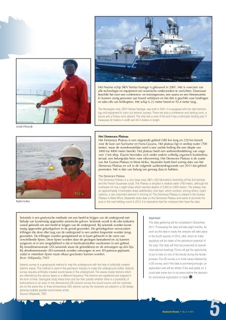
Lesda Pelswijk<br />
Rakhi Kalka<br />
Seismiek is een geofysische methode om een beeld te krijgen van de ondergrond met<br />
behulp van kunstmatig opgewekte seismische golven. Seismiek wordt in de olie-industrie<br />
vooral gebruikt om een beeld te krijgen van de ondergrond. Bij seismiek worden kunstmatig<br />
opgewekte geluidsgolven in de grond gezonden. De geluidsgolven veroorzaken<br />
trillingen die door elke laag van de ondergrond in een andere frequentie worden teruggezonden.<br />
De trillingen worden geregistreerd en in kaart gebracht in de vorm van<br />
verschillende lijnen. Deze lijnen worden door de geologen bestudeerd en zij kunnen<br />
aangeven of er een mogelijkheid is dat er koolwaterstoffen voorkomen in een gebied.<br />
Bij tweedimensionale (2D-)seismiek staan de geluidsbron en de ontvangers op één lijn.<br />
Bij driedimensionale (3D-)seismiek worden ontvangers in een 3D-patroon geplaatst,<br />
zodat er meerdere lijnen naast elkaar geschoten kunnen worden.<br />
Bron: Wikipedia, TNO<br />
Seismic survey is a geophysical method to map the underground with the help of artificially created<br />
seismic waves. This method is used in the petroleum industry to make the underground visible. Seismic<br />
survey requires artificially created sound waves in the underground. The waves create tremors which<br />
are reflected by the various layers in a different frequency. The tremors are registered and mapped in<br />
the form of lines. Geologists study these lines and can then predict whether there is a possibility of<br />
hydrocarbons in an area. In two dimensional (2D) seismic survey the sound source and the receivers<br />
are on the same line. In three-dimensional (3D) seismic survey the receivers are placed in a 3D design<br />
allowing multiple parallel sound waves shots.<br />
Source: Wikipedia, TNO<br />
Het Noorse schip SR/V Veritas Vantage is gebouwd in 2001. Het is voorzien van<br />
alle technologie en equipment om seismische onderzoeken te verrichten. Daarnaast<br />
beschikt het over een conference- en trainingsroom, een sauna en een fitnessruimte.<br />
Er kunnen zestig personen aan boord verblijven en het dek is geschikt voor landingen<br />
en take-offs van helikopters. Het schip is 22 meter breed en 93.4 meter lang.<br />
The Norwegian ship, SR/V Veritas Vantage, was built in 2001. It is equipped with the right technology<br />
and equipment to carry out seismic surveys. There are also a conference and training room, a<br />
sauna and a fitness room aboard. The ship has a crew of 60 and it has a helicopter landing pad. It<br />
measures 22 meters in width and 93.4 meters in length.<br />
Het Demerara Plateau<br />
Het Demerara Plateau is een uitgestrekt gebied (380 km lang en 220 km breed)<br />
voor de kust van Suriname en Frans-Guyana. Het plateau ligt in ondiep water (700<br />
meter), maar de noordwestelijke rand is een zachte helling die een diepte van<br />
3000 tot 4000 meter bereikt. Het plateau heeft een sedimentbedekking van ongeveer<br />
3 km diep. Daarin bevinden zich onder andere volledig organisch koolstofmateriaal,<br />
een belangrijke bron voor olievorming. Het Demerara Plateau is de zuster<br />
van het Guinea Plateau in West-Afrika. Staatsolie heeft heel weinig data van het<br />
Demerara Plateau en wil in de volgende aanbestedingsronde van 2013 dat gebied<br />
promoten. Het is dan van belang om genoeg data te hebben.<br />
The Demerara Plateau<br />
The Demerara Plateau is a very large area (380 x 220 kilometers) stretching off the Surinamese<br />
and the French Guyanese coast. The Plateau is situated in shallow water (700 meter), although the<br />
northwest rim has a slight slope which reaches depths of 3,000 to 4,000 meters. The plateau has<br />
an approximately 3 kilometers deep sedimentary rock layer, which contains, among others, hydrocarbons,<br />
a very important element in forming oil. The Demerara Plateau is related to the Guinea<br />
Plateau in West Africa. Staatsolie lacks data on the Demerara Plateau and wants to promote the<br />
area in the next bidding round in 2013. It is imperative that the company then have the data.<br />
Appraisal<br />
The data gathering will be completed in December<br />
2011. Processing the data will take eight months. As<br />
soon as the data is ready the analysis will take place<br />
in the fourth quarter of 2012, after which an initial<br />
appraisal will be made of the petroleum potential of<br />
the area. The data will then be presented at several<br />
international meetings. Firms will get the opportunity<br />
to put in bids on one of the blocks during the tender<br />
process. The 2D survey is in most cases followed by<br />
a 3D survey, and if the data is promising enough, an<br />
exploration well will be drilled. If the well yields oil, it<br />
could take some four to six years before the decision<br />
for commercial exploitation is made.<br />
Staatsolie Nieuws • No. 4 • 2011<br />
5