Statens Luftfartsvæsen ATS-instruks 14 Kommunikation
Statens Luftfartsvæsen ATS-instruks 14 Kommunikation
Statens Luftfartsvæsen ATS-instruks 14 Kommunikation

Create successful ePaper yourself
Turn your PDF publications into a flip-book with our unique Google optimized e-Paper software.
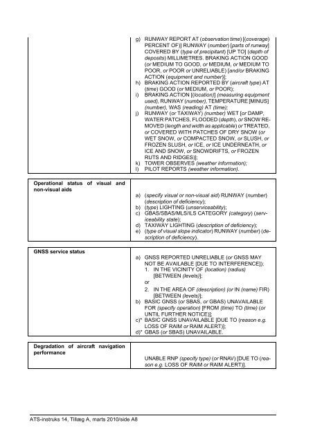
Operational status of visual and<br />
non-visual aids<br />
GNSS service status<br />
Degradation of aircraft navigation<br />
performance<br />
<strong>ATS</strong>-<strong>instruks</strong> <strong>14</strong>, Tillæg A, marts 2010/side A8<br />
g) RUNWAY REPORT AT (observation time) [(coverage)<br />
PERCENT OF)] RUNWAY (number) [parts of runway]<br />
COVERED BY (type of precipitant) [UP TO] (depth of<br />
deposits) MILLIMETRES. BRAKING ACTION GOOD<br />
(or MEDIUM TO GOOD, or MEDIUM, or MEDIUM TO<br />
POOR, or POOR or UNRELIABLE) [and/or BRAKING<br />
ACTION (equipment and number)];<br />
h) BRAKING ACTION REPORTED BY (aircraft type) AT<br />
(time) GOOD (or MEDIUM, or POOR);<br />
i) BRAKING ACTION [(location)] (measuring equipment<br />
used), RUNWAY (number), TEMPERATURE [MINUS]<br />
(number), WAS (reading) AT (time);<br />
j) RUNWAY (or TAXIWAY) (number) WET [or DAMP,<br />
WATER PATCHES, FLOODED (depth), or SNOW RE-<br />
MOVED (length and width as applicable) or TREATED,<br />
or COVERED WITH PATCHES OF DRY SNOW (or<br />
WET SNOW, or COMPACTED SNOW, or SLUSH, or<br />
FROZEN SLUSH, or ICE, or ICE UNDERNEATH, or<br />
ICE AND SNOW, or SNOWDRIFTS, or FROZEN<br />
RUTS AND RIDGES)];<br />
k) TOWER OBSERVES (weather information);<br />
l) PILOT REPORTS (weather information).<br />
a) (specify visual or non-visual aid) RUNWAY (number)<br />
(description of deficiency);<br />
b) (type) LIGHTING (unserviceability);<br />
c) GBAS/SBAS/MLS/ILS CATEGORY (category) (serviceability<br />
state);<br />
d) TAXIWAY LIGHTING (description of deficiency);<br />
e) (type of visual slope indicator) RUNWAY (number) (description<br />
of deficiency).<br />
a) GNSS REPORTED UNRELIABLE (or GNSS MAY<br />
NOT BE AVAILABLE [DUE TO INTERFERENCE]);<br />
1. IN THE VICINITY OF (location) (radius)<br />
[BETWEEN (levels)];<br />
or<br />
2. IN THE AREA OF (description) (or IN (name) FIR)<br />
[BETWEEN (levels)];<br />
b) BASIC GNSS (or SBAS, or GBAS) UNAVAILABLE<br />
FOR (specify operation) [FROM (time) TO (time) (or<br />
UNTIL FURTHER NOTICE)];<br />
c)* BASIC GNSS UNAVAILABLE [DUE TO (reason e.g.<br />
LOSS OF RAIM or RAIM ALERT)];<br />
d)* GBAS (or SBAS) UNAVAILABLE.<br />
UNABLE RNP (specify type) (or RNAV) [DUE TO (reason<br />
e.g. LOSS OF RAIM or RAIM ALERT)].