English & Deutsch - Kungsbacka kommun
English & Deutsch - Kungsbacka kommun
English & Deutsch - Kungsbacka kommun

Erfolgreiche ePaper selbst erstellen
Machen Sie aus Ihren PDF Publikationen ein blätterbares Flipbook mit unserer einzigartigen Google optimierten e-Paper Software.
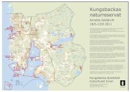
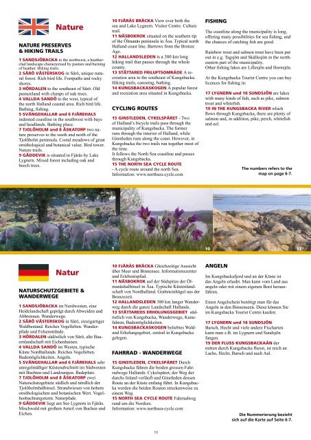
Nature<br />
NATURE PRESERVES<br />
& HIKING TRAILS<br />
1 SANDSJÖBACKA to the northwest, a heatherclad<br />
landscape characterised by pasture and burning<br />
of heather. Hiking trails.<br />
2 SÄRÖ VÄSTERSKOG in Särö, unique natural<br />
forest. Rich bird life. Footpaths and rocky<br />
shores.<br />
3 HÖRDALEN to the southeast of Särö. Old<br />
pastureland with clumps of oak trees.<br />
4 VALLDA SANDÖ to the west, typical of<br />
the north Halland coastal area. Rich bird life.<br />
Bathing, fishing.<br />
5 SVÄNGEHALLAR and 6 FJÄREHALS<br />
indented coastline in the southwest with bays<br />
and headlands. Bathing place.<br />
7 TJOLÖHOLM and 8 ÄSKATORP two nature<br />
preserves to the south and north of the<br />
Tjolöholm peninsula. Costal meadows of great<br />
ornithological and botanical value. Bird tower.<br />
Nature trails.<br />
9 GÄDDEVIK is situated in Fjärås by Lake<br />
Lygnern. Mixed forest including oak and<br />
beech trees.<br />
Natur<br />
NATURSCHUTZGEBIETE &<br />
WANDERWEGE<br />
1 SANDSJÖBACKA im Nordwesten, eine<br />
Heidelandschaft geprägt durch Abweiden und<br />
Abbrennen. Wanderwege.<br />
2 SÄRÖ VÄSTERSKOG in Särö, einzigartiger<br />
Waldbestand. Reiches Vogelleben. Wanderpfade<br />
und Felsenstrände.<br />
3 HÖRDALEN südöstlich von Särö, alte Bauernlandschaft<br />
mit Eichenhainen.<br />
4 VALLDA SANDÖ im Westen, typische<br />
Küste Nordhallands. Reiches Vogelleben.<br />
Bademöglichkeiten. Angeln.<br />
5 SVÄNGEHALLAR and 6 FJÄREHALS sehr<br />
unregelmäßiger Küstenabschnitt im Südwesten<br />
mit Buchten und Landzungen. Badeplatz.<br />
7 TJOLÖHOLM and 8 ÄSKATORP zwei<br />
Naturschutzgebiete südlich und nördlich der<br />
Tjolöholmhalbinsel. Strandwiesen von hohem<br />
ornithologischen und botanischen Wert. Vogelbeobachtungsturm.<br />
Naturpfade.<br />
9 GÄDDEVIK liegt am See Lygnern in Fjärås.<br />
Mischwald mit großem Anteil von Buchen und<br />
Eichen.<br />
10 FJÄRÅS BRÄCKA View over both the<br />
sea and Lake Lygnern. Visitor Centre. Culture<br />
trail.<br />
11 NÄSBOKROK situated on the southern tip<br />
of the Ölmanäs peninsula in Åsa. Typical north<br />
Halland coast line. Barrows from the Bronze<br />
Age.<br />
12 HALLANDSLEDEN is a 380 km long<br />
hiking trail that passes through the whole<br />
county.<br />
13 STÄTTARED FRILUFTSOMRÅDE A recreation<br />
area to the southeast of <strong>Kungsbacka</strong>.<br />
Hiking trails, canoeing, bathing.<br />
14 KUNGSBACKASKOGEN A popular forest<br />
and recreation area situated in <strong>Kungsbacka</strong>.<br />
CYCLING ROUTES<br />
15 GINSTLEDEN, CYKELSPÅRET - Two<br />
of Halland’s bicycle trails pass through the<br />
municipality of <strong>Kungsbacka</strong>. The former<br />
runs through the interior of Halland, while<br />
Ginstleden runs along the coast. However, in<br />
<strong>Kungsbacka</strong> the two trails run together most of<br />
the time.<br />
It follows the North Sea coastline and passes<br />
through <strong>Kungsbacka</strong>.<br />
15 THE NORTH SEA CYCLE ROUTE<br />
- A cycle route around the north Sea.<br />
Information: www.northsea-cycle.com<br />
10 FJÄRÅS BRÄCKA Gleichzeitige Aussicht<br />
über Meer und Binnensee. Informationszenter<br />
und Erlebenispfad.<br />
11 NÄSBOKROK auf der Südspitze der Ölmanäshalbinsel<br />
in Åsa. Typische Küstenlandschaft<br />
von Nordhalland. Grabsteinhügel aus der<br />
Bronzezeit.<br />
12 HALLANDSLEDEN 380 km langer Wanderweg<br />
durch die ganze Landschaft Hallands.<br />
13 STÄTTAREDS ERHOLUNGSGEBIET südöstlich<br />
von <strong>Kungsbacka</strong>, Wanderwege, Kanufahren,<br />
Bademöglichkeiten.<br />
14 KUNGSBACKASKOGEN beliebtes Wald-<br />
und Erholungsgebiet, zentral in <strong>Kungsbacka</strong><br />
gelegen.<br />
FAHRRAD - WANDERWEGE<br />
15 GINSTLEDEN, CYKELSPÅRET Durch<br />
<strong>Kungsbacka</strong> führen die beiden grossen Fahrradwege<br />
Hallands: Cykelspåret, der Weg der<br />
durchs Inland verläuft und Ginstleden dessen<br />
Route an der Küste entlang führt. In <strong>Kungsbacka</strong><br />
werden die beiden Routen streckenweise zu<br />
einem Weg.<br />
15 NORTH SEA CYCLE ROUTE Fahrradweg<br />
rund um die Nordsee.<br />
Information: www.northsea-cycle.com<br />
10<br />
10<br />
FISHING<br />
The coastline along the municipality is long,<br />
offering many possibilities for sea fishing, and<br />
the chances of catching fish are good.<br />
Rainbow trout and salmon trout have been put<br />
out in e.g. Tagsjön and Skållesjön in the northeastern<br />
part of the municipality.<br />
Other fishing lakes are Lillesjön and Hornsjön.<br />
At the <strong>Kungsbacka</strong> Tourist Centre you can buy<br />
licences for fishing in:<br />
17 LYGNERN und 18 SUNDSJÖN are lakes<br />
with many kinds of fish, such as pike, salmon<br />
trout and whitefish.<br />
19 IN THE KUNGSBACKA RIVER which<br />
flows through <strong>Kungsbacka</strong>, there are plenty of<br />
salmon and, in addition, pike, perch, whitefish<br />
and eel.<br />
ANGELN<br />
The numbers refers to the<br />
map on page 6-7.<br />
1 10 11<br />
Im <strong>Kungsbacka</strong>fjord und an der Küste ist<br />
das Angeln erlaubt. Man kann vom Land aus<br />
angeln oder mit einem eigenen Boot herausfahren.<br />
Einen Angelschein benötigt man für das<br />
Angeln in den Binnenseen. Diese können Sie<br />
im <strong>Kungsbacka</strong> Tourist Centre kaufen:<br />
17 LYGNERN und 18 SUNDSJÖN<br />
Barsch, Hecht und viele andere Fischarten<br />
kann man z.B. im Lygnern und Sundsjön<br />
fangen.<br />
19 DER FLUSS KUNGSBACKAÅN der<br />
mitten durch <strong>Kungsbacka</strong> fliesst, ist reich an<br />
Lachs, Hecht, Barsch und auch Aal.<br />
Die Nummerierung bezieht<br />
sich auf die Karte auf Seite 6-7.