LTBB Master Land Use Plan - Little Traverse Bay Bands of Odawa ...
LTBB Master Land Use Plan - Little Traverse Bay Bands of Odawa ...
LTBB Master Land Use Plan - Little Traverse Bay Bands of Odawa ...

You also want an ePaper? Increase the reach of your titles
YUMPU automatically turns print PDFs into web optimized ePapers that Google loves.
THE MODEL<br />
This need for a predictive mechanism for land acquisition decisions was discussed at some length<br />
by the staff team when developing this document. It was decided early on that a causal attractantrepellant<br />
type <strong>of</strong> model would most easily be integrated into the unique variety <strong>of</strong> land uses and<br />
landforms in this part <strong>of</strong> Michigan 3, although the prevailing methodologies would need to be greatly<br />
streamlined and simplified.<br />
Therefore, a base list <strong>of</strong> factors and characteristics was drawn up, assigned to either increase the<br />
potential for development at a particular site, or increase the limitations on development (from the<br />
Tribe’s presumed point <strong>of</strong> view, <strong>of</strong> course). A rating system was then applied, whereby the factors<br />
that rank high in development potential or limitations were given up to 10 points, and a reduction in<br />
either influence then reduces the score all the way down to 1 point for very slight potential or<br />
limitation.<br />
While clearly the model is not sophisticated enough for more thoroughly developed urban areas,<br />
in rural areas such as northwest lower Michigan there are a relatively smaller set <strong>of</strong> variables that<br />
promote the likelihood <strong>of</strong> development. Conversely, the overall sense or desire for acknowledgment<br />
<strong>of</strong> the environmental limitations on development is relatively constant across populations in this area.<br />
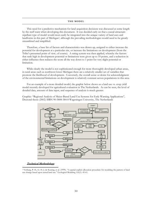
For an example <strong>of</strong> a more detailed model, the graphic below shows us a land use vs. crop yield<br />
model recently developed for agricultural evaluation in The Netherlands. As can be seen, the level <strong>of</strong><br />
detailed data, amount <strong>of</strong> data input, and sequence <strong>of</strong> analysis is much greater.<br />
Graphic: “Regional Analysis <strong>of</strong> Maize-Based <strong>Land</strong> <strong>Use</strong> Systems for Early Warning Applications”,<br />
Doctoral thesis (2002) ISBN 90-5808-584-8 Wageningen University, The Netherlands<br />
Technical Methodology<br />
3 Verburg, P. H., G. H. J. de Koning, et al. (1999). “A spatial explicit allocation procedure for modeling the pattern <strong>of</strong> land<br />
use change based upon actual land use.” Ecological Modeling 116(1): 45-61.<br />
30