Marblehead in 1700 - The Marblehead Museum and Historical Society
Marblehead in 1700 - The Marblehead Museum and Historical Society
Marblehead in 1700 - The Marblehead Museum and Historical Society

Create successful ePaper yourself
Turn your PDF publications into a flip-book with our unique Google optimized e-Paper software.
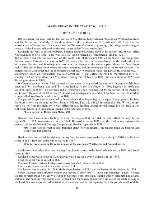
MARBLEHEAD IN THE YEAR <strong>1700</strong>. NO. 2.<br />
BY SIDNEY PERLEY.<br />
THE accompany<strong>in</strong>g map <strong>in</strong>cludes that section of <strong>Marblehead</strong> ly<strong>in</strong>g between Pleasant <strong>and</strong> Wash<strong>in</strong>gton streets<br />
<strong>and</strong> the harbor <strong>and</strong> westerly of Waldron street to the western end of Rowl<strong>and</strong>'s hill. This was the<br />
western part of the section of the town known as "Newtown" a hundred years ago, the bridge on Wash<strong>in</strong>gton<br />
street, at School street, <strong>in</strong>dicated on the map, be<strong>in</strong>g called "Newtown bridge."<br />
Rowl<strong>and</strong>'s hill was so called, probably, because Richard Rowl<strong>and</strong> lived at its eastern end. It was called<br />
Newtown hill at one time. This was laid out <strong>and</strong> granted as “ recompense” l<strong>and</strong> <strong>in</strong> 1726.<br />
<strong>The</strong> orig<strong>in</strong>al road <strong>in</strong>to the town ran on the south side of Rowl<strong>and</strong>'s hill, a little higher than the present<br />
Prospect street This was the way <strong>in</strong> 1677, but soon after the course was changed to the north side of the<br />
hill where Pleasant <strong>and</strong> Wash<strong>in</strong>gton streets now run, except at the western part, above the "workhouse<br />
rocks." <strong>The</strong> dotted l<strong>in</strong>es show where the street now runs, <strong>and</strong> the cont<strong>in</strong>uous l<strong>in</strong>es the former location. <strong>The</strong><br />
eastern end of V<strong>in</strong>e street <strong>and</strong> the short narrow court near "workhouse rocks" are parts of the orig<strong>in</strong>al way.<br />
Wash<strong>in</strong>gton street was the ancient way to <strong>Marblehead</strong>. It was called the road to <strong>Marblehead</strong> <strong>in</strong> 1727;<br />
country road or ma<strong>in</strong> street <strong>in</strong> 1736; street lead<strong>in</strong>g out of town <strong>in</strong> 1815; the ma<strong>in</strong> street <strong>in</strong> 1827; <strong>and</strong><br />
Wash<strong>in</strong>gton street <strong>in</strong> 1848.<br />
Waldron street was a way from the earliest settlement. It was called the way to or through the fish fence<br />
l<strong>and</strong>s <strong>in</strong> 1734; Waldron's lane <strong>in</strong> 1754; street lead<strong>in</strong>g to the fish fences <strong>in</strong> 1797; highway <strong>in</strong> 1807; <strong>and</strong><br />
Waldron street <strong>in</strong> 1880. <strong>The</strong> northern end of Waldron's court was laid out by the owners of the Andrews<br />
lot, to reach the rear of the lot before 1734; <strong>and</strong> was subsequently extended, from tune to time, as needed.<br />
It was called Waldron's court as early as 1842.<br />
<strong>The</strong> part of Gregory street <strong>in</strong>cluded <strong>in</strong> this section had its beg<strong>in</strong>n<strong>in</strong>g <strong>in</strong> the right of way granted by John<br />
Waldron (shown on the map) to Rev. Samuel Willard, Feb. 21, 1682,* <strong>in</strong> order that Mr. Willard might<br />
reach his lot from the highway. It was called the road lead<strong>in</strong>g through the fish fences <strong>in</strong> 1808; road or way<br />
to the fish, fences <strong>in</strong> 1811; <strong>and</strong> road lead<strong>in</strong>g to the fish yards <strong>in</strong> 1852.<br />
*Essex Registry of Deeds, book 34, leaf 258.<br />
Barnard street was a way lead<strong>in</strong>g between the rope-walks† <strong>in</strong> 1764. It was called the way to the<br />
ropewalk <strong>in</strong> 1827; ropemaker's court <strong>in</strong> 1845; Barnard street <strong>in</strong> 1852; <strong>and</strong> the road or way between the<br />
ropewalk of the <strong>Marblehead</strong> Cordage Company <strong>and</strong> Hawkes' ropewalk <strong>in</strong> 1853.<br />
†On either side of what is now Barnard street were ropewalks, the longest be<strong>in</strong>g six hundred <strong>and</strong><br />
seventy-five feet <strong>in</strong> length.<br />
Hawkes street was called the highway lead<strong>in</strong>g from Redstone cove to the hay scales‡ <strong>in</strong> 1810, <strong>and</strong> Hawkes<br />
street <strong>in</strong> 1867. Hawkes' court was so called <strong>in</strong> 1867.<br />
‡<strong>The</strong> hay scales were on the eastern corner of the junction of Wash<strong>in</strong>gton <strong>and</strong> Prospect streets.<br />
South street was called the street lead<strong>in</strong>g from Reed's corner to the South schoolhouse <strong>in</strong> 1802; <strong>and</strong> South<br />
street <strong>in</strong> 1880.<br />
Rowl<strong>and</strong> street was laid out <strong>in</strong> 1726, <strong>and</strong> was called the road over Rowl<strong>and</strong>'s hill <strong>in</strong> 1845.<br />
Prospect street was so called <strong>in</strong> 1847.<br />
Chestnut, Commercial <strong>and</strong> Cottage streets were so called respectively <strong>in</strong> 1852.<br />
L<strong>in</strong>dsey street was called a new street about 1854.<br />
<strong>The</strong> harbor was so called <strong>in</strong> 1715; <strong>Marblehead</strong> harbor <strong>in</strong> 1735; <strong>and</strong> the harbor of <strong>Marblehead</strong> <strong>in</strong> 1739.<br />
Robert JBarttett <strong>and</strong> Nathaniel Walton <strong>and</strong> Martha Munjoy lots. <strong>The</strong>se lots belonged to Rev. William<br />
Walton of <strong>Marblehead</strong> very early. He died <strong>in</strong> October, 1668, <strong>in</strong>testate, leav<strong>in</strong>g widow Elizabeth <strong>and</strong> several<br />
children. <strong>The</strong> next year the county court ordered that the widow should have the use of the estate as long as<br />
she lived. She was appo<strong>in</strong>ted adm<strong>in</strong>istratrix of the estate, <strong>and</strong> <strong>in</strong> that capacity, for forty pounds worth of debts<br />
10