Marblehead in 1700 - The Marblehead Museum and Historical Society
Marblehead in 1700 - The Marblehead Museum and Historical Society
Marblehead in 1700 - The Marblehead Museum and Historical Society

Create successful ePaper yourself
Turn your PDF publications into a flip-book with our unique Google optimized e-Paper software.
MARBLEHEAD IN.THE YEAR <strong>1700</strong> NO. 4<br />
BY SIDNEY PERLEY<br />
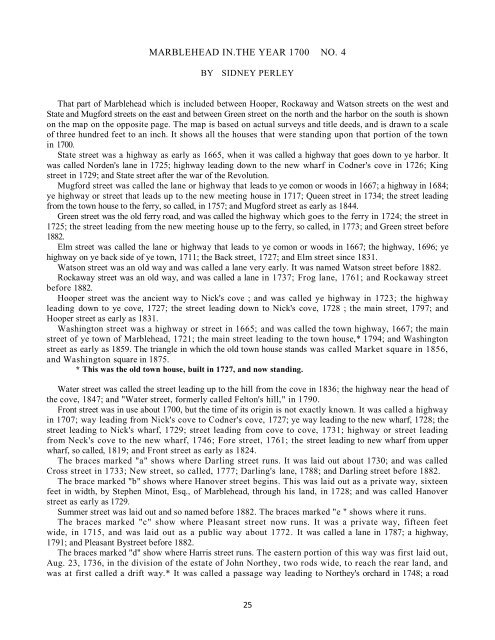
That part of <strong>Marblehead</strong> which is <strong>in</strong>cluded between Hooper, Rockaway <strong>and</strong> Watson streets on the west <strong>and</strong><br />
State <strong>and</strong> Mugford streets on the east <strong>and</strong> between Green street on the north <strong>and</strong> the harbor on the south is shown<br />
on the map on the opposite page. <strong>The</strong> map is based on actual surveys <strong>and</strong> title deeds, <strong>and</strong> is drawn to a scale<br />
of three hundred feet to an <strong>in</strong>ch. It shows all the houses that were st<strong>and</strong><strong>in</strong>g upon that portion of the town<br />
<strong>in</strong> <strong>1700</strong>.<br />
State street was a highway as early as 1665, when it was called a highway that goes down to ye harbor. It<br />
was called Norden's lane <strong>in</strong> 1725; highway lead<strong>in</strong>g down to the new wharf <strong>in</strong> Codner's cove <strong>in</strong> 1726; K<strong>in</strong>g<br />
street <strong>in</strong> 1729; <strong>and</strong> State street after the war of the Revolution.<br />
Mugford street was called the lane or highway that leads to ye comon or woods <strong>in</strong> 1667; a highway <strong>in</strong> 1684;<br />
ye highway or street that leads up to the new meet<strong>in</strong>g house <strong>in</strong> 1717; Queen street <strong>in</strong> 1734; the street lead<strong>in</strong>g<br />
from the town house to the ferry, so called, <strong>in</strong> 1757; <strong>and</strong> Mugford street as early as 1844.<br />
Green street was the old ferry road, <strong>and</strong> was called the highway which goes to the ferry <strong>in</strong> 1724; the street <strong>in</strong><br />
1725; the street lead<strong>in</strong>g from the new meet<strong>in</strong>g house up to the ferry, so called, <strong>in</strong> 1773; <strong>and</strong> Green street before<br />
1882.<br />
Elm street was called the lane or highway that leads to ye comon or woods <strong>in</strong> 1667; the highway, 1696; ye<br />
highway on ye back side of ye town, 1711; the Back street, 1727; <strong>and</strong> Elm street s<strong>in</strong>ce 1831.<br />
Watson street was an old way <strong>and</strong> was called a lane very early. It was named Watson street before 1882.<br />
Rockaway street was an old way, <strong>and</strong> was called a lane <strong>in</strong> 1737; Frog lane, 1761; <strong>and</strong> Rockaway street<br />
before 1882.<br />
Hooper street was the ancient way to Nick's cove ; <strong>and</strong> was called ye highway <strong>in</strong> 1723; the highway<br />
lead<strong>in</strong>g down to ye cove, 1727; the street lead<strong>in</strong>g down to Nick's cove, 1728 ; the ma<strong>in</strong> street, 1797; <strong>and</strong><br />
Hooper street as early as 1831.<br />
Wash<strong>in</strong>gton street was a highway or street <strong>in</strong> 1665; <strong>and</strong> was called the town highway, 1667; the ma<strong>in</strong><br />
street of ye town of <strong>Marblehead</strong>, 1721; the ma<strong>in</strong> street lead<strong>in</strong>g to the town house,* 1794; <strong>and</strong> Wash<strong>in</strong>gton<br />
street as early as 1859. <strong>The</strong> triangle <strong>in</strong> which the old town house st<strong>and</strong>s was called Market square <strong>in</strong> 1856,<br />
<strong>and</strong> Wash<strong>in</strong>gton square <strong>in</strong> 1875.<br />
* This was the old town house, built <strong>in</strong> 1727, <strong>and</strong> now st<strong>and</strong><strong>in</strong>g.<br />
Water street was called the street lead<strong>in</strong>g up to the hill from the cove <strong>in</strong> 1836; the highway near the head of<br />
the cove, 1847; <strong>and</strong> "Water street, formerly called Felton's hill," <strong>in</strong> 1790.<br />
Front street was <strong>in</strong> use about <strong>1700</strong>, but the time of its orig<strong>in</strong> is not exactly known. It was called a highway<br />
<strong>in</strong> 1707; way lead<strong>in</strong>g from Nick's cove to Codner's cove, 1727; ye way lead<strong>in</strong>g to the new wharf, 1728; the<br />
street lead<strong>in</strong>g to Nick's wharf, 1729; street lead<strong>in</strong>g from cove to cove, 1731; highway or street lead<strong>in</strong>g<br />
from Neck's cove to the new wharf, 1746; Fore street, 1761; the street lead<strong>in</strong>g to new wharf from upper<br />
wharf, so called, 1819; <strong>and</strong> Front street as early as 1824.<br />
<strong>The</strong> braces marked "a" shows where Darl<strong>in</strong>g street runs. It was laid out about 1730; <strong>and</strong> was called<br />
Cross street <strong>in</strong> 1733; New street, so called, 1777; Darl<strong>in</strong>g's lane, 1788; <strong>and</strong> Darl<strong>in</strong>g street before 1882.<br />
<strong>The</strong> brace marked "b" shows where Hanover street beg<strong>in</strong>s. This was laid out as a private way, sixteen<br />
feet <strong>in</strong> width, by Stephen M<strong>in</strong>ot, Esq., of <strong>Marblehead</strong>, through his l<strong>and</strong>, <strong>in</strong> 1728; <strong>and</strong> was called Hanover<br />
street as early as 1729.<br />
Summer street was laid out <strong>and</strong> so named before 1882. <strong>The</strong> braces marked "e " shows where it runs.<br />
<strong>The</strong> braces marked "c" show where Pleasant street now runs. It was a private way, fifteen feet<br />
wide, <strong>in</strong> 1715, <strong>and</strong> was laid out as a public way about 1772. It was called a lane <strong>in</strong> 1787; a highway,<br />
1791; <strong>and</strong> Pleasant Bystreet before 1882.<br />
<strong>The</strong> braces marked "d" show where Harris street runs. <strong>The</strong> eastern portion of this way was first laid out,<br />
Aug. 23, 1736, <strong>in</strong> the division of the estate of John Northey, two rods wide, to reach the rear l<strong>and</strong>, <strong>and</strong><br />
was at first called a drift way.* It was called a passage way lead<strong>in</strong>g to Northey's orchard <strong>in</strong> 1748; a road<br />
25