Marblehead in 1700 - The Marblehead Museum and Historical Society
Marblehead in 1700 - The Marblehead Museum and Historical Society
Marblehead in 1700 - The Marblehead Museum and Historical Society

Create successful ePaper yourself
Turn your PDF publications into a flip-book with our unique Google optimized e-Paper software.
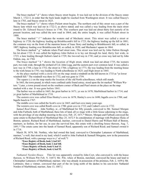
<strong>The</strong> brace marked " d " shows where Stacey street beg<strong>in</strong>s. It was laid out <strong>in</strong> the division of the Stacey estate<br />
March 1, 1722-3, <strong>in</strong> order that the back l<strong>and</strong>s might be reached from Wash<strong>in</strong>gton street. It was called Stacey's<br />
lane <strong>in</strong> 1783, <strong>and</strong> Stacey street <strong>in</strong> 1825.<br />
<strong>The</strong> brace marked " e " shows where Pickett street beg<strong>in</strong>s. <strong>The</strong> northern end of this street was a part of the<br />
Stacey lane which was laid out <strong>in</strong> 1722-3, as above stated; <strong>and</strong> was called a way lead<strong>in</strong>g from the ma<strong>in</strong> street<br />
round to Dr. Edward Stacey's house <strong>in</strong> 1746. <strong>The</strong> southern part was laid out about thirty feet easterly of its<br />
present location, <strong>and</strong> was called the new road <strong>in</strong> 1864; <strong>and</strong>, the entire length, it was called Pickett street <strong>in</strong><br />
1880.<br />
<strong>The</strong> brace marked " f " <strong>in</strong>dicates the western end of Mechanic street. This street was called a street or<br />
highway <strong>in</strong> 1720; the highway lead<strong>in</strong>g up Brimblecomb's hill <strong>in</strong> 1723; the highway lead<strong>in</strong>g up the hill <strong>in</strong> 1801;<br />
the common way on the front of the mansion house of Isaac Story <strong>and</strong> lead<strong>in</strong>g to Brimbleeom's hill, so called, <strong>in</strong><br />
1807; highway lead<strong>in</strong>g over Brimblecome hill, so called, <strong>in</strong> 1820; <strong>and</strong> Mechanics' square <strong>in</strong> 1864.<br />
<strong>The</strong> braces marked " g " <strong>in</strong>dicate where Pearl street runs. This street was laid out by John Oulton through<br />
his lot about 1723. It was called the highway John Oulton is to lay out through his l<strong>and</strong>, thirty feet wide, <strong>in</strong><br />
1723; a lane lead<strong>in</strong>g through Oulton's l<strong>and</strong> <strong>in</strong> 1729; the two-rod way <strong>in</strong> 1741; <strong>and</strong> ye cross way laid out by John<br />
Oulton, esq., <strong>in</strong> 1744.<br />
<strong>The</strong> brace marked " h " shows the location of High street, which was laid out about 1735, the western<br />
part, two rods wide, through the orchard of Col. John Legg, <strong>and</strong> the eastern part over common l<strong>and</strong>. It was called a<br />
new way <strong>in</strong> 1744; a lane <strong>in</strong> 1752; the street <strong>in</strong> 1766; a highway <strong>in</strong> 1771; the way lead<strong>in</strong>g from the meet<strong>in</strong>g house<br />
to the work house <strong>in</strong> 1791; way lead<strong>in</strong>g to North schoolhouse <strong>in</strong> 1825; <strong>and</strong> High street <strong>in</strong> 1845.<br />
At the place marked with a circle (O) on the map stood a w<strong>in</strong>dmill on the hill known <strong>in</strong> 1733 as "ye lower<br />
w<strong>in</strong>dmill hill." <strong>The</strong> w<strong>in</strong>dmill was there <strong>in</strong> 1732, <strong>and</strong> was gone <strong>in</strong> 1759.<br />
<strong>The</strong> square (□) on the map marks the location of the old North schoolhouse, which still st<strong>and</strong>s.<br />
In 1663, the town pound, <strong>in</strong> which were conf<strong>in</strong>ed cattle found astray, stood upon the lot marked "William Waters."<br />
Later, a town pound stood on the southern corner of Back <strong>and</strong> Pearl streets at the place on the map<br />
marked with a star. It was gone before 1841.<br />
<strong>The</strong> harbor was so called <strong>in</strong> 1665; the great harbor <strong>in</strong> 1671; ye sea <strong>in</strong> 1678; <strong>Marblehead</strong> harbor <strong>in</strong> 1714; <strong>and</strong><br />
ye great harbor of <strong>Marblehead</strong> <strong>in</strong> 1718.<br />
<strong>The</strong> eastern cove was called Elias Henley's cove <strong>in</strong> 1678; Henley's cove <strong>in</strong> 1690; Ingalls cove <strong>in</strong> 1708; <strong>and</strong><br />
Ingalls beach <strong>in</strong> 1767.<br />
<strong>The</strong> middle cove was called the Scott's cove <strong>in</strong> 1665; <strong>and</strong> East cove many years ago.<br />
<strong>The</strong> western cove was called Reed's cove <strong>in</strong> <strong>1700</strong>; great cove <strong>in</strong> 1722; <strong>and</strong> Codner's cove <strong>in</strong> 1732.<br />
Samuel Reed House. John Northey, sr., of <strong>Marblehead</strong> for fifty pounds, conveyed to Mr. Samuel Morgan<br />
<strong>and</strong> John Furbush, both of <strong>Marblehead</strong>, these lots of l<strong>and</strong>, all ye stage with a little house adjo<strong>in</strong><strong>in</strong>g to the stage,<br />
with the privilege of one shallop moor<strong>in</strong>g <strong>in</strong> the cove, Feb. 25, 1671.* Messrs. Morgan <strong>and</strong> Furbush conveyed the<br />
same estate to Richard Reed of <strong>Marblehead</strong> May 25, 1672.† In consideration of marriage with Prudence Hicks of<br />
Boston, sp<strong>in</strong>ster, Richard Reed of <strong>Marblehead</strong>, mar<strong>in</strong>er, conveyed to Daniel Harris <strong>and</strong> William Hall of Boston,<br />
mar<strong>in</strong>ers, as feofees, for her use, <strong>in</strong> case she survived him, this estate with a dwell<strong>in</strong>g house thereon, Aug. 7,<br />
1691.* <strong>The</strong> estate came <strong>in</strong>to the h<strong>and</strong>s of Samuel Reed, apparently son of Richard Reed; <strong>and</strong> Samuel owned it<br />
<strong>in</strong> 1714.<br />
March 30, 1674, Mr. Northey, who had owned this l<strong>and</strong>, conveyed to Christopher Lattamore of <strong>Marblehead</strong>,<br />
mar<strong>in</strong>er," a well, that stood <strong>in</strong> my l<strong>and</strong>, which I sould to John Furbush & Samuell Morga<strong>in</strong>e, now <strong>in</strong> the possession<br />
of Richard Reed, with a passage waye to y e sd well."†<br />
*Essex Registry of Deeds, book 3, leaf 167.<br />
†Essex Registry of Deeds, book 3, leaf 168.<br />
* Essex Registry of Deeds, book 9, leaf 13.<br />
†Essex Registry of Deeds, book 4, leaf 55.<br />
Nathaniel Norden House. This lot was apparently owned by John Coyt, who conveyed it, with the house<br />
thereon, to William Pitt Feb. 9, 1647‡ Mr. Pitt, when of Boston, merchant, conveyed the house <strong>and</strong> l<strong>and</strong> to<br />
Christopher Lattamore of <strong>Marblehead</strong>, mar<strong>in</strong>er, who was already <strong>in</strong> possession of the premises, Feb. 2, 1659.§ Mr.<br />
Lattimore, then a v<strong>in</strong>tner, conveyed that part of the lot ly<strong>in</strong>g north of the dashes to his son-<strong>in</strong>-law Nathaniel<br />
Norden of <strong>Marblehead</strong>, mar<strong>in</strong>er, June 13, 1687.||<br />
32