Marblehead in 1700 - The Marblehead Museum and Historical Society
Marblehead in 1700 - The Marblehead Museum and Historical Society
Marblehead in 1700 - The Marblehead Museum and Historical Society

Create successful ePaper yourself
Turn your PDF publications into a flip-book with our unique Google optimized e-Paper software.
of Governor W<strong>in</strong>throp <strong>and</strong> had brought over from Engl<strong>and</strong> "at great charges, all th<strong>in</strong>gs fitt<strong>in</strong>g for tak<strong>in</strong>g wild<br />
fowl by way of Duck Coy." He obta<strong>in</strong>ed leave of the General Court to set his decoys <strong>in</strong> these ponds. It was<br />
ordered that no man "should shoote <strong>in</strong> any gunn with<strong>in</strong> a half mile of the ponds, nor use any other means<br />
for the disturbance of the fowle there." Mr. Down<strong>in</strong>g returned to Engl<strong>and</strong> <strong>and</strong> probably died about 1657,<br />
hav<strong>in</strong>g granted this fifty acres of l<strong>and</strong> to his gr<strong>and</strong>son Solomon Stoddard of Boston, gentleman, "fellow of ye<br />
College of Cambridge." For fifty pounds, Mr. Stoddard conveyed the l<strong>and</strong> to Moses Maverick <strong>and</strong> Richard<br />
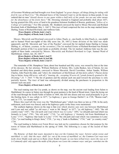
Rowl<strong>and</strong>, both of <strong>Marblehead</strong>, May 1, 1667.‡ This tract of l<strong>and</strong> comprised the lots on the map marked James<br />
Darl<strong>in</strong>g, Estate of Richard Rowl<strong>and</strong>, <strong>and</strong> Ambrose Gale.<br />
†Essex Registry of Deeds, book 1, leaf 1.<br />
‡Essex Registry of Deeds, book 3, leaf 26<br />
Messrs. Maverick <strong>and</strong> Rowl<strong>and</strong> conveyed to Johns Peach, sr., one-fourth, to John Peach, jr., one-eighth<br />
<strong>and</strong> to Samuel Ward one-eighth of this fifty acres Jan. 20, 1667.§ Some division of the l<strong>and</strong> was made<br />
apparently <strong>and</strong> Mr. Maverick <strong>and</strong> "one of the Peaches" conveyed the lot marked James Darl<strong>in</strong>g to George<br />
Darl<strong>in</strong>g, sr., of Salem, yeoman, <strong>in</strong> the seventies.|| <strong>The</strong> lot marked Estate of Richard Rowl<strong>and</strong> was Richard<br />
Rowl<strong>and</strong>'s portion of the Coy pond l<strong>and</strong>s as probably divided. <strong>The</strong> lot marked Ambrose Gale was the oneeighth<br />
of these l<strong>and</strong>s- conveyed by Messrs. Maverick <strong>and</strong> Richard Rowl<strong>and</strong> to Capt. Samuel Ward of<br />
<strong>Marblehead</strong>, v<strong>in</strong>tner, Jan. 20, 1667.*<br />
§Essex Registry of Deeds, book 3, leaf 27.<br />
||Essex Registry of Deeds, book 14, leaf 308.<br />
*Essex Registry of Deeds, book 3, leaf 27.<br />
<strong>The</strong> rema<strong>in</strong>der of Mr. Humphreys' farm, about four hundred <strong>and</strong> fifty acres, was owned by him at the time<br />
of his decease. By her attorney, William Hathorne of Salem, Mrs. Lydia Bankes, late of Salem, for one<br />
hundred <strong>and</strong> thirty-three pounds, conveyed to Moses Maverick, David Corwithen, Arthur S<strong>and</strong><strong>in</strong>, William<br />
Charles, John Peach the elder, <strong>and</strong> "others the <strong>in</strong>habitants of <strong>Marblehead</strong>, all that farm called y e Playnes farme<br />
l<strong>in</strong>g <strong>in</strong> Salem, be<strong>in</strong>g 400 acres, with all y e hous<strong>in</strong>g, &c., except<strong>in</strong>g 50 acres & 2 ponds formerly granted to Mr.<br />
Down<strong>in</strong>g," 24: 7: 1645.Ӡ <strong>The</strong> list of grantees <strong>and</strong> the amount each one paid toward the purchase is only<br />
partially known. <strong>The</strong> tract of l<strong>and</strong> was subsequently divided among the purchasers <strong>in</strong> proportion to the<br />
amount each one paid.<br />
†Essex Registry of Deed, book 1, leaf 29.<br />
<strong>The</strong> road runn<strong>in</strong>g near the Coy ponds, as shown on the map, was the ancient road lead<strong>in</strong>g from Salem to<br />
<strong>Marblehead</strong>. Its course <strong>in</strong> Salem was through the great pastures to the head of Broad street. Upon the lay<strong>in</strong>g out<br />
of the road through the South Fields of Salem <strong>in</strong> 1666, this fell <strong>in</strong>to disuse <strong>and</strong> was used pr<strong>in</strong>cipally to go to<br />
the Darl<strong>in</strong>g farm. It was called, <strong>in</strong> 1677, "ye highway y t goes to George Darl<strong>in</strong>'s"; <strong>in</strong> 1728, "Boston road";<br />
<strong>and</strong>, <strong>in</strong> 1731, "ye country road”.<br />
Where this road left the town was the "<strong>Marblehead</strong> gate," which was there as late as 1708. In the early<br />
settlement, each town was fenced, <strong>and</strong> at the highways gates <strong>in</strong> the fence were ma<strong>in</strong>ta<strong>in</strong>ed.<br />
<strong>The</strong> southern highway shown on the map is that over which electric cars now run between <strong>Marblehead</strong><br />
<strong>and</strong> Lynn <strong>and</strong> was called "ye old waye y t went to Mr. Bang's" <strong>in</strong> 1677; "ye old highway," 1682; "the old<br />
country road," 1687; "the old path <strong>and</strong> road which was to Lynn," 1691; "ye old path <strong>and</strong> road which was<br />
formerly to Lynn," 1701; "the old path," 1710; "ye old highway y t formerly led from <strong>Marblehead</strong> to<br />
Lynn," 1715 ; "highway that leads to Lynn," 1719; "the old path <strong>and</strong> road which was sometimes to Lynn,'<br />
1724 ; "ye road lead<strong>in</strong>g to K<strong>in</strong>g's farm," 1728 ; “ye way y t leads to Reddans," 1734; " <strong>and</strong> “ye country road,"<br />
1739.<br />
<strong>The</strong> road lead<strong>in</strong>g to Salem over Forest River was laid out by committees chosen for that purpose by the<br />
towns of Salem <strong>and</strong> <strong>Marblehead</strong> <strong>in</strong> the spr<strong>in</strong>g of 1666. <strong>The</strong> follow<strong>in</strong>g is a copy of the record of their<br />
return:—<br />
<strong>The</strong> Returne: of thofe that weare Apoynted to laye owt the Common hie waye: betwixt salem towne <strong>and</strong><br />
marblhed: is vydz: that the waye: shall: lye: out of the towne of marblhed: as: the Common Cart waye now<br />
lyeth: fower Rodds wyde <strong>and</strong> soe to Runn: fower Rodds broade: as wee have m'ked trees: neere the way as It<br />
is Commonly ufed: only uppon the midle of the playne wee Leave the common waye: <strong>and</strong> goe: somwhat one the<br />
3