

dem users manual - asprs
dem users manual - asprs
dem users manual - asprs

Create successful ePaper yourself
Turn your PDF publications into a flip-book with our unique Google optimized e-Paper software.
Chapter 6: IFSAR<br />
Chapter 6 explains the capabilities and limitations of Interferometric Synthetic Aperture Radar (IFSAR), both<br />
airborne and spaceborne. This technology sees through clouds, is less weather dependent that other technologies,<br />
and acquires elevation data sets of large areas at relatively low costs. It is important that DEM <strong>users</strong> understand that<br />
elevations derived from x-band IFSAR are initially the elevations of top surfaces (treetops and rooftops) and not the<br />
bare-earth terrain, so if you need DSMs of large areas, this technology may be best for you. DTMs can be produced<br />
from IFSAR DSMs, and a sample IFSAR data set, including an orthorectified radar image, is included on the DVD<br />
that accompanies this 2 nd edition. Figure 5 helps explain how Synthetic Aperture Radar (SAR) works.<br />
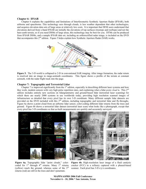
Figure 5. The 3-D world is collapsed to 2-D in conventional SAR imaging. After image formation, the radar return<br />
is resolved into an image in range-azimuth coordinates. This figure shows a profile of the terrain at constant<br />
azimuth, with the radar flight track into the page.<br />
Chapter 7: Topographic and Terrestrial Lidar<br />
Chapter 7 is improved significantly from the 1 st edition, especially in describing different laser systems and how<br />
they work, modern sensors with very high pulse repetition rates, and explaining what a lidar point cloud is. This 2 nd<br />
edition includes entirely new sections on lidargrammetry and ground-based lidar (terrestrial laser scanning) for<br />
which there are nearly 2000 systems in use worldwide today, providing high resolution scanned images of<br />
infrastructure so detailed that every pixel has its own 3-D coordinate. Many different sample lidar datasets are<br />
provided on the DVD included with this 2 nd edition, including topographic and terrestrial lidar and fly-throughs.<br />
Figure 6a shows a point cloud from an airborne lidar sensor, color-coding different lidar returns from the trees and<br />
ground. Figure 6b shows a terrestrial lidar dataset (terrestrial laser scan) what looks like a photograph, except that<br />
every pixel has 3-D coordinates so that as-built measurements are quickly and accurately surveyed.<br />
Figure 6a. Topographic lidar “point clouds,” colorcoded<br />
for 1 st through 4 th returns. Many 1 st returns<br />
(yellow) reach the ground, whereas some of the 3 rd<br />
returns (red) are still in the trees and don’t penetrate.<br />
Figure 6b. High-resolution laser image of a fluid catalytic<br />
cracker (FCC) in a refinery captured with a phased-based<br />
scanner. Each pixel has 3-D x/y/z coordinates.<br />
MAPPS/ASPRS 2006 Fall Conference<br />
November 6 – 10, 2006 * San Antonio, Texas


