FINAL PNF -- Jackson Square - Boston Redevelopment Authority
FINAL PNF -- Jackson Square - Boston Redevelopment Authority
FINAL PNF -- Jackson Square - Boston Redevelopment Authority

Create successful ePaper yourself
Turn your PDF publications into a flip-book with our unique Google optimized e-Paper software.
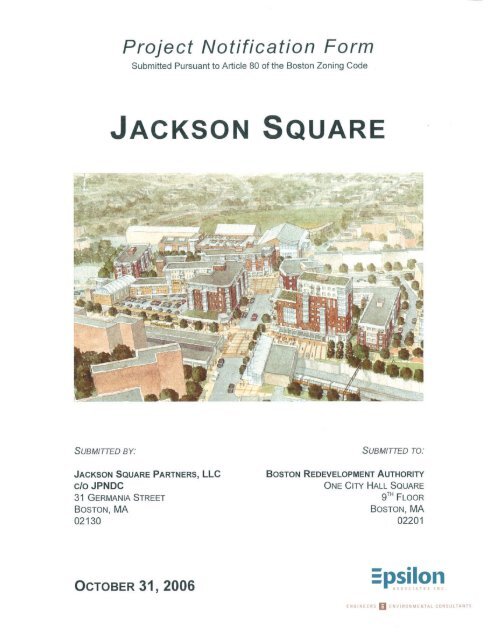
Project Notification Form<br />
Submitted Pursuant to Article 80 of the <strong>Boston</strong> Zoning Code<br />
JACKSON SQUARE<br />
Submitted to:<br />
BOSTON REDEVELOPMENT AUTHORITY<br />
One City Hall <strong>Square</strong><br />
<strong>Boston</strong>, MA 02201<br />
Submitted by:<br />
JACKSON SQUARE PARTNERS, LLC<br />
C/O JPNDC<br />
31 Germania Street<br />
<strong>Boston</strong>, MA 02130<br />
Affiliated Developers:<br />
Mitchell Properties, LLC Gravestar, Inc.<br />
Prepared by:<br />
EPSILON ASSOCIATES, INC.<br />
3 Tower Clock Place<br />
Suite 250<br />
Maynard, MA 01754<br />
October 31, 2006<br />
In Association with:<br />
GLC Development Resources, LLC<br />
Stull and Lee, Inc.<br />
Tise Design Associates<br />
Goulston & Storrs<br />
Judith Nitsch Engineering, Inc.<br />
Howard/Stein-Hudson Associates<br />
McPhail Associates<br />
Blue Wave Strategies
TABLE OF CONTENTS<br />
PAGE<br />
1.0 SUMMARY 1-1<br />
1.1 Project Identification 1-1<br />
1.2 Overview 1-2<br />
1.2.1 Introduction 1-2<br />
1.2.2 Project Site 1-11<br />
1.2.3 Proposed Development 1-14<br />
1.2.4 Phase 1 Project Scope 1-14<br />
1.2.5 Public Review / Process 1-17<br />
1.2.6 Public Benefits 1-17<br />
1.3 Consistency with Zoning 1-23<br />
1.3.1 Zoning Districts 1-23<br />
1.3.2 Permitted Uses 1-24<br />
1.3.3 Dimensional Requirements 1-24<br />
1.3.4 Floor Area Ratio 1-24<br />
1.3.5 Design Requirements 1-24<br />
1.3.6 Off-Street Parking and Loading 1-25<br />
1.3.7 Zoning Approval Mechanism 1-25<br />
1.3.8 <strong>Boston</strong> Civic Design Commission Review 1-25<br />
1.3.9 Inclusionary Housing 1-25<br />
1.3.10 Linkage 1-26<br />
1.4 State Impact Reviews 1-26<br />
1.5 Legal Information 1-26<br />
1.5.1 Legal Judgments 1-26<br />
1.5.2 History of Tax Arrears on Property 1-26<br />
1.5.3 Evidence of Site Control/Nature of Public Easements 1-26<br />
1.6 Public Agencies 1-27<br />
2.0 PROJECT DESCRIPTION 2-1<br />
2.1 Existing Site 2-1<br />
2.2 Proposed Development Program 2-1<br />
2.2.1 Building Program 2-1<br />
2.2.2 Approximate Dimensions 2-12<br />
2.3 Planning Context 2-12<br />
2.4 Schedule 2-19<br />
3.0 ASSESSMENT OF DEVELOPMENT REVIEW COMPONENTS 3-1<br />
3.1 Transportation 3-1<br />
3.1.1 Introduction 3-1<br />
3.1.2 Project Description 3-1<br />
3.1.3 Site Access 3-2<br />
1772/<strong>PNF</strong>/ <strong>Jackson</strong> <strong>Square</strong> Page i Table of Contents<br />
Epsilon Associates, Inc.
3.1.4 Trip Generation 3-3<br />
3.1.5 Public Transportation 3-5<br />
3.1.6 Pedestrian Circulation 3-5<br />
3.1.7 Parking 3-6<br />
3.1.8 Loading and Service 3-6<br />
3.1.9 Study Area 3-6<br />
3.1.10 Mitigation 3-7<br />
3.1.11 Transportation Demand Management 3-10<br />
3.1.12 Construction-period Impacts 3-10<br />
3.2 Environmental Protection 3-10<br />
3.2.1 Wind 3-10<br />
3.2.2 Shadow 3-10<br />
3.2.3 Daylight 3-10<br />
3.2.4 Solar Glare 3-11<br />
3.2.5 Air Quality 3-11<br />
3.2.6 Stormwater/Water Quality 3-11<br />
3.2.7 Flood Hazard Zones/Wetlands 3-11<br />
3.2.8 Geotechnical/Groundwater 3-11<br />
3.2.9 Solid and Hazardous Wastes 3-12<br />
3.2.9.1 Existing Hazardous Waste Conditions 3-12<br />
3.2.9.2 Operational Solid and Hazardous Wastes 3-14<br />
3.2.10 Noise 3-14<br />
3.2.11 Construction Impacts 3-15<br />
3.2.11.1 Construction Air Quality 3-15<br />
3.2.11.2 Construction Noise 3-16<br />
3.2.11.3 Construction Waste Management 3-16<br />
3.2.12 Rodent Control 3-16<br />
3.2.13 Wildlife Habitat 3-17<br />
3.2.14 Sustainable Design 3-17<br />
3.3 Urban Design 3-20<br />
3.3.1 Overview 3-20<br />
3.3.2 The Master Plan Team and Design Effort 3-21<br />
3.3.3 Project Development Teams and Design Efforts 3-22<br />
3.3.4 Design Coordination 3-22<br />
3.3.5 Permitting and Design Review 3-22<br />
3.3.6 Phasing 3-23<br />
3.3.7 Urban Design Concept 3-24<br />
3.3.8 General Objectives 3-24<br />
3.3.9 Parking 3-26<br />
3.3.10 Architecture/Materials 3-26<br />
3.3.11 Site I 3-27<br />
3.3.12 Site II 3-28<br />
3.3.13 Site III 3-29<br />
1772/<strong>PNF</strong>/ <strong>Jackson</strong> <strong>Square</strong> Page ii Table of Contents<br />
Epsilon Associates, Inc.
3.4 Historic and Archaeological Resources 3-31<br />
3.4.1 Historic Resources 3-31<br />
3.4.1.1 Historic Resources within the Project Site 3-33<br />
3.4.1.2 Historic Resources Within the Vicinity of the Project Site 3-33<br />
3.4.2 Archaeological Resources 3-33<br />
3.4.3 Potential Impacts 3-33<br />
3.4.3.1 Demolition 3-34<br />
3.4.3.2 Shadow Impacts 3-34<br />
3.4.3.3 Visual Impacts 3-34<br />
3.5 Infrastructure Systems 3-35<br />
3.5.1 Sewage System 3-35<br />
3.5.2 Water System 3-36<br />
3.5.3 Stormwater 3-39<br />
3.5.4 <strong>Boston</strong> Water and Sewer 3-41<br />
4.0 COORDINATION WITH OTHER GOVERNMENTAL AGENCIES 4-1<br />
4.1 Massachusetts Environmental Policy Act 4-1<br />
4.2 Massachusetts Historical Commission 4-1<br />
4.3 Architectural Access Board Requirements 4-1<br />
4.4 Other Permits and Approvals 4-1<br />
4.5 Community Outreach 4-1<br />
5.0 PROJECT'S CERTIFICATION 5-1<br />
APPENDIX<br />
Appendix A - Site Plans<br />
1772/<strong>PNF</strong>/ <strong>Jackson</strong> <strong>Square</strong> Page iii Table of Contents<br />
Epsilon Associates, Inc.
LIST OF FIGURES<br />
Figure 1-1: East Aerial 1-4<br />
Figure 1-2: Aerial Locus - Existing Conditions 1-7<br />
Figure 1-3: Aerial Locus - Project Site 1-9<br />
Figure 1-4: Planning Area and Project Site 1-12<br />
Figure 1-5: Project Site and Preliminary Program 1-13<br />
Figure 1-6: Phasing Building Map 1-18<br />
Figure 1-7: <strong>Jackson</strong> <strong>Square</strong> TOD 1-21<br />
Figure 2-1: Proposed Early Start 2-2<br />
Figure 2-2: Proposed Phase 1 2-3<br />
Figure 2-3: Proposed Phase 2 2-4<br />
Figure 2-4: Proposed Phases 3 and 4 2-5<br />
Figure 2-5: Site II – Existing Conditions 2-9<br />
Figure 2-6: Existing DPW Configuration 2-10<br />
Figure 2-7: Site II – Phase II 2-11<br />
Figure 2-8: Proposed Massing – Northwest View 2-13<br />
Figure 2-9: Proposed Massing – Northeast and Southwest Views 2-14<br />
Figure 2-10: Columbus Avenue Looking Southwest at Site I 2-15<br />
Figure 2-11: Corner of Columbus Avenue and Ritchie Street Looking Northeast at Site II 2-16<br />
Figure 2-12: <strong>Jackson</strong> <strong>Square</strong> Station Looking South at Site III 2-17<br />
Figure 2-13: Centre Street Looking Southwest at Site III 2-18<br />
Figure 3-1: Study Area Intersections 3-8<br />
Figure 3-2: Historic Resources 3-32<br />
Figure 3-3: Existing Sewer and Drainage System 3-37<br />
Figure 3-4: Existing Water System 3-38<br />
1772/<strong>PNF</strong>/ <strong>Jackson</strong> <strong>Square</strong> Page iv Table of Contents<br />
Epsilon Associates, Inc.
LIST OF TABLES<br />
Table 1-1: Project Program 1-15<br />
Table 1-2: Residential Units by Income and Tenure 1-19<br />
Table 1-3: Anticipated Permits, Reviews and Approvals 1-27<br />
Table 2-1: Approximate Project Dimensions 2-12<br />
Table 3-1: New Project Land Uses 3-1<br />
Table 3-2: Peak-hour Mode Split 3-4<br />
Table 3-3: Vehicle Trip Generation 3-4<br />
Table 3-4: Transit Trip Generation 3-5<br />
Table 3-5: Pedestrian Trip Generation 3-5<br />
Table 3-6: Parking Summary 3-6<br />
Table 3-7: Solid Waste Generation 3-14<br />
Table 3-8: Historic Resources in the Vicinity of the Project Site 3-31<br />
Table 3-9: Proposed Estimated Daily Sewage Discharges for <strong>Jackson</strong> <strong>Square</strong><br />
<strong>Redevelopment</strong> New Construction 3-35<br />
1772/<strong>PNF</strong>/ <strong>Jackson</strong> <strong>Square</strong> Page v Table of Contents<br />
Epsilon Associates, Inc.
1.0 SUMMARY<br />
1.1 Project Identification<br />
Project Name: <strong>Jackson</strong> <strong>Square</strong><br />
Address/Location: The Project involves the redevelopment of<br />
approximately 9.1 1 acres of land located near the<br />
<strong>Jackson</strong> <strong>Square</strong> MBTA Station in the Jamaica Plain and<br />
Roxbury neighborhoods of <strong>Boston</strong><br />
Developer: <strong>Jackson</strong> <strong>Square</strong> Partners, LLC<br />
A collaboration of JPNDC, Urban Edge and the Hyde<br />
<strong>Square</strong> Task Force<br />
31 Germania Street,<br />
<strong>Boston</strong>, MA 02130<br />
(617) 522-2424<br />
Jennifer Faigel<br />
Chrystal Kornegay<br />
Development Program<br />
Management:<br />
GLC Development Resources LLC<br />
359 Boylston Street<br />
<strong>Boston</strong>, MA 02116<br />
(617) 262-2131<br />
Carol Gladstone<br />
Bob Flack<br />
Arthur Jemison<br />
Master Plan Architects: Tise Design Associates<br />
246 Walnut Street<br />
Newton, MA 02460<br />
(617) 581-6601<br />
Steve Tise<br />
Tim Smith<br />
Stull and Lee, Inc.<br />
38 Chauncy Street<br />
<strong>Boston</strong>, MA 02111<br />
(617) 426-0406<br />
David Lee<br />
Tom Maistros<br />
1 Not including planning area streets and <strong>Boston</strong> Department of Public Works property.<br />
1772/<strong>PNF</strong>/ <strong>Jackson</strong> <strong>Square</strong> Page 1-1 Summary<br />
Epsilon Associates, Inc.
Permitting Consultants: Epsilon Associates, Inc.<br />
3 Clock Tower Place, Suite 250<br />
Maynard, MA 01754<br />
(978) 897-7100<br />
Cindy Schlessinger<br />
Laura Rome<br />
Ron Morad<br />
Transportation and Parking<br />
Consultants:<br />
Howard Stein Hudson<br />
38 Chauncy Street, 9 th Floor<br />
<strong>Boston</strong>, MA 02111<br />
(617) 482-7080<br />
Anne McKinnon<br />
Legal Counsel: Goulston & Storrs<br />
400 Atlantic Avenue<br />
<strong>Boston</strong>, MA 02110<br />
(617) 482-1776<br />
Matthew Kiefer<br />
Christian Rivera<br />
Civil Engineer: Judith Nitsch Engineering, Inc.<br />
186 Lincoln St., Suite 200<br />
<strong>Boston</strong>, MA 02111-2403<br />
(617) 338-0063<br />
John Schmid<br />
Brad Staples<br />
Sustainable Design Advisors Blue Wave Strategies LLC.<br />
137 Newbury St., 7 th Floor<br />
<strong>Boston</strong>, MA 02116<br />
(617) 266-0505<br />
Stephanie Pollack<br />
Geotechnical Consultant McPhail Associates<br />
30 Norfolk Street<br />
Cambridge, MA 02139<br />
(617) 868-1420<br />
Ambrose Donovan<br />
Peter DeChaves<br />
1.2 Overview<br />
1.2.1 Introduction<br />
The proposed redevelopment of <strong>Jackson</strong> <strong>Square</strong> involves a Planning Area of approximately<br />
11.2 acres of largely vacant land where the Jamaica Plain and Roxbury communities merge.<br />
Adjacent to the MBTA <strong>Jackson</strong> <strong>Square</strong> Station, the Project will be a model for mixedincome,<br />
mixed-use and sustainable transit-oriented development. The Project proponent is<br />
<strong>Jackson</strong> <strong>Square</strong> Partners LLC (JSP), a unique collaboration of three community based<br />
organizations: the Jamaica Plain Neighborhood Development Corporation (JPNDC), Urban<br />
1772/<strong>PNF</strong>/ <strong>Jackson</strong> <strong>Square</strong> Page 1-2 Summary<br />
Epsilon Associates, Inc.
Edge Housing Corporation and the Hyde <strong>Square</strong> Task Force working with affiliated<br />
developers Mitchell Properties and Gravestar, Inc. The Project, based on a community<br />
planning initiative, involving hundreds of community residents, youth and business owners<br />
from across Jamaica Plain and Roxbury, is a bold and ambitious mix of program uses and<br />
building types that will create a pedestrian-oriented neighborhood that puts the “<strong>Square</strong>”<br />
back in <strong>Jackson</strong> <strong>Square</strong>. The Project has also been planned and designed to be a healthy<br />
and sustainable community that integrates the highest principles of smart growth, transitoriented<br />
development and green design. Figure 1-1 shows an aerial view of the proposed<br />
Project looking east.<br />
The Project program involves approximately 429 units (452,010 square feet) of housing,<br />
including approximately 251 units (58 percent) affordable to households earning up to 80<br />
percent of the area median income (AMI), with another 39 units (10 percent) affordable to<br />
households earning less than 110 percent of the AMI, for a total of 290 units (68 percent)<br />
targeted for low or moderate income households. <strong>Jackson</strong> <strong>Square</strong> will include<br />
approximately 67,700 square feet of new ground floor retail space, 13,500 square feet of<br />
office space and approximately 50,600 square feet of community facilities, including a<br />
Youth and Family Center (YFC) and an indoor active recreation facility, and a new facility<br />
for the Department of Youth Services (DYS). The Project also includes a number of<br />
streetscape, public infrastructure and open space improvements, as well as approximately<br />
500 off-street and 128 on-street parking spaces.<br />
The Team<br />
<strong>Jackson</strong> <strong>Square</strong> Partners (JSP) will serve as the master developer of the Project and will have<br />
ultimate responsibility to the community, funders and public agencies for ensuring delivery<br />
of the <strong>Jackson</strong> <strong>Square</strong> Project. Decisions regarding overall program, including program<br />
mix, project siting, community planning process, and overall approach to project phasing<br />
and financing, are made by the JSP. The JSP board is made up of the executive directors of<br />
each partner and three members of the boards of each organization.<br />
The three JSP partners together with two private developers (Mitchell Properties and<br />
Gravestar, Inc.) and The Friends of the Kelly Rink are collectively known as “Partners for<br />
<strong>Jackson</strong>.” Under the oversight of the JSP, the Partners are involved in distinct components<br />
of the Project in the following way:<br />
♦ JPNDC, Urban Edge and Mitchell Properties each will have lead developer roles in the<br />
housing projects and partner in the other elements of the development program;<br />
♦ Gravestar, Inc. will play a lead role in the development, leasing and management of the<br />
retail program; and<br />
1772/<strong>PNF</strong>/ <strong>Jackson</strong> <strong>Square</strong> Page 1-3 Summary<br />
Epsilon Associates, Inc.
Figure 1-1<br />
East Aerial<br />
<strong>Jackson</strong> <strong>Square</strong><br />
<strong>Boston</strong>, Massachusetts
♦ JPNDC, Urban Edge and Hyde <strong>Square</strong> Task Force will share responsibility for delivery<br />
of the youth and family facilities, with The Friends of Kelly Rink also participating in the<br />
indoor recreational facility.<br />
In addition to the development team described above, JSP will carry out these<br />
responsibilities with the assistance of GLC Development Resources LLC, Tise Design<br />
Associates, Stull and Lee, Inc. and Blue Wave Strategies LLC. GLC will serve as the overall<br />
development program manager, managing the day to day work of the LLC, while Tise<br />
Design and Stull and Lee will provide Master Plan design and Blue Wave Strategies will<br />
provide guidance and input on sustainable design. A Landscape Architect will be hired to<br />
design the urban realm and open spaces for the entire site and a civil engineer will design<br />
coordinated infrastructure improvements across the site. As each of the individual buildings<br />
moves forward, individual architects will be chosen for the buildings.<br />
Background<br />
The proposed redevelopment of <strong>Jackson</strong> <strong>Square</strong> is the culmination of the hard work,<br />
persistence and vision of hundreds of neighborhood residents, youth and business owners<br />
and the leadership and support of elected officials and state and city government agencies.<br />
In the 1960s, homes and businesses in <strong>Jackson</strong> <strong>Square</strong> were bulldozed to make way for a<br />
proposed extension of I-95. While a multi-community mobilization succeeded in stopping<br />
the highway, the land cleared for the Project has remained vacant or underutilized to this<br />
day. Since that time, various development plans have been proposed to rebuild the<br />
neighborhood, but none of these plans have come to fruition.<br />
In 1999, Mayor Thomas Menino appointed the <strong>Jackson</strong> <strong>Square</strong> Coordinating Group (JCG) to<br />
work with the <strong>Boston</strong> <strong>Redevelopment</strong> <strong>Authority</strong> (BRA) to lead a community planning<br />
process for vacant public land around the Massachusetts Bay Transit <strong>Authority</strong> (MBTA)<br />
station. Over the next two years, more than 800 residents participated in small meetings<br />
and planning workshops regarding the future of <strong>Jackson</strong> <strong>Square</strong>. This series of discussions<br />
culminated in a community-wide charrette in January 2001, attended by 250 residents who<br />
articulated a shared vision for <strong>Jackson</strong> <strong>Square</strong> that included 200 units of affordable housing<br />
and a youth center. From this charette came a road map for a new <strong>Jackson</strong> <strong>Square</strong>,<br />
summarized by the BRA’s planning report “Putting the Pieces Together.” This report<br />
became the basis for the work of the JCG in conjunction with the BRA to develop a detailed<br />
Request for Proposals (RFP) seeking developers who could deliver this community vision.<br />
By October 2003, more than 400 residents had embraced this vision for a pedestrian<br />
friendly, transit-oriented <strong>Jackson</strong> <strong>Square</strong> of affordable housing, youth and family facilities,<br />
and small scale commercial development. In its formal requests for qualifications and<br />
proposals in 2004, the <strong>Boston</strong> <strong>Redevelopment</strong> <strong>Authority</strong> incorporated this community<br />
1772/<strong>PNF</strong>/ <strong>Jackson</strong> <strong>Square</strong> Page 1-5 Summary<br />
Epsilon Associates, Inc.
vision as a requirement for the prospective development. <strong>Jackson</strong> <strong>Square</strong> Partners LLC<br />
submitted a proposal, and on September 29, 2005, the <strong>Boston</strong> <strong>Redevelopment</strong> <strong>Authority</strong><br />
voted to grant a Tentative Designation to JSP for the public land in the <strong>Jackson</strong> <strong>Square</strong><br />
Development Area. The plan that is the subject of this Project Notification Form (<strong>PNF</strong>)<br />
updates the initial plan that was submitted as part of the RFP response, reflecting additional<br />
community comments and improving the plan’s feasibility. The proponent remains<br />
committed to effective community outreach and will continue to engage the community to<br />
ensure ongoing public input into the Project.<br />
The Site<br />
Throughout this <strong>PNF</strong>, the area of focus will be described using two definitions: the<br />
Planning Area and the Project Site.<br />
Planning Area<br />
The total Planning Area discussed in this <strong>PNF</strong> includes approximately 11.2 acres of<br />
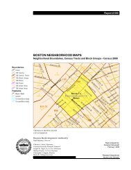
privately and publicly owned land. As shown in Figure 1-2, the Planning Area includes the<br />
land to be transferred from the MBTA, the DCAM and DND, as well as the privately owned<br />
parcels located at 1542 Columbus Avenue and 41 Amory Street. This area is shown in red<br />
in Figure 1-2.<br />
The Planning Area also includes the City of <strong>Boston</strong>’s Public Works Department<br />
Maintenance Facility adjacent to Marcella Park (“DPW Site”) and the privately owned<br />
NSTAR substation at the corner of Columbus Avenue and Centre Street. The DPW and<br />
NSTAR sites were not included in the RFP and are not controlled by the Project. This area<br />
is shown in blue in Figure 1-2.<br />
The environmental impact analyses for <strong>Jackson</strong> <strong>Square</strong> will include the entire Planning Area<br />
– both the parcels controlled by the proponent and the parcels controlled by others -- to<br />
show the greatest potential impact. The phasing plan for development of the site<br />
recognizes that certain portions of the Project site will be developed in later phases as<br />
ownership is clarified. The phasing is described in more detail in Section 2.2.1 of the <strong>PNF</strong>.<br />
Project Site<br />
The Project Site, shown in Figure 1-3, shows the land area which will be developed and<br />
controlled by the proponent when the Project has been fully built out, according to the<br />
proposed development plan. The Project Site land area will be approximately 9.1 acres.<br />
1772/<strong>PNF</strong>/ <strong>Jackson</strong> <strong>Square</strong> Page 1-6 Summary<br />
Epsilon Associates, Inc.
Legend<br />
Public-Private Parcels<br />
NSTAR & DPW Parcels<br />
Scale 1:4,800<br />
1 inch = 400 feet<br />
200 0 200 400<br />
Lamartine Street<br />
Feet<br />
G:\Projects2\MA\<strong>Boston</strong>\1772_<strong>Jackson</strong>_Sq\<strong>PNF</strong>\planning_area.mxd<br />
<strong>Jackson</strong> <strong>Square</strong><br />
Station<br />
T<br />
Centre Street<br />
SITE III<br />
Amory Avenue<br />
Heath Street<br />
SITE I<br />
Amory Street<br />
<strong>Jackson</strong> Street<br />
Columbus Avenue<br />
SITE II<br />
Highland Street<br />
Ritchie Street<br />
Academy Road<br />
Figure 1-3<br />
Aerial Locus - Existing Conditions:<br />
Public & Private Parcels/NSTAR & DPW Parcels<br />
<strong>Jackson</strong> <strong>Square</strong><br />
<strong>Boston</strong>, Massachusetts<br />
Marcella Street<br />
Basemap: 2003 Orthophotography, BWSC<br />
10/25/06
For ease of review, as shown in Figure 1-3, the Project Site is equal to the land in the<br />
Planning Area, minus the land area of the proposed new <strong>Jackson</strong> Street and the land area of<br />
the reconfigured DPW site. Unless otherwise noted, the Project Site definition and acreage<br />
will be used in this <strong>PNF</strong> whenever the overall size of the development is discussed.<br />
DPW Coordination<br />
As described earlier, the Planning Area includes the full extent of the DPW property. As<br />
part of the Project, the existing DPW salt shed will remain on the site but is proposed to be<br />
reconfigured and relocated adjacent to the existing DPW maintenance building to provide<br />
site access from Ritchie Street and reduce the impact of operations. The proponent has<br />
begun and will continue to coordinate with DPW to finalize this plan and ensure that DPW<br />
operations are not adversely affected during construction of the Project. This proposed<br />
activity on the DPW property, including its timing and coordination with other Project<br />
elements, is described in Section 2.2.<br />
Proposed Project<br />
The proposed Project involves the redevelopment of the Project Site, approximately 9.1<br />
acres of land located near the <strong>Jackson</strong> <strong>Square</strong> MBTA Station in the Jamaica Plain and<br />
Roxbury neighborhoods of <strong>Boston</strong>. Below is a brief description of the planning and urban<br />
design principles considered for the Project. Section 3.3 of the <strong>PNF</strong> provides more detail<br />
on Urban Design and Section 1.2.5 includes a list of Public Benefits.<br />
Planning Principles<br />
The <strong>Jackson</strong> <strong>Square</strong> Partners, LLC team envisions the new <strong>Jackson</strong> <strong>Square</strong> as a dynamic,<br />
diverse, pedestrian-oriented neighborhood center. The plan integrates a broad mix of<br />
program uses and building types to put the “<strong>Square</strong>” back in <strong>Jackson</strong> <strong>Square</strong>. The Project:<br />
♦ Emphasizes design on a human scale, establishing <strong>Jackson</strong> <strong>Square</strong> as a place to be<br />
experienced up close, not simply a place to pass through on the way to somewhere<br />
else;<br />
♦ Takes full advantage of its strategic location adjacent to the <strong>Jackson</strong> <strong>Square</strong> MBTA<br />
station, creating a model for mixed-income, mixed-use, sustainable transit-oriented<br />
development;<br />
♦ Rebuilds connections across Jamaica Plain and Roxbury where they have long been<br />
divided by rail and road, creating a new identity as a vibrant destination that<br />
celebrates, honors, and preserves the economic and cultural diversity of the<br />
neighborhood; and<br />
♦ Serves the community now living in the <strong>Jackson</strong> <strong>Square</strong> area, with an emphasis on<br />
supporting the youth and families in the neighborhood.<br />
1772/<strong>PNF</strong>/ <strong>Jackson</strong> <strong>Square</strong> Page 1-8 Summary<br />
Epsilon Associates, Inc.
Legend<br />
Project Boundary<br />
Scale 1:4,800<br />
1 inch = 400 feet<br />
200 0 200 400<br />
Lamartine Street<br />
Feet<br />
G:\Projects2\MA\<strong>Boston</strong>\1772_<strong>Jackson</strong>_Sq\<strong>PNF</strong>\planning_area.mxd<br />
<strong>Jackson</strong> <strong>Square</strong><br />
Station<br />
T<br />
Centre Street<br />
SITE III<br />
Amory Avenue<br />
Heath Street<br />
SITE I<br />
Amory Street<br />
<strong>Jackson</strong> Street<br />
Columbus Avenue<br />
SITE II<br />
Highland Street<br />
Ritchie Street<br />
Academy Road<br />
Figure 1-2<br />
Aerial Locus - Development Parcels<br />
<strong>Jackson</strong> <strong>Square</strong><br />
<strong>Boston</strong>, Massachusetts<br />
Marcella Street<br />
Basemap: 2003 Orthophotography, BWSC<br />
10/18/06
The design seamlessly integrates public and adjacent private parcels into a single,<br />
comprehensive development program. It is ambitious in its goals, but reflects realistic<br />
strategies for funding and development phasing.<br />
Design and Development Principles<br />
The Project’s Urban Design and Development Principles include:<br />
Establishing the heart of <strong>Jackson</strong> <strong>Square</strong> by taking full advantage of its location adjacent to a<br />
major transit site and re-establishing it as a traditional urban neighborhood center;<br />
Rebuilding Connections Across Columbus Avenue by distributing new programs and<br />
services across both sides of the street;<br />
Embracing Diversity by retaining and strengthening the cultural, ethnic, and economic<br />
diversity that is a hallmark of Jamaica Plain and Roxbury;<br />
Encouraging Active Open Space by taking full advantage of the many unbuildable<br />
easements to underscore making <strong>Jackson</strong> <strong>Square</strong> a true destination;<br />
Prioritizing Pedestrian Safety by creating wide sidewalks, ample street crossings with<br />
improved signalization and creating paths which follow natural walking desire lines;<br />
Creating a Transit oriented development (TOD) by creating mixed uses clustered around the<br />
station to generate transit and pedestrian trips throughout the day and improving access to<br />
the MBTA station; and<br />
Embracing Sustainability and Green Design by integrating sustainable design throughout the<br />
Project’s design, construction, operation and occupancy and taking a “green” project-wide<br />
approach to the critical issues of energy use, stormwater management and transportation<br />
alternatives. Additional information on Sustainable Design is included in Section 3.2.14.<br />
Program<br />
As previously described, the <strong>Jackson</strong> <strong>Square</strong> Partners team has developed a bold and<br />
ambitious proposal that seamlessly integrates public and private land into a single, coherent<br />
development plan. The Project delivers the community vision with substantial community<br />
benefits while balancing the realities of financial feasibility. It integrates a broad mix of<br />
program uses and building types to create a pedestrian-oriented neighborhood that puts the<br />
“<strong>Square</strong>” back in <strong>Jackson</strong> <strong>Square</strong>.<br />
Specifically, the Project includes:<br />
State-of-the-art youth and family facilities<br />
♦ A 19,800 square-foot youth and family center; and<br />
1772/<strong>PNF</strong>/ <strong>Jackson</strong> <strong>Square</strong> Page 1-10 Summary<br />
Epsilon Associates, Inc.
♦ 30,750 square feet of additional multipurpose indoor recreational space.<br />
A model mixed income, transit-oriented housing program<br />
♦ 429 new ownership and rental housing units, 159 units (37 percent) proposed as<br />
ownership units, and 270 units (63 percent) proposed as rental;<br />
♦ 250 permanently affordable units for families earning up to 80 percent of area median<br />
income; and<br />
♦ 39 permanently affordable units for moderate income families earning between 80 and<br />
110 percent of area median income.<br />
A broad mix of commercial uses to provide local goods and services<br />
♦ 67,700 square feet of ground floor retail space, emphasizing opportunities for small<br />
local businesses; and<br />
♦ 13,500 square feet of local non-profit office space.<br />
Substantial site improvements<br />
♦ 500 off-street and 128 on-street parking spaces; and<br />
♦ Creation of a new 1.5-acre open space and plaza.<br />
♦ Widening of sidewalks and improvements to streets to improve the pedestrian and<br />
bicycle experience.<br />
1.2.2 Project Site<br />
<strong>Jackson</strong> <strong>Square</strong> (“the Project”) includes the Project Site, approximately 9.1 acres of land in<br />
<strong>Boston</strong>’s Jamaica Plain and Roxbury neighborhoods (see Figure 1-3). The land is<br />
concentrated in three areas (“Site I,” “Site II,” and “Site III”) surrounding the existing <strong>Jackson</strong><br />
<strong>Square</strong> MBTA Station. Site I comprises approximately 1.4 acres and is bounded by<br />
Columbus Avenue to the east, the <strong>Jackson</strong> <strong>Square</strong> MBTA Station and bus lane to the west<br />
and Centre Street to the south. Site II comprises approximately 3.6 acres and is bounded by<br />
Columbus Avenue to the west, Ritchie Street to the south, the Marcella/Connolly Park to the<br />
east, and by Highland Street and the Roxbury Community College surface parking lot to the<br />
north. Site III, which comprises approximately 4.1 acres, is generally bounded by Centre<br />
Street to the north, Amory Street to the east, an MBTA easement to the west, and Amory<br />
Avenue to the south.<br />
Figure 1-4 shows both the Planning Area and Project Site. The preliminary location and<br />
proposed program for each of the sites is shown on Figure 1-5. Detailed plans for each site<br />
are included in Appendix A.<br />
1772/<strong>PNF</strong>/ <strong>Jackson</strong> <strong>Square</strong> Page 1-11 Summary<br />
Epsilon Associates, Inc.
1.2.3 Proposed Development<br />
The proposed Project includes the construction of multiple buildings and facilities in five<br />
general phases (“Early Start,” “Phase 1,” “Phase 2,” “Phase 3,” and “Phase 4”) over a period<br />
of six years between 2007 and 2013. Table 1-1 includes each phase, site, individual<br />
buildings, and program information. A more detailed description is included in<br />
Section 2.2.1, Building Program.<br />
1.2.4 Phase 1 Project Scope<br />
Phase 1 of the Project is designed to send the important message that the redevelopment of<br />
<strong>Jackson</strong> <strong>Square</strong> has begun. To signal the establishment of a new district, this phase includes<br />
projects on both sides of Columbus Avenue and represents approximately 30 percent of the<br />
total development program.<br />
The Phase 1 projects include the development of:<br />
♦ Building A (225 Centre Street): A mixed-use apartment and retail project with 94<br />
apartments and approximately 23,000 square feet of retail space;<br />
♦ Building B: The <strong>Jackson</strong> <strong>Square</strong> Youth and Family Center, a 19,810 square-foot<br />
recreation facility;<br />
♦ Building C (1562 Columbus Avenue): A mixed-use condominium and retail project<br />
with 42 units and approximately 15,000 square feet of retail space;<br />
♦ Building D (1542 Columbus Avenue): The existing Webb Building, a 13,500 squarefoot<br />
office space; and<br />
♦ Building J (Small Shop Retail): A 3,500 square-foot structure designed for small scale<br />
retailers.<br />
1772/<strong>PNF</strong>/ <strong>Jackson</strong> <strong>Square</strong> Page 1-14 Summary<br />
Epsilon Associates, Inc.
Table 1-1: Project Program<br />
Parcel /<br />
Building<br />
A 225 Centre<br />
Street<br />
Address GSF (w/o<br />
parking)<br />
B 1531 Columbus<br />
Avenue<br />
C 1562 Columbus<br />
Avenue<br />
D 1542 Columbus<br />
Avenue (Webb<br />
Building)<br />
E 1522 Columbus<br />
Avenue<br />
F 1542R<br />
Columbus<br />
Avenue<br />
G Parking Garage<br />
G<br />
H Ritchie Street<br />
I Highland<br />
Avenue<br />
129,050<br />
(166,250<br />
w/parking)<br />
19,810<br />
57,360<br />
13,500<br />
36,500<br />
19,800<br />
39,600<br />
30,750<br />
20,950<br />
Use Stories Maximum<br />
Height<br />
(feet)<br />
Mixed Use<br />
(Residential<br />
(64%)/Retail<br />
(14%)/Parking<br />
(22%))<br />
Community Center<br />
(Youth & Family<br />
Center)<br />
Mixed Use<br />
(Residential<br />
(75%)/Retail (25%))<br />
6<br />
Dwelling<br />
Units<br />
75 94<br />
(100%<br />
Rental)<br />
Parking Spaces Site Developer Phase<br />
Garage A<br />
(100); on street<br />
(25)<br />
I Mitchell Properties;<br />
Gravestar, Inc.<br />
3 55 -- use Garage A I Jamaica Plain NDC; Hyde<br />
<strong>Square</strong> Task Force<br />
5<br />
65 42 (100%<br />
Ownership)<br />
Garage G (28);<br />
on-street (5)<br />
Office 3 40 -- Garage G;<br />
on street (6)<br />
Residential<br />
Department of<br />
Youth Services<br />
(DYS)<br />
Parking<br />
Active Indoor<br />
Recreation Facility<br />
Maintenance (salt<br />
shed / DPW<br />
maintenance<br />
building)<br />
II Urban Edge; Gravestar,<br />
Inc.<br />
II<br />
Urban Edge 1<br />
4 45 34 (100%<br />
Rental)<br />
use Garage G II Urban Edge 4<br />
3 40 -- Garage G (6); II Urban Edge Early<br />
on-street (6)<br />
Start<br />
2 20 -- 123 II Urban Edge 4<br />
1.5 35 -- use Garage G II Urban Edge, Friends of<br />
Kelly Rink<br />
1 / 1.5 30 -- -- II <strong>Boston</strong> Department of<br />
Public Works<br />
1772/<strong>PNF</strong>/ <strong>Jackson</strong> <strong>Square</strong> Page 1-15 Summary<br />
Epsilon Associates, Inc.<br />
1<br />
1<br />
1<br />
4<br />
2
Table 1-1: Project Program (continued)<br />
Parcel /<br />
Building<br />
Address GSF (w/o<br />
parking)<br />
J 260 Centre<br />
Street<br />
K 50-70 <strong>Jackson</strong><br />
Street<br />
L 32 <strong>Jackson</strong><br />
Street<br />
M 15 <strong>Jackson</strong><br />
Street<br />
N Amory Street<br />
O 250 Centre<br />
Street<br />
P 240 Centre<br />
Street (NSTAR)<br />
Use Stories Height<br />
(feet)<br />
Dwelling Units Parking Spaces Site Developer Phase<br />
3,500 Small Shop Retail 1 20 -- on-street (4) III Jamaica Plain NDC;<br />
Gravestar, Inc.<br />
59,140 Residential<br />
26,080<br />
(111,030<br />
w/parking)<br />
38,800<br />
29,800<br />
89,200<br />
50,280<br />
Mixed Use (Residential<br />
(20%)/Retail<br />
(4%)/Parking (76%))<br />
Residential<br />
Mixed Use (Residential<br />
(77%)/Retail (23%))<br />
Mixed Use (Residential<br />
(90%)/Retail (10%))<br />
Mixed Use (Residential<br />
(86%)/Retail (14%))<br />
6<br />
4<br />
70 55 (65%<br />
Rental; 35%<br />
Ownership)<br />
Garage L (20);<br />
on street (20)<br />
45 16 Garage L<br />
(223); on street<br />
(25)<br />
5 55 36 (100%<br />
Rental)<br />
4<br />
5 to<br />
10<br />
6<br />
55 23 (100%<br />
Ownership)<br />
120<br />
75 (100%<br />
Ownership)<br />
75 54 (100%<br />
Rental)<br />
Garage L; onstreet<br />
(4)<br />
Garage L; onstreet<br />
(16)<br />
Garage L; onstreet<br />
(7)<br />
Garage L; onstreet<br />
(10)<br />
III Jamaica Plain NDC 2<br />
III Urban Edge 3<br />
III Mitchell Properties;<br />
Gravestar, Inc.<br />
III Jamaica Plain NDC;<br />
Gravestar, Inc.<br />
III Mitchell Properties;<br />
Gravestar, Inc.<br />
III tbd 4<br />
1772/<strong>PNF</strong>/ <strong>Jackson</strong><br />
<strong>Square</strong> Page 1-16 Summary<br />
Epsilon Associates, Inc.<br />
1<br />
3<br />
3<br />
3
Phase 1 also includes the development of related infrastructure and pedestrian safety<br />
improvements including new sidewalks, crosswalks, landscaping and signalization along<br />
segments of Centre Street, Columbus Avenue and Ritchie Street. The first phase also<br />
assumes the completion of specific work described in the Early Start Phase, which is<br />
described in Section 2.2.1 and Figure 2-1. Figure 1-6 shows the specific condition that will<br />
exist upon the completion of Phase 1. More detail on the building program and Project<br />
phasing can be found in Section 2.2, Project Description.<br />
1.2.5 Public Review / Process<br />
Submission of this Project Notification Form initiates Large Project Review under Article<br />
80B of the <strong>Boston</strong> Zoning Code. The subsequent Draft Project Impact Report (DPIR) will<br />
provide environmental analyses on the full development program as well as the public<br />
realm and infrastructure improvements for the entire Project. The DPIR will include urban<br />
design analysis of the full Master Plan area, discussion of interim site conditions between<br />
Project phases and architectural design of the Phase 1 projects. Subsequent phases of<br />
development will be included in the environmental and transportation analyses with the<br />
understanding that these later phases will undergo more extensive design review in<br />
accordance with the phasing schedule. Section 3.3, Urban Design, includes more detailed<br />
information about the design review process. It is expected that, at the completion of this<br />
Article 80 process, the Phase 1 projects will have completed all BRA reviews needed prior<br />
to obtaining a Building Permit (subject, of course, to the other required City and State<br />
permits).<br />
There is some work identified as Early Start projects that, to maintain Project schedule,<br />
should be initiated in 2007, potentially prior to completion of the Article 80 process. The<br />
proponent will work with the BRA to identify the appropriate mechanism for advancing<br />
those projects, which include the remediation of a portion of Site I, demolition and<br />
construction of the DYS facility, and construction of temporary access from Columbus<br />
Avenue to the DYS facility on Site II.<br />
1.2.6 Public Benefits<br />
The Project provides substantial public benefits to the residents of the City of <strong>Boston</strong>. The<br />
redevelopment effort will transform the <strong>Jackson</strong> <strong>Square</strong> area into a vibrant mixed use<br />
neighborhood that will increase the supply of housing, particularly affordable housing,<br />
develop brownfield sites, provide a sustainable, Transit Oriented Development, provide<br />
residents with increased safety, improved aesthetic appearance, greater recreational and<br />
social activities and enhanced commercial opportunities. Physical improvements such as<br />
new lighting, signage and plantings, as well as significant open space improvements and<br />
construction of much desired space for community facilities will help the neighborhood<br />
realize its full potential.<br />
1772/<strong>PNF</strong>/ <strong>Jackson</strong> <strong>Square</strong> Page 1-17 Summary<br />
Epsilon Associates, Inc.
Increased Housing<br />
The Project will provide 429 residential units, which is consistent with Mayor Menino’s<br />
goal, declared in Leading the Way II, of producing 10,000 new units of housing by 2007.<br />
The Project will promote the vibrant mixed-use, transit-oriented neighborhood that the City<br />
and community residents envision for this area.<br />
Affordable Housing<br />
The proponent is committed to maximizing affordable housing opportunities for families<br />
while developing <strong>Jackson</strong> <strong>Square</strong> as a truly mixed-income community. As such, the Project<br />
will significantly exceed Mayor Menino’s Executive Order on affordable housing dated<br />
May 16, 2006.<br />
The ambitious housing program for the Project integrates a mix of housing types, ownership<br />
models and income targets to provide a diversity of design and scale necessary to meet the<br />
City and community vision for the area. At 429 units (including the 54 units proposed for<br />
the NSTAR site), housing represents the largest single element of the program. The program<br />
includes a mix of ownership (37 percent) and rental (63 percent) housing. Of the total<br />
units, approximately 251 (59 percent) will be made affordable to households earning up to<br />
80 percent of the area median income (AMI), and an additional 39 units will be affordable<br />
to moderate income households (between 80 and 110 percent of AMI). The detailed<br />
housing program showing the number of units in each income bracket is shown in the table<br />
below:<br />
Table 1-2: Residential Units by Income and Tenure<br />
Income Rental Ownership Total<br />
Market 81 58 139<br />
< 110% AMI -- 39 39<br />
< 80% AMI -- 62* 62<br />
< 60% AMI 160 -- 160<br />
<strong>Jackson</strong> <strong>Square</strong> Planning Initiative / ”Putting the Pieces Together”<br />
The Project meets the goals of the community as expressed in the community vision<br />
prepared by the BRA and the specific requirements detailed in the RFP. These goals<br />
include over 200 units of affordable housing, community facilities for youth and families,<br />
and small-scale retail that will support and complement the existing retail in the<br />
Hyde/<strong>Jackson</strong> <strong>Square</strong> and Egleston <strong>Square</strong> districts.<br />
<strong>Boston</strong> Main Streets Initiative<br />
<strong>Boston</strong>’s Main Streets Initiative is a City economic development program aimed at<br />
promoting and sustaining the vitality of 19 designated neighborhood business districts<br />
around the City. Situated at a key crossroads between Jamaica Plain and Roxbury and<br />
between two <strong>Boston</strong> Main Streets districts – the Hyde/<strong>Jackson</strong> Main Street District in<br />
Jamaica Plain and the Egleston <strong>Square</strong> Main Street District in Roxbury - the addition of<br />
approximately 67,700 square foot of retail space in <strong>Jackson</strong> <strong>Square</strong> will complement and<br />
strengthen the Main Streets Initiative by bridging these two Main Streets districts,<br />
implementing a coordinated marketing effort to connect the new <strong>Jackson</strong> <strong>Square</strong> into the<br />
existing business district, and increasing the number of potential customers for the<br />
businesses in these Main Streets districts. The public benefit derived from the retail<br />
component will be further enhanced by a concerted effort to recruit local entrepreneurs as<br />
retail tenants, provide space for local and start-up businesses, and to craft an economic<br />
development program to support those start-ups. JSP has been working with these two<br />
Main Streets organizations throughout the planning process and subsequent to designation;<br />
this will continue through the permitting, development and leasing and management stages<br />
of the Project.<br />
Smart Growth Development<br />
The Project will leverage the <strong>Jackson</strong> <strong>Square</strong> area to create a thriving urban environment by<br />
replacing vacant and underutilized brownfields property surrounding <strong>Jackson</strong> <strong>Square</strong><br />
Station with a new, attractive mixed use sub-neighborhood. Located within a quarter-of-amile<br />
radius of the <strong>Jackson</strong> <strong>Square</strong> Station, this TOD will result in improved access for<br />
pedestrians and bicyclists to public transit by incorporating sidewalk, street and signage<br />
improvements that will contribute to reducing automobile dependency in the area and<br />
encourage greater use of public transit. Figure 1-7 illustrates the TOD nature of the Project.<br />
Open Space<br />
The Project presents a splendid opportunity to take full advantage of the unbuildable<br />
easements in the area and make improvements to existing area open spaces. As part of the<br />
Project, the proponent will develop an addition to the active Southwest Corridor park along<br />
the section of the MBTA easement that extends between Centre Street to the north and<br />
Amory Avenue to the south with generous walkways, bike paths, benches, site lighting and<br />
1772/<strong>PNF</strong>/ <strong>Jackson</strong> <strong>Square</strong> Page 1-20 Summary<br />
Epsilon Associates, Inc.
plantings, and a new plaza for community gatherings and events. The Project will also<br />
include improvements to the visual and physical connection to the Marcella/Connolly Park,<br />
and to the section of the existing parkway that extends between the <strong>Jackson</strong> <strong>Square</strong> Station<br />
and the northern section of Site I. In addition, benches, public art, landscaping, and<br />
lighting will be integrated to encourage walking, gathering, strolling, lingering, and<br />
meeting. Outdoor seating will be created adjacent to restaurants and cafes, as well as<br />
active, programmed outdoor space, such as community plaza, community market, and<br />
retail arcade, to encourage street activity.<br />
Improved Street and Pedestrian Environment<br />
With the construction of over 50,000 square feet of community facilities (i.e., Youth and<br />
Family Center and indoor recreation activity facility), planned street and sidewalk<br />
improvements, including new crosswalks, pedestrian “bump-outs” and median strips,<br />
nighttime lighting, attractive buildings facades, signage and plantings, the Project will foster<br />
pedestrian activity and contribute to the increased safety and vitality of the area throughout<br />
the day and evening.<br />
Sustainable Design / Green Building<br />
Principles of sustainability and green design guide the entire Project program to make<br />
<strong>Jackson</strong> <strong>Square</strong> a national model for “green” mixed-use, transit-oriented development.<br />
To reduce the “environmental footprint” of the Project, the proponent is committed to the<br />
ongoing integration of sustainable design throughout the Project’s design, construction,<br />
operation and occupancy. A multi-disciplinary “green team” of consultants is working with<br />
the proponent and the individual developers to identify and evaluate opportunities for<br />
integrating sustainability into the Project at both the master plan and individual project<br />
level.<br />
The Project will include multiple “green” buildings, in accordance with the City of <strong>Boston</strong>’s<br />
policy that new developments be certifiable under the U.S. Green Building Council’s<br />
Leadership in Energy and Environmental Design (LEED) standards. The commitment to<br />
sustainability extends well beyond the Project’s individual buildings. The Project will result<br />
in the remediation of contaminated sites; be located adjacent to a busy MBTA Orange Line<br />
and bus station; create a mixed-use, smart growth development that, in the words of the<br />
Commonwealth’s Sustainable Development principles, consists of “walkable districts<br />
mixing commercial, civic, cultural, educational and recreational activities with open space<br />
and housing for diverse communities,” provide residents, workers and visitors with<br />
transportation choices including walking, bicycling, and taking a bus or rapid transit;<br />
minimize energy use and greenhouse gas emissions by incorporating aggressive energy<br />
conservation measures and, if found to be feasible, by generating renewable energy to meet<br />
a portion of the development’s energy needs; incorporate the principles of low-impact<br />
development, by reducing stormwater runoff using a campus-wide strategy that may include<br />
1772/<strong>PNF</strong>/ <strong>Jackson</strong> <strong>Square</strong> Page 1-22 Summary<br />
Epsilon Associates, Inc.
use of pervious materials, green roofs, and cisterns and bioswales; conserve potable water<br />
supplies using techniques including water conservation measures and capture and reuse of<br />
rainwater on-site; and integrate open spaces, trees and sustainable landscaping to ensure<br />
that the Project’s density is balanced with green spaces. The Project’s sustainable Design<br />
principles are further described in Section 3.2.14.<br />
Economic Development<br />
Drawing from the JPNDC’s strong track record of supporting small business development<br />
and local employment, the Project will include the following economic development<br />
elements.<br />
Job creation: The Project is anticipated to create approximately 1,470 new construction<br />
jobs over the six-year construction period. When fully built out, the Project is estimated to<br />
generate 160 permanent positions. The permanent positions will result primarily from the<br />
proposed commercial component and from building maintenance. The proponent will<br />
provide a variety of training and recruitment activities to ensure opportunities for local<br />
residents.<br />
Small business development: The proponent will work with local Main Streets<br />
organizations and others to recruit and support retail establishments in the Project owned<br />
by local entrepreneurs. This effort will include the creation of small shop retail space which<br />
will be ideal for micro-enterprise development.<br />
Youth entrepreneurship: Programs run by the Hyde <strong>Square</strong> Task Force will focus on<br />
supporting start-up concepts of area youth.<br />
New Property Tax Revenue<br />
The Project will generate approximately $1.05 million in annual property taxes from the<br />
residential and the retail components.<br />
1.3 Consistency with Zoning<br />
1.3.1 Zoning Districts<br />
As shown on Figures 1-3 and 1-4, the Project Site is divided into three sub-areas, Site I, Site<br />
II and Site III, each of which is divided into individual development parcels containing<br />
buildings A through P. Site I and Site III are located within the Jamaica Plain Neighborhood<br />
District, governed by Article 55 of <strong>Boston</strong> Zoning Code. All of the buildings on Site I and<br />
Site III are located within the Neighborhood Shopping (NS) Subdistrict except that a portion<br />
of Parcel P is located in an Industrial Development Area (IDA) Subdistrict.<br />
1772/<strong>PNF</strong>/ <strong>Jackson</strong> <strong>Square</strong> Page 1-23 Summary<br />
Epsilon Associates, Inc.
All of Site II is located within the Community College (CC) Subdistrict of the Roxbury<br />
Neighborhood District, governed by Article 50 of the <strong>Boston</strong> Zoning Code.<br />
Portions of Site III, comprising Parcels J, K, L, M, N and O, are located in or abut the<br />
Southwest Corridor Greenbelt Protection Overlay District (GPOD) in Jamaica Plain. In<br />
addition, portions of Parcels C, D and E located within 100 feet of the center line of<br />
Columbus Avenue are located within the Columbus Avenue Boulevard Planning District in<br />
Roxbury.<br />
1.3.2 Permitted Uses<br />
The Project’s primary use, multi-family housing, is generally allowed as of right above the<br />
ground floor on the Project site; multi-family residential use is forbidden, however, within<br />
the portion of Parcel P located within the IDA subdistrict and on the ground floor and<br />
basement of buildings within the NS subdistrict. Ground-floor commercial uses are<br />
generally allowed as of right except on Site II, where they are forbidden. Some other<br />
potential ground-floor uses are either conditional or forbidden, based on the precise nature<br />
of these uses and their location on the Project site. The Youth and Family Center on<br />
Parcel B is an allowed use; the Division of Youth Services Detention Facility to be relocated<br />
to Parcel F is a conditional use. In addition, most accessory parking is an allowed use if on<br />
the surface or in the basement or ground floor of buildings. Parking above the ground floor<br />
is forbidden in the NS subdistrict. Ancillary parking uses are conditional in the NS<br />
subdistrict.<br />
1.3.3 Dimensional Requirements<br />
All of Site I and most of Site III, in the Jamaica Plain Neighborhood District, are subject to a<br />
60-foot height limit; portions of Parcels L, M, N, O and P are subject to a 45-foot height<br />
limit. All of Site II, in the Roxbury Neighborhood District, is subject to a 45-foot height<br />
limit. Proposed Project buildings range in height from approximately 20 feet to<br />
approximately 120 feet, with the prevailing building height being between 40 feet and<br />
60 feet. In general, there are no front or side yard requirements except that a 15-foot front<br />
yard requirement applies along Amory Street. A 20-foot rear yard requirement applies to<br />
the entire Project site.<br />
1.3.4 Floor Area Ratio<br />
Virtually the entire Project site, except for a portion of Parcel P, is subject to a maximum<br />
floor area ratio of 2.0. The total Project-wide floor area ratio of the Project is likely to be<br />
approximately 2.0. FARs for specific parcels will vary.<br />
1.3.5 Design Requirements<br />
The portion of the Project located within the Southwest Corridor GPOD would require a<br />
conditional use permit and will be subject to the Site Plan Component of Article 80 review.<br />
1772/<strong>PNF</strong>/ <strong>Jackson</strong> <strong>Square</strong> Page 1-24 Summary<br />
Epsilon Associates, Inc.
In addition, all portions of the Project will be subject to general and specific design<br />
requirements, screening and buffering requirements, and signage requirements.<br />
1.3.6 Off-Street Parking and Loading<br />
In both the Roxbury and Jamaica Plain Neighborhood Districts, off-street parking and<br />
loading requirements for projects subject to Large Project Review are determined in the<br />
course of Large Project Review. The proposed Project’s parking and loading facilities will<br />
also be subject to review through the zoning approval process selected by the proponent.<br />
The Project’s proposed off-street parking and off-street loading facilities are described in<br />
Section 3.1.7. A total of 500 accessory off-street parking spaces are proposed for the Project<br />
in parking garages on Parcels A, L and G, as well as surface parking on Parcels C and K.<br />
There will be additional new on-street parking spaces created on proposed <strong>Jackson</strong> Street<br />
abutting Parcels K, L, M and N. Loading activities will be accommodated in designated<br />
facilities on each of the three Project sites.<br />
1.3.7 Zoning Approval Mechanism<br />
The proponent is analyzing zoning options to address inconsistencies of the proposed<br />
master plan with the underlying zoning. The approach to zoning will be reviewed with the<br />
BRA and community during the Article 80 process. Based on current information, the<br />
proponent believes that the establishment of a “Master Plan PDA,” applicable only to<br />
projects with a minimum area of five acres, is the most appropriate approach. This would<br />
allow for a single, comprehensive zoning approval of all of the development sites and<br />
public realm improvements comprising the <strong>Jackson</strong> <strong>Square</strong> Project and would establish a<br />
development phasing schedule. If pursued, this would require approval by the <strong>Boston</strong><br />
<strong>Redevelopment</strong> <strong>Authority</strong>, the Zoning Commission and local neighborhood councils of a<br />
PDA Master Plan for the entire Project, along with PDA Development Plans for each phase<br />
as it proceeds, a companion map amendment to create a PDA overlay district and text<br />
amendment to make the Project site PDA-eligible.<br />
1.3.8 <strong>Boston</strong> Civic Design Commission Review<br />
The Project as a whole, which exceeds 100,000 square feet of gross floor area, will be<br />
subject to review by the <strong>Boston</strong> Civic Design Commission as a Large-Scale Development<br />
Project under Article 28 of the Code.<br />
1.3.9 Inclusionary Housing<br />
The Mayor’s Executive Order dated May 16, 2006 establishes as city policy that any<br />
residential project seeking zoning relief set aside at least 15 percent of its units as affordable<br />
to moderate-income and middle-income households or contribute to a housing creation<br />
fund a per-unit subsidy for 15 percent of the number of project units. The Project will<br />
significantly exceed the requirements of the Mayor’s Executive Order.<br />
1772/<strong>PNF</strong>/ <strong>Jackson</strong> <strong>Square</strong> Page 1-25 Summary<br />
Epsilon Associates, Inc.
1.3.10 Linkage<br />
Because the Project will contain less than 100,000 square feet of Development Impact<br />
Uses, it will not trigger jobs or housing linkage obligations under Article 80 of the Code.<br />
1.4 State Impact Reviews<br />
The Project as a whole is potentially subject to environmental impact review by the MEPA<br />
Unit of the Executive Office of Environmental Affairs, as well as to State Register Review by<br />
the Massachusetts Historical Commission. The proponent will separately submit an<br />
Environmental Notification Form to the MEPA Unit and to the Massachusetts Historical<br />
Commission, to initiate such reviews.<br />
1.5 Legal Information<br />
1.5.1 Legal Judgments<br />
The Proponent is not aware of any legal judgments in effect or legal actions pending that<br />
would prevent the proponent from undertaking the Project.<br />
1.5.2 History of Tax Arrears on Property<br />
Large portions of the Project site are owned by public agencies and are therefore exempt<br />
from local real estate taxes. Affiliates of Urban Edge, one of the members of <strong>Jackson</strong> <strong>Square</strong><br />
Partners, the Project proponent, owns parcels described in the following section,<br />
comprising portions of Site II and Site III. None of these parcels are in tax arrears to the City<br />
of <strong>Boston</strong>.<br />
1.5.3 Evidence of Site Control/Nature of Public Easements<br />
Portions of the Project site, with addresses of 1542 Columbus Avenue and 41 Amory Street,<br />
are owned by affiliates of the proponent or controlled through purchase options. Site I and<br />
portions of Site III are currently owned by the Massachusetts Bay Transportation <strong>Authority</strong>;<br />
much of Site III is currently owned by the Massachusetts Highway Department; and a<br />
portion of Site II is currently owned by the City of <strong>Boston</strong> Department of Neighborhood<br />
Development. Each of these public agencies has designated the <strong>Boston</strong> <strong>Redevelopment</strong><br />
<strong>Authority</strong> as its agent for purposes of disposition of these parcels. By Memorandum of<br />
Recommendation dated September 29, 2005, the proponent received a tentative<br />
designation to develop these publicly owned parcels. The proponent does not currently<br />
have site control over two parcels which are currently included in the Project’s Planning<br />
Area (as defined in Section 1.2). These locations are Site P, with an address at 240 Centre<br />
Street, currently owned by NStar, and Sites G and H, currently owned by the City of <strong>Boston</strong><br />
and used by the Public Works Department.<br />
1772/<strong>PNF</strong>/ <strong>Jackson</strong> <strong>Square</strong> Page 1-26 Summary<br />
Epsilon Associates, Inc.
1.6 Public Agencies<br />
The following table lists local, state and federal permits and approvals which may be<br />
required for the Project. Given the preliminary nature of Project design, this list is subject<br />
to change. This list also does not include public agency approvals related to property<br />
disposition and financing.<br />
Table 1-3: Anticipated Permits, Reviews and Approvals<br />
Agency Name Permit, Review or Approval<br />
FEDERAL<br />
United States Environmental Protection Agency National Pollution Discharge Elimination System<br />
STATE<br />
Executive Office of Environmental Affairs (MEPA Unit) Secretary’s Certificate<br />
Massachusetts Historical Commission State Register Review<br />
Department of Environmental Protection,<br />
Division of Water Pollution Control<br />
Sewer Connection and Extension Permit<br />
Massachusetts Water Resources <strong>Authority</strong> Sewer Use Discharge Permit<br />
LOCAL<br />
<strong>Boston</strong> <strong>Redevelopment</strong> <strong>Authority</strong> Article 80 Large Project Review;<br />
Planned Development Area Approval<br />
<strong>Boston</strong> Civic Design Commission Approval of Schematic Design<br />
<strong>Boston</strong> Zoning Commission Planned Development Area Approval<br />
<strong>Boston</strong> Transportation Department Transportation Access Plan Agreement;<br />
Construction Management Plan<br />
<strong>Boston</strong> Inspectional Services Department Building and Occupancy Permits<br />
<strong>Boston</strong> Water and Sewer Commission Sewer Extension/ Connection Permit;<br />
<strong>Boston</strong> Committee on Licenses Parking Garage License;<br />
Fuel Storage License<br />
Public Works Department/Public Improvement<br />
Commission<br />
Curb Cut Permits;<br />
Street Discontinuances and Acceptances;<br />
Specific Repairs<br />
<strong>Boston</strong> Parks Commission Approval of construction within 100 feet of a park<br />
1772/<strong>PNF</strong>/ <strong>Jackson</strong> <strong>Square</strong> Page 1-27 Summary<br />
Epsilon Associates, Inc.
2.0 PROJECT DESCRIPTION<br />
2.1 Existing Site<br />
The proposed Project will be located on approximately 9.1 acres of land in <strong>Boston</strong>’s<br />
Jamaica Plain and Roxbury neighborhoods, in the area surrounding the MBTA’s <strong>Jackson</strong><br />
<strong>Square</strong> Station.<br />
The Project area includes a mix of uses. Low- and mid-rise residential and commercial<br />
buildings, as well as community facilities, recreational open space, light-industrial<br />
operations, and vacant and underutilized parcels characterize the area. The Project has<br />
excellent access to MBTA rapid transit and bus service at the adjacent <strong>Jackson</strong> <strong>Square</strong><br />
station.<br />
2.2 Proposed Development Program<br />
2.2.1 Building Program<br />
The proposed Project includes a mixed-use sub-neighborhood that will replace a number of<br />
existing vacant and underutilized parcels in the area surrounding the <strong>Jackson</strong> <strong>Square</strong> MBTA<br />
Station.<br />
The Project program involves approximately 429 units (452,010 square feet) of housing,<br />
including approximately 251 units (58 percent) affordable to households earning up to 80<br />
percent of the AMI, and an additional 39 units affordable to moderate income households<br />
(earning less than 110 percent of the AMI). It also includes approximately 67,700 square<br />
feet of ground floor retail space located across all three sites that will complement and<br />
strengthen the array of existing businesses in the Egleston and Hyde/<strong>Jackson</strong> business<br />
districts and will be further enhanced by a concerted effort to recruit local entrepreneurs as<br />
retail tenants, provide space for local start-up businesses, and to craft an economic<br />
development program to support community residents. Also included, are approximately<br />
13,500 square feet of office space and approximately 50,600 square feet of community<br />
facilities, including a Youth and Family Center and an indoor active recreation facility. The<br />
Project also includes a new facility for the Department of Youth Services program currently<br />
located on Site II. In addition, the Project includes a number of streetscape, public<br />
infrastructure and open space improvements, as well as approximately 500 off-street and<br />
128 on-street spaces, which will be built in coordination with the projects in each phase.<br />
Project Phasing<br />
The Project phasing plans shown in Figures 2-1 through 2-4 depict initial thoughts<br />
concerning how the projects will be phased on the various sites and the development entity<br />
responsible for each project. The phasing plans reflect an integration of physical, financial<br />
1772/<strong>PNF</strong>/ <strong>Jackson</strong> <strong>Square</strong> Page 2-1 Project Description<br />
Epsilon Associates, Inc.
and market considerations. They also reflect the minimum requirements for physical<br />
improvements needed to achieve the identity and place making goals of <strong>Jackson</strong> <strong>Square</strong>.<br />
These Urban Design considerations are discussed in greater detail in Section 3.3.<br />
Prior to submitting the DPIR, the design and development teams will refine and expand this<br />
phasing plan. The infrastructure scope and funding sources will be further developed, with<br />
a goal of advancing the scope of the infrastructure beyond the ”minimum requirements”<br />
shown in the current phasing plans. The phasing plans will also address the ”interim<br />
conditions,” that is, the improvements that can be provided on the undeveloped site areas<br />
to ensure that at each phase of development, <strong>Jackson</strong> <strong>Square</strong> will look attractive and be<br />
safe.<br />
Early Start<br />
An early start, preparatory phase, is expected to commence in the third quarter of 2007 and<br />
be completed in the fourth quarter of 2008. The most significant part of the early start<br />
scope is the replacement of the existing Division of Youth Services (DYS) facility<br />
(Building F), which is currently located in an “ell” building attached to<br />
1542 Columbus Avenue; this “ell” must be demolished to allow for construction of the new<br />
retail/residential building (Building C). Temporary access, surface parking spaces and<br />
outdoor play space will be developed as part of the DYS facility. In addition, an early start<br />
to the environmental remediation of a portion of Site I will help ensure a timely start of the<br />
buildings on Site I.<br />
Phase 1<br />
Construction of Phase 1 is expected to commence in the second quarter of 2008 and be<br />
completed in the second quarter of 2010. Phase 1 must make a significant impact to<br />
establish the new <strong>Jackson</strong> <strong>Square</strong>. Thus, projects are planned on both sides of Columbus<br />
Avenue. On Site I, the Phase 1 program will include 94 apartments and 22,600 square feet<br />
of retail space, as well as the Youth and Family Center, plus associated parking and site<br />
improvements (Buildings A and B). The housing program is a mixed-income rental<br />
building, which is the most feasible way to develop a building of scale on this key parcel.<br />
On Site II, the Phase 1 program will include the creation of a mixed-use building on the<br />
corner of Columbus Avenue and Ritchie Street, with 14,600 square feet of retail space on<br />
the ground floor and 42 units of affordable and moderate income ownership housing<br />
above, introducing needed home ownership opportunities which are lacking in this area<br />
(Building C). With the relocation of DYS, the Webb Building will be fully renovated for<br />
office space (Building D). The Site II projects are planned to use surface parking on a<br />
temporary basis.<br />
1772/<strong>PNF</strong>/ <strong>Jackson</strong> <strong>Square</strong> Page 2-6 Project Description<br />
Epsilon Associates, Inc.
The development plan for Building C presented in this <strong>PNF</strong> requires use of a small portion<br />
of the adjacent DPW property, likely through an easement agreement. The coordination of<br />
the entire development plan with the existing DPW facility is discussed in detail below.<br />
Phase 1 also includes a small but significant retail component of Site III in the creation of a<br />
small shop retail building adjacent to the existing MBTA maintenance shed. This light<br />
structure is envisioned to accommodate relatively low per square foot rents, allowing access<br />
for local entrepreneurs and youth sponsored businesses.<br />
Phase 2<br />
Construction of Phase 2 is expected to commence in the third quarter of 2009 and be<br />
completed in the first quarter of 2011. The Phase 2 program involves construction of<br />
approximately 55 affordable ownership and rental units in a single six-story building<br />
(Building K) at the southern end of Site III. This building requires approximately 40 parking<br />
spaces which can be provided at the first level of the building and along the newly created<br />
<strong>Jackson</strong> Street, which is the key public infrastructure element in this phase. The phasing<br />
plans also show the development of at least part of the open space improvements that will<br />
be developed on the MBTA easement area. This open space component is shown to<br />
indicate that development of this linear open space is critical to this phase. It would be<br />
clearly preferable to develop the full extent of the open space, but the feasibility of doing so<br />
will depend on funding strategies.<br />
Phase 3<br />
Construction of Phase 3 is expected to commence in the first quarter of 2010 and be<br />
completed in the third quarter of 2013. Phase 3 involves approximately 150 residential<br />
units, approximately 20,100 square feet of retail and the completion of the Site III area. A<br />
single above-grade parking structure (Building L), which is ringed with 16 duplex<br />
townhouses and 4,000 square feet of retail, will provide parking for Site III. The balance of<br />
the residential and retail program in Phase 3, totaling approximately 134 housing units and<br />
approximately 16,100 square feet of ground floor retail, is provided in three buildings<br />
arranged around a shared courtyard. The building at 15 <strong>Jackson</strong> Street (Building M) will be<br />
an affordable four-story residential rental building with 36 units. Building N, along the<br />
extension of Amory Street, will be a 23-unit, mixed-income condominium building with<br />
small scale retail use on the ground floor. Finally, 250 Centre Street (Building O) will be a<br />
75-unit, mixed-income condominium. This signature building becomes feasible in this later<br />
phase once the previous development phases have established a market for it in <strong>Jackson</strong><br />
<strong>Square</strong> .<br />
Also projected for Phase 3 is the redevelopment of the DPW facility. Assuming a two-year<br />
construction schedule, starting this construction in Phase 3 allows time for planning and<br />
design for these structures, and also accommodates the schedule for Phase 4. Again, see<br />
the discussion below of DPW coordination.<br />
1772/<strong>PNF</strong>/ <strong>Jackson</strong> <strong>Square</strong> Page 2-7 Project Description<br />
Epsilon Associates, Inc.
Phase 4<br />
Phase 4 will complete the development of Site II. Construction of Phase 4 is expected to<br />
commence in the second quarter of 2011 and be completed in the third quarter of 2013.<br />
Building E includes 36 units of rental housing in a four-story building. Building H is the<br />
Active Indoor Recreation Facility. Buildings G provides centralized parking for the final<br />
build program on Site II.<br />
Also shown in Figure 2-4 is a proposed six-story mixed-use building on the NSTAR parcel.<br />
As discussed in the Urban Design section, development of this parcel is a critical<br />
component of completing the square. However, the proponent recognizes that there are<br />
substantial planning issues that must be addressed to relocate the existing sub-station. It<br />
may be appropriate to develop an interim plan for this parcel, especially for the paved and<br />
fenced area that forms the critical corner at Columbus Avenue and Centre Street.<br />
DPW Facility and Phasing<br />
The current plan for <strong>Jackson</strong> <strong>Square</strong> starts with the premise that the DPW must maintain a<br />
facility on its current site in <strong>Jackson</strong> <strong>Square</strong>. The intention of the plan is to present an<br />
alternative configuration that allows the DPW and the current and proposed uses in <strong>Jackson</strong><br />
<strong>Square</strong> to be better neighbors to each other. The current status of the DPW site is shown on<br />
Figure 2-5. The condition of the DPW site proposed for the Phase 1 development is shown<br />
on Figure 2-6. The reconfiguration concept which is currently being evaluated for the full<br />
build out of the Project is Shown on Figure 2-7. (The proponent plans to evaluate this<br />
scenario and other options in collaboration with DPW over the coming months).<br />
The proponent recognizes that there is much work that must be done to better understand<br />
DPW operations and work with DPW and community residents on alternatives that meet<br />
operating needs. Further, the proponent understands that any plan for reconfiguration must<br />
allow for uninterrupted sand and salt operations through the snow and ice season. The<br />
phasing plan presented is intended to allow the time for the proponent to work with DPW<br />
to develop plans that will meet all these goals.<br />
The Phase 1 plans, as shown in Figure 2-6, will require that a small portion of the existing<br />
DPW site be made available, likely through an easement, to provide access to Site II. The<br />
proposed location of the curb cut to Site II is located to stay clear of the busy Columbus<br />
Avenue/Centre Street/Ritchie Street intersection. Figure 2-6 shows the existing DPW<br />
configuration and the property that would be involved. The proponent believes this part of<br />
the site is not essential to DPW operations, but this assumption has not been reviewed or<br />
validated by DPW.<br />
The full reconfiguration of the DPW facility is not required to be completed until Phase 4 of<br />
the Project. To meet the current phasing schedule (Phase 4 construction start of 2011), the<br />
DPW construction work is shown to occur in Phase 3 (start 2009). This allows up to three<br />
1772/<strong>PNF</strong>/ <strong>Jackson</strong> <strong>Square</strong> Page 2-8 Project Description<br />
Epsilon Associates, Inc.
years for the planning, design and bidding of the eventually agreed upon plan. Further, the<br />
proponent recognizes that there are likely other configuration options that will accomplish<br />
the goals noted above, and is anxious to begin working closely with DPW on this matter.<br />
2.2.2 Approximate Dimensions<br />
Table 2-1 below presents the approximate dimensions of Project components:<br />
Table 2-1: Approximate Project Dimensions<br />
Project Element Dimension<br />
Project Site* 9.1 acres<br />
Residential Component 429 units / 452,010 sf<br />
Retail Component 67,700 sf<br />
Office 13,500 sf<br />
Youth and Family Center 19,810 sf<br />
Indoor Recreation 30,750 sf<br />
Department of Public Works (DPW) ** 20,950 sf<br />
<strong>Jackson</strong> Street Extension ** 33,000 sf<br />
Department of Youth Services (DYS) 19,800 sf<br />
Parking spaces 128 on-street<br />
500 off-street)<br />
* Total acreage for the three sites; not including planning area streets and DPW property.<br />
** Included in the planning area but not part of the Project.<br />
Figures 2-8, through 2-13 show the massing and renderings of the proposed Project.<br />
2.3 Planning Context<br />
The proposed Project will be situated at a key crossroads between Jamaica Plain and<br />
Roxbury, in the area surrounding the MBTA <strong>Jackson</strong> <strong>Square</strong> Station.<br />
1772/<strong>PNF</strong>/ <strong>Jackson</strong> <strong>Square</strong> Page 2-12 Project Description<br />
Epsilon Associates, Inc.
Figure 2-10<br />
Columbus Avenue Looking Southwest at Site I<br />
<strong>Jackson</strong> <strong>Square</strong><br />
<strong>Boston</strong>, Massachusetts
Figure 2-11<br />
Corner of Columbus Avenue and Ritchie Street Looking Northeast at Site II<br />
<strong>Jackson</strong> <strong>Square</strong><br />
<strong>Boston</strong>, Massachusetts
Figure 2-12<br />
<strong>Jackson</strong> <strong>Square</strong> Station Looking South at Site III<br />
<strong>Jackson</strong> <strong>Square</strong><br />
<strong>Boston</strong>, Massachusetts
Figure 2-13<br />
Centre Street Looking Southwest at Site III<br />
<strong>Jackson</strong> <strong>Square</strong><br />
<strong>Boston</strong>, Massachusetts
The area is densely populated and is one of the most diverse neighborhoods in <strong>Boston</strong>.<br />
Predominantly residential, the area is characterized by residential buildings of between one<br />
and nine stories, including the Academy Homes I and II, Bromley-Heath and the Amory<br />
Street elderly housing developments, which provide housing solutions to a variety of<br />
households. Vibrant and dynamic commercial zones can be found nearby on Centre Street<br />
(Hyde/<strong>Jackson</strong> Main Streets District) and Columbus Avenue (Egleston <strong>Square</strong> Main Streets<br />
District), with many locally owned businesses. The area is also characterized by some light<br />
industrial and warehouse facilities, as well as vacant and underutilized property, surface<br />
parking lots and some recreational open space (e.g., South Corridor Park and<br />
Marcella/Connolly Park).<br />
2.4 Schedule<br />
Project construction will be in five phases over a period of six years between 2007 and<br />
2013. Construction of Phase 1 is expected to commence in 2008 and to be completed in<br />
2010. Construction of Phase 2 is expected to begin in the fall of 2009 and to be completed<br />
in 2011. Construction of Phase 3 is expected to commence in early 2010 and to be<br />
completed in 2013, and construction of Phase 4 is expected to commence in 2011 and to<br />
be completed in 2013.<br />
1772/<strong>PNF</strong>/ <strong>Jackson</strong> <strong>Square</strong> Page 2-19 Project Description<br />
Epsilon Associates, Inc.
3.0 ASSESSMENT OF DEVELOPMENT REVIEW COMPONENTS<br />
Article 80 of the <strong>Boston</strong> Zoning Code specifies that the BRA may require in its Scoping<br />
Determination that the applicant conduct studies to determine the direct or indirect impact<br />
to the environment reasonably attributable to a proposed project. The development review<br />
components include transportation, environmental protection, urban design, historic<br />
resources, and infrastructure systems. Where potential for direct or indirect impacts exists,<br />
design measures may be required to mitigate the impacts, to the extent economically<br />
feasible. The areas for which studies and mitigation may be required are addressed below.<br />
3.1 Transportation<br />
3.1.1 Introduction<br />
This section presents existing transportation conditions in the Project area and discusses<br />
preliminary Project trip generation figures, preliminary transportation impacts, and<br />
measures associated with proposed redevelopment of the <strong>Jackson</strong> <strong>Square</strong> Development<br />
Area. A comprehensive analysis of transportation aspects of the Project, including<br />
pedestrian, transit, automobile traffic, parking, and loading activity will be prepared in<br />
cooperation with the <strong>Boston</strong> Transportation Department (BTD), the BRA, and the<br />
community.<br />
3.1.2 Project Description<br />
The Project involves redevelopment of the Project Site, approximately 9.1 acres of public<br />
and private land in <strong>Jackson</strong> <strong>Square</strong> on Centre Street, Ritchie Street, Amory Street, and<br />
Columbus Avenue into a transit-oriented, mixed-use development. The Project<br />
development area consists of three primary sites encompassing the northeast (Site I),<br />
northwest (Site II), and southwest (Site III) corners of <strong>Jackson</strong> <strong>Square</strong>. The proposed land<br />
uses by site are summarized in Table 3-1.<br />
Table 3-1: New Project Land Uses*<br />
Quantity/Size by Site<br />
Use Site I Site II Site III Combined<br />
Apartments (units) 94<br />
Land Uses<br />
34 142 270<br />
Condominiums (units) — 42 117 159<br />
Office (ksf) — 9.0 — 9.0<br />
Indoor Recreation (ksf) — 30.8 — 30.8<br />
Retail (ksf) 22.6 14.6 30.5 67.7<br />
Youth and Family Center<br />
(ksf)<br />
19.8 — — 19.8<br />
* Includes only “new“ land uses added to the Project sites that will have an impact on the existing<br />
transportation network. The existing Division of Youth Services Building, City of <strong>Boston</strong><br />
Maintenance Facility, and Webb Office Building will remain with the Project in place.<br />
1772/<strong>PNF</strong>/ <strong>Jackson</strong> <strong>Square</strong> Page 3-1 Assessment of Development Review Components<br />
Epsilon Associates, Inc.
The Project consists of creation of 429 residential units, including 270 rental apartments<br />
and 159 condominiums, approximately 50,600 square feet (sf) of community and<br />
recreational space, approximately 9,000 sf of new office space, and 67,700 sf of retail<br />
space. New streets and land parcels will also be created, along with off-street parking for<br />
approximately 500 vehicles and 128 new on-street parking spaces.<br />
With the Project in place, the existing City of <strong>Boston</strong> maintenance facility and the Division<br />
of Youth Services office space in the so-called Webb Building at 1542 Columbus Avenue<br />
will remain on Site II but may potentially be relocated or reconfigured on-site. The Webb<br />
Building will remain in its existing location.<br />
A detailed phasing plan for the construction of the proposed uses and associated<br />
infrastructure improvements will be developed in coordination with the City and<br />
neighborhood and will be discussed in detail in the DPIR.<br />
3.1.3 Site Access<br />
The Project is located adjacent to the <strong>Jackson</strong> <strong>Square</strong> MBTA station that has the Orange<br />
Line, bus, and private shuttle bus services. Sidewalk and street crossing improvements<br />
throughout <strong>Jackson</strong> <strong>Square</strong> will enhance pedestrian connections between <strong>Jackson</strong> <strong>Square</strong><br />
station and both the existing and proposed mixed uses in the area.<br />
Vehicles will access Site I via two entrances along Columbus Avenue that will also provide<br />
access to the at-grade parking garage. The northern access point will share the existing<br />
MBTA bus entryway and provide two-way, shared access up to the Site I garage opening,<br />
after which it will become a one-way driveway for buses only. The second access point on<br />
Columbus Avenue will be located between the existing MBTA bus entryway and Centre<br />
Street. Pedestrians will access the buildings on Site I via landscaped walkways surrounding<br />
the building, with connections to the MBTA <strong>Jackson</strong> <strong>Square</strong> station, Columbus Avenue, and<br />
the adjacent Southwest Corridor Bicycle Path.<br />
Vehicles will access Site II via Ritchie Street and Columbus Avenue. An internal driveway<br />
will provide continuous access between the two access points and throughout the parking<br />
area. In addition, a pick-up/drop-off area will be provided off Ritchie Street for the indoor<br />
recreation facility. Walkways throughout the site will facilitate pedestrian connections<br />
between the proposed buildings and <strong>Jackson</strong> <strong>Square</strong>.<br />
As part of the redevelopment of Site III, Amory Street will be extended to intersect with<br />
Centre Street approximately 225 feet west of Columbus Avenue. Amory Street will provide<br />
one-way northbound vehicular access between proposed <strong>Jackson</strong> Street and Centre Street<br />
and will remain two-way south of proposed <strong>Jackson</strong> Street. Only right turns will be allowed<br />
onto Centre Street from Amory Street. Vehicles will access the Site III parking garage via<br />
Amory Street. Similar to Sites I and II, sidewalk and walkway amenities throughout Site III<br />
will be improved to enhance the pedestrian environment. Pedestrian access to the Site III<br />
1772/<strong>PNF</strong>/ <strong>Jackson</strong> <strong>Square</strong> Page 3-2 Assessment of Development Review Components<br />
Epsilon Associates, Inc.
esidential units will be from the proposed <strong>Jackson</strong> Street. A proposed multi-use path on<br />
the MBTA easement between proposed <strong>Jackson</strong> Street and the tracks will provide off-street<br />
connections to the MBTA and Centre Street. Sidewalks will also be constructed along both<br />
sides of the new extension of Amory Street.<br />
3.1.4 Trip Generation<br />
The trip generation for the proposed Project was based on data contained in the Institute of<br />
Transportation Engineers (ITE) publication Trip Generation, 7th Edition (2003), which<br />
contains empirical data describing the trip generation characteristics for a wide variety of<br />
land use categories. The trip generation for the proposed uses is then determined by<br />
identifying comparable land use categories, as defined by ITE. Although they do not<br />
correspond exactly, the following ITE land use codes provide the closest match to the<br />
proposed land uses and were therefore used to estimate Project trips:<br />
Land Use Code 220—Apartment. Apartments are rental dwelling units located within the<br />
same building with at least three other dwelling units—for example, quadraplexes and all<br />
types of apartment buildings. The apartments in this land use include both low-rise “walkup”<br />
dwellings and high-rise, multi-family dwellings.<br />
Land Use Code 230—Residential Condominium. Residential condominiums are units with<br />
single-family ownership that have at least one other single-family-owned unit with the same<br />
building structure. Calculation of the number of trips uses ITE’s average rate per dwelling<br />
unit.<br />
Land Use Code 465—Ice Skating Rink. An ice skating rink is a stand-alone facility used for<br />
ice-skating sports and entertainment activities. It may contain limited spectator seating,<br />
refreshment areas, locker rooms and arcades. Due to the limited number of observations<br />
for this use, ITE did not provide data for the a.m. peak hour. Therefore, a morning peakhour<br />
trip generation rate was constructed using data from a comparable land use code:<br />
LUC 491—Racquet/Tennis Club.<br />
Land Use Code 495—Recreational Community Center. A recreational community center is<br />
a stand-alone public facility, similar to and including YMCAs, that often accommodates<br />
classes and clubs for adults and children, a day care or nursery school, meeting rooms,<br />
swimming pools and whirlpools, saunas; tennis, racquetball, handball, basketball, and<br />
volleyball courts, outdoor athletic fields/courts, exercise classes, weightlifting and<br />
gymnastics equipment, locker rooms, and a restaurant or snack bar. This land use code was<br />
used to determine the trip generation for the Youth and Family Center on-site.<br />
Land Use Code 820—Shopping Center. A shopping center is an integrated group of<br />
commercial establishments planned, developed, owned, and managed as a unit. A<br />
shopping center’s composition is related to its market area in terms of size, location, and<br />
type of store. Due to the residential nature of the area surrounding the Project site, the<br />
1772/<strong>PNF</strong>/ <strong>Jackson</strong> <strong>Square</strong> Page 3-3 Assessment of Development Review Components<br />
Epsilon Associates, Inc.
etail component of this Project will provide neighborhood services (e.g., goods and<br />
services such as general merchandise, pharmacy, convenience items such as<br />
newsstand/coffee and specialty items) and will be a complement to and continuation of the<br />
adjacent business district on Centre Street. These uses are not intended to be a destination<br />
retail type of use and will be less intense than a “shopping center,” as defined in ITE’s LUC<br />
820. They will therefore produce a conservatively high estimate of the associated trip<br />
generation.<br />
Mode split was derived from 2000 U.S. Census data (Tracts 812, 813, 1205) for this area<br />
and BTD data for Areas 5 and 6. The ITE rates produce vehicle trip estimates, which are<br />
then converted to person trips. Using the corresponding mode split data, shown in<br />
Table 3-2, the person trips are then reallocated to vehicle, transit, and walk/bike trips.<br />
Table 3-2: Peak-hour Mode Split<br />
Land Use Bike/Walk Transit Auto<br />
Residential 10% 35% 55%<br />
Indoor Recreation 37% 24% 39%<br />
Retail 37% 24% 39%<br />
Youth and Family Center 37% 24% 39%<br />
Based on the land use trip rates and mode split assumptions described above, Table 3-3<br />
summarizes the resulting Project-generated vehicle trips by site.<br />
Table 3-3: Vehicle Trip Generation<br />
Direction Site I Site II Site III Total<br />
Daily<br />
In 400 401 643 1,444<br />
Out 400 401 643 1,444<br />
Total 800 802 1,286 2,888<br />
Morning Peak Hour<br />
In 17 18 18 53<br />
Out 28 23 59 110<br />
Total 45 41 77 163<br />
Afternoon Peak Hour<br />
In 36 36 70 142<br />
Out 33 36 45 114<br />
Total 69 72 115 256<br />
As shown, estimated daily vehicle trips to and from the Project total about 2,888, with<br />
1,444 trips in and 1,444 trips out. In the morning peak hour, an estimated 53 vehicle trips<br />
in and 110 vehicle trips out will occur in the afternoon peak hour, 142 vehicle trips in and<br />
114 vehicle trips out will occur. The Project trips will be dispersed among the three sites.<br />
1772/<strong>PNF</strong>/ <strong>Jackson</strong> <strong>Square</strong> Page 3-4 Assessment of Development Review Components<br />
Epsilon Associates, Inc.
3.1.5 Public Transportation<br />
The Project is located adjacent to the MBTA <strong>Jackson</strong> <strong>Square</strong> station, where passengers may<br />
access MBTA rapid transit and bus services. As shown in Table 3-4, the Project will<br />
generate about 2,672 new daily transit trips (1,336 boarding and 1,336 alighting), with 140<br />
new transit trips during the morning peak hour (89 boarding and 51 alighting) and 237 new<br />
transit trips during the afternoon peak hour (110 boarding and 127 alighting).<br />
Table 3-4: Transit Trip Generation<br />
Direction Site I Site II Site III Total<br />
Daily<br />
In 383 396 557 1,336<br />
Out 383 396 557 1,336<br />
Total 766 792 1,114 2,672<br />
Morning Peak Hour<br />
In 17 18 16 51<br />
Out 24 19 46 89<br />
Total 41 37 62 140<br />
Afternoon Peak Hour<br />
In 33 35 59 127<br />
Out 32 37 41 110<br />
Total 65 72 100 237<br />
3.1.6 Pedestrian Circulation<br />
On a daily basis, the proposed Project will generate approximately 2,618 new pedestrian<br />
trips, including walk and bicycle trips, and an additional 2,672 new transit trips that require<br />
a walk to or from the site. This results in an additional 5,290 new pedestrian trips per day.<br />
The pedestrian trip generation for the Project is summarized in Table 3-5.<br />
Table 3-5: Pedestrian Trip Generation<br />
Direction Site -I Site II Site III Total<br />
Daily<br />
In 424 460 425 1,309<br />
Out 424 460 425 1,309<br />
Total 848 920 850 2,618<br />
Morning Peak Hour<br />
In 64 19 12 95<br />
Out 80 14 18 112<br />
Total 144 33 30 207<br />
Afternoon Peak Hour<br />
In 31 38 39 108<br />
Out 39 43 36 118<br />
Total 70 81 75 226<br />
1772/<strong>PNF</strong>/ <strong>Jackson</strong> <strong>Square</strong> Page 3-5 Assessment of Development Review Components<br />
Epsilon Associates, Inc.
As shown in the table, the Project will result in a significant increase in pedestrian traffic in<br />
the vicinity of <strong>Jackson</strong> <strong>Square</strong>. As a result, the Project includes a number of measures to<br />
improve pedestrian conditions throughout, and within, the vicinity of the site to<br />
accommodate and encourage additional pedestrian traffic.<br />
The study team will conduct a comprehensive review of the pedestrian conditions adjacent<br />
to the site and work with BRA, BTD, and the community to develop recommendations for<br />
pedestrian safety and circulation improvements. Mitigation measures associated with the<br />
Project are discussed in Section 3.1.10.<br />
3.1.7 Parking<br />
The Project will provide 500 off-street parking spaces (442 net new), located throughout the<br />
three sites, as summarized in Table 3-6; approximately 58 spaces will be replacement<br />
parking for MBTA employees’ parking spaces displaced by Site I construction and existing<br />
DYS and office users’ parking spaces on Site II. There will be 128 on-street spaces. Parking<br />
for the Project is consistent with BTD guidelines for transit-oriented development in Jamaica<br />
Plain (0.75 to 1.25 spaces per unit residential and 0.75 to 1.25 spaces per 1,000 sf nonresidential).<br />
For the DPIR, a detailed parking plan will be developed outlining the phased<br />
construction of on-site parking.<br />
Table 3-6: Parking Summary<br />
Site On-street Off-street 1<br />
Combined<br />
1 25 100 125<br />
2 17 157 174<br />
3 86 243 329<br />
Total 128 500 628<br />
1 Includes 58 existing parking spaces for the DYS and Webb office uses (30<br />
spaces) and the MBTA lot (28 spaces). These are not new spaces and will be<br />
relocated on-site with the Project.<br />
3.1.8 Loading and Service<br />
Recycling, trash collection, and loading activities will occur on-site in designated areas<br />
within each of the three Project sites to the extent possible. Where possible, trash and<br />
recycling for the residential units will be wheeled to the street for City of <strong>Boston</strong> pickup.<br />
Whenever possible, loading and service activities will take place during off-peak hours.<br />
Permanent “No Idling” signs will be posted in the loading and parking areas.<br />
3.1.9 Study Area<br />
Detailed analysis of intersection operations and development of appropriate mitigation<br />
measures will be addressed by the proponent. Impacts that require mitigation will be<br />
1772/<strong>PNF</strong>/ <strong>Jackson</strong> <strong>Square</strong> Page 3-6 Assessment of Development Review Components<br />
Epsilon Associates, Inc.
carefully coordinated with BTD as well as with neighbors, and the proponent will<br />
coordinate with BTD especially regarding BTD’s planned work on Centre Street west of the<br />
Project area.<br />
To evaluate both existing and future conditions, the proponent proposes to study the<br />
following intersections (see Figure 3-1):<br />
♦ Centre Street/Columbus Avenue/Ritchie Street;<br />
♦ Columbus Avenue/Centre Street/Heath Street;<br />
♦ Columbus Avenue/Cedar Street;<br />
♦ Centre Street/Lamartine Street;<br />
♦ Centre Street/MBTA Bus Exit;<br />
♦ Columbus Avenue/Dimock Street<br />
♦ Columbus Avenue/Amory Street; and<br />
♦ Highland Street/Department of Public Works (DPW) Driveway.<br />
Vehicle and pedestrian counts will be conducted at the above-listed study area intersections<br />
during the weekday morning (7:00–9:00 a.m.) and afternoon (4:00–6:00 p.m.) peak<br />
periods. These traffic counts will serve as a base scenario for the traffic analysis to be<br />
presented in the subsequent analysis.<br />
The proponent will coordinate with BRA and BTD to identify an appropriate study area,<br />
build year, growth rate, and any area development projects.<br />
3.1.10 Mitigation<br />
The proponent will work with BRA, BTD, and the community to identify measures that will<br />
improve the pedestrian environment in and around <strong>Jackson</strong> <strong>Square</strong>. Such measures may<br />
include the following:<br />
♦ Roadway Narrowing – Centre Street and Columbus Avenue will be narrowed in the<br />
vicinity of the <strong>Jackson</strong> <strong>Square</strong> intersection to allow for a shorter crossing distance for<br />
pedestrians. Roadway narrowing will be achieved by the provision of on-street parking<br />
and/or neckdowns.<br />
♦ On-street Parking – The provision of additional on-street parking within <strong>Jackson</strong> <strong>Square</strong><br />
will help create a buffer along Centre Street and Columbus Avenue, which will help<br />
improve the pedestrian environment in the area. Additionally, on-street parking will<br />
benefit the vitality of both the existing and the proposed retail and office uses.<br />
1772/<strong>PNF</strong>/ <strong>Jackson</strong> <strong>Square</strong> Page 3-7 Assessment of Development Review Components<br />
Epsilon Associates, Inc.
N<br />
Not to Scale.<br />
<strong>Jackson</strong> <strong>Square</strong> <strong>Redevelopment</strong><br />
Figure 3-1<br />
Study Area Intersections<br />
Project Notification Form
♦ Neckdowns – Neckdowns are extensions of the curb or sidewalk that help reduce<br />
pedestrian crossing distance, improve the visibility of pedestrians, physically eliminate<br />
parking within the close vicinity of an intersection, and provide a visual narrowing of<br />
the vehicle travel lanes—thus reducing vehicle speeds and increasing pedestrian safety.<br />
♦ Southwest Corridor Bike Path Improvements – The bike path crossing at Centre and<br />
Lamartine streets is indirect and creates conflicts between cyclists and pedestrians as<br />
they share a narrow 8-foot sidewalk on the north side of Centre Street. A more direct<br />
crossing would be implemented.<br />
♦ New Greenway Multi-Use Path – A new multi-use path will be established on the east<br />
side of the MBTA tracks adjacent to proposed <strong>Jackson</strong> Street. Ideally, that path would<br />
run from Centre Street to Atherton Street; however, the current plan only incorporates a<br />
path that extends to Amory Street.<br />
♦ Sidewalk Improvements – Sidewalks within the vicinity of the Project sites will be<br />
reconstructed and widened, where possible, to allow for increased pedestrian flows and<br />
larger storage areas adjacent to crosswalk locations. Wider sidewalks will also facilitate<br />
the addition of landscaping, benches, street lighting, and other amenities that would<br />
improve the pedestrian environment.<br />
♦ High-visibility or Textured Pavement – The proponent will evaluate the feasibility of<br />
providing high-visibility or textured pavement along Centre Street adjacent to the<br />
<strong>Jackson</strong> <strong>Square</strong> station and at the intersection of Centre Street/Columbus Avenue/Ritchie<br />
Street. In the vicinity of the <strong>Jackson</strong> <strong>Square</strong> Station, the proponent will work with BTD<br />
and the community to evaluate the appropriateness of adding a speed table. Providing<br />
a continuous raised section, rather than two consecutive crosswalks, would be an<br />
effective measure to remind motorists that they are in a pedestrian zone. Similarly,<br />
special pavement or pavement markings would be an effective measure to reduce<br />
vehicle driving speeds, improve safety, and enhance driver awareness of the pedestrian<br />
environment.<br />
♦ Amory Street Extension and Reconstruction – Amory Street will be extended between<br />
the proposed <strong>Jackson</strong> Street and Centre Street to provide improved pedestrian and<br />
vehicular access to Site III and to break up the feeling of a superblock.<br />
♦ Signal Improvements – Signals will be upgraded and coordinated as part of the Project,<br />
including a proposed new signal at the MBTA entranceway on Columbus Avenue.<br />
♦ A detailed construction phasing plan will be developed in close coordination with the<br />
City and neighborhood and provided in the DPIR.<br />
1772/<strong>PNF</strong>/ <strong>Jackson</strong> <strong>Square</strong> Page 3-9 Assessment of Development Review Components<br />
Epsilon Associates, Inc.
3.1.11 Transportation Demand Management<br />
The proponent is committed to implementing Transportation Demand Management (TDM)<br />
measures to minimize automobile usage and Project traffic impacts. The TDM program<br />
may include transit pass subsidies for employees, secure bicycle parking areas, and<br />
distribution of transit maps and schedules to residents, guests, and employees. TDM<br />
measures will be described and evaluated in the DPIR, which will be submitted to BRA,<br />
and Transportation Access Plan Agreement (TAPA), which will be submitted to BTD.<br />
3.1.12 Construction-period Impacts<br />
<strong>Jackson</strong> <strong>Square</strong> has an abundance of vacant land that could be used for construction staging<br />
areas to minimize impacts on pedestrian and vehicular traffic. A Construction Management<br />
Plan (CMP) executed with BTD will describe the need to occupy lanes of surrounding<br />
streets during construction and discuss measures for minimizing negative impacts<br />
associated with trucking activity and construction worker parking, including demand<br />
management for construction workers. The DPIR will include a detailed CMP for Phase 1.<br />
For subsequent phases, CMPs will be developed in coordination with BTD.<br />
3.2 Environmental Protection<br />
3.2.1 Wind<br />
The Project is not expected to cause significant impacts to pedestrian level winds. The<br />
Project will be of similar scale to the buildings along Columbus Avenue, Centre Street and<br />
other streets in the surrounding area. With a maximum building height of 80 feet in Site I,<br />
64 feet in Site II, and 120 feet in Site III, the Project will not result in a vertical deflection of<br />
upper level winds, which can result from buildings of 300 feet or more in height.<br />
3.2.2 Shadow<br />
The Project will be surrounded by and adjacent to structures of similar height and massing.<br />
Some of the properties included in the proposed Project are currently vacant. While the<br />
Project will result in increased shadow in the area, it is not anticipated to result in<br />
significant new shadow on surrounding public open spaces, public ways and building<br />
facades. The proponent will conduct a shadow study for the Project and report the results<br />
in the DPIR.<br />
3.2.3 Daylight<br />
The purpose of a daylight analysis is to estimate the extent to which a proposed project<br />
affects the amount of daylight reaching public streets in the immediate vicinity of the<br />
Project site. Due to the width of Columbus Avenue and the height of the proposed<br />
buildings, it is anticipated that daylight impacts will be minimal.<br />
1772/<strong>PNF</strong>/ <strong>Jackson</strong> <strong>Square</strong> Page 3-10 Assessment of Development Review Components<br />
Epsilon Associates, Inc.
3.2.4 Solar Glare<br />
It is not anticipated that the Project will include the use of reflective glass or other reflective<br />
materials on the building facades that would result in adverse impacts from reflected solar<br />
glare form the Project. Should reflective glass or other reflective materials be proposed as<br />
the Project design advances, the proponent will undertake a solar glare study as<br />
appropriate.<br />
3.2.5 Air Quality<br />
Potential long-term air quality impacts will be limited to emissions from Project-related<br />
mechanical equipment and pollutant emissions from vehicular traffic generated by the<br />
development of the Project. If changes in traffic operations are significant, the potential air<br />
quality impacts will be modeled for both existing and future conditions in the DPIR to<br />
demonstrate conformance with the National Ambient Air Quality Standards. Additionally,<br />
the DPIR analysis will determine whether the MBTA vent stack located on Site I will have to<br />
be modified due to the proximity of the proposed Building B.<br />
Construction period air quality impacts and mitigation are discussed below in<br />
Section 3.2.11.1.<br />
3.2.6 Stormwater/Water Quality<br />
Impacts to water quality should be improved with the appropriate use of catch basins and<br />
oil/sand separators for each of the Project components. Improvements to water quality will<br />
be briefly described in the DPIR. The DPIR will also include a discussion of compliance<br />
with DEP’s Stormwater Management Program. The DPIR will include a description of the<br />
proposed site drainage system and how it will connect to the <strong>Boston</strong> Water and Sewer<br />
Commission (BWSC) system.<br />
3.2.7 Flood Hazard Zones/Wetlands<br />
The Federal Emergency Management Agency (FEMA) Flood Insurance Rate Map (FIRM) for<br />
the Project site located in the City of <strong>Boston</strong> - Community Panel Number 250286 0009 C<br />
indicates the FEMA Flood Zone Designations for the Project area. The map shows that the<br />
Project is located in a Zone C, Area of Minimal Flooding.<br />
The Project site is developed and does not contain wetlands.<br />
3.2.8 Geotechnical/Groundwater<br />
A subsurface investigation was conducted on each of the three sites in March, 2006. The<br />
results of the investigation are described below:<br />
1772/<strong>PNF</strong>/ <strong>Jackson</strong> <strong>Square</strong> Page 3-11 Assessment of Development Review Components<br />
Epsilon Associates, Inc.
Site I<br />
A subsurface investigation, consisting of seven borings, was conducted on the site in March,<br />
2006. The investigation indicated that five to 12 inches of fill cover the site – with presence<br />
of ash and cinders, identified as Urban Fill typical of urban conditions.<br />
Site II<br />
A subsurface investigation, consisting of three borings and four test pits was conducted on<br />
the site in March, 2006. The investigation indicated 2.5’ to 12’ of Urban Fill that cover the<br />
site on top of shallow bedrock.<br />
Site III<br />
A subsurface investigation, consisting of nine borings and four test pits was conducted on<br />
the site in March, 2006. The investigation indicated that approximately 10’-18’ of Urban<br />
Fill overlay compact and dense glacial till deposits.<br />
The geotechnical impacts from the buildings proposed for Phase I will be presented in the<br />
DPIR. The geotechnical impacts from the buildings proposed as part of Phases 2 through 4<br />
will be studied as these buildings are designed. Each study will include a description of the<br />
foundation construction methodology, the amount and method of excavation, and measures<br />
to prevent adverse impacts to adjacent buildings and utility lines. An analysis of existing<br />
sub-soil conditions, groundwater levels, potential for ground movement and settlement<br />
during excavation and potential impact on adjacent buildings and utilities for each building<br />
will be included, as well as a description of measures to ensure that groundwater levels are<br />
maintained during and after construction.<br />
3.2.9 Solid and Hazardous Wastes<br />
3.2.9.1 Existing Hazardous Waste Conditions<br />
A subsurface investigation was conducted on each of the three subject sites in March, 2006.<br />
The results are described below:<br />
Site I<br />
A subsurface investigation, consisting of seven borings, was conducted on the site in March,<br />
2006. The investigation indicated that five to 12 inches of fill cover the site – with presence<br />
of ash and cinders, identified as Urban Fill which is not subject to MCP reporting criteria.<br />
In the northeast corner of the site in the area of a former gasoline filling station there are<br />
reportable concentrations of petroleum hydrocarbons (EPH and VPH) and naphthalene.<br />
Urban Fill can remain onsite without remediation, pending appropriate assessments and<br />
filings. On-site remediation is needed at the former gasoline filling station site. The treated<br />
soil can then remain on-site.<br />
1772/<strong>PNF</strong>/ <strong>Jackson</strong> <strong>Square</strong> Page 3-12 Assessment of Development Review Components<br />
Epsilon Associates, Inc.
Site II<br />
A subsurface investigation, consisting of three borings and four test pits was conducted on<br />
the site in March, 2006. The investigation indicated 2.5’ to 12’ of Urban Fill that cover the<br />
site on top of shallow bedrock. Chemical analysis of soil samples obtained from the recent<br />
borings indicated concentrations of lead and arsenic above the applicable reporting<br />
thresholds across the site. The elevated concentrations, however, do not pose an imminent<br />
hazard due to the locked fence surrounding the site. Chemical testing of a groundwater<br />
sample obtained from a monitoring well located on the northeastern portion of<br />
1540 Columbus Avenue (DND Parcel) indicated priority pollutant metals, Volatile Organic<br />
Compounds (VOCs), VPH, and EPH, although below the applicable reporting thresholds.<br />
An abandoned Underground Storage Tank (UST) is located in the northwestern corner of<br />
the lot at 1542 Columbus Avenue. The parcel at 1540 Columbus Avenue is listed under<br />
Release Tracking Number (RTN) 3-12084 for a release of arsenic and lead to the soil. The<br />
1542 Columbus Avenue parcel is listed under RTN 3-21935.<br />
Site III<br />
A subsurface investigation, consisting of nine borings and four test pits was conducted on<br />
the site in March, 2006. Three of the borings were completed as groundwater monitoring<br />
wells. Site III comprises four parcels – the three MBTA’s Parcels 69, 70 and 71 and<br />
41 Amory Street. Parcels 69 and 71 are currently vacant and Parcels 70 is currently used as<br />
a construction staging area. Environmental investigations were conducted on Parcels 69,<br />
70 and 71 in 1989, 1990 and 2004. The three parcels are currently listed under Release<br />
Tracking Number (RTN) 3-3573 for a release of petroleum to soil and groundwater on<br />
Parcel 69.<br />
Parcel 69: Eight USTs have been identified with elevated levels of petroleum hydrocarbons<br />
in adjacent soil and groundwater. Prior testing reported the presence of PAH, lead, arsenic<br />
and non-aqueous phase liquid (NAPL) exceeding regulatory thresholds. More recent testing<br />
indicates a surficial release of lead and arsenic occurred on the site. Concentrations of EPH<br />
above regulatory thresholds are located near a UST vault and in the area of NAPL. Other<br />
concentrations of lead are attributable to the Urban Fill and therefore are not reportable<br />
conditions.<br />
Parcel 70: Approximately 15’-18’ of Urban Fill overlay compact and dense glacial till<br />
deposits. Three anomalies were identified by ground-penetrating radar. There are no other<br />
identified reportable conditions.<br />
Parcel 71: Approximately 10’-15’ of Urban Fill overlay dense glacial till deposits. A<br />
possible UST has been identified by ground penetrating radar. Elevated concentrations of<br />
arsenic, lead, antimony, copper and zinc constitute a 120-day reporting condition.<br />
1772/<strong>PNF</strong>/ <strong>Jackson</strong> <strong>Square</strong> Page 3-13 Assessment of Development Review Components<br />
Epsilon Associates, Inc.
41 Amory: Approximately 10’-15’ of Urban Fill overlay very dense glacial till deposits. The<br />
site (an auto salvage yard) is a documented Tier II release site with a range of soil<br />
contaminates exceeding regulatory thresholds.<br />
3.2.9.2 Operational Solid and Hazardous Wastes<br />
The Project will generate solid waste typical of other residential/mixed-use projects. Solid<br />
waste generated by the Project will be approximately 956 tons per year, based on the<br />
number of bedrooms proposed at a generation rate of four pounds (lbs) per bedroom per<br />
day, office space at a generation rate of 1.3 tons per 1,000 square feet per year and<br />
commercial, retail, and restaurant space proposed at a generation rate of 5.5 tons per 1,000<br />
square feet per year as shown in Table 3-7.<br />
Table 3-7: Solid Waste Generation<br />
Unit Type Program Number of<br />
Bedrooms<br />
Studio / One Bedroom<br />
Units<br />
Generation Rate Solid Waste<br />
(tons per year)<br />
134 units 134 bedrooms 4 lbs/bedroom/day 98<br />
Two Bedroom Units 246 units 492 bedrooms 4 lbs/bedroom/day 359<br />
Three Bedroom Units 49 units 147 bedrooms 4 lbs/bedroom/day 108<br />
Retail 67,700 sf -- 5.5 tons/1,000 sf/year 373<br />
Office 13,500 sf -- 1.3 tons/1,000 sf/year 18<br />
Total Solid Waste Generation 956<br />
Solid waste will include wastepaper, cardboard, glass, and bottles. A portion of the waste<br />
will be recycled. The remainder of the waste will be compacted and removed by a waste<br />
hauler contracted by building management. The Project’s recycling program will be<br />
described in the DPIR. With the exception of household hazardous wastes typical of<br />
residential and restaurant uses (for example, cleaning fluids and paint), the residential use<br />
will not generate hazardous waste. Separate containers will be provided for the disposal of<br />
materials such as turpentine and paints.<br />
3.2.10 Noise<br />
During operations, neither the Project's mechanical equipment nor traffic noise associated<br />
with the Project are expected to result in a perceptible change in noise levels. These<br />
impacts, and the Project’s compliance with the City of <strong>Boston</strong> Noise Ordinance, will be<br />
reported in the DPIR.<br />
1772/<strong>PNF</strong>/ <strong>Jackson</strong> <strong>Square</strong> Page 3-14 Assessment of Development Review Components<br />
Epsilon Associates, Inc.
Construction period noise impacts and mitigation are discussed below in Section 3.2.11.2.<br />
3.2.11 Construction Impacts<br />
The proximity of city streets and abutting residential properties to the site will require<br />
careful scheduling of material removal and delivery, as well as evaluation of the existing<br />
use of the Project sites, for each of the Project phases. Planning with the City and<br />
neighborhood will be essential to the successful development of the Project.<br />
A Construction Management Plan will be submitted to the BTD for review and approval<br />
prior to issuance of a building permit. The CMP will define truck routes which will help in<br />
minimizing the impact of trucks on local streets. A police detail will be provided to<br />
maintain access to adjacent properties and to direct pedestrian and vehicle flow.<br />
Construction methodologies which ensure public safety and protect nearby residences and<br />
businesses will be employed. Techniques such as barricades, walkways, painted lines, and<br />
signage will be used as necessary. Construction management and scheduling – including<br />
plans for construction worker commuting and parking, routing plans and scheduling for<br />
trucking and deliveries, protection of existing utilities, maintenance of fire access, and<br />
control of noise and dust -- will minimize impacts on the surrounding environment.<br />
Throughout construction, a secure perimeter will be maintained around each project to<br />
protect the public from construction activities.<br />
3.2.11.1 Construction Air Quality<br />
Short-term air quality impacts from fugitive dust may be expected during the early phases of<br />
construction. Plans for controlling fugitive dust during construction include mechanical<br />
street sweeping, wetting portions of the Project sites during periods of high wind, and<br />
careful removal of debris by covered trucks. The construction contracts for each<br />
development will provide for a number of strictly enforced measures to be used by<br />
contractors to reduce potential emissions and minimize impacts. These measures are<br />
expected to include:<br />
♦ Using wetting agents on area of exposed soil on a scheduled basis;<br />
♦ Using covered trucks;<br />
♦ Minimizing spoils on the construction site;<br />
♦ Monitoring of actual construction practices to ensure that unnecessary transfers and<br />
mechanical disturbances of loose materials are minimized;<br />
♦ Minimizing storage of debris on-site; and<br />
♦ Periodic street and sidewalk cleaning with water to minimize dust accumulations.<br />
1772/<strong>PNF</strong>/ <strong>Jackson</strong> <strong>Square</strong> Page 3-15 Assessment of Development Review Components<br />
Epsilon Associates, Inc.
3.2.11.2 Construction Noise<br />
The proponent is committed to minimize noise impacts from the construction of the Project.<br />
Increased community sound levels, however, are an inherent consequence of construction<br />
activities. Construction work will comply with the requirements of the City of <strong>Boston</strong> Noise<br />
Ordinance. Every reasonable effort will be made to minimize the noise impact of<br />
construction activities.<br />
Mitigation measures are expected to include:<br />
♦ Instituting a proactive program to ensure compliance with the City of <strong>Boston</strong> noise<br />
limitation policy;<br />
♦ Using appropriate mufflers on all equipment and ongoing maintenance of intake and<br />
exhaust mufflers;<br />
♦ Muffling enclosures on continuously running equipment; such as air compressors and<br />
welding generators;<br />
♦ Replacing specific construction operations and techniques by less noisy ones where<br />
feasible;<br />
♦ Selecting the quietest of alternative items of equipment where feasible;<br />
♦ Scheduling equipment operations to keep average noise levels low, to synchronize the<br />
noisiest operations with times of highest ambient levels, and to maintain relatively<br />
uniform noise levels;<br />
♦ Turning off idling equipment; and<br />
♦ Locating noisy equipment at locations that protect sensitive locations by shielding or<br />
distance.<br />
3.2.11.3 Construction Waste Management<br />
The proponent will reuse or recycle demolition and construction materials to the greatest<br />
extent feasible. Construction procedures will allow for the segregation, reuse, and recycling<br />
of materials. Materials that cannot be reused or recycled will be transported in covered<br />
trucks by a contract hauler to a licensed facility.<br />
3.2.12 Rodent Control<br />
A rodent extermination certificate will be filed with the building permit application to the<br />
City. Rodent inspection monitoring and treatment will be carried out before, during, and at<br />
the completion of construction work for the proposed project, in compliance with the City’s<br />
1772/<strong>PNF</strong>/ <strong>Jackson</strong> <strong>Square</strong> Page 3-16 Assessment of Development Review Components<br />
Epsilon Associates, Inc.
equirements. Rodent extermination prior to work start-up will consist of treatment of areas<br />
throughout the Project site. During the construction process, regular service visits will be<br />
made.<br />
3.2.13 Wildlife Habitat<br />
The Project site is within a fully developed urban area and, as such, the proposed Project<br />
will not impact wildlife habitats as shown on the National Heritage and Endangered Species<br />
Priority Habitats of Rare Species and Estimated Habitats of Rare Wildlife.<br />
3.2.14 Sustainable Design<br />
The Project has been planned and designed to be a healthy and sustainable community that<br />
integrates the highest principles of Smart Growth, transit-oriented development and green<br />
design. Each of the members of <strong>Jackson</strong> <strong>Square</strong> Partners’ development team shares a strong<br />
commitment to taking a “green” approach to the redevelopment of <strong>Jackson</strong> <strong>Square</strong> as a<br />
model of sustainable, transit-oriented infill development.<br />
The Project will include multiple “green” buildings, in accordance with the City of <strong>Boston</strong>’s<br />
policy that new developments be certifiable under the U.S. Green Building Council’s<br />
Leadership in Energy and Environmental Design (LEED) standards. But the commitment to<br />
sustainability extends well beyond the Project’s individual buildings. The Project will do<br />
the following:<br />
♦ Result in the remediation of contaminated sites;<br />
♦ Be located adjacent to a busy MBTA Orange Line and bus station;<br />
♦ Create a mixed-use, smart growth development that, in the words of the<br />
Commonwealth’s Sustainable Development principles, consists of “walkable districts<br />
mixing commercial, civic, cultural, educational and recreational activities with open<br />
space and housing for diverse communities”;<br />
♦ Provide residents, workers and visitors with transportation choices including walking,<br />
bicycling, and taking a bus or rapid transit;<br />
♦ Minimize energy use and greenhouse gas emissions by incorporating aggressive energy<br />
conservation measures and, if found to be feasible, by generating renewable energy to<br />
meet a portion of the development’s energy needs;<br />
♦ Incorporate the principles of low-impact development, reducing stormwater runoff<br />
using a campus-wide strategy that may include use of pervious materials, green roofs,<br />
and cisterns and bioswales;<br />
1772/<strong>PNF</strong>/ <strong>Jackson</strong> <strong>Square</strong> Page 3-17 Assessment of Development Review Components<br />
Epsilon Associates, Inc.
♦ Conserve potable water supplies using techniques including water conservation<br />
measures and capture and reuse of rainwater on-site; and<br />
♦ Integrate open spaces, trees and sustainable landscaping to ensure that the Project’s<br />
density is balanced with green spaces.<br />
To reduce the “environmental footprint” 2 of the Project, the proponent is committed to the<br />
ongoing integration of sustainable design throughout the Project’s design, construction,<br />
operation and occupancy. A multi-disciplinary “green team” of consultants is working with<br />
the proponent and the individual developers to identify and evaluate opportunities for<br />
integrating sustainability into the Project at both the master plan and individual project<br />
level.<br />
The Project’s green team is developing three types of project guidance documents to<br />
integrate sustainability into the Project. First, a workshop was held with the individual<br />
developers to brainstorm the following set of “working principles” for the sustainable<br />
development of <strong>Jackson</strong> <strong>Square</strong>.<br />
<strong>Jackson</strong> <strong>Square</strong> Partners is committed to creating a beautiful, healthy and sustainable<br />
community in <strong>Jackson</strong> <strong>Square</strong> that:<br />
1. Combines an appropriately dense mix of homes, stores, community facilities and civic<br />
and open spaces into a vibrant, transit-oriented development;<br />
2. Provides the community with less-polluting transportation choices and connections<br />
within and beyond <strong>Jackson</strong> <strong>Square</strong>;<br />
3. Protects and improves the health and productivity of those who live and work there;<br />
4. Reduces the use of fossil fuels and emissions of greenhouse gases;<br />
5. Improves indoor air quality and local and regional outdoor air quality;<br />
6. Protects and conserves both natural and potable water resources;<br />
7. Minimizes the generation of waste and waste disposal by land filling and incineration;<br />
8. Incorporates long-lasting, durable and low-maintenance buildings and infrastructure;<br />
9. Brings nature and recreational opportunities into its urban setting;<br />
10. Educates and empowers those who live, work and play there to be environmentally<br />
responsible community members;<br />
11. Incorporates ongoing measurement and monitoring of key metrics of healthfulness and<br />
sustainability; and<br />
12. Serves as a model of a pragmatic and affordable approach to achieving community-scale<br />
sustainability.<br />
2 The impact in environmental terms (resource use, waste generation, physical environmental changes,<br />
etc.)<br />
1772/<strong>PNF</strong>/ <strong>Jackson</strong> <strong>Square</strong> Page 3-18 Assessment of Development Review Components<br />
Epsilon Associates, Inc.
To implement these important but broad principles, the proponent is in the process of<br />
developing more specific Green Guidelines that will apply both to individual buildings and<br />
at the campus-wide level. Each guideline will set out:<br />
♦ A performance indicator that measures a key aspect of sustainability (e.g., density and<br />
energy use);<br />
♦ A baseline for that indicator (e.g., what the status quo would be in the absence of a<br />
specific commitment to “greening”);<br />
♦ A target for improving upon the baseline, designed to be aggressive but technologically<br />
and financially feasible; and<br />
♦ A “toolkit” of options for achieving the target.<br />
Each of the developers involved with the Project is committed to meeting the adopted<br />
targets, although each will have discretion to decide which technologies and other “tools”<br />
from the toolkit to use. The DPIR will detail the <strong>Jackson</strong> <strong>Square</strong> Green Guidelines, which<br />
will address issues including density and use mix, transportation choice, fossil fuel use, air<br />
quality improvement, conservation of natural and potable water and waste generation.<br />
The proponent is also committed to integrating sustainable design into the Project at the<br />
campus-wide level. Proponents of green buildings including the U.S. Green Building<br />
Council have acknowledged the importance of looking beyond specific buildings to the<br />
neighborhood level. Recently, a Leadership in Energy and Environmental Design (LEED)<br />
standard has been proposed for entire development projects. LEED for New Developments,<br />
or LEED-ND, is currently under development by the U.S. Green Building Council, but a<br />
draft standard has been released as guidance for what the final LEED standard for New<br />
Development will require. The DPIR will analyze how <strong>Jackson</strong> <strong>Square</strong> fairs under the thencurrent<br />
version of the LEED-ND standard.<br />
Green Guidelines are also being developed at the master plan level for <strong>Jackson</strong> <strong>Square</strong>,<br />
comparable to those discussed above for individual buildings. The proponent has identified<br />
three major opportunities for campus-scale sustainability:<br />
♦ Transportation choice: The Master Plan Green Guidelines will address pedestrian<br />
friendliness (including traffic calming on key streets such as Columbus Avenue and<br />
Center Street), bicycle friendliness (including bike paths and bicycle storage), better<br />
integration of the existing transit station into the neighborhood and vehicle trip<br />
reduction (including management of on- and off-street parking supply).<br />
♦ Energy use and supply: The Master Plan Green Guidelines will set an aggressive but<br />
feasible target for reducing energy use and identify specific tools for reducing energy<br />
use (including use of passive solar design and use of passive ventilation systems instead<br />
of air conditioning). In addition, the proponent has received a grant from the<br />
1772/<strong>PNF</strong>/ <strong>Jackson</strong> <strong>Square</strong> Page 3-19 Assessment of Development Review Components<br />
Epsilon Associates, Inc.
Massachusetts Technology Collaborative to evaluate the feasibility of various renewable<br />
energy generation options; technologies currently under review include photovoltaics,<br />
geothermal, wind turbines and cogeneration.<br />
♦ Stormwater development: The Master Plan Green Guidelines will build on principles of<br />
low-impact development to manage stormwater and reduce storm water runoff, within<br />
the constraints posed by a dense urban site with significant soil contamination on some<br />
parcels; technologies under consideration include cisterns, permeable pavements, green<br />
roofs and bioswales.<br />
In evaluating, developing and refining these and other sustainability options for the Project,<br />
the proponent will not need to rely solely on the considerable expertise available through<br />
its “green team.”<br />
One of the most exciting aspects of the “greening” of <strong>Jackson</strong> <strong>Square</strong> is the widespread<br />
interest among community residents, local and state agencies and officials and a broad<br />
range of interested stakeholders. The proponent looks forward to working with city and<br />
state officials and other interested and concerned organizations and residents to develop a<br />
world-class sustainability strategy for <strong>Jackson</strong> <strong>Square</strong>.<br />
3.3 Urban Design<br />
3.3.1 Overview<br />
The proposed redevelopment of <strong>Jackson</strong> <strong>Square</strong> involves a planning area of approximately<br />
11.2 acres of largely vacant land at the intersection of the Jamaica Plain and Roxbury<br />
communities. Adjacent to the MBTA <strong>Jackson</strong> <strong>Square</strong> Station, the Project will be a model for<br />
transit-oriented development. A full description of the program for <strong>Jackson</strong> <strong>Square</strong> and the<br />
community process that provides the foundation for the program and plans is provided in<br />
Section 1.2.<br />
For ease of identifying the parts of the Project area, the development plan has been divided<br />
into three sites (see “Site Plan and Building Map,” Figure 1-4). Site I is a triangle shaped<br />
parcel between Columbus Avenue and the MTBA subway/bus terminal, totaling 1.4 acres.<br />
Site II is 3.6 acres at the intersection of Ritchie Street and Columbus Avenue. Site III is 4.1<br />
acres between the Southwest Corridor Park, Centre Street and Amory Street. The phased<br />
redevelopment of these sites is scheduled to start in 2008 with completion anticipated in<br />
five years.<br />
The plans submitted in this <strong>PNF</strong> show the Master Plan for the entire <strong>Jackson</strong> <strong>Square</strong><br />
redevelopment area. The Article 80 analysis will encompass the impacts of the full build<br />
development plan for all sites, through all phases.<br />
1772/<strong>PNF</strong>/ <strong>Jackson</strong> <strong>Square</strong> Page 3-20 Assessment of Development Review Components<br />
Epsilon Associates, Inc.
The current physical plan for <strong>Jackson</strong> <strong>Square</strong> reflects the integration of program goals, site<br />
constraints and the financial realities of funding affordable housing projects. The Master<br />
Plan presented in this <strong>PNF</strong> establishes the overall circulation plan and street grid,<br />
parcelization plan, distribution of uses and building massing plans. The next stage of the<br />
Master Plan design will be the integration of a public realm plan for the full <strong>Jackson</strong> <strong>Square</strong><br />
Project area.<br />
The design of the individual building projects will be the responsibility of individual JSP<br />
developers. The building design effort for the Phase 1 projects is now commencing. The<br />
DPIR will include the architectural development of the Phase 1 projects to a level sufficient<br />
to complete Article 80 and BCDC review for those projects, as well as integration of these<br />
plans with the Master Plan and public realm plan.<br />
It is anticipated that subsequent building development phases will be subject to ongoing<br />
architectural design, following the development schedule and phasing plans.<br />
The following sections address how JSP is managing the overall design effort for <strong>Jackson</strong><br />
<strong>Square</strong>, the rationale for the phasing plan, and a discussion of the urban design strategy and<br />
how it has been translated into the specific design approach for each site.<br />
3.3.2 The Master Plan Team and Design Effort<br />
<strong>Jackson</strong> <strong>Square</strong> Partners is a collaboration of three neighborhood organizations: Urban<br />
Edge, JPNDC and the Hyde <strong>Square</strong> Task Force. JSP is the Master Developer for the parcels<br />
it controls in the <strong>Jackson</strong> <strong>Square</strong> area. JSP in turn will assign development rights to the<br />
various projects to individual development entities, who will implement projects consistent<br />
with the Master Plan.<br />
As the Master Developer, JSP is responsible for overall site programming, overall physical<br />
master planning, community review, site-wide permitting and zoning and overall financial<br />
planning. To that end, JSP has assembled a Master Plan Team including: a Master Plan<br />
architect-planner (a joint venture of Tise Design and Stull & Lee), engineers (traffic,<br />
environmental and civil) and a public realm/landscape designer. GLC Development<br />
Resources provides broad real estate, financial and project management services for the<br />
team.<br />
The Master Plan team has established broad criteria for the development and character of<br />
<strong>Jackson</strong> <strong>Square</strong> and will be responsible for overseeing and coordinating the plans for each<br />
development project to ensure consistency with the overall plan while allowing for<br />
architectural diversity from site to site.<br />
Depending on funding strategies, JSP and its Master Plan team may also be responsible for<br />
implementing some of the physical improvements to <strong>Jackson</strong> <strong>Square</strong>, notably the<br />
infrastructure and green/ sustainable design components.<br />
1772/<strong>PNF</strong>/ <strong>Jackson</strong> <strong>Square</strong> Page 3-21 Assessment of Development Review Components<br />
Epsilon Associates, Inc.
3.3.3 Project Development Teams and Design Efforts<br />
Individual buildings will be financed, developed and operated by individual developers.<br />
These development entities include the three JSP members plus two affiliated developers –<br />
Mitchell Properties, LLC (mixed-income residential development) and Gravestar, Inc. (retail<br />
developer) (the current assignment of the development projects is shown in the “Phasing<br />
Plan”).<br />
Each developer will assemble its own Development Team of architects and engineers, with<br />
the following three key exceptions. All developers have agreed to use the Master Plan<br />
landscape architect and civil engineer to provide these design services for their individual<br />
projects. This decision will ensure consistency of the overall public realm plan, as that plan<br />
moves from concept and schematic design to design development and construction<br />
documents. The project developers will also be able to access the assistance of the socalled<br />
“Green team” – the complement of experts assembled by JSP to establish the<br />
strategies for sustainable design (see Section 3.2.14, Sustainable Design, for further<br />
discussion).<br />
3.3.4 Design Coordination<br />
The Master Plan and Project Development Teams will coordinate monthly throughout the<br />
design and permitting periods. The Master Plan Team will be responsible for coordinating<br />
site-wide issues such as program, scale, public realm design and use of materials and<br />
character. The Master Plan Team will identify and resolve phasing interim conditions that<br />
adversely impact the site and will coordinate utility, environmental and sustainable design<br />
components. The Development Team will produce schematic plans, elevations and other<br />
materials needed for design review and zoning approvals of the individual building<br />
projects.<br />
3.3.5 Permitting and Design Review<br />
Design Review is required under several zoning statutes, including Article 80, Large Project<br />
Review and Article 28, <strong>Boston</strong> Civic Design Commission. The Design Review Process for<br />
<strong>Jackson</strong> <strong>Square</strong> is anticipated to encompass two parallel and coordinated efforts: review of<br />
the overall Master Plan (including the public realm plan), and review of the individual<br />
Phase 1 projects (potentially organized by sites, e.g., separate design review for building<br />
projects on Site I and Site II). The Master Planning Team will work with the BRA Design<br />
Review Staff and the individual architects to facilitate a smooth process and ensure<br />
consistency. The Master Planning Team will be responsible for integration of all elements<br />
and updates and revisions to the Master Plan to the extent appropriate to accommodate the<br />
building plans as they are developed.<br />
1772/<strong>PNF</strong>/ <strong>Jackson</strong> <strong>Square</strong> Page 3-22 Assessment of Development Review Components<br />
Epsilon Associates, Inc.
3.3.6 Phasing<br />
The development of <strong>Jackson</strong> <strong>Square</strong> requires a phased approach, given the size, scope, and<br />
funding constraints of affordable housing projects, which comprise 60 percent of the overall<br />
housing program. The phasing must be coordinated to ensure that the <strong>Square</strong> becomes<br />
more livable and viable with each phase.<br />
The initial phase of the Project must be sufficient in scale to establish the identity of the new<br />
<strong>Jackson</strong> <strong>Square</strong>. Phase 1 thus includes building projects on both sides of Columbus Avenue<br />
and represents 30 percent of the total development program.<br />
Phase 1 will include the entirety of Site I, the long-vacant site in the middle of the square.<br />
Its new retail, residential and community uses provide the critical mass needed to send an<br />
important message that the redevelopment of <strong>Jackson</strong> <strong>Square</strong> has begun and to provide the<br />
gateway to <strong>Jackson</strong> from the north.<br />
The opposite corner of Columbus Avenue is the other critical component of Phase 1 (1542<br />
and 1562 Columbus Avenue, Buildings C and D). These buildings establish the eastern<br />
edge of the <strong>Square</strong>, create a gateway to the Roxbury neighborhood and bring important<br />
retail and residential uses. The existing Department of Youth Services facility must be<br />
relocated as an “early start” item to the rear of the Site II (Building F) to make room for this<br />
important building.<br />
Finally, a small but essential part of Phase 1 is the creation of small shop retail space on the<br />
south side of Centre Street. This 3,500 square-foot building is an important link connecting<br />
<strong>Jackson</strong> with the vibrant retail activity along Centre Street, linking Hyde and <strong>Jackson</strong><br />
<strong>Square</strong>s.<br />
Phase 2 includes the first residential building on Site III, 50-70 <strong>Jackson</strong> Street (Building K).<br />
Along with this building will be the creation of a new street connecting Amory Avenue and<br />
Amory Street (called <strong>Jackson</strong> Street on current plans), and the completion of at least a<br />
portion of the linear park on the MBTA easement. This phase is planned to be feasible with<br />
surface parking.<br />
Phase 3 includes the remainder of the development of Site III, with four integrated projects.<br />
An above-grade parking garage ringed with stacked town houses provides parking for the<br />
entire Site III area. Three residential buildings organized around a common landscaped<br />
courtyard provide a mix of housing types. Notable in this phase is the development of 250<br />
Centre Street (Building O), the one high-rise building proposed, which becomes feasible<br />
once the market has been established in earlier phases.<br />
Phase 4 will complete the development of Site II with housing on Columbus Avenue<br />
(Building E), an indoor recreation facility (Building H) and an associated parking structure<br />
(Building G). The configuration of these uses shown in the Master Plan reflects an optimal<br />
1772/<strong>PNF</strong>/ <strong>Jackson</strong> <strong>Square</strong> Page 3-23 Assessment of Development Review Components<br />
Epsilon Associates, Inc.
configuration, but also requires the relocation and rebuilding on-site of two DPW structures,<br />
a salt storage shed and maintenance garage (Buildings I). The feasibility of this plan will<br />
undergo thorough evaluation with DPW, and the scheduling of this part of the Project is<br />
intentionally set to allow time for the planning and construction periods needed to ensure a<br />
feasible plan for DPW and a realistic plan that maintains DPW operations throughout the<br />
development period.<br />
Phase 4 also involves the redevelopment of the NStar site (Building P). This effort will<br />
require the relocation of an existing electrical substation, and here again, the timing and<br />
feasibility of the plan need additional study. There is a compelling urban design need to<br />
complete this edge of the square with retail and residential uses, and interim strategies that<br />
integrate this part of <strong>Jackson</strong> <strong>Square</strong> into the whole may need to be considered as part of an<br />
earlier phase.<br />
3.3.7 Urban Design Concept<br />
“Putting the <strong>Square</strong> Back into <strong>Jackson</strong> <strong>Square</strong>” is the fundamental urban design intent for<br />
the Proposed development. <strong>Jackson</strong> <strong>Square</strong> focuses on creating a destination, and not<br />
simply an overlooked path to other places, as it is today. The <strong>Square</strong> is envisioned as a new<br />
vibrant center of neighborhood activity, honoring its historical significance within<br />
surrounding Jamaica Plain and Roxbury. This development will evoke its own unique<br />
identity as a lively and dynamic destination place celebrating and protecting the diversity of<br />
its neighborhoods.<br />
The Plan integrates public land and adjacent privately-held parcels into a single,<br />
comprehensive development, a thoughtful and inventive solution for the revitalization of<br />
vacant and underutilized urban sites. To prevent the Project from feeling like a single mega<br />
development, the sites will be developed independently with unique buildings that will<br />
work together to be part of a whole. To further insure that the <strong>Square</strong> has the feel of an<br />
organic neighborhood, evolving over time, multiple architects are planned, and each<br />
designer will work within the guidelines established for the entire Project.<br />
3.3.8 General Objectives<br />
The development of the <strong>Square</strong> is intended to achieve several objectives:<br />
Connecting the Neighborhoods<br />
♦ Creating a destination to draw residents from the adjacent communities and taking<br />
advantage of the <strong>Jackson</strong> <strong>Square</strong> T Station as a major pedestrian destination.<br />
♦ Improving the street crossings along the primary pedestrian access routes including<br />
Columbus Avenue at Centre Street and Centre Street at the <strong>Jackson</strong> <strong>Square</strong> T Station.<br />
1772/<strong>PNF</strong>/ <strong>Jackson</strong> <strong>Square</strong> Page 3-24 Assessment of Development Review Components<br />
Epsilon Associates, Inc.
♦ Traffic calming measures such as neck downs, raised crosswalks, and pedestrian<br />
exclusive crossing cycles will be implemented where possible. Where traffic volumes<br />
allow, the number of travel lanes will be reduced to reduce pedestrian travel distances<br />
and provide on street parking.<br />
♦ Designing streets and sidewalks to create a safe pedestrian environment including use of<br />
on-street parking to buffer pedestrians from moving traffic, amenities such as street trees<br />
and specialty lighting and generous sidewalk widths (minimum 15 feet).<br />
♦ Providing new street and sidewalk connections that follow pedestrian desire lines – for<br />
example, the extension of Amory Street to Centre Street and connections to the Youth<br />
and Family Centre.<br />
Activating the <strong>Square</strong><br />
♦ The <strong>Square</strong> at Grade: The ground floor of buildings will be occupied by active retail<br />
and public uses to attract pedestrian activity. The retail storefronts will be transparent,<br />
putting more eyes on the street and the number of street level entrances will be<br />
maximized. Adequate parking will be provided for retail uses to ensure accessibility<br />
and usability of the <strong>Square</strong> for neighborhood residents.<br />
♦ Residential Uses: Significant residential program on the upper floors (and at-grade<br />
where appropriate) brings a 24-hour presence.<br />
♦ Density: Increased pedestrian activity with less reliance on automobiles allows for<br />
greater density in conformance to Smart Growth and Transit-Oriented Design principals.<br />
Retail has greater chance of success when a critical mass of uses is achieved.<br />
♦ Place Making: Recognizing the <strong>Square</strong> as a place along many paths including<br />
Columbus Avenue, the Orange and commuter rail lines, Centre Street and the<br />
Southwest Corridor Linear Park.<br />
♦ Public Open Spaces: Provide public open spaces that are extensions of indoor uses to<br />
provide users insuring these spaces are used and owned.<br />
♦ Major Destination: Take advantage of major public destinations as focal points and<br />
sources of distinctive architecture.<br />
Shaping the <strong>Square</strong><br />
♦ Buildings are aligned to create continuous streetwalls, giving greater definition of the<br />
public space and fewer opportunities for dark, unsecured spaces.<br />
♦ Buildings are oriented to define the space, opening view corridors from Columbus<br />
Avenue and capturing views down Centre Street.<br />
1772/<strong>PNF</strong>/ <strong>Jackson</strong> <strong>Square</strong> Page 3-25 Assessment of Development Review Components<br />
Epsilon Associates, Inc.
♦ Buildings are organized to define and separate public and private open spaces.<br />
♦ Ancillary uses such as parking structures are located interior to the site and off major<br />
public streets.<br />
♦ Ground floor of buildings on the major streets (Columbus Avenue and Centre Street)<br />
will have retail to activate streets and sidewalks. These retail uses will also be extended<br />
along secondary streets to activate paths into the community.<br />
♦ Building massing will be oriented to minimize shadows on open spaces and sidewalks.<br />
3.3.9 Parking<br />
The Project proposes several solutions to meet the parking demand.<br />
Above Ground Structures will accommodate long-term parking for the residential and<br />
institutional uses economically, with one structure on each of the three sites. The structures<br />
will be located in the interior of each site and “wrapped” with other program uses to<br />
minimize their impact on the urban aesthetic.<br />
Some surface parking will be provided to meet the short-term parking needs of retail uses.<br />
These spaces will be on the interior of the site so they do not create gaps in the urban street<br />
wall and a strip shopping center appearance that would detract from the Main Street<br />
pedestrian environment the <strong>Square</strong> is striving to achieve.<br />
Finally, the Project will create on-street parking wherever possible. In addition to providing<br />
convenient short-term parking for retail uses, on-street parking is a traffic calming devise<br />
that effectively lowers vehicle speeds and provides a safety buffer for pedestrians.<br />
3.3.10 Architecture/Materials<br />
The current design effort is focused on site-wide planning issues, determining<br />
transportation, pedestrian circulation, building uses and massing. Concept perspectives are<br />
intended to show a response to the neighborhood context while using contemporary<br />
materials and detailing.<br />
Building massing will reflect simple and contemporary architectural volumes. The goal is to<br />
"include" the surrounding buildings and not isolate them by importing forms and materials<br />
from other neighborhoods. Building heights will vary in response to the sloping site and<br />
different programs resulting in a more interesting urban form.<br />
The building massing will also respond to specific program and site opportunities.<br />
Emphasis will be given to buildings that capture an important view, such as marking the<br />
terminus of Centre Street, or to important features, such as building entrances.<br />
1772/<strong>PNF</strong>/ <strong>Jackson</strong> <strong>Square</strong> Page 3-26 Assessment of Development Review Components<br />
Epsilon Associates, Inc.
The building exteriors will be treated in response to use and context. This is not meant to<br />
suggest that brick will be used exclusively, but the facades will have a warmth and scale<br />
that reflects the residential activity and the existing brick and wood faced buildings of the<br />
surrounding context. Fenestration patterns and detailing will also relate to the context but<br />
will be contemporary in composition.<br />
3.3.11 Site I<br />
Description<br />
The mixed-use building bordering the <strong>Jackson</strong> <strong>Square</strong> MBTA Station is the center of this<br />
proposed urban initiative. Its rich mix of diverse yet compatible uses will serve to animate<br />
the adjacent streetscapes and enjoin the station itself to erase its isolation from the<br />
surrounding community. The site is to be developed as three buildings, a six-story, mid-rise<br />
residential building with ground floor retail located along Centre Street, the three-story<br />
<strong>Jackson</strong> <strong>Square</strong> Youth and Family Center located on the northern tip of the triangle and a<br />
three-story parking garage in the center of the site wrapped by the housing and community<br />
center.<br />
Massing/Program<br />
The six-story residential element creates continuous urban edge along Centre Street and<br />
Columbus Avenue (Building A). This is an urban design principle that is employed<br />
throughout the total development to frame the crossroads with opposing building street<br />
walls and shape the urban place. The building will have 103,150 FAR square feet of<br />
residential space (94 units) and will be approximately 75 feet high. Approximately 22,000<br />
FAR square feet of retail space will be in the building base, subdivided into smaller spaces<br />
as the building sets up Centre Street from Columbus Avenue to The <strong>Jackson</strong> <strong>Square</strong> Station.<br />
The <strong>Jackson</strong> <strong>Square</strong> Youth and Family Center (Building B) is a three-story “gateway”<br />
building to the <strong>Square</strong> as approached from the north on Columbus Avenue. The YFC has<br />
been sited to meet a number of programmatic and development requirements. The YFC<br />
needs to be on “neutral ground” so it can feel welcoming and safe to young people from all<br />
the surrounding neighborhoods. As strongly recommended by the City, and as required by<br />
funders, it is designed as a free-standing building located on its own parcel, and must be<br />
built in the first phase of development to meet both City and neighborhood expectations.<br />
The vision is to create a signature architectural element. All of these objectives can be met<br />
with the location proposed on Site I.<br />
Open space located in the northern triangle of the site provides the setting for the formal<br />
entry of this community-based organization. The building will be approximately 20,000<br />
FAR square feet and 50 feet high.<br />
1772/<strong>PNF</strong>/ <strong>Jackson</strong> <strong>Square</strong> Page 3-27 Assessment of Development Review Components<br />
Epsilon Associates, Inc.
A three–story, above-ground garage will be located in the center of the site with vehicle<br />
access from both the new shared access drive (with the MBTA busses), extending along the<br />
western edge of the site and an entrance mid block on Columbus Avenue. The garage will<br />
be approximately 37,000 FAR square feet and 100 spaces.<br />
3.3.12 Site II<br />
Description<br />
Located at the corner of Columbus Avenue and Ritchie Street, Site II has six buildings of<br />
varying size and use. The signature building will be the mixed use residential/retail<br />
building located on the Columbus Avenue/Ritchie Street intersection (Building C). To the<br />
north on Columbus Avenue, the existing Webb Building (Building D) will be renovated for<br />
office use, including space for Urban Edge. On the northern end of Site II will be a four<br />
story residential building (Building E). These three buildings will create a strong edge along<br />
Columbus Avenue, continuing the existing street and building relationship found to the<br />
south to Egleston <strong>Square</strong>.<br />
An important component of the <strong>Jackson</strong> <strong>Square</strong> program is the inclusion of an active indoor<br />
recreation facility, sized to allow an ice skating rink among other activities (Building H).<br />
This building is proposed to be located along Ritchie Street with direct access from<br />
Columbus Avenue and will be a prominent element due to both its size and use. Central to<br />
the site is a three-story parking garage (Building G) that will be shared by the various uses.<br />
Additional at-grade parking will be provided behind the Columbus Avenue/Ritchie Street<br />
building to support the ground floor retail. The final building on this site is the replacement<br />
Department of Youth Services facility to be located internal to the site on the northeastern<br />
edge (Building F).<br />
Critical to making the development of Site II work is the future of the Department of Public<br />
Works facility (Buildings I) currently located internal to the site and adjacent to<br />
Marcella/Connolly Park. Although development of Site II could proceed without relocating<br />
these facilities, the preferred alternative reorganizes the operations moving the structures to<br />
the interior of the site thereby minimizing potential conflicts between the salt operations<br />
and the proposed residential buildings. The proponents are committed to working with the<br />
Department of Public Works to address the potential impacts while accommodating all<br />
current operations.<br />
Massing/Program<br />
The Columbus/Ritchie Mixed-use building (Building C) is proposed to be five stories, with<br />
four floors of residential over a retail base. The Columbus/Ritchie corner of the building<br />
will be designed to capture the view down Centre Street and will be a major design focus of<br />
the square. It will be approximately 60 feet high with 43,000 FAR square feet of residential<br />
(42 units) and 14,600 FAR square feet of retail space.<br />
1772/<strong>PNF</strong>/ <strong>Jackson</strong> <strong>Square</strong> Page 3-28 Assessment of Development Review Components<br />
Epsilon Associates, Inc.
The Webb Building is a 13,500 square-foot, three-story loft building currently housing<br />
Urban Edge and other institutional space. The massing of this building is significant in that<br />
its scale and handsome detailing sets a pattern for the rest of the site.<br />
The residential building that completes the Columbus Avenue frontage for Site II is a fourstory,<br />
wood frame residential building oriented perpendicular to Columbus Avenue. This<br />
building helps frame the interior of the site as well as set a development pattern for the<br />
future development for the adjacent Roxbury Community College Site. This residential<br />
building is approximately 36,500 FAR square feet and 45 feet high.<br />
The active indoor recreation facility has the affect of extending recreation uses from the<br />
Marcella/Connolly Park down Ritchie Street into the <strong>Square</strong>. The building is on a sloped<br />
section of the site and since it requires a large, uniform floor plate will be built into the<br />
hillside. This should help diminish the scale of the 30,750 square-foot, 40 foot tall<br />
structure.<br />
The central parking garage will provide 123 spaces on three levels. It will actually appear<br />
much smaller than three stories since it will also be built into the slope and will have an<br />
open top tray.<br />
The DYS Facility will be three stories and 20,000 FAR square feet. The site immediately<br />
around the facility will include secure exterior recreation area, limited parking and drop-off<br />
zone. It would be approximately 40 feet high.<br />
3.3.13 Site III<br />
Description<br />
The focal point for Site III is a signature structure that is actually a complex of three mixeduse<br />
buildings that are organized to create an internal courtyard. The largest of these<br />
buildings, Building O, with ground floor commercial space, is located across from the<br />
<strong>Jackson</strong> <strong>Square</strong> T Station and adjacent to the Southwest Corridor Park. It will serve the<br />
surrounding neighborhoods with a mix of retail stores on the ground level and residential<br />
units above in a ten-story tower. A four-story residential building (Building M) of rental<br />
units will run along new <strong>Jackson</strong> Street. The ground floor of that building is envisioned as<br />
units, potentially duplex townhouses that will enter from grade to provide housing<br />
opportunities for families. A four-story condominium building (Building N) will line Amory<br />
Street. The ground floor of the building will provide small scale retail spaces, ideal for local<br />
retailers or artisans, reflecting the character in use and scale of other parts of Amory Street<br />
to the south.<br />
Parking for Site III will be provided in an above-ground structure (Building L) on the new<br />
<strong>Jackson</strong> Street opposite the courtyard building. To minimize the scale of the garage and<br />
allow it to relate better to the community, the <strong>Jackson</strong> Street facades will be fronted with<br />
1772/<strong>PNF</strong>/ <strong>Jackson</strong> <strong>Square</strong> Page 3-29 Assessment of Development Review Components<br />
Epsilon Associates, Inc.
duplex townhouses. Retail space will be provided on the Amory Street frontage to further<br />
mitigate the garage impacts and animate Amory Street.<br />
The balance of Site III is a narrow parcel located behind former brewery buildings on<br />
Amory Street that have been converted to residential use and next to the Southwest<br />
Corridor Park. This parcel is proposed to be developed for a mid-rise residential building<br />
(Building K), with ground floor units (potentially townhouses) entering from the street.<br />
The final component of <strong>Jackson</strong> <strong>Square</strong> is the site on the southwest corner of Columbus<br />
Avenue and Centre Street, which currently accommodates an NStar substation (Building P).<br />
Located at this prominent entrance to the <strong>Square</strong>, this site will be important to completing<br />
the development of the <strong>Square</strong>. Although the proponent is committed to creating additional<br />
retail and residential uses at this site, the current ownership and use present significant<br />
challenges to its redevelopment and will require a long-term approach.<br />
Massing/Program<br />
Building O (250 Centre Street) has three elements: a four-story component on the corner of<br />
Centre Street and Amory Street, a mid-rise, six-story element on Centre Street and a tenstory<br />
high-rise element set back from Centre Street. The building is proposed to be 75<br />
residential condominiums over 9,200 square feet of ground floor retail. The mixed-use<br />
building on Amory Street is a continuation of the massing of 250 Centre Street. This<br />
building will also have residential condos (54 units) over ground floor retail (6,900 square<br />
feet). This retail is to be subdivided into small spaces for local artisans giving the street a<br />
more intimate feel. The building at 15 <strong>Jackson</strong> Street (Building M) completes the courtyard<br />
building composition with a four-story, apartment building (36 units). The ground floor<br />
may have private entry flats to increase the number of doors on the street.<br />
The majority of the parking for Site III will be provided in a four-story parking garage (223<br />
spaces) at 32 <strong>Jackson</strong> Street (Building L). The garage will be wrapped with stacked<br />
townhouses (16 units) on both <strong>Jackson</strong> Street exposures and approximately 4,000 square<br />
feet of retail space on the Amory Street and <strong>Jackson</strong> Street corner.<br />
The building at 50-70 <strong>Jackson</strong> Street (Building K) is a garden-style apartment building. This<br />
six-story building will provide 55 apartments at both market and affordable levels. There<br />
will also be 20 at-grade parking spaces on site.<br />
The building at 240 Centre Street (Building P) is a proposed mixed-use residential over retail<br />
building on the NStar site. This building will provide 54 condominiums over 6,900 square<br />
feet of retail in a six-story structure. The last building on Site III is a single-story retail<br />
structure at on Centre Street across from the <strong>Jackson</strong> <strong>Square</strong> T Station. This light weight<br />
metal and glass structure will provide approximately 3,500 square feet of small shop retail<br />
space for local businesses.<br />
1772/<strong>PNF</strong>/ <strong>Jackson</strong> <strong>Square</strong> Page 3-30 Assessment of Development Review Components<br />
Epsilon Associates, Inc.
3.4 Historic and Archaeological Resources<br />
This section describes the historic and archaeological resources within and adjacent to the<br />
Project site.<br />
3.4.1 Historic Resources<br />
The Project site is located within and immediately adjacent to the Stony Brook Industrial<br />
Area and adjacent to the Roxbury Highlands Historic District, a district listed in the State<br />
and National Registers of Historic Places. Figure 3-2 and Table 3-8 identify historic<br />
resources within a quarter-mile radius of the Project.<br />
Table 3-8: Historic Resources in the Vicinity of the Project Site<br />
Key to<br />
Figure 3-2<br />
Historic Resource Address<br />
State and National Register Listed Properties<br />
A Roxbury Highlands Historic District Centre, Marcella, Washington and New Dudley Streets<br />
B David Dudley House* 167 Centre Street<br />
C New England Hospital for Women<br />
and Children**<br />
55 Dimock Street<br />
Properties included in the Inventory<br />
of Historic and Archaeological Assets of the Commonwealth<br />
1 Stony Brook Industrial Area MBTA Railroad ROW, Center and Columbus Streets<br />
and Marbury Terrace<br />
2 Academy Homes I Columbus Avenue & Ritchie Street<br />
3 Roxbury Brewing Company 31 Heath Street<br />
* denotes property determined eligible for listing on the National Register by the Keeper of the Register<br />
** denotes property is also a NHL<br />
1772/<strong>PNF</strong>/ <strong>Jackson</strong> <strong>Square</strong> Page 3-31 Assessment of Development Review Components<br />
Epsilon Associates, Inc.
Legend<br />
Approximate Project Boundary<br />
1/4 Mile Radius<br />
National Register Listed Properties<br />
Inventoried Properties<br />
Scale 1:4,4200<br />
1 inch = 350 feet<br />
0 175 350 525 Feet<br />
G:\Projects2\MA\<strong>Boston</strong>1772_<strong>Jackson</strong>_Sq\<strong>PNF</strong>\historic.mxd<br />
Center Street<br />
1<br />
SITE III<br />
SITE I<br />
Amory Street<br />
3<br />
Columbus Ave<br />
B<br />
SITE II<br />
Figure 3.4-1<br />
Historic Resources<br />
Ritchie Street<br />
<strong>Jackson</strong> <strong>Square</strong> <strong>Redevelopment</strong><br />
<strong>Boston</strong>, Massachusetts<br />
2<br />
C<br />
A<br />
Basemap: 2003 Orthophotography, BWSC<br />
9/25/06
3.4.1.1 Historic Resources within the Project Site<br />
There are no listed or Inventoried properties within Site I and Site II. Site I is vacant.<br />
Located on Columbus Avenue, Site II includes the brick, three-story Webb Building<br />
constructed ca. 1906. A one-story brick structure is attached to the south elevation of the<br />
Webb Building. The one-story, ca. 1899 DPW maintenance facility is located in the<br />
northeast quadrant of Site II. The DPW salt shed, a modern structure clad in metal siding, is<br />
located near the center of Site II.<br />
Although Site III is located within the boundaries of the Stony Brook Industrial Area, the<br />
Area includes four industrial buildings and complexes that are outside of the Project area.<br />
Site III is located west and north of the Rockland/Robinson Brewery/Trimount<br />
Manufacturing Company at 55-71 Amory Street and the associated outbuilding at 51 Amory<br />
Street. A small, one-story, ca. 1973 structure is located at the far southeastern end of the<br />
major portion of Site III. Located at the corner of Centre Street and Columbus Avenue, a ca.<br />
1950, one-story NSTAR sub-station building is located on a small parcel across Amory<br />
Street associated with Site III.<br />
With the exception of the Webb Building on Site II, structures within the Project area do not<br />
appear to be historically significant.<br />
3.4.1.2 Historic Resources Within the Vicinity of the Project Site<br />
Site I is located across Centre Street adjacent to the northern boundary of the Stony Brook<br />
Industrial Area. Site II is located adjacent to the Roxbury Highlands Historic District and<br />
the Academy Homes I Area. Several additional historic resources are located in the vicinity<br />
of the Project site, but are sufficiently removed from the Project area and are unlikely to be<br />
impacted by the proposed Project.<br />
3.4.2 Archaeological Resources<br />
There are no known archaeological resources located within the Project site. The proposed<br />
Project is located on previously disturbed land. No previously identified archaeological<br />
resources are located within the Project Site. No impacts to archaeological resources are<br />
anticipated.<br />
3.4.3 Potential Impacts<br />
Potential impacts associated with the Project, including demolition, shadow, and visual are<br />
evaluated in this section.<br />
1772/<strong>PNF</strong>/ <strong>Jackson</strong> <strong>Square</strong> Page 3-33 Assessment of Development Review Components<br />
Epsilon Associates, Inc.
3.4.3.1 Demolition<br />
The Project includes the demolition of several buildings on Sites II and III. An Article 85<br />
Application will be submitted to the <strong>Boston</strong> Landmarks Commission prior to the application<br />
of a demolition permit for all buildings over 50 years of age. No impacts associated with<br />
demolition are anticipated on adjacent historic properties.<br />
3.4.3.2 Shadow Impacts<br />
The Project will be surrounded by and adjacent to structures of similar height and massing.<br />
While the Project will result in increased shadow in the area, it is not anticipated to result in<br />
significant new shadow on surrounding historic properties. The proponent will conduct a<br />
shadow study for the Project that will identify any shadow impacts to historic resources in<br />
the DPIR.<br />
3.4.3.3 Visual Impacts<br />
The proposed Project will have a positive visual impact on the historic properties within<br />
and adjacent to the Project site. The proposed rehabilitation of an existing building and the<br />
addition of new construction on long-vacant city-blocks will restore the streetscape of<br />
<strong>Jackson</strong> <strong>Square</strong> between the Roxbury Highlands Historic District, the Academy Homes I,<br />
and the Stony Brook Industrial Area. Historic streetscape patterns, including the sidewalks<br />
and continuous streetwalls, will restore the visual connection between these areas.<br />
Each section of the planning area will enhance the setting of historic resources. The scale,<br />
massing, and design of the proposed buildings within Site I will restore the streetscape and<br />
improve the setting of the adjacent Stony Brook Industrial Area. Site II, located between the<br />
residential scaled neighborhood of the Roxbury Highlands Historic District and the Stony<br />
Brook Industrial and Academy Homes I Areas, will incorporate new construction of varying<br />
size, height, and materials which will be compatible with the rehabilitated Webb Building<br />
and also create an intermediate zone between the more residential-scaled area of Roxbury<br />
Highlands Historic District and the more commercial and industrial scale of the Stony<br />
Brook Industrial Area. Located within the Stony Brook Industrial Area, and adjacent to a<br />
contributing complex in that Area, Site III will include new construction of alternating<br />
heights and massing consistent with the character of the Stony Brook Industrial Area.<br />
Overall, the massing and architectural expression of the proposed new construction will be<br />
compatible with historic resources within and adjacent to the Project site. In addition,<br />
visual connection between the new construction and historic resources will be emphasized.<br />
As a result of careful study of the surrounding properties, the selection and use of materials,<br />
and appropriate massing, the Project will be compatible with the setting, scale, proportions,<br />
and materials of the surrounding areas including the Stony Brook Industrial Area, Academy<br />
Homes I, and the Roxbury Highlands Historic District.<br />
1772/<strong>PNF</strong>/ <strong>Jackson</strong> <strong>Square</strong> Page 3-34 Assessment of Development Review Components<br />
Epsilon Associates, Inc.
3.5 Infrastructure Systems<br />
This <strong>PNF</strong> presents an overview of infrastructure capacity in the Project area and the overall<br />
Project’s estimated impacts. The proponent anticipates that the DPIR will evaluate<br />
infrastructure requirements for each Phase to ensure that there is adequate capacity as the<br />
build-out progresses. Infrastructure – especially for stormwater management – will be<br />
developed so that it is consistent with site-wide performance and sustainability goals.<br />
3.5.1 Sewage System<br />
The Project will increase the effluent entering the existing sewer system. The proposed 429<br />
residential units will contain approximately 773 bedrooms. Using DEP standards, the<br />
aggregate sewer burden will be 110 gallons per day (gpd) per bedroom. The proposed<br />
sewer discharge for the Project is summarized in Table 3-9 below.<br />
Table 3-9: Proposed Estimated Daily Sewage Discharges for <strong>Jackson</strong> <strong>Square</strong> <strong>Redevelopment</strong><br />
New Construction<br />
Housing Number of<br />
Units<br />
Number of Bedrooms Sewage Generation<br />
One-Bedroom Units 134 134 14,740 gpd<br />
Two-Bedroom Units 246 492 54,120 gpd<br />
Three-bedroom Units 49 147 16,170 gpd<br />
Housing Total 429 773 85,030 gpd<br />
--------------------------------- --------------- ----------------------- ------------------------------<br />
Retail 67,700 s.f. 50 gpd/1,000 s.f. 3,385 gpd<br />
DYS Facility 19,800 s.f. 75 gpd/1,000 s.f. 1,485 gpd<br />
Youth and Family Center 19,810 s.f. 75 gpd/1,000 s.f. 1,486 gpd<br />
Office Space 13,500 s.f. 75 gpd/1,000 s.f. 1,013 gpd<br />
Active Indoor Recreation<br />
Facility<br />
100 people 25 gpd/person 2,500 gpd<br />
DPW Maintenance Building 20 people 15 gpd/person 300 gpd<br />
Site Total 95,199 gpd<br />
Each proposed building will connect to a sewer main owned and operated by the <strong>Boston</strong><br />
Water and Sewer Commission (BWSC). The connection points and size of services will be<br />
coordinated with the BWSC. A DEP Sewer Extension/Connection Permit is anticipated.<br />
Columbus Avenue, Ritchie Street, Centre Street, and Amory Street intersect the site. These<br />
streets contain combined sewer and sewer lines that are owned and maintained by the<br />
BWSC. Columbus Avenue contains a 48”x48” combined sewer line with a northerly<br />
direction of flow that continues on Columbus Avenue and connects into the 204”x186”<br />
Stony Brook Culvert. Columbus Avenue also contains a 12” which becomes a 24”<br />
1772/<strong>PNF</strong>/ <strong>Jackson</strong> <strong>Square</strong> Page 3-35 Assessment of Development Review Components<br />
Epsilon Associates, Inc.
combined sewer line with a northerly direction of flow that continues on Columbus Avenue<br />
and connects into the 60”x78” Stony Brook Valley Sewer. Ritchie Street contains a 24”x36”<br />
combined sewer line with a northwesterly direction of flow and connects to the 48”x48”<br />
combined sewer in Columbus Avenue. Centre Street is crossed perpendicularly in a<br />
northerly direction by a 24”x30” combined sewer, the 48”x108” Stony Brook Valley Sewer,<br />
the 204”x186” Stony Brook Culvert, the 24”x42” West Roxbury Low Level Sewer, and a<br />
15” dedicated sewer line. Amory Street contains a 15” dedicated sewer line with a<br />
northerly direction of flow that crosses Centre Street and connects to the 24”x42” West<br />
Roxbury Low Level Sewer. Amory Street also contains a 30”x36” combined sewer with a<br />
northerly direction of flow that becomes a 24”x30” combined sewer and connects to the<br />
48”x108” Stony Brook Valley Sewer. The flows from this manhole discharge into the<br />
24”x36” combined sewer through a 24-inch combined sewer line. Amory Avenue borders<br />
a small portion of the site to the south and contains a 12” dedicated sewer line with a<br />
northwesterly direction of flow. This line connects to the 48”x60” Stony Brook Valley<br />
Sewer. Highland Street borders a small portion of the site to the north and contains a<br />
39”x30” combined sewer with a northwesterly direction of flow. This line splits at a<br />
manhole and becomes a 36” storm and 12” dedicated sewer. The 36” storm drain becomes<br />
a 42” storm drain and connects to the Stony Brook Culvert. The 12” sewer connects to the<br />
West Roxbury Low Level Sewer. The Stony Brook Valley Sewer, the West Roxbury Low<br />
Level Sewer, and the Stony Brook Culvert all continue within the BWSC system and<br />
ultimately to the MWRA Deer Island Treatment Plant. The existing sewer and drainage<br />
system is illustrated in Figure 3-3.<br />
3.5.2 Water System<br />
The existing streets within and adjacent to the Project area also contain public water mains<br />
owned and maintained by the BWSC. Amory Avenue contains a 6” high service water<br />
main. This main is connected to a 16” high service main in Amory Street. Columbus<br />
Avenue contains a 36” high service water main as well as a 12” high service water main.<br />
Centre Street contains a 16” high service water main. This main is connected to the 12”<br />
high service main in Columbus as well as the 16” high service main in Amory Street.<br />
Ritchie Street contains a 12” high service water main. This main connects to the 12” high<br />
service main in Columbus Avenue. Highland Street contains a 12” high service water main.<br />
This main connects to the 12” high service main in Columbus Avenue. The water<br />
consumption on the site is expected to be approximately 104,719 gpd, based on the<br />
Project’s estimated sewer generation. A factor of 1.1 (conservative) is applied to the<br />
average daily wastewater flows to estimate average water use on a daily basis. Water<br />
capacity and pressure is not anticipated to be an issue for the Project. Each proposed<br />
building will connect to a water main owned and operated by BWSC. The connection<br />
points and size of services will be coordinated with the BWSC. The existing water system<br />
is illustrated in Figure 3-4.<br />
1772/<strong>PNF</strong>/ <strong>Jackson</strong> <strong>Square</strong> Page 3-36 Assessment of Development Review Components<br />
Epsilon Associates, Inc.
3.5.3 Stormwater<br />
The streets within and adjacent to the Project area contain storm drains owned and<br />
maintained by the BWSC. Columbus Avenue contains a 12” storm drain with a southerly<br />
direction of flow. This becomes a 15” storm drain and connects to the 48”x48” combined<br />
sewer in Columbus Avenue. Columbus Avenue also contains a 30” storm drain with a<br />
northerly direction of flow. This storm drain begins at a manhole in Columbus Avenue and<br />
connects to the 48”x48” combined sewer in Columbus Avenue. Amory Avenue contains a<br />
12” storm drain with a northwesterly direction of flow. This storm drain connects to the<br />
204”x186” Stony Brook Culvert. The existing sewer and drainage system is illustrated in<br />
Figure 3-3.<br />
The Project is expected to have an increase in the amount of impervious area in the<br />
developed condition compared to the existing condition. As a result, there will be an<br />
increase in the peak rate of stormwater discharge from the property in the developed<br />
condition compared to the existing condition. Therefore, the stormwater design will<br />
include stormwater detention structures to mitigate the peak rate of runoff. (i.e., surface or<br />
buried pond).<br />
The Project will incorporate best stormwater management practices (BMPs) to satisfy DEP’s<br />
Stormwater Management Standards and Policy. As principally a redevelopment Project,<br />
Standard #7, which requires the Project to meet the policy to the maximum extent<br />
practicable with a condition that existing stormwater conditions be improved, applies. On<br />
specific parcels that are presently pervious (e.g., the triangular parcel), full compliance will<br />
be achieved. However, as a model for sustainable development, the proponent intends to<br />
improve site conditions in a meaningful way. Simple approaches will be implemented<br />
wherever possible – for example, at new catch basins or catch basins located around where<br />
work is being done, permanent plaques bearing the warning “Don’t Dump – Drains to the<br />
Charles River” will be installed. Other approaches will be more technically challenging<br />
given existing site conditions. The following summarizes how the Project intends to meet<br />
the technical standards of the Stormwater Policy.<br />
Standard #1: No new untreated stormwater will discharge into, or cause erosion to,<br />
wetlands or waters.<br />
Compliance: The proposed design will comply with this Standard. There will be no<br />
untreated stormwater discharge. All discharges will be treated prior to connection to the<br />
BWSC system.<br />
Standard #2: Post-development peak discharge rates do not exceed pre-development rates<br />
on the Site either at the point of discharge or down-gradient of the property boundary for<br />
the 2- and 10-year 24-hour design storms. The Project’s stormwater design will not increase<br />
flooding impacts offsite for the 100-year design storm.<br />
1772/<strong>PNF</strong>/ <strong>Jackson</strong> <strong>Square</strong> Page 3-39 Assessment of Development Review Components<br />
Epsilon Associates, Inc.
Compliance: The proposed design will increase the impervious area compared to the predevelopment<br />
condition. Therefore, there will be detention systems to mitigate the peak rate<br />
of runoff from the sites.<br />
Standard #3: The annual groundwater recharge for the post-development Site must<br />
approximate the annual recharge from existing Site conditions, based on soil type.<br />
Compliance: To the extent possible, the proposed site will recharge stormwater runoff. The<br />
quality of recharge will be affected by existing soils and past environmental contamination.<br />
However, the proponent recognizes the importance of maintaining groundwater levels is an<br />
important environmental issue in <strong>Boston</strong>.<br />
Standard #4: For new development, the proposed stormwater management system must<br />
achieve an 80 percent removal rate for the Site’s average annual load of TSS.<br />
Compliance: To the extent possible, the Project’s stormwater management system will<br />
remove 80 percent of the post-development site’s average annual TSS load. Water quality<br />
inlets, as needed, will be sized to meet this requirement.<br />
Standard #5: If the Site contains an area with Higher Potential Pollutant Loads (as prescribed<br />
by the Policy), BMPs must be used to prevent the recharge of untreated stormwater.<br />
Compliance: The Project is not associated with Higher Potential Pollutant Loads (per the<br />
Policy, Volume I, page 1-8). Therefore, this standard is not applicable to the Project.<br />
Standard #6: If the Site contains areas of Sensitive Resources (as prescribed by the Policy),<br />
such as rare/endangered wildlife habitats, ACECs, etc., a larger volume of runoff from the<br />
“first flush” must be treated (1 inch of runoff from impervious area vs. the standard ½ inch).<br />
Compliance: The Project will not discharge untreated stormwater to a sensitive area or any<br />
other area. None of the critical areas defined in the Policy are located proximate to the site.<br />
Therefore, this standard is not applicable to the Project.<br />
Standard #7: <strong>Redevelopment</strong> of previously developed sites must meet the Stormwater<br />
Management Standards to the maximum extent practicable.<br />
Compliance: The Project will meet or exceed all standards.<br />
Standard #8: Erosion and sediment controls must be designed into the project to minimize<br />
adverse environmental effects.<br />
Compliance: The Project will comply with this standard. Sedimentation and erosion<br />
controls will be incorporated as part of the design of this Project and employed during Site<br />
construction.<br />
1772/<strong>PNF</strong>/ <strong>Jackson</strong> <strong>Square</strong> Page 3-40 Assessment of Development Review Components<br />
Epsilon Associates, Inc.
Standard #9: A long-term BMP operation and maintenance plan is required to ensure proper<br />
maintenance and functioning of the SWM system.<br />
Compliance: An Operations and Maintenance Plan including long-term BMP operation<br />
requirements will be prepared and will ensure proper maintenance and functioning of the<br />
system.<br />
3.5.4 <strong>Boston</strong> Water and Sewer<br />
Proposed connections to the Commission’s water, sanitary sewer, and storm drain system<br />
will be designed in conformance with the Commission’s design standards, Sewer Use and<br />
Water Distribution System Regulations, and Requirements for Site Plans. The proponent<br />
will submit a General Service Applicant and a site plan for review and approval prior to<br />
construction. The site plan will indicate the existing and proposed water mains, sanitary<br />
sewers, storm sewers, telephone, gas, electric, steam, and cable television. The plan will<br />
include the disconnections of the existing services as well as the proposed connections.<br />
1772/<strong>PNF</strong>/ <strong>Jackson</strong> <strong>Square</strong> Page 3-41 Assessment of Development Review Components<br />
Epsilon Associates, Inc.
4.0 COORDINATION WITH OTHER GOVERNMENTAL AGENCIES<br />
4.1 Massachusetts Environmental Policy Act<br />
The Project will require review under the Massachusetts Environmental Policy Act (MEPA).<br />
An Environmental Notification Form (ENF) is being filed.<br />
4.2 Massachusetts Historical Commission<br />
Since the Project requires state permits, it is subject to reviewed by the Massachusetts<br />
Historical Commission (MHC) in accordance with M.G.L., Chapter 9, Sec. 26-27c, as<br />
amended by Chapter 254 of the Acts of 1988 (950 CMR 71.00). The ENF to be prepared as<br />
part of the MEPA process will be submitted to the MHC to initiate the Chapter 254 review<br />
process.<br />
4.3 Architectural Access Board Requirements<br />
The Project will comply with the requirements of the Architectural Access Board and the<br />
standards of the Americans with Disabilities Act.<br />
4.4 Other Permits and Approvals<br />
Section 1.5 of this <strong>PNF</strong> includes a list of agencies from which permits and approvals for the<br />
Project will be sought.<br />
4.5 Community Outreach<br />
The proponent has been and is committed to effective community outreach and will<br />
continue to engage the community to ensure continued public input on the Project.<br />
Community residents and stakeholders have been a significant voice in creating the Project<br />
program. Over the last decade, there has been a broad-based community planning<br />
initiative, including eight focus groups, four community design workshops and additional<br />
outreach meetings which involved hundreds of community residents, merchants, and youth<br />
from across Roxbury and Jamaica Plain. To date, the proponent has met with the following<br />
groups: <strong>Jackson</strong> <strong>Square</strong> Coordinating Group, City Life/Vida Urbana (Staff & Board),<br />
Shelburne Recreational Center, Bromley Heath Tenants Management Corporation, Egleston<br />
<strong>Square</strong> Merchants Association, Egleston <strong>Square</strong> Main Streets, Hyde <strong>Jackson</strong> Merchants<br />
Association, Hyde <strong>Jackson</strong> Main Streets, Highland Park Neighborhood Association, Fort Hill<br />
Civic Association, Hawthorne Area Association, Academy Homes I Tenant’s Council, New<br />
Academy Estates (United Residents In Academy Homes – URIAH), Westminster Court<br />
Tenant Association, Wardmen Apartments Resident Task Force, Dimok-Bragdon Task Force,<br />
Jamaica Plain Neighborhood Council, and Roxbury Community College. Most recently, a<br />
community meeting was sponsored by the proponent on October 11, 2006, to present the<br />
final Project program prior to the submission of this <strong>PNF</strong>.<br />
1772/<strong>PNF</strong>/ <strong>Jackson</strong> <strong>Square</strong> Page 4-1 Coordination With Other Governmental Agencies<br />
Epsilon Associates, Inc.
Appendix A<br />
Site Plans