point cover jan 13 - Boston Redevelopment Authority
point cover jan 13 - Boston Redevelopment Authority
point cover jan 13 - Boston Redevelopment Authority

Create successful ePaper yourself
Turn your PDF publications into a flip-book with our unique Google optimized e-Paper software.
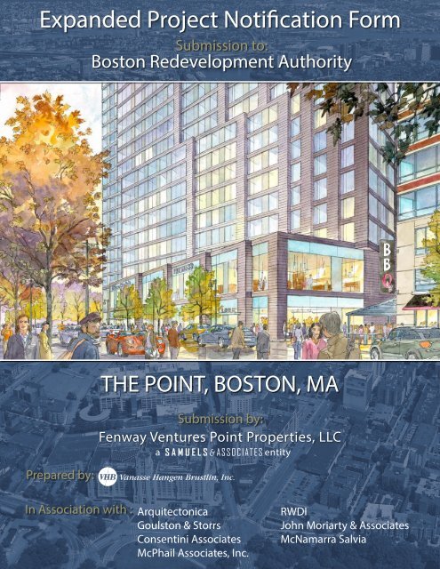
Expanded Project Notication Form<br />
Submission to:<br />
<strong>Boston</strong> <strong>Redevelopment</strong> <strong>Authority</strong><br />
Prepared by:<br />
THE POINT, BOSTON, MA<br />
Submission by:<br />
Fenway Ventures Point Properties, LLC<br />
a entity<br />
In Association with : Arquitectonica<br />
Goulston & Storrs<br />
Consentini Associates<br />
McPhail Associates, Inc.<br />
RWDI<br />
John Moriarty & Associates<br />
McNamarra Salvia
The Point<br />
Expanded Project Notification Form<br />
<strong>Boston</strong>,<br />
Massachusetts<br />
Submitted to<strong>Boston</strong> <strong>Redevelopment</strong> <strong>Authority</strong><br />
Proponent Fenway Ventures Point Properties, LLC,<br />
a Samuels & Associates entity<br />
333 Newbury Street<br />
<strong>Boston</strong> MA 02115<br />
Prepared by Vanasse Hangen Brustlin, Inc.<br />
99 High Street<br />
<strong>Boston</strong>, MA<br />
In association with:<br />
Arquitectonica Architects<br />
Cosentini Associates<br />
Goulston & Storrs<br />
John Moriarty & Associates<br />
McNamara Salvia<br />
McPhail Associates, Inc.<br />
RWDI<br />
February 20<strong>13</strong>
Vanasse Hangen Brustlin, Inc.<br />
The Point, <strong>Boston</strong><br />
Project Description<br />
\\MABOS\projects\1<strong>13</strong>81.00\reports\Article80\<br />
Expanded_PNF\00c_TOC_FINAL.doc i Table of Contents<br />
Table of Contents<br />
Introduction ............................................................................................................................. S-1<br />
Project Context and Exiting Site Conditions ........................................................................... S-2<br />
Project Context ....................................................................................................... S-2<br />
Existing Site Conditions .......................................................................................... S-2<br />
Project Description .................................................................................................................. S-3<br />
Project Phasing and Schedule ................................................................................ S-5<br />
Consistency with Public Planning ........................................................................................... S-5<br />
Fenway/Kenmore Neighborhood Planning Initiatives ............................................. S-5<br />
Commonwealth of Massachusetts .......................................................................... S-8<br />
Community Outreach .............................................................................................................. S-9<br />
Summary of Project Benefits .................................................................................................. S-9<br />
Summary of Project Impacts ................................................................................................. S-12<br />
Urban Design ........................................................................................................ S-12<br />
Transportation ....................................................................................................... S-12<br />
Pedestrian Wind .................................................................................................... S-<strong>13</strong><br />
Shadow ................................................................................................................. S-<strong>13</strong><br />
Daylight ................................................................................................................. S-14<br />
Solar Glare ............................................................................................................ S-14<br />
Air Quality ............................................................................................................. S-14<br />
Water Quality and Flood Hazard ........................................................................... S-14<br />
Geotechnical/Groundwater ................................................................................... S-15<br />
Solid and Hazardous Waste ................................................................................. S-15<br />
Noise ..................................................................................................................... S-15<br />
Construction .......................................................................................................... S-16<br />
Sustainable Building Design ................................................................................. S-16<br />
Infrastructure Systems .......................................................................................... S-16<br />
Historic Resources ................................................................................................ S-17<br />
Expanded PNF Contents ...................................................................................................... S-17<br />
Chapter 1: General Information and Regulatory Context<br />
Introduction ............................................................................................................................. 1-1<br />
Applicant Information .............................................................................................................. 1-1<br />
Development Team ................................................................................................. 1-1<br />
Prior Development Experience ............................................................................... 1-2<br />
Legal Information .................................................................................................... 1-3<br />
Financial Information ............................................................................................... 1-3
Vanasse Hangen Brustlin, Inc.<br />
The Point, <strong>Boston</strong><br />
\\MABOS\projects\1<strong>13</strong>81.00\reports\Article80\<br />
Expanded_PNF\00c_TOC_FINAL.doc ii Table of Contents<br />
Regulatory Controls, Approvals, and Permits ......................................................................... 1-3<br />
Anticipated State and Local Permits and Other Approvals ..................................... 1-4<br />
Zoning Controls ....................................................................................................... 1-5<br />
Planned Development Area (PDA) ......................................................................... 1-6<br />
Article 80 Review – Large Project Review .............................................................. 1-6<br />
Conformity with Public Benefits Criteria .................................................................. 1-7<br />
Impact Advisory Group ........................................................................................... 1-7<br />
Meetings with Other Interested Parties ................................................................... 1-8<br />
Chapter 2: Urban Design<br />
Introduction ............................................................................................................................. 2-1<br />
Summary of Key Findings ....................................................................................... 2-1<br />
Urban Context ......................................................................................................................... 2-2<br />
Design Concept and Development ......................................................................................... 2-2<br />
Height and Massing ................................................................................................ 2-3<br />
Character and Materials .......................................................................................... 2-4<br />
Views and Vistas .................................................................................................................... 2-4<br />
Open Space, Pedestrian Ways, and Amenities ...................................................................... 2-4<br />
Vehicular Access and Circulation ........................................................................................... 2-4<br />
Chapter 3: Transportation<br />
Introduction ............................................................................................................................. 3-1<br />
Summary of Findings .............................................................................................. 3-1<br />
Project Overview ..................................................................................................................... 3-3<br />
Study Methodology ................................................................................................................. 3-3<br />
Traffic Study Area ................................................................................................... 3-4<br />
Analysis Conditions ................................................................................................. 3-4<br />
Existing Transportation Conditions ......................................................................................... 3-4<br />
Roadways ............................................................................................................... 3-4<br />
Study Area Intersections ......................................................................................... 3-5<br />
Data Collection ........................................................................................................ 3-6<br />
Public Transportation .............................................................................................. 3-7<br />
Pedestrian Environment and Accessibility .............................................................. 3-8<br />
Bicycles ................................................................................................................... 3-8<br />
Existing Parking ...................................................................................................... 3-9<br />
Future Conditions ................................................................................................................... 3-9<br />
No-Build Condition .................................................................................................. 3-9<br />
Build Condition ...................................................................................................... 3-11<br />
Traffic Operations Analysis ................................................................................................... 3-14<br />
Conclusion ............................................................................................................................ 3-18<br />
Chapter 4: Environmental Protection<br />
Introduction ............................................................................................................................. 4-1
Vanasse Hangen Brustlin, Inc.<br />
The Point, <strong>Boston</strong><br />
\\MABOS\projects\1<strong>13</strong>81.00\reports\Article80\<br />
Expanded_PNF\00c_TOC_FINAL.doc iii Table of Contents<br />
Analysis Conditions ................................................................................................. 4-2<br />
Pedestrian Wind ..................................................................................................................... 4-2<br />
Shadow ................................................................................................................................... 4-7<br />
Daylight ................................................................................................................................. 4-10<br />
Solar Glare ............................................................................................................................ 4-12<br />
Air Quality ............................................................................................................................. 4-15<br />
Water Quality ........................................................................................................................ 4-26<br />
Flood Hazard ........................................................................................................................ 4-26<br />
Groundwater and Geotechnical ............................................................................................ 4-26<br />
Solid and Hazardous Waste ................................................................................................. 4-27<br />
Noise ..................................................................................................................................... 4-28<br />
Construction .......................................................................................................................... 4-34<br />
Rodent Control Post-Construction ........................................................................................ 4-38<br />
Green Building/Sustainability ................................................................................................ 4-38<br />
Chapter 5: Infrastructure Systems<br />
Introduction ............................................................................................................................. 5-1<br />
Summary of Key Findings ....................................................................................... 5-1<br />
Regulatory Framework ........................................................................................................... 5-2<br />
Drainage/Stormwater Management ........................................................................................ 5-3<br />
Existing Drainage Conditions .................................................................................. 5-3<br />
Proposed Drainage Conditions ............................................................................... 5-3<br />
Compliance with <strong>Boston</strong> Zoning Code Article 32: Groundwater Conservation<br />
Overlay District ....................................................................................................... 5-3<br />
Sanitary Sewage ..................................................................................................................... 5-4<br />
Existing Sewer System ........................................................................................... 5-4<br />
Proposed Sewage Flow and Connection ................................................................ 5-4<br />
Domestic Water and Fire Protection ....................................................................................... 5-5<br />
Existing Water Supply System ................................................................................ 5-5<br />
Proposed Water Supply Demand and Connection ................................................. 5-5<br />
Utilities .................................................................................................................................... 5-5<br />
Natural Gas Service ............................................................................................... 5-5<br />
Electrical Service .................................................................................................... 5-6<br />
Telephone ............................................................................................................... 5-6<br />
Telecommunications ............................................................................................... 5-6<br />
Protection of Utilities ............................................................................................... 5-7<br />
Chapter 6: Historic Resources<br />
Introduction ............................................................................................................................. 6-1<br />
Summary of Key Findings ....................................................................................... 6-1<br />
Existing On-Site Structures ..................................................................................................... 6-2<br />
Existing Historic Resources .................................................................................................... 6-2<br />
Existing Archaeological Resources ........................................................................................ 6-5
Vanasse Hangen Brustlin, Inc.<br />
The Point, <strong>Boston</strong><br />
\\MABOS\projects\1<strong>13</strong>81.00\reports\Article80\<br />
Expanded_PNF\00c_TOC_FINAL.doc iv Table of Contents<br />
Project Impacts to Historic Resources .................................................................................... 6-6<br />
Chapter 7: Project Certification<br />
APPENDICES<br />
Included in this document:<br />
Appendix A Letter of Intent<br />
Provided as electronic files on the enclosed CD-Rom (hard copies are available<br />
upon request):<br />
Appendix B Transportation Supporting Documentation<br />
Appendix C Pedestrian Wind Supporting Documentation<br />
Appendix D Solar Glare Supporting Documentation<br />
Appendix E Air Quality Supporting Documentation<br />
Appendix F Noise Supporting Documentation
Vanasse Hangen Brustlin, Inc.<br />
The Point, <strong>Boston</strong><br />
\\MABOS\projects\1<strong>13</strong>81.00\reports\Article80\<br />
Expanded_PNF\00c_TOC_FINAL.doc v Table of Contents<br />
List of Tables/Charts<br />
Table Description Page<br />
S-1 Proposed Development Program ..................................................................................... S-4<br />
1-1 List of Anticipated Permits and Approvals ........................................................................ 1-4<br />
1-2 Zoning Code Dimensional Regulations and Project Dimensions ..................................... 1-5<br />
3-1 Project Development Program ......................................................................................... 3-3<br />
3-2 MBTA Service ................................................................................................................. 3-7<br />
3-3 Peak Existing Bicycle Storage ......................................................................................... 3-9<br />
3-4 Trip Generation Land Use Codes ................................................................................... 3-11<br />
3-5 Mode Split by Land Use Category .................................................................................. 3-11<br />
3-6 Total Project Trip Generation ......................................................................................... 3-12<br />
3-7 Geographic Distribution .................................................................................................. 3-12<br />
3-8 Level of Service Criteria ................................................................................................. 3-15<br />
3-9 Intersection Level of Service (LOS) Summary ............................................................... 3-17<br />
4-1 <strong>Boston</strong> <strong>Redevelopment</strong> <strong>Authority</strong> Mean Wind Criteria ..................................................... 4-5<br />
4-2 National Ambient Air Quality Standards ......................................................................... 4-15<br />
4-3 Predicted Maximum 1-Hour CO Concentrations ............................................................ 4-21<br />
4-4 Predicted Maximum 8-Hour CO Concentrations ........................................................... 4-22<br />
4-5 Predicted Maximum 24-Hour PM10 Concentrations ...................................................... 4-23<br />
4-6 Predicted Maximum 24-Hour PM2.5 Concentrations ..................................................... 4-24<br />
4-7 Predicted Maximum Annual PM2.5 Concentrations ....................................................... 4-25<br />
4-8 Common Outdoor and Indoor Sound Levels .................................................................. 4-30<br />
4-9 City of <strong>Boston</strong> Zoning District Noise Standards ............................................................. 4-31<br />
4-10 Measured Existing Sound Levels ................................................................................... 4-33<br />
4-11 Sensitive Receptor Location Sound Levels .................................................................... 4-34<br />
5-1 Article 32 Infiltration Volumes .......................................................................................... 5-4
Vanasse Hangen Brustlin, Inc.<br />
The Point, <strong>Boston</strong><br />
*Note: All figures are located at the end of each chapter.<br />
Figure No. Description<br />
S.1 Site Location Map<br />
S.2 Project Area Context<br />
S.3 Existing Conditions Site Plan<br />
S.4 Existing Site Photographs<br />
S.5a Proposed Ground Floor Plan<br />
S.5b Proposed Level 2 Floor Plan<br />
S.5c Proposed Levels 3-4 Typical Residential Floor Plan<br />
S.5d Proposed Levels 5-9 Typical Residential Floor Plan<br />
S.5e Proposed Levels 10-12 Typical Residential Floor Plan<br />
S.5f Proposed Levels <strong>13</strong>-22 Typical Residential Floor Plan<br />
S.5g Proposed Level 23 Floor Plan<br />
S.6 Project Rendering<br />
2.1 Building Development Plan<br />
2.2a West Building Elevation<br />
2.2b East Building Elevation<br />
2.2c South Building Elevation<br />
2.2d North Building Elevation<br />
2.3a North-South Section Looking East<br />
2.3b East-West Section Looking North<br />
2.4 Plan and Massing Diagrams<br />
3.1 Proposed Site Access and Circulation<br />
3.2 Traffic Study Area<br />
3.3 2012 Existing Conditions AM Peak Traffic Volumes<br />
3.4 2012 Existing Conditions PM Peak Traffic Volumes<br />
3.5 2012 Existing Conditions AM Peak Pedestrian Volumes<br />
3.6 2012 Existing Conditions PM Peak Pedestrian Volumes<br />
3.7 Existing Public Transportation<br />
3.8 2012 Existing Conditions AM Peak Bicycle Volumes<br />
3.9 2012 Existing Conditions PM Peak Bicycle Volumes<br />
3.10 Summary of Nearby On-Street Parking Regulations<br />
3.11 2017 No-Build Conditions AM Peak Traffic Volumes<br />
3.12 2017 No-Build Conditions PM Peak Traffic Volumes<br />
\\MABOS\projects\1<strong>13</strong>81.00\reports\Article80\<br />
Expanded_PNF\00c_TOC_FINAL.doc vi Table of Contents<br />
List of Figures
Vanasse Hangen Brustlin, Inc.<br />
The Point, <strong>Boston</strong><br />
3.<strong>13</strong> Vehicle Trip Distribution<br />
3.14 Project Trips AM Peak Hour Traffic Volumes<br />
3.15 Project Trips PM Peak Hour Traffic Volumes<br />
3.16 2017 Build Conditions AM Peak Traffic Volumes<br />
3.17 2017 Build Conditions PM Peak Traffic Volumes<br />
3.18 Publicly Available Existing Off-Street Parking (Non-Game Day)<br />
4.1a No-Build Pedestrian Wind Conditions<br />
4.1b Build Pedestrian Wind Conditions<br />
4.2a Shadow Impacts - March 21<br />
4.2b Shadow Impacts - June 21<br />
4.2c Shadow Impacts - September 21<br />
4.2d Shadow Impacts - December 21<br />
4.3 Dayllight Analysis<br />
4.4 Microscale ("hot spot") Analysis Intersection Locations<br />
4.5 Noise Measurement Locations<br />
4.6 Preliminary LEED Scorecard<br />
5.1 Existing Utilities<br />
6.1 Historic Resources in the Vicinity of the Project Site<br />
6.2 Site Photo Locations<br />
6.3a-g Site Photographs<br />
\\MABOS\projects\1<strong>13</strong>81.00\reports\Article80\<br />
Expanded_PNF\00c_TOC_FINAL.doc vii Table of Contents
Introduction<br />
Vanasse Hangen Brustlin, Inc.<br />
The Point, <strong>Boston</strong><br />
\\MABOS\projects\1<strong>13</strong>81.00\reports\Article80\Ex<br />
panded_PNF\00d_ProjDescription_FINAL.doc S-1 Project Description<br />
Project Description<br />
This expanded Project Notification Form (PNF) is submitted pursuant to the Article 80 - Large Project Review<br />
process under the <strong>Boston</strong> Zoning Code and Enabling Act. This expanded PNF presents details about The<br />
Point project proposed at the juncture of Boylston Street and Brookline Avenue in <strong>Boston</strong>’s Fenway<br />
neighborhood (the “Project”). This PNF provides an analysis of traffic/transportation, potential<br />
environmental impacts, infrastructure needs, as well as urban design and other aspects of the Project, in order<br />
to inform state and city agencies, and neighborhood residents about the Project, its potential impacts, and the<br />
mitigation measures proposed to address those potential impacts.<br />
Samuels & Associates, through its subsidiary, Fenway Ventures Point Properties LLC (the “Proponent”), proposes<br />
the redevelopment of an approximately 0.6-acre triangular site at the juncture of Boylston Street and Brookline<br />
Avenue in <strong>Boston</strong>’s Fenway neighborhood (the “Project Site”). <strong>Redevelopment</strong> of the Project Site consists of<br />
construction of a new residential building, with retail on the first and second floors, and residential amenities,<br />
mechanical space, and other accessory uses and facilities.<br />
The Project will expand on the recent mixed use developments in the Fenway and the transformation from<br />
industrial uses to neighborhood uses along Boylston Street with a compelling and iconic building design featured<br />
at the gateway to the Fenway area. Overall, the Project will enhance the architectural character, urban design, retail<br />
vitality, and pedestrian experience with new street level activity at this key entrance to the community. The Project<br />
will also generate numerous positive neighborhood benefits, including increased housing, additional shopping<br />
opportunities, upgrading of the urban fabric, and significantly improved pedestrian walkways and streetscape.<br />
The City and the region as a whole will benefit from job creation, housing, and additional city and state tax<br />
revenues associated with the Project.<br />
Sustainability is integrated throughout the Project as it aims to use land efficiently through the revitalization of an<br />
underutilized site in a dense urban setting, promote the use of alternative modes of transportation, encourage<br />
pedestrian activity and improve water quality. Due to the location of the Project Site in a dense established urban<br />
neighborhood with access to public transportation and available services in close proximity, many of the residents<br />
and their guests, as well as retail employees and customers, will use alternative means of transportation to/from<br />
the Project. Additionally, in accordance with Article 37 – Green Buildings of the <strong>Boston</strong> Zoning Code, the<br />
Proponent intends to incorporate state-of-the-art sustainable features into the design of the Project, where feasible<br />
and reasonable, so that the building could achieve the minimum certification level (“Certified”) under the U.S.<br />
Green Building Council (USGBC) Leadership in Environmental and Energy Design (LEED®) Green Building<br />
Rating System, or “LEED certifiable.” 1<br />
<br />
1 LEED “certifiable” indicates that a building meets the energy reduction requirements under the most appropriate<br />
LEED building rating system, but has not officially registered with the USGBC to become certified.
Vanasse Hangen Brustlin, Inc.<br />
The Point, <strong>Boston</strong><br />
The following chapter provides an overview of existing site conditions and describes the Project. This chapter<br />
also discusses how the Project is consistent with applicable local planning initiatives and municipal and state<br />
land use plans and policies, and provides a description of the ongoing public participation and outreach. A<br />
summary of public benefits and positive impacts anticipated as a result of the Project is also presented. Lastly,<br />
a summary of findings from the impact analyses presented in subsequent chapters of this expanded PNF is<br />
provided.<br />
Project Context and Exiting Site Conditions<br />
<br />
Project Context<br />
The Project Site is a triangular block totaling 0.6 acres located at the corner of Brookline Avenue and Boylston<br />
Street in the Fenway neighborhood of <strong>Boston</strong>, Massachusetts. Refer to Figure S.1 for a site location map.<br />
Boylston Street borders the Project Site to the south and connects the Sears Rotary to the west with<br />
Downtown <strong>Boston</strong> to the east. Brookline Avenue borders the Project Site to the north connecting Brookline<br />
Village to the west with Kenmore Square to the east. The Project Site has an important relationship with the<br />
Emerald Necklace and Park Drive, located to the east, west and south of the Project Site. This long, linear<br />
district is comprised of the Back Bay Fens, the Muddy River, Olmsted (Leveret) Park, Jamaica Pond and the<br />
Arborway. The Fenway Park baseball stadium is located approximately 1/3-mile east of the Project Site down<br />
Brookline Avenue. Refer to Figure S.2 for an aerial image of the site and neighborhood context.<br />
In general, the land uses surrounding the Project Site consist of a varying mix of building typologies, sizes<br />
and heights. Some buildings, specifically along Brookline Avenue, are remnants of the automotive industry of<br />
the 1920’s while others include brick residential structures built after 1930, late-20th century low-rise<br />
commercial buildings, free-standing single-story restaurants, and surface parking lots. More recently, the<br />
project area has been greatly influenced by its proximity to Fenway Park, the Landmark Center retail district,<br />
various institutions, such as Emmanuel College and the Longwood Medical and Academic Area (LMA) as well as<br />
the residential neighborhood south of Boylston Street. These surrounding land uses have resulted in several<br />
successful large mixed use developments by Samuels & Associates (most notably Trilogy, <strong>13</strong>30 Boylston Street,<br />
and the future Fenway Triangle Mixed Use project) significantly expanding market rate and affordable housing,<br />
office, and retail opportunities. These developments have set the context for the continued transformation of the<br />
remaining underutilized parcels with ‘service’ uses (e.g., fast food establishments, low-end retail, gas<br />
stations/automotive servicing) along Boylston Street and Brookline Avenue.<br />
<br />
Existing Site Conditions<br />
Figure S.3 shows the existing conditions site plan. The existing conditions at the Project Site are vestiges of the<br />
automotive industry of the 1920’s, traces of which continue to be visible along Brookline Avenue. The<br />
approximately 25,191-square foot (0.60-acre) triangular parcel is completely built-out with three connected<br />
one-story brick buildings totaling approximately 20,150 square feet (176-184 Brookline Avenue, 200 Brookline<br />
\\MABOS\projects\1<strong>13</strong>81.00\reports\Article80\Ex<br />
panded_PNF\00d_ProjDescription_FINAL.doc S-2 Project Description
Vanasse Hangen Brustlin, Inc.<br />
The Point, <strong>Boston</strong><br />
Avenue, and <strong>13</strong>87 Boylston Street) and some surface parking and loading/service areas. These buildings were<br />
all constructed in the early 1900s. The current and or most recent commercial tenants of the existing buildings<br />
include a D’Angelo sandwich shop, ACE tickets, TOMB interactive adventure, a liquor store, office space,<br />
band rehearsal space and storage space in the basement. Refer to Figure S.4 for photographs of the existing site.<br />
There are approximately 27 parking spaces currently on-site (15 surface spaces and 12 below-grade spaces).<br />
Surface spaces along Boylston Street adjacent to the existing building structure (where no formal sidewalk<br />
exists) are used primarily by patrons of the existing establishments. The below-grade parking spaces are<br />
accessible by a ramp off of Boylston Street.<br />
The Project Site is currently well served by infrastructure, some of which was recently upgraded, and is in<br />
close proximity to public transit (MBTA Green Line, the Framingham/Worcester Commuter Rail Line, and<br />
multiple bus routes).<br />
Project Description<br />
The Proponent proposes the construction of a new 22-story mixed-use building totaling approximately<br />
302,292 Floor Area Ratio (FAR) square feet consisting of retail and residential lobby and service space on the first<br />
two levels, residential and amenity space on the upper floors, including a residential outdoor amenity deck at the<br />
roof level. Refer to Figures S.5a and S.5b for the proposed ground floor and Level 2 building plans,<br />
respectively. Figures S.5c-f show the proposed typical layouts for the residential levels and Figure S.5g shows<br />
the rooftop layout.<br />
The overall goal of the project architecture is to provide a compelling and iconic structure at the gateway to<br />
the Fenway neighborhood, while remaining compatible with the surrounding mix of uses. The vibrant<br />
mixed-use building will contribute to the long term revitalization of the Fenway district by building on the<br />
momentum generated by the neighboring, larger-scale, recent mixed-use developments and by creating new<br />
residential and retail activities and public realm improvements.<br />
The retail component consists of approximately 33,000 FAR square feet suitable for retail and/or restaurant<br />
uses (with additional space available for outdoor dining). The residential component is anticipated to include<br />
approximately 320 units totaling approximately 269,000 FAR square feet, with a mix including studio, one-,<br />
two-, three- and/or four-bedroom layouts served from a dedicated ground-floor lobby. Both residents and<br />
retail customers will utilize existing parking capacity at the adjacent Trilogy Garage accessible from existing<br />
driveways on Brookline Avenue and Kilmarnock Street. A new elevated glass walkway over the driveway<br />
between the Project and Trilogy will connect residential uses of both of these buildings at the second level<br />
with a potential subsurface pedestrian connection as well. The transparent pedestrian connection will<br />
contribute to a more lively and active street life. Table S-1 summarizes the proposed development program.<br />
\\MABOS\projects\1<strong>13</strong>81.00\reports\Article80\Ex<br />
panded_PNF\00d_ProjDescription_FINAL.doc S-3 Project Description
Vanasse Hangen Brustlin, Inc.<br />
The Point, <strong>Boston</strong><br />
Table S-1<br />
Proposed Development Program<br />
Land Use Floor Level<br />
Size/Quantity<br />
(approximate)<br />
Retail Floors 1 and 2 33,292 FAR SF<br />
Residential Floors 3-22 269,000 FAR SF<br />
320 units<br />
Total Development Program<br />
FAR Floor Area Ratio<br />
GSF Gross Square Feet<br />
302,292 FAR GSF<br />
320 units<br />
The proposed residential tower above the retail is set back on the north and on the south. The residential building<br />
massing is broken into three slender bars with the middle bar stepping out towards the junction of Boylston Street<br />
and Brookline Avenue. The lower levels of the retail base are positioned towards the streetscape reinforcing an<br />
activated pedestrian realm and enhancing pedestrian interaction and attraction along storefronts. Refer to<br />
Figure S.6 for a rendering of the Project. Chapter 2, Urban Design of this PNF provides additional detail on the<br />
building design concept, including the floor plans and renderings.<br />
A number of public realm and site access improvements are proposed as part of the Project. The existing<br />
surface parking, which currently impedes a continuous sidewalk on Boylston Street, will be eliminated. All<br />
sidewalks adjacent to the Project Site will be reconstructed in coordination with the city’s Boylston Street<br />
Improvement Project. Improvements are expected to include street trees, new curbing and sidewalks, and<br />
ornamental street lighting to enhance the pedestrian environment and insure public safety. A pedestrian path<br />
connecting Brookline Avenue and Boylston Street, which will be open to the public, will be maintained<br />
through the Site. In accordance with BTD guidelines, bicycle racks will be installed within the building for<br />
residents and tenants. Additional short-term bicycle storage will also be provided at street level. To reduce<br />
potential congestion on local roadways caused by servicing the building, an off-street/on-site loading dock<br />
internal to the building will be provided as part of the Project and will be accessed via the service driveway<br />
shared with Trilogy between Brookline Avenue and Boylston Street. The Project also proposes a designated<br />
on-street loading zone adjacent to the Project Site on Brookline Ave for vehicles that cannot be accommodated<br />
on-site.<br />
The Project lies at the intersection of Boylston Street and Brookline Avenue which are major local utility<br />
corridors and, as a result, the Project Site is very well served by utility infrastructure. Connections to major<br />
utility are available along the site frontage. The Proponent has worked with the <strong>Boston</strong> Water and Sewer<br />
Commission (BWSC) and private utility agencies on previous projects in the neighborhood coordinating<br />
services and network improvements. Furthermore, the customers, employees, and residents will be able to<br />
take advantage of the various public transit connections easily accessible from the Project Site, including the<br />
MBTA Green Line and numerous bus routes.<br />
Project-related benefits, which are summarized in detail below, include job creation, urban design<br />
improvements, neighborhood revitalization, housing opportunities, expanded retail options, and additional<br />
tax revenues. By replacing an underutilized building, the Project will substantially improve the pedestrian<br />
environment, the retail vitality of the neighborhood, as well as the urban design and architectural character of<br />
the area. Also, the Project will further the goals of the Fenway area planning initiatives put in place in 2004.<br />
\\MABOS\projects\1<strong>13</strong>81.00\reports\Article80\Ex<br />
panded_PNF\00d_ProjDescription_FINAL.doc S-4 Project Description
Project Phasing and Schedule<br />
Vanasse Hangen Brustlin, Inc.<br />
The Point, <strong>Boston</strong><br />
The duration of construction for the Project is expected to last approximately 24 months. Demolition is<br />
anticipated to begin within approximately six months following Article 80 approval.<br />
Consistency with Public Planning<br />
This section describes how the Project is consistent with applicable local planning initiatives and municipal<br />
and state land use plans and policies.<br />
<br />
Fenway/Kenmore Neighborhood Planning Initiatives<br />
As part of a 2006 legislatively enacted economic stimulus package, $36 million was set aside by the State for<br />
the construction, development, modernization, rehabilitation, upgrade and improvement of transportation<br />
related infrastructure in the City of <strong>Boston</strong> focused on the Fenway Neighborhood and the Longwood Medical<br />
and Academic Area. These improvements were targeted to support job growth and economic advancement.<br />
Cited among the engines of this advancement was the investment in commercial and residential facilities. The<br />
Project responds to the goals of the legislation in that its related transportation improvements dovetail with<br />
on-going City planning for improvements to Boylston Street and Brookline Avenue, including the traffic<br />
improvements being performed by the Army Corps of Engineers as part of the Muddy River Restoration<br />
Project.<br />
The transportation-related improvements being advanced by the City as part of the Fenway - Longwood -<br />
Kenmore Transportation & Pedestrian Safety Action Plan (the “Action Plan”) include reconstructing Boylston<br />
Street to significantly improve the pedestrian and bicycle commuter environment through the provision of<br />
wider sidewalks with street trees, curb extensions at intersections, and the addition of bicycle lanes, while<br />
maintaining traffic capacity. 2 The Project, as currently envisioned, will incorporate the planned sidewalk<br />
improvements along its Boylston Street and Brookline Avenue frontage as well as include an enhanced<br />
pedestrian cross-connection between these two streets.<br />
As part of the Massachusetts Works program, the Commonwealth and the MBTA recently broke ground on<br />
the $<strong>13</strong>.5 million Yawkey Commuter Rail Station reconstruction project, which will be integrated into the<br />
future Fenway Center development. The new rail station will improve connectivity between Beacon Street,<br />
Brookline Avenue, and the future Mixed-Use Path (proposed as part of the Action Plan). The Project proposes<br />
to activate Brookline Avenue and Boylston Street through the introduction of ground-floor retail uses. This<br />
retail space will provide the services that generate pedestrian activity and will expand the economic footprint<br />
of the neighborhood by extending the existing pedestrian activity from Fenway Park further west down<br />
Brookline Avenue, and by aiding the transformation of Boylston Street from an underutilized corridor to a<br />
<br />
2 <strong>Boston</strong> Transportation Department, Fenway - Longwood - Kenmore Transportation & Pedestrian Safety Action Plan,<br />
Spring 2009.<br />
\\MABOS\projects\1<strong>13</strong>81.00\reports\Article80\Ex<br />
panded_PNF\00d_ProjDescription_FINAL.doc S-5 Project Description
Vanasse Hangen Brustlin, Inc.<br />
The Point, <strong>Boston</strong><br />
destination street. In this way, the Project supports all of the area infrastructure enhancements being<br />
implemented by various entities.<br />
Open Space Plan 2008-2014<br />
The <strong>Boston</strong> Parks & Recreation Department Design & Construction Unit prepared the Open Space Plan 2008-<br />
2014, which assesses existing parks and recreational facilities and identifies goals and objectives for<br />
maintaining and improving these facilities, including a five-year implementation plan. 3<br />
The existing Project Site is in close proximity to the Back Bay Fens—a public park that is part of the larger,<br />
more extensive Emerald Necklace park system. The Back Bay Fens includes a Community Garden and offers<br />
both passive and active recreational options, including the World War II, Vietnam and Korean War<br />
Memorials, the Kelleher Rose Garden, and the Mother's Rest playground, as well as basketball courts,<br />
baseball fields, a running tack, and walking/biking paths. Additionally, on-leash dogs are allowed in the<br />
park. The Project Site is approximately a ½-mile from DCR's Charles River Reservation—a linear park<br />
stretching from the <strong>Boston</strong> Harbor up the river for 20 miles and accessible by most city neighborhoods. Due<br />
to the extensive amount of public open space in close proximity to Project, the introduction of new residents<br />
to the area is not expected to have a significant impact on any city-owned recreational facilities.<br />
Climate Action Plan<br />
On Earth Day, April 22, 2011, Mayor Thomas M. Menino released A Climate of Progress – the City’s updated<br />
Climate Action Plan. 4 This Plan encompasses the April, 2010 consensus report Sparking <strong>Boston</strong>’s Climate<br />
Revolution: Recommendations of <strong>Boston</strong>’s Climate Action Leadership Committee and Community Advisory Committee 5<br />
and is to be used in tandem with Sparking the Climate Revolution by including a set of wide-ranging<br />
recommendations aimed at significantly reducing greenhouse gas (GHG) emissions and preparing for the<br />
risks of climate change in <strong>Boston</strong>. The five overarching recommendations of the Climate Action Leadership<br />
Committee are:<br />
1. Reduce <strong>Boston</strong>’s GHG emissions 25 percent by 2020;<br />
2. Immediately start incorporating projected effects of climate change — particularly sea level rise, heat<br />
waves, and more intense storms — in all planning and review for municipal and private projects;<br />
3. Develop a comprehensive public engagement effort, including a public commission and strong<br />
partnerships with community organizations;<br />
4. Use climate action opportunities to advance <strong>Boston</strong>’s green economy and jobs goals; and<br />
<br />
3 City of <strong>Boston</strong> Parks & Recreation Department Design & Construction Unit, Open Space Plan 2008-2014, January<br />
2008. Website: http://www.cityofboston.gov/parks/openspace0814.asp<br />
4 City of <strong>Boston</strong>, A Climate of Progress: City of <strong>Boston</strong> Climate Action Plan Update, April 2011. Website:<br />
http://www.cityofboston.gov/Images_Documents/A%20Climate%20of%20Progress%20-<br />
%20CAP%20Update%202011_tcm3-25020.pdf<br />
5 City of <strong>Boston</strong>, Sparking <strong>Boston</strong>'s Climate Revolution Recommendations of the Climate Action Leadership Committee<br />
and Community Advisory Committee, April 2010. Website:<br />
http://www.cityofboston.gov/Images_Documents/BCA_full_rprt_r5_tcm3-19558.pdf<br />
\\MABOS\projects\1<strong>13</strong>81.00\reports\Article80\Ex<br />
panded_PNF\00d_ProjDescription_FINAL.doc S-6 Project Description
Vanasse Hangen Brustlin, Inc.<br />
The Point, <strong>Boston</strong><br />
5. Ensure that climate action has clear public and private leadership and sufficient public and private<br />
resources.<br />
Achieving these goals of reducing the effects of climate change, cultivating a city of green buildings, and<br />
advancing sustainability in multiple realms is intended to drive economic development and innovation.<br />
In 2010, the City of <strong>Boston</strong> was designated a Green Community under the Green Communities Designation<br />
and Grant Program, an initiative of the Department of Energy Resources (DOER). In order to be designated a<br />
Green Community and, therefore, be eligible for grant money available annually, communities are required<br />
to meet five qualification criteria, such as adopt and implement the Stretch Energy Code. 6 The goal of the<br />
grant program is for a municipality to use grant money to assist residents, businesses, and municipal<br />
departments/facilities to reduce energy use or install renewable energy systems.<br />
The Project will not provide any new parking and, therefore, aims to encourage the use of alternative<br />
transportation. The Project location is consistent with the goal of reducing GHG emissions associated with<br />
transportation (i.e., fossil fuels) due to its close proximity to public transportation. As discussed in Chapter 3,<br />
Transportation, the vast majority of residents and their guests, as well as retail employees and customers are<br />
expected to primarily use alternative means of transportation to access the Project. In addition to public<br />
transit, the proposed pedestrian improvements, resident secure bicycle storage, and public bike racks will<br />
encourage the use of other alternative modes of transportation to/from the Project, thereby, reducing GHG<br />
emissions associated with gasoline use compared to a conventional development, where access is dependent<br />
on single-occupancy vehicles.<br />
The Project building will be designed to meet the Stretch Energy Code (a 20 percent energy savings compared<br />
to a building constructed to meet the Massachusetts Energy Code minimum requirements). Energy efficient<br />
heating and cooling building systems as well as windows with double glazing and an improved U-value are<br />
key energy conservation measures that have been incorporated into conceptual design. Preliminary building<br />
energy model runs assuming these measures are showing an energy savings of approximately 23 percent.<br />
(This building energy performance goal will continue to be assessed as building systems are evaluated and<br />
selected throughout the design process.) Additionally, the Proponent will develop construction and design<br />
guidelines to encourage retail tenants to include energy conservation measures and sustainable features in<br />
their fit-outs. The Proponent will also provide residents with operations guidelines, which may include<br />
information on the sustainable aspects of the Project, such as information on installed Energy Star appliances,<br />
the City of <strong>Boston</strong> recycling program, and a copy of the Project’s ‘No Smoking’ policy. These guidelines will<br />
aim to encourage residential tenants to reduce their energy consumption by providing them with energy use<br />
tips/measures and suggestions on how to coordinate carpooling to/from work with other tenants. The<br />
energy efficiency performance goals of the Project are expected to result in a reduction in GHG emissions,<br />
which supports the City’s Climate Action Plan goal to reduce overall GHG emission by 25 percent by 2020.<br />
Refer to Chapter 4, Environmental Protection for further details on Project benefits related to sustainable design<br />
and energy conservation.<br />
<br />
6 Effective January 1, 2011, the City of <strong>Boston</strong> adopted the Stretch Energy Code (8th Edition Building Code, Appendix<br />
115.AA); there is a concurrency period through June 30, 2011. Its adoption brings to <strong>Boston</strong> a standard that will<br />
require new commercial buildings over 5,000 square feet in size, including multi-family residential buildings over three<br />
stories, to operate at an energy efficiency level 20% better than that required under the base energy code criterion,<br />
ASHRAE 90.1-2007.<br />
\\MABOS\projects\1<strong>13</strong>81.00\reports\Article80\Ex<br />
panded_PNF\00d_ProjDescription_FINAL.doc S-7 Project Description
Commonwealth of Massachusetts<br />
Vanasse Hangen Brustlin, Inc.<br />
The Point, <strong>Boston</strong><br />
Executive Order 385 – Planning for Growth<br />
Generally, Executive Order 385 (EO 385) aims “…to actively promote sustainable economic development<br />
practices by advocating for state activities that are supported by adequate infrastructure and that are<br />
designed in such a way so that they do not adversely impact the natural environment.” The Project is<br />
consistent with EO 385 because it aims to redevelop a previously developed urban site that has existing and<br />
adequate infrastructure, including public transit. Therefore, the Project reduces or avoids altogether<br />
environmental impacts, such as traffic, new impervious surface, and new land alteration. The Project will<br />
improve water quality through proposed modifications/upgrades to the stormwater management system.<br />
The Project aims to create a mix of economic and social activities, all of which will support the local and state<br />
economy. The Project provides new employment opportunities, including the creation of 350 to 400<br />
construction jobs in all trades and approximately 200 new transit-accessible employment opportunities<br />
(permanent part-time and full-time jobs). In addition, the Project creates approximately 320 new diverse<br />
housing units, a portion of which will be designated as affordable. Furthermore, as outlined in this report, the<br />
Proponent will minimize any unavoidable environmental impacts through the implementation of appropriate<br />
mitigation measures, to the extent feasible.<br />
Commonwealth’s Sustainable Development Principles<br />
The Project is consistent with several of the Office of Commonwealth Development’s Sustainable<br />
Development Principles. 7 The following lists the smart growth principles with which the Project is consistent.<br />
Concentrate Development and Mix Uses. The Project perfectly fulfills this principle as it consists of the<br />
redevelopment of an underutilized urban site with existing/adequate infrastructure and it promotes a<br />
vibrant mixed-use development.<br />
Advance Equity. The Project was developed in coordination with the BRA and the neighborhood so that<br />
its uses aim to support and remain consistent with the community vision for the area.<br />
Make Efficient Decisions. A key goal of the Project is to utilize the existing site to the extent practicable<br />
in order to limit site work. The Project also introduces new pedestrian-friendly and transit-accessible<br />
employment and housing opportunities, thereby reducing local traffic.<br />
Protect Land and Ecosystems. The Project addresses the principle of protecting land and ecosystems by<br />
redeveloping a previously developed urban area instead of developing a ‘greenfield’ site outside the City.<br />
<br />
7 Commonwealth of Massachusetts Sustainable Development Principles (website link:<br />
http://www.mass.gov/Agov3/docs/smart_growth/patrick-principles.pdf)<br />
\\MABOS\projects\1<strong>13</strong>81.00\reports\Article80\Ex<br />
panded_PNF\00d_ProjDescription_FINAL.doc S-8 Project Description
Vanasse Hangen Brustlin, Inc.<br />
The Point, <strong>Boston</strong><br />
Use Natural Resources Wisely. The Project promotes sustainable planning principles through its use of<br />
innovative design elements, such as energy and water efficient building systems and operations, reduced<br />
construction and operational waste, and environmentally-preferable materials.<br />
Expand Housing Opportunities. The Project will expand housing opportunities within the City of<br />
<strong>Boston</strong>, including affordable housing units.<br />
Provide Transportation Choice. The Project promotes transit-oriented development, as the site is<br />
accessible by commuter train, rapid transit, and local buses. In addition, transportation choices will be<br />
expanded for residents and visitors through improved pedestrian access and circulation and bicycle<br />
storage facilities for both customers and residents.<br />
Increase Job and Business Opportunities. The Project provides new employment opportunities<br />
(350 - 400 construction jobs in all trades and approximately 200 new transit-accessible permanent parttime<br />
and full-time jobs).<br />
Promote Clean Energy. The Project will be at minimum 20 percent energy efficient in order to meet both<br />
the Stretch Energy Code and the City of <strong>Boston</strong> Zoning Ordinance Article 37 – Green Buildings LEED<br />
certifiable requirement. Energy efficient building design and systems when compared to conventional<br />
building design will result in reduced GHG emissions.<br />
Community Outreach<br />
The Proponent has a long history of working with the Fenway Neighborhood through development of the<br />
Trilogy, <strong>13</strong>30 Boylston Street, and Fenway Triangle Mixed Use projects as well as through participation in the<br />
planning process leading to the new Article 66 of the <strong>Boston</strong> Zoning Code for the Fenway Neighborhood<br />
District. Chapter 1, General Information and Regulatory Context highlights some of the collaborative efforts to<br />
date involving community groups and other interested parties relating specifically to the proposed project.<br />
The proponent will continue to work with the neighborhood, including the Fenway Civic Association, the<br />
Fenway Community Development Corporation, the Audubon Circle Neighborhood Association, the Red Sox<br />
organization, and other neighborhood representatives through the review and evaluation of this proposal.<br />
Refer to Chapter 1, General Information and Regulatory Context for further details on community outreach for<br />
the Project.<br />
Summary of Project Benefits<br />
Project-related benefits generally include the revitalization of an underutilized urban site and efficient use of<br />
land, promotion of alternative modes of transportation, improved water quality, housing creation and job<br />
opportunities, expanded retail options and additional tax revenues. By replacing an underutilized<br />
commercial building in a dense urban setting, the Project will substantially contribute to improving the<br />
pedestrian and retail vitality, as well as the urban design and architectural character of the Fenway<br />
neighborhood. Specific public benefits include:<br />
\\MABOS\projects\1<strong>13</strong>81.00\reports\Article80\Ex<br />
panded_PNF\00d_ProjDescription_FINAL.doc S-9 Project Description
Vanasse Hangen Brustlin, Inc.<br />
The Point, <strong>Boston</strong><br />
Site Improvements and Neighborhood Design Benefits<br />
Redevelop an underutilized urban site into a vibrant transit- and pedestrian-oriented mixed-use<br />
development.<br />
Significantly improve the aesthetic character of the Project Site, which currently consists of a collection of<br />
low-story commercial uses.<br />
Introduce high-quality and iconic architecture to provide a transformative effect for the neighborhood.<br />
Provide for a project design that was carefully developed to meet the unique needs of a gateway area of<br />
the Fenway Neighborhood and complement the urban design characteristics of the surrounding area.<br />
Improve the urban design characteristics and aesthetic character of the Project Site and its surroundings<br />
through the enhancement of the public realm.<br />
Encourage pedestrian activity through new retail and residential uses creating liveliness along Brookline<br />
Avenue and Boylston Street as an extension of the Fenway neighborhood.<br />
Promote the use of alternative modes of transportation, encourage pedestrian activity, and improve water<br />
quality.<br />
Provide for appropriate building scale and size at the pedestrian realm.<br />
Enhance the streetscape with the use of signage, street furniture, lighting, and landscaping.<br />
Provide an outdoor seating area for potential restaurant occupancy at the south-east corner of the Project<br />
Site along Boylston Street to enhance street life and character and add diversity to the urban texture.<br />
Transportation Improvements<br />
Provide no new parking by connecting to the existing three-level underground parking garage at Trilogy<br />
(the “Trilogy Garage”) allowing for the Project to utilize existing garage driveways on Brookline Avenue<br />
and Kilmarnock Street.<br />
Enhance pedestrian safety and circulation through improved/upgraded sidewalks and street crossings,<br />
and improved illumination of pedestrian walkways.<br />
Balance the vehicular traffic with the pedestrian and bicyclist demands in the neighborhood by<br />
incorporating the City’s Boylston Street reconstruction plans on the Site, including improved sidewalk<br />
spaces and on-site bicycle storage.<br />
Provide new transit-accessible retail and residential uses (reduced single-occupancy vehicle trips to the<br />
Site).<br />
Accommodate service and loading operations off-street/on-site and internal to the building with a new<br />
one-way right turn only egress driveway from the shared Trilogy driveway to allow trucks to exit to<br />
Boylston Street.<br />
Provide new bicycle facilities (in coordination with BTD), including on-site bike storage for retail<br />
customers and employees as well as <strong>cover</strong>ed/secure bike storage for residents.<br />
Implement a substantial Transportation Demand Management (TDM) Plan to encourage the use of<br />
alternate transportation and discourage single-occupancy vehicle trips.<br />
\\MABOS\projects\1<strong>13</strong>81.00\reports\Article80\Ex<br />
panded_PNF\00d_ProjDescription_FINAL.doc S-10 Project Description
Vanasse Hangen Brustlin, Inc.<br />
The Point, <strong>Boston</strong><br />
Reconstruct the sidewalk at the intersection of Brookline Avenue and Boylston Street to eliminate the<br />
channelized right-turn lane and reduce pedestrian crossing <strong>point</strong>s.<br />
Environmental Improvements<br />
Incorporate state-of-the-art sustainable features (i.e., energy- and water-efficient building systems) into<br />
the design of each component of the Project (retail and residential), where feasible and reasonable, in<br />
accordance the City’s Green Building policies and procedures.<br />
Off-set impervious area through Low Impact Design (LID) elements (stormwater infiltration systems) to<br />
promote the infiltration of stormwater runoff into the ground, in accordance with the Groundwater<br />
Conservation Overlay District (GCOD) and DEP Stormwater Management Policy; thereby improving<br />
water quality and reducing the rate and quantity of stormwater discharged to the drainage system and<br />
the Charles River.<br />
Reduce stormwater runoff and "urban heat island" effect of the building through the installation of a<br />
green roof system on the 2-story retail roof areas.<br />
Consider building design (i.e., façade materials, height, and massing) to mitigate the potential for<br />
collision of passing birds.<br />
Use “night-sky friendly” site lighting fixtures.<br />
Infrastructure Improvements<br />
Utilize the existing adequate infrastructure capacity requiring no major infrastructure upgrades.<br />
Upgrade on-site drainage system resulting in reduced rates and quantities of stormwater discharged to<br />
the BWSC stormwater drainage system and, ultimately, the Charles River Basin.<br />
Economic and Community Benefits<br />
Enhance the economy within the Fenway by providing new job opportunities and a source of customers<br />
for local retail and service establishments.<br />
Create 350 to 400 construction jobs in all trades.<br />
Create approximately 200 new transit-accessible employment opportunities (permanent part-time and<br />
full-time jobs).<br />
Increase annual property tax revenue for the City of <strong>Boston</strong>.<br />
Provide approximately 320 new housing units in close proximity to downtown <strong>Boston</strong>, a portion of<br />
which will be set aside as affordable rental housing.<br />
Further, the Proponent will submit a <strong>Boston</strong> Residents Construction Plan, in accordance with the <strong>Boston</strong> Jobs<br />
Policy. To effectuate the Proponent’s affordable housing commitment, the Proponent will finalize an<br />
affordable housing agreement with the BRA during the Article 80 review period for an affordable housing<br />
contribution.<br />
\\MABOS\projects\1<strong>13</strong>81.00\reports\Article80\Ex<br />
panded_PNF\00d_ProjDescription_FINAL.doc S-11 Project Description
Summary of Project Impacts<br />
Vanasse Hangen Brustlin, Inc.<br />
The Point, <strong>Boston</strong><br />
The Project has been thoughtfully designed to integrate into the surrounding neighborhood and to achieve<br />
the goals of the Fenway Neighborhood District. As presented in detail in subsequent chapters, this expanded<br />
PNF compares the future no-build and build conditions in order to identify the potential for the Project to<br />
impact the environment and/or community. This section summarizes the potential impacts of urban design,<br />
transportation, wind, shadow, daylight, solar glare, air quality, noise, solid and hazardous waste,<br />
geotechnical/groundwater, water quality, construction, sustainable design, historic resources and<br />
infrastructure in connection with the Project and proposed mitigation.<br />
<br />
Urban Design<br />
Historically, the project area has included industrial and automotive uses, which have transitioned into<br />
‘service’ uses, such as fast food establishments and convenience retail. Boylston Street is an important<br />
vehicular connector serving the neighborhood and linking downtown to the Longwood Medical and<br />
Academic Area and the City of Brookline to the west. The urban design strategies of the Project have largely<br />
grown out of and evolved from input from the local Fenway community groups as well as the BRA. As<br />
discussed in Chapter 2, Urban Design, the Project proposes to expand upon the recent developments in the<br />
Fenway area and the positive growth along Boylston Street. The design goal of the Project is to help realize<br />
the revitalization of Boylston Street through a strengthened gateway into the Fenway neighborhood with a<br />
new iconic landmark that invigorates the pedestrian realm with both residential and commercial activity.<br />
Public realm improvements, such as an enhanced pedestrian path connecting Brookline Avenue and Boylston<br />
Street, and the proposed open space at the southeast corner of the Project Site along Boylston Street (for<br />
outdoor seating area for a restaurant) will add character and diversity to the urban texture. The proposed<br />
transparent pedestrian connection between the Project and Trilogy over the shared driveway (also a<br />
connecting street) will also contribute to a more lively and active streetscape. Additionally, new streetscapes<br />
will be enhanced by new signage, street furniture, and lighting and landscaping.<br />
<br />
Transportation<br />
The Project is designed to maximize pedestrian access and to minimize traffic and parking impacts. With the<br />
many planned transportation infrastructure projects aimed at improving transit, pedestrian, bicycle, and<br />
traffic operations in the Fenway neighborhood, the additional traffic generated by the Project is expected to<br />
have a limited impact on the area’s roadways. The results of the transportation analyses presented in<br />
Chapter 3, Transportation indicate that there will be no substantial changes in overall level of service (LOS) in<br />
the traffic study area as a result of the Project.<br />
The Project includes no new parking and will utilize parking spaces at the existing Trilogy Garage and the<br />
existing driveways on Brookline Avenue and Kilmarnock Street. The Trilogy garage was constructed with<br />
excess capacity intended for the Project. Any additional parking demands will be met in other area garages<br />
owned by the Proponent or its affiliates in the neighborhood.<br />
\\MABOS\projects\1<strong>13</strong>81.00\reports\Article80\Ex<br />
panded_PNF\00d_ProjDescription_FINAL.doc S-12 Project Description
Vanasse Hangen Brustlin, Inc.<br />
The Point, <strong>Boston</strong><br />
The Project embraces the City’s plans for activating the pedestrian realm, providing bicycle facilities, and<br />
establishing a cohesive streetscape for the corridor as a whole. The Project is designed to maximize pedestrian<br />
access and to minimize traffic and parking impacts. The Project has parking opportunity at Trilogy’s threelevel<br />
underground parking garage, which is accessed from Brookline Avenue via an internal driveway on<br />
east of the Project Site. This area between the proposed building and the Trilogy building will accommodate<br />
off-street service and loading for the Project in a dedicated loading dock. It is anticipated that the frequency of<br />
truck traffic at this location will be low. To facilitate truck maneuvering, a new curb cut providing one-way<br />
egress for trucks with a right-turn only onto Boylston Street will be provided. It is envisioned that this curb<br />
cut will be flush with the sidewalk to re-enforce that the Boylston Street frontage is a pedestrian zone. Also,<br />
the Project includes a designated on-street loading zone adjacent to the Project Site on Brookline Ave for<br />
vehicles that do not schedule the loading dock or, due to size, cannot be accommodated on-site.<br />
<br />
Pedestrian Wind<br />
The Project has been designed to minimize or, where possible, eliminate negative effects on the pedestrian<br />
wind environment, as it incorporates mitigating elements into its design. Due to wind exposure and the<br />
constrained size and shape of the Project Site, eliminating Project-related wind impacts has proven to be<br />
particularly challenging. As discussed in Chapter 4, Environmental Protection, over 20 iterations of wind tunnel<br />
mitigation testing was conducted in an effort to improve upon local wind conditions. Based on these tests it<br />
has been determined that the construction of any building taller than the existing single-story building at the<br />
Project Site will be exposed to the uninterrupted prevailing winds from the northwest compass quadrant. A<br />
large number of mitigation options were considered and analyzed, and the ones that achieve the best results<br />
are proposed and compared against the baseline conditions. Given the challenge with winds at the Project<br />
Site, significant consideration was given to the building design with regard to minimizing wind effects in the<br />
vicinity. The currently proposed configuration almost completely addresses unacceptable wind conditions.<br />
The final design of the project will include additional refinements such as landscaping, awnings, and wind<br />
screens to adjust conditions for specific ground level uses.<br />
<br />
Shadow<br />
To be expected when replacing a low-density, suburban-style development pattern with urban buildings of<br />
varying heights, the Project will result in new shadows within roads and sidewalks during various times of<br />
the year. The majority of new shadows are along the portions of Brookline Avenue within the vicinity of the<br />
Project Site. There is no negative impact on the Back Bay Fens—a park that is part of the Emerald Necklace<br />
landscape feature that meanders to the west of the Project Site.<br />
The presence of these new shadows is consistent with the urban environment and planning objectives of the<br />
neighborhood, and when combined with the Proponent’s proposed enhancements to the public realm in the<br />
area, are not likely to discourage the use of sidewalks or public areas in the vicinity of the Project Site. It is<br />
anticipated that the neighborhood will benefit from the Project because it will draw more pedestrian traffic to<br />
it and the surrounding area, thus enhancing commercial and recreational activities within the neighborhood.<br />
\\MABOS\projects\1<strong>13</strong>81.00\reports\Article80\Ex<br />
panded_PNF\00d_ProjDescription_FINAL.doc S-<strong>13</strong> Project Description
Daylight<br />
Vanasse Hangen Brustlin, Inc.<br />
The Point, <strong>Boston</strong><br />
Each view<strong>point</strong> (the centerlines of Boylston Street, centered on the southern façade of the building, and<br />
Brookline Avenue, centered on the northern façade of the building) will experience an increase in skyplane<br />
obstruction under the Build Condition. This effect is to be expected and cannot be avoided when replacing<br />
low-rise building with a much taller building with the varied massing. The proposed redevelopment is<br />
consistent with the planning goals for the Fenway neighborhood and these portions of the Boylston Street<br />
and Brookline Avenue corridors (e.g., mixed-use development of higher densities than what currently exist).<br />
While the desired density and massing of the Project necessitates obstructing a portion of the views at the<br />
Site, the varied massing of the Project lessens the impact on daylight as compared to a build option that<br />
would use a uniform massing. Additionally, pedestrian enjoyment of the urban experience along Boylston<br />
Street and Brookline Avenue will be improved through public realm improvements where the net effect of<br />
the Project will be a substantial enhancement of the public realm in this area.<br />
<br />
Solar Glare<br />
The Project will not result in solar glare impacts on streets (visual impairment vehicle traffic), or on public<br />
open spaces and pedestrian areas (discomfort due to reflective spot glare). The Project will not produce solar<br />
heat buildup on nearby buildings that may receive reflective sunlight from the proposed building. The<br />
proposed building design specifications, such as façade design, glazing systems with specific solar and<br />
optical characteristics as well as streetscape improvements (i.e., street trees) are considered to mitigate the<br />
reflected glare from the viewers’ viewing directions. Additionally, the proposed building design aims to<br />
minimize any negative solar glare effects on passing birds by creating a façade composed of a series of angled<br />
elements that alternate between masonry and glazed panels, thus disconnecting visual reflections.<br />
<br />
Air Quality<br />
The Project Site is located in the <strong>Boston</strong> Metropolitan area, which has been classified as a “Maintenance” area<br />
for CO and an attainment area for PM10 and PM2.5. The microscale (“hot spot”) air quality analysis<br />
presented in Chapter 4, Environmental Protection demonstrates that the Project will meet and is well below the<br />
Massachusetts DEP criteria and National Ambient Air Quality Standards (NAAQS) for CO, PM10, and<br />
PM2.5. The Project will incorporate reasonable and feasible mitigation measures, including a Transportation<br />
Demand Management Plan to reduce vehicle emissions.<br />
<br />
Water Quality and Flood Hazard<br />
The Project Site is located within the Groundwater Conservation Overlay District (GCOD), as defined in<br />
Article 32 of the Zoning Code. This zoning article sets forth requirements that promote the infiltration of<br />
runoff from impervious site areas within the district. The proposed stormwater management system has been<br />
designed to address District requirements.<br />
\\MABOS\projects\1<strong>13</strong>81.00\reports\Article80\Ex<br />
panded_PNF\00d_ProjDescription_FINAL.doc S-14 Project Description
Vanasse Hangen Brustlin, Inc.<br />
The Point, <strong>Boston</strong><br />
The Project represents an opportunity to improve the quality and reduce the quantity of site stormwater<br />
runoff compared to existing conditions through the implementation of improved stormwater management<br />
practices in compliance with the 2008 DEP Stormwater Management Policy and Standards. The Project<br />
includes stormwater infiltration, which promotes the introduction of stormwater runoff into the ground and<br />
reduce the rate and quantity of stormwater discharged to the municipal drainage system and, ultimately, to<br />
the Charles River. The infiltration system will have a positive impact on the surrounding groundwater table.<br />
There are no wetlands in the immediate vicinity of the Project Site and the Project is not located in a<br />
designated flood hazard zone as indicated by a review of the most recent flood mapping available from the<br />
Federal Emergency Management Agency (FEMA).<br />
<br />
Groundwater and Geotechnical<br />
Groundwater levels are not expected to be impacted as part of the planned construction due to stormwater<br />
infiltration proposed for the Project, a described above. Rather, groundwater levels in portions of the Project<br />
Site may increase due to stormwater infiltration proposed for the Project, in accordance with the GCOD<br />
(discussed further in Chapter 5, Infrastructure Systems). The foundation construction will include the<br />
installation of deep end-bearing piles and/or rock-socketed drilled shafts to support the proposed building.<br />
<br />
Solid and Hazardous Waste<br />
Presently, there is no known subsurface contamination requiring notification to the DEP. Any on-site<br />
hazardous materials, including asbestos containing materials identified in the existing buildings or<br />
encountered during construction will be handled in accordance with federal, state, and local regulations.<br />
Regarding solid waste during operations, the building will include recycling receptacles/space at each<br />
residential floor level and at the loading dock for collection. Retail tenants will utilize disposal services that<br />
recycle waste off-site.<br />
<br />
Noise<br />
The noise analysis presented in Chapter 4, Environmental Protection determined that the maximum sound<br />
levels that the Project may generate comply with the City of <strong>Boston</strong>’s noise standards at the sensitive receptor<br />
locations. The Project will not generate noise levels that exceed the City’s noise criteria during the daytime<br />
and nighttime period, respectively. The rooftop mechanical equipment has been strategically located on the<br />
roof in a mechanical room of the proposed building (Levels 23 and 24). Additionally, during the selection<br />
process of the rooftop mechanical equipment, the Proponent will select equipment (including any necessary<br />
mitigation measures) that would result in sound levels that do not exceed the maximum sound levels<br />
determined in this evaluation. Since majority of the service and loading activities will be serviced on-site and<br />
within the proposed building, noise impacts to the sensitive receptor locations will be negligible.<br />
\\MABOS\projects\1<strong>13</strong>81.00\reports\Article80\Ex<br />
panded_PNF\00d_ProjDescription_FINAL.doc S-15 Project Description
Construction<br />
Vanasse Hangen Brustlin, Inc.<br />
The Point, <strong>Boston</strong><br />
Construction impacts are temporary in nature and are typically related to air (dust), noise, and runoff. During<br />
construction, measures will be implemented to minimize water quality impacts and avoid impacts to<br />
abutters. A plan to control construction-related impacts including erosion, sedimentation, and other pollutant<br />
sources during construction and any land disturbance activities shall be developed and implemented. In<br />
order to manage construction worker and vehicle traffic to/from the Project Site, the Proponent will work<br />
with the BTD to develop a site specific Construction Management Plan (CMP). The construction<br />
specifications will include measures to mitigate fugitive dust emissions. Heavy machinery is expected to be<br />
used intermittently throughout the Project’s construction phases, typically during daytime periods. The<br />
Proponent will prepare and adhere to a rodent control program prior to demolition and on a regular basis<br />
throughout the duration of construction. Fencing and signage will be posted to alert pedestrians of<br />
construction activities as well as personnel to the safety requirements. Coordination with the <strong>Boston</strong> Police<br />
Department will be essential in providing safe travel routes for pedestrians during peak construction periods.<br />
<br />
Sustainable Building Design<br />
In accordance with Article 37 of the <strong>Boston</strong> Zoning Code – Green Buildings, the Proponent intends to<br />
incorporate state-of-the-art sustainable design features into the Project where feasible and reasonable in order<br />
to achieve a level of “certifiable” 8 using the U.S. Green Building Council (USGBC) Leadership in<br />
Environmental and Energy Design (LEED®) Green Building Rating System. The current building design<br />
achieves a 23 percent energy savings compared to the baseline building design (based on preliminary<br />
building energy modeling), which surpasses the Stretch Energy Code requirement. Chapter 4, Environmental<br />
Protection provides further detail on achievable LEED credits for the Project.<br />
<br />
Infrastructure Systems<br />
The existing city and utility infrastructure systems are adequately sized to accept the demand associated with<br />
the development and operation of the Project, based on initial investigations with the appropriate agencies<br />
and utility companies. Appropriate low-flow and low-consumption plumbing fixtures for the rental units are<br />
anticipated to achieve a reduction in water usage of 30 to 40 percent over the baseline.<br />
The Project will not result in the introduction of any peak flows, pollutants, or sediments that would<br />
potentially impact the receiving waters of the local BWSC stormwater drainage system. The Project will<br />
improve the quality and quantity of site stormwater runoff compared to existing conditions, including<br />
consideration for groundwater recharge in accordance with the GCOD. Additionally, the proposed<br />
<br />
8 LEED “certifiable” indicates that a building meets the energy reduction requirements under the most<br />
appropriate LEED building rating system, but has not officially registered with the USGBC to become<br />
certified.<br />
\\MABOS\projects\1<strong>13</strong>81.00\reports\Article80\Ex<br />
panded_PNF\00d_ProjDescription_FINAL.doc S-16 Project Description
Vanasse Hangen Brustlin, Inc.<br />
The Point, <strong>Boston</strong><br />
stormwater management systems will comply with the 2008 DEP Stormwater Management Policy and<br />
Standards.<br />
<br />
Historic Resources<br />
There are no inventoried or State-Register listed properties within the Project Site as the structures on-site are<br />
not of significant historical value and are generally in poor condition. Removal of the existing building will<br />
not have an adverse impact on the building as it is not considered a significant historic resource.<br />
There are numerous properties that are in the Inventory of Historic and Archaeological Assets of the<br />
Commonwealth and the State Register of Historic Places within one-quarter mile of the Project Site, including<br />
the Sears Roebuck & Company Mail Order Store, Fenway Park, and the Olmsted Park System (Emerald<br />
Necklace). No significant impacts either visually or by shadows are anticipated to the historic properties/sites<br />
noted above as a result of the Project. The Project will have a beneficial impact on the immediate and<br />
surrounding area from both an aesthetic and functional stand<strong>point</strong> and it is consistent with the City’s new<br />
Fenway zoning.<br />
Expanded PNF Contents<br />
Each chapter of this PNF begins with a bulleted list of key findings and benefits followed by a discussion of<br />
the technical analyses which assess the Project’s potential impacts, in accordance with the Article 80 Large<br />
Project Review requirements. This expanded PNF examines issues, such as urban and architectural design,<br />
sustainable and green building design, transportation, various environmental impact categories,<br />
infrastructure systems, and historic resources.<br />
Chapter 1: General Information and Regulatory Context presents the development team, and discusses the<br />
regulatory controls and anticipated approvals and permits.<br />
Chapter 2: Urban Design presents the planning and design goals, describes the neighborhood context and<br />
public realm, describes the visual aesthetics and architectural design of the Project, including height and<br />
massing of the structures, and describes the proposed ground level treatment, including pedestrian amenities<br />
and landscaping.<br />
Chapter 3: Transportation presents the traffic impact and access study for the Project, including proposed<br />
traffic-related improvements and construction traffic management measures.<br />
Chapter 4: Environmental Protection presents findings from the environmental studies that assess the<br />
potential Project impacts and the proposed feasible measures intended to mitigate, limit, or minimize Project<br />
impacts.<br />
Chapter 5: Infrastructure Systems describes the anticipated water consumption and sewage generation, and<br />
proposed utilities, including stormwater management facilities required for the Project.<br />
Chapter 6: Historic Resources identifies any historic properties /districts within close proximity of the<br />
Project Site, and describes any effects to these properties and proposed mitigation as a result of the Project.<br />
\\MABOS\projects\1<strong>13</strong>81.00\reports\Article80\Ex<br />
panded_PNF\00d_ProjDescription_FINAL.doc S-17 Project Description
Vanasse Hangen Brustlin, Inc.<br />
The Point, <strong>Boston</strong><br />
Chapter 7: Project Certification confirms that the expanded PNF has been submitted to the <strong>Boston</strong><br />
<strong>Redevelopment</strong> <strong>Authority</strong>, as required by Article 80 of the Zoning Code, in February 20<strong>13</strong>.<br />
Supporting technical appendices include:<br />
Appendix A Letter of Intent<br />
Appendix B Transportation Supporting Documentation<br />
Appendix C Wind Supporting Documentation<br />
Appendix D Solar Glare Supporting Documentation<br />
Appendix E Air Quality Supporting Documentation<br />
Appendix F Noise Analysis Supporting Documentation<br />
\\MABOS\projects\1<strong>13</strong>81.00\reports\Article80\Ex<br />
panded_PNF\00d_ProjDescription_FINAL.doc S-18 Project Description
\\MABOS\projects\1<strong>13</strong>81.00\graphics\FIGURES\Jan20<strong>13</strong>\The Point-ChapterS-let.indd p1 01/22/<strong>13</strong><br />
30<br />
Allston<br />
INTERSTATE<br />
90<br />
9<br />
20 2<br />
Brookline<br />
3<br />
2<br />
0 1000 2000 Feet<br />
3A<br />
2A<br />
Cambridge<br />
Commonwealth Avenue<br />
Longwood<br />
Medical Area<br />
Brookline Avenue<br />
Mission<br />
Hill<br />
Site<br />
28<br />
<strong>Boston</strong><br />
Fenway<br />
Beacon Street Massachusetts Avenue<br />
Huntington Avenue<br />
|<br />
3A<br />
Figure S.1<br />
Site Location Map<br />
Roxbury<br />
Back Bay<br />
INTERSTATE<br />
90<br />
Columbus Avenue<br />
The Point, <strong>Boston</strong> MA |<br />
9<br />
28<br />
South<br />
End
\\MABOS\projects\1<strong>13</strong>81.00\graphics\FIGURES\Jan20<strong>13</strong>\The Point-ChapterS-let.indd p2 01/22/<strong>13</strong><br />
Riverway<br />
Pilgrim Road<br />
Massachusetts Turnpike<br />
Park Drive<br />
Wheelock<br />
College<br />
Emmanuel<br />
College<br />
Beacon Street<br />
Brookline Avenue<br />
0 200 400 Feet<br />
<strong>Boston</strong><br />
University<br />
Mountfort Street<br />
Commonwealth Avenue<br />
Fullerton Street<br />
Landmark<br />
Center<br />
Simmons<br />
College<br />
INTERSTATE<br />
90<br />
Fenway<br />
Burlington Avenue<br />
Site<br />
Muddy River<br />
Overland Street<br />
Brookline Avenue<br />
Trilogy<br />
Fenway<br />
Triangle<br />
Mixed-Use<br />
Project<br />
Kilmarnock Street<br />
Yawkey Way<br />
Van Ness Street<br />
|<br />
Peterborough Street<br />
Queensbury Street<br />
Figure S.2<br />
Project Area Context<br />
Kenmore<br />
Square<br />
Lansdowne Street<br />
Fenway<br />
Park<br />
Boylston Street<br />
Jersey Street<br />
Park Drive<br />
Back Bay<br />
Fens<br />
The Point, <strong>Boston</strong> MA |
\\vhb\proj\<strong>Boston</strong>\1<strong>13</strong>81.00\graphics\FIGURES\Jan20<strong>13</strong>\The Point-ChapterS-tab.indd p1 01/30/<strong>13</strong><br />
0 20 40 Feet<br />
Figure S.3<br />
Existing Conditions Site Plan<br />
Source: Feldman Professional Land Surveyors<br />
|<br />
The Point, <strong>Boston</strong> MA |
\\vhb\proj\<strong>Boston</strong>\1<strong>13</strong>81.00\graphics\FIGURES\Jan20<strong>13</strong>\The Point-ChapterS-tab.indd p2 01/30/<strong>13</strong><br />
Corner of Brookline Avenue and Park Drive looking Southeast Brookline Avenue Landmark Center sidewalk looking Southwest Boylston Street project sidewalk looking East<br />
Corner of Boylston Street and Park Drive looking Northeast Boylston Street Shaw's sidewalk looking Northwest Boylston Street project sidewalk looking West<br />
Figure S.4<br />
Existing Site Photographs<br />
|<br />
The Point, <strong>Boston</strong> MA |
\\vhb\proj\<strong>Boston</strong>\1<strong>13</strong>81.00\graphics\FIGURES\Jan20<strong>13</strong>\The Point-ChapterS-tab.indd p3 01/30/<strong>13</strong><br />
Project Site Boundary<br />
The Point <strong>Boston</strong>,<br />
1<br />
MA<br />
2<br />
Retail<br />
2<br />
Retail<br />
1<br />
TRILOGY<br />
Figure S.5a<br />
Proposed Ground Floor Plan<br />
Figure 1.2a<br />
Ground Floor Plan<br />
EXISTING<br />
TRILOGY<br />
|<br />
SWEET CHEEKS<br />
CAFE & RESTAURANT<br />
The Point, <strong>Boston</strong> MA |
\\vhb\proj\<strong>Boston</strong>\1<strong>13</strong>81.00\graphics\FIGURES\Jan20<strong>13</strong>\The Point-ChapterS-tab.indd p4 01/30/<strong>13</strong><br />
Project Site Boundary<br />
The Point <strong>Boston</strong>,<br />
1<br />
ARQUITECTONICA<br />
MA<br />
Retail<br />
2<br />
Retail<br />
2<br />
LEVEL 2 FLOOR PLAN<br />
SCALE: 1" = 20'-0"<br />
Figure S.5b<br />
NOVEMBER <strong>13</strong>, Proposed 2012 Level 2 Floor Plan<br />
THE POINT<br />
Figure 1.2b<br />
Level 2 Floor Plan<br />
--<br />
1<br />
|<br />
The Point, <strong>Boston</strong> MA |
\\vhb\proj\<strong>Boston</strong>\1<strong>13</strong>81.00\graphics\FIGURES\Jan20<strong>13</strong>\The Point-ChapterS-tab.indd p5 01/30/<strong>13</strong><br />
COLOR LEGEND<br />
CORE<br />
CORRIDOR<br />
MECHANICAL/STORAGE<br />
STUDIO RENTAL<br />
0 11 22 Feet<br />
Project Site Boundary<br />
JR 1 BEDROOM RENTAL<br />
1 BEDROOM RENTAL<br />
2 BEDROOM RENTAL<br />
3 BEDROOM RENTAL<br />
The Point <strong>Boston</strong>,<br />
1<br />
ARQUITECTONICA<br />
MA<br />
2<br />
2<br />
RENTAL FLOOR PLAN 3-4 (16 UNITS/FLOOR)<br />
SCALE: 1" = 20'-0"<br />
Figure S.5c<br />
Proposed Level 3-4 Typical Residential Floor Plan<br />
NOVEMBER 28, 2012<br />
Figure 1.2c THE POINT<br />
--<br />
Level 3-4 Typical Floor Plan<br />
1<br />
|<br />
The Point, <strong>Boston</strong> MA |
\\vhb\proj\<strong>Boston</strong>\1<strong>13</strong>81.00\graphics\FIGURES\Jan20<strong>13</strong>\The Point-ChapterS-tab.indd p6 01/30/<strong>13</strong><br />
Project Site Boundary<br />
COLOR LEGEND<br />
CORE<br />
CORRIDOR<br />
MECHANICAL/STORAGE<br />
STUDIO RENTAL<br />
JR 1 BEDROOM RENTAL<br />
1 BEDROOM RENTAL<br />
2 BEDROOM RENTAL<br />
3 BEDROOM RENTAL<br />
The Point <strong>Boston</strong>,<br />
1<br />
ARQUITECTONICA<br />
MA<br />
2<br />
2<br />
RENTAL FLOOR PLAN 5-9 (16 UNITS/FLOOR)<br />
SCALE: 1" = 20'-0"<br />
Figure S.5d<br />
Proposed Level 5-9 Typical Residential Floor Plan<br />
NOVEMBER 28, 2012<br />
Figure 1.2d THE POINT<br />
--<br />
Level 5-9 Typical Floor Plan<br />
1<br />
|<br />
The Point, <strong>Boston</strong> MA |
\\vhb\proj\<strong>Boston</strong>\1<strong>13</strong>81.00\graphics\FIGURES\Jan20<strong>13</strong>\The Point-ChapterS-tab.indd p7 01/30/<strong>13</strong><br />
Project Site Boundary<br />
COLOR LEGEND<br />
CORE<br />
CORRIDOR<br />
MECHANICAL/STORAGE<br />
STUDIO RENTAL<br />
JR 1 BEDROOM RENTAL<br />
1 BEDROOM RENTAL<br />
2 BEDROOM RENTAL<br />
3 BEDROOM RENTAL<br />
The Point <strong>Boston</strong>,<br />
1<br />
ARQUITECTONICA<br />
MA<br />
2<br />
2<br />
RENTAL FLOOR PLAN 10-12 (16 UNITS/FLOOR)<br />
SCALE: 1" = 20'-0"<br />
Figure S.5e<br />
Proposed Level 10-12 Typical Residential Floor Plan<br />
NOVEMBER 28, 2012<br />
Figure 1.2e THE POINT<br />
--<br />
Level 10-12 Typical Floor Plan<br />
1<br />
|<br />
The Point, <strong>Boston</strong> MA |
\\vhb\proj\<strong>Boston</strong>\1<strong>13</strong>81.00\graphics\FIGURES\Jan20<strong>13</strong>\The Point-ChapterS-tab.indd p8 01/30/<strong>13</strong><br />
COLOR LEGEND<br />
CORE<br />
CORRIDOR<br />
MECHANICAL/STORAGE<br />
STUDIO RENTAL<br />
JR 1 BEDROOM RENTAL<br />
1 BEDROOM RENTAL<br />
2 BEDROOM RENTAL<br />
3 BEDROOM RENTAL<br />
The Point <strong>Boston</strong>,<br />
1<br />
ARQUITECTONICA<br />
MA<br />
2<br />
2<br />
RENTAL FLOOR PLAN 10-12 (16 UNITS/FLOOR)<br />
SCALE: 1" = 20'-0" NOVEMBER 28, 2012<br />
Figure 1.2f S.5f<br />
THE POINT<br />
--<br />
Proposed Level <strong>13</strong>-22 Level Typical <strong>13</strong>-22 Floor Typical PlanResidential<br />
Floor Plan<br />
1<br />
|<br />
The Point, <strong>Boston</strong> MA |
\\vhb\proj\<strong>Boston</strong>\1<strong>13</strong>81.00\graphics\FIGURES\Jan20<strong>13</strong>\The Point-ChapterS-tab.indd p9 01/30/<strong>13</strong><br />
COLOR LEGEND<br />
AMENITY<br />
CORE<br />
CORRIDOR<br />
MECHANICAL/STORAGE<br />
OUTDOOR TERRACE<br />
The Point <strong>Boston</strong>,<br />
1<br />
ARQUITECTONICA<br />
MA<br />
2<br />
2<br />
Rooftop<br />
Amenity Space<br />
LEVEL 23 FLOOR PLAN<br />
SCALE: 1" = 20'-0" NOVEMBER 28, 2012<br />
Figure 1.2g S.5g<br />
THE POINT<br />
--<br />
Proposed Level 25 Floor Roof Plan Level Floor Plan<br />
1<br />
|<br />
The Point, <strong>Boston</strong> MA |
\\vhb\proj\<strong>Boston</strong>\1<strong>13</strong>81.00\graphics\FIGURES\Jan20<strong>13</strong>\The Point-ChapterS-tab.indd p<strong>13</strong> 01/30/<strong>13</strong><br />
The Point <strong>Boston</strong>,<br />
MA<br />
Figure 1.3 S.6<br />
Project Rendering Rendering - Bird's Eye View of Boylston Street<br />
|<br />
The Point, <strong>Boston</strong> MA |
Introduction<br />
Vanasse Hangen Brustlin, Inc.<br />
The Point, <strong>Boston</strong><br />
\\MABOS\projects\1<strong>13</strong>81.00\reports\Article80\Expand<br />
ed_PNF\01_GenInfo_RegContext_FINAL.doc 1-1 General Information and Regulatory Context<br />
1<br />
General Information<br />
and Regulatory Context<br />
For more than a decade, Samuels & Associates has been actively involved in the revitalization of the Fenway<br />
neighborhood in collaboration with the community and the BRA. Samuels & Associates was a strategic participant<br />
in the rezoning efforts that began in 1997 and that now help shape the vision of an urban village for the Boylston<br />
Street corridor. Samuels & Associates has also planned and implemented a number of development projects<br />
within the neighborhood, including Trilogy, <strong>13</strong>30 Boylston, and Fenway Triangle Mixed Use Project – all of which<br />
have served as the catalyst for the redevelopment of Boylston Street. The following chapter provides an overview<br />
of the Project, presents the development team, and discusses the regulatory controls and approvals/permits<br />
anticipated for the Project.<br />
Applicant Information<br />
<br />
Development Team<br />
Proponent/Developer<br />
Fenway Ventures Point Properties, LLC<br />
c/o Samuels & Associates<br />
333 Newbury Street<br />
<strong>Boston</strong>, MA 02115<br />
617- 603-5444<br />
Contacts: Joel Sklar, Executive Vice President of<br />
Acquisitions and Development<br />
Leslie Cohen, Senior Vice President of<br />
Development<br />
Melissa Schrock, Development Manager<br />
Architect<br />
Arquitectonica<br />
100 Fifth Avenue, 10th Floor<br />
New York, New York 10011<br />
212-254-2700<br />
Contacts: Samuel Luckino, AIA, LEED AP, New York<br />
Office Director<br />
Jooyeol Oh, AIA, LEED, Senior Associate
Legal Counsel<br />
Goulston & Storrs, P.C.<br />
400 Atlantic Avenue<br />
<strong>Boston</strong>, MA 02110<br />
617-482-1776<br />
Contacts: Douglas Husid, Esq.<br />
William Dillon, Esq.<br />
Mechanical/Electrical/Plumbing Engineer<br />
Vanasse Hangen Brustlin, Inc.<br />
The Point, <strong>Boston</strong><br />
Cosentini Associates, Inc. - A Tetra Tech Company<br />
Building 200, 2nd Floor<br />
One Kendall Square, Suite B2204<br />
Cambridge, MA 02<strong>13</strong>9-1571<br />
617-494-9090<br />
Contact: Robert Leber, P.E. LEED AP, Senior Vice<br />
President<br />
Wind Consultant<br />
Rowan Williams Davies & Irwin Inc. (RWDI)<br />
650 Woodlawn Road West<br />
Guelph, Ontario, Canada N1K 1B8<br />
519- 823-<strong>13</strong>11<br />
Contact: Frank Kriksic, Principal<br />
General Contractor/Construction Manager<br />
John Moriarty & Associates<br />
3 Church Street<br />
Winchester, MA 01890<br />
781-729-3900<br />
Contact: John J. Moriarty, President<br />
<br />
Prior Development Experience<br />
\\MABOS\projects\1<strong>13</strong>81.00\reports\Article80\Expand<br />
ed_PNF\01_GenInfo_RegContext_FINAL.doc 1-2 General Information and Regulatory Context<br />
Civil Engineering, Transportation Engineer, Permitting, Historic<br />
Advisor, Sustainability Consultant<br />
Vanasse Hangen Brustlin, Inc./VHB<br />
99 High Street, 10th Floor<br />
<strong>Boston</strong>, MA 02210<br />
617-728-7777<br />
Contact: Mark Junghans, P.E., Principal /Office Manager<br />
Geotechnical and Environmental Consultant<br />
McPhail Associates, LLC<br />
2269 Massachusetts Avenue<br />
Cambridge, MA 02140<br />
617-868-1420<br />
Contact: Ambrose J. Donovan, P.E., L.S.P., Principal<br />
Structural Engineer<br />
McNamara/Salvia, Inc.<br />
160 Federal Street, 5 th Floor<br />
<strong>Boston</strong>, MA 02110<br />
(617) 737-0040<br />
Contact: Adam McCarthy, P.E., Managing Principal<br />
The Proponent is an affiliate of Samuels & Associates, the real estate development and management firm<br />
based in <strong>Boston</strong>. Steven Samuels, President of Samuels & Associates, has overseen the successful<br />
development of over fifty projects in seven states, including many urban projects that satisfy the needs of<br />
communities and enhance local neighborhoods. A pioneer in urban planning and development in <strong>Boston</strong>,<br />
Samuels & Associates has produced a number of high quality mixed-use and retail venues in <strong>Boston</strong><br />
neighborhoods, such as the 440,000 square foot South Bay Center in Dorchester, providing a full complement<br />
of necessity retail to the surrounding neighborhoods.
Vanasse Hangen Brustlin, Inc.<br />
The Point, <strong>Boston</strong><br />
As previously mentioned, Samuels & Associates has been actively involved in the revitalization of the historic<br />
Fenway, including working with the Fenway neighborhood on the rezoning efforts that began in 1997 and<br />
helped shape the vision of an urban village for the Boylston Street corridor. Additionally, Samuels &<br />
Associates has developed three signature projects in the neighborhood: Trilogy; <strong>13</strong>30 Boylston; and Fenway<br />
Triangle Mixed Use Project. All of these projects have served as the catalyst for the redevelopment of<br />
Boylston Street in the Fenway. Trilogy, completed in 2006, is located on the north side of Boylston Street<br />
within the Fenway Triangle andadded 576 residential units, ground floor restaurants, and retail to the<br />
neighborhood. <strong>13</strong>30 Boylston, completed in 2008, is located on the south side of Boylston Street and included<br />
200 residential units as well as a new home for the Fenway Community Health Center. The most recent<br />
project, the Fenway Triangle Mixed Use Project, consists of two mixed use buildings with residential and<br />
office uses proposed above a retail base at <strong>13</strong>25 Boylston Street and <strong>13</strong>2 Brookline Avenue. This project will<br />
commence construction this year (20<strong>13</strong>).<br />
Samuels & Associates supports a full range of <strong>Boston</strong> community organizations, including among others, the<br />
<strong>Boston</strong> Main Streets Foundation, the <strong>Boston</strong> Medical Center, the <strong>Boston</strong> Police Activities League, the Fenway<br />
Alliance, Fenway Civic Association, Fenway Community Development Corporation and others.<br />
<br />
Legal Information<br />
The Proponent is not aware of any legal judgments or pending actions which concern the Project.<br />
History of Tax Arrears on Property Owned in <strong>Boston</strong> by<br />
the Proponent<br />
The Proponent owns no real estate in <strong>Boston</strong> for which real estate tax payments are in arrears.<br />
Site Control/Public Easements<br />
The Proponent owns the entire Project Site by virtue of the deeds recorded in the Suffolk County Registry of<br />
Deeds in Book 43612, Page 195 and in Book 43612, Page 240. There are no public easements on, over or under<br />
the Project Site.<br />
<br />
Financial Information<br />
The Proponent will submit the Project's financial information under separate <strong>cover</strong> to the BRA, if requested.<br />
Regulatory Controls, Approvals, and Permits<br />
\\MABOS\projects\1<strong>13</strong>81.00\reports\Article80\Expand<br />
ed_PNF\01_GenInfo_RegContext_FINAL.doc 1-3 General Information and Regulatory Context
Vanasse Hangen Brustlin, Inc.<br />
The Point, <strong>Boston</strong><br />
Anticipated State and Local Permits and Other Approvals<br />
Table 1-1 lists the anticipated permits and approvals from state, and local governmental agencies, which are<br />
presently expected to be required for the Project, based on information currently available. It is possible that not all<br />
of these permits or actions will be required, or that additional permits or actions may be needed.<br />
Table 1-1<br />
List of Anticipated Permits and Approvals<br />
Agency/Department Permit/Approval/Action<br />
Commonwealth of Massachusetts1 Department of Conservation and Recreation (DCR) Design Review<br />
Construction and Access Permit<br />
MA Department of Environmental Protection (DEP), Division of Compliance Certification for Sewer Extensions for Sanitary &<br />
Water Pollution Control<br />
Industrial Connections 15,000-50,000gpd<br />
MA DEP, Division of Air Quality Control Fossil Fuel Utilization Permit - Self Certification<br />
Notice of Asbestos Removal<br />
Notice of Commencement of Demolition and Construction<br />
Temporary Construction Dewatering Permit<br />
Executive Office of Energy and Environmental Affairs (EEA) Review of an Environmental Notification Form (ENF) under the<br />
Massachusetts Environmental Policy Act (MEPA).<br />
Massachusetts Historical Commission (MHC) Review of a Project Notification Form (PNF). To be submitted<br />
in February 20<strong>13</strong>.<br />
City of <strong>Boston</strong><br />
<strong>Boston</strong> <strong>Redevelopment</strong> <strong>Authority</strong> (BRA) Article 80 Large Project Review; Recommendation of Trilogy<br />
PDA and Map Amendment Approval; Recommendation of<br />
Text Amendment Approval; Cooperation Agreement;<br />
Affordable Housing Agreement; other applicable Article 80<br />
agreements<br />
<strong>Boston</strong> Zoning Commission Approval of Trilogy PDA Text Amendment and Map<br />
Amendment, including GCOD compliance approval<br />
<strong>Boston</strong> Civic Design Commission (BCDC) Schematic Design Review<br />
<strong>Boston</strong> Landmarks Commission Article 85 Demolition Delay (Determination of No Significance)<br />
<strong>Boston</strong> Parks and Recreation Department Approval of Demolition and Construction within 100 feet of<br />
Park or Parkway<br />
<strong>Boston</strong> Transportation Department (BTD) Transportation Access Plan Agreement; Construction<br />
Management Plan<br />
<strong>Boston</strong> Department of Public Works Street Opening Permit; Street/ Sidewalk Occupancy Permit<br />
Public Improvement Commission Specific Repair Approval for Sidewalk and Curb<br />
Improvements; Maintenance Agreement; Permit for Sign,<br />
Awning, Canopy<br />
<strong>Boston</strong> Water and Sewer Commission (BWSC) Local Sewer and Water Tie-in and Site Plan Approval<br />
<strong>Boston</strong> Fire Department Flammable Storage Permit<br />
<strong>Boston</strong> Department of Inspectional Services Building Permits; Other Construction-Related Permits; Site<br />
Cleanliness Permit; Certificates of Occupancy<br />
GCOD Groundwater Conservation Overlay District<br />
PDA Planned Development Area<br />
\\MABOS\projects\1<strong>13</strong>81.00\reports\Article80\Expand<br />
ed_PNF\01_GenInfo_RegContext_FINAL.doc 1-4 General Information and Regulatory Context
Zoning Controls<br />
Vanasse Hangen Brustlin, Inc.<br />
The Point, <strong>Boston</strong><br />
The Project Site is located in the Fenway Triangle Neighborhood Development Area (NDA) of the Fenway<br />
Neighborhood District pursuant to Article 66 of the Code. The Fenway Triangle NDA District is shown on<br />
Map 1Q of the City of <strong>Boston</strong> Zoning Maps. The Project Site is within the Gateway Development Area<br />
Overlay District, Restricted Parking Overlay District (RPOD), the Greenbelt Protection Overlay District and<br />
the Groundwater Conservation Overlay District (GCOD). The Project Site is located within an area in which<br />
Planned Development Area (PDA) designations are allowed under Section 66-27 of the Code.<br />
Table 1-2 below presents a comparison of the Project’s proposed uses, dimensions, parking, loading and<br />
design elements with the use, dimensional, parking, loading, and design requirements of the underlying<br />
zoning, including Article 66 of the Code.<br />
Table 1-2<br />
Zoning Code Dimensional Regulations and Project Dimensions<br />
Category Article 66/Underlying Zoning Proposed Design<br />
Permitted Uses (partial list) Multi-family; Restaurant; Bank; General Retail<br />
Business1 ; Bar; Local Retail Business;<br />
Restaurant; Small Take-Out Restaurant; Large<br />
Take-Out Restaurant2 , Accessory Parking;<br />
Accessory Offices; Accessory Services for<br />
Apartment Residents; Accessory Swimming<br />
Pool.<br />
Floor Area Ratio (FAR) 7.0 FAR as of right; 12.0 FAR for projects that<br />
comply with Large Project Review<br />
Maximum Building Height <strong>13</strong>5 feet as of right; 250 feet for projects that<br />
comply with Large Project Review<br />
Parking Spaces5 Residential: The minimum and maximum<br />
number of spaces is 0.75 spaces per dwelling<br />
unit<br />
Retail: The minimum number of spaces is none<br />
and the maximum is 0.75 spaces per 1,000<br />
square feet<br />
Off-Street Loading Bays To be determined in Article 80 Large Project<br />
Review (Section 66-42)<br />
\\MABOS\projects\1<strong>13</strong>81.00\reports\Article80\Expand<br />
ed_PNF\01_GenInfo_RegContext_FINAL.doc 1-5 General Information and Regulatory Context<br />
Multi-family; Restaurant; Bank; Bar; General<br />
Retail Business; Local Retail Business; Small<br />
Take-Out Restaurant; Large Take-Out<br />
Restaurant; Accessory Offices; Accessory<br />
Services for Apartment Residents; Accessory<br />
Swimming Pool; Ancillary Uses.<br />
12.0 FAR 3<br />
250 feet 4<br />
Minimum Front Yard Setback 6 None 0<br />
Minimum Side Yard Setback None 0<br />
Minimum Rear Yard Setback None 0<br />
Minimum Lot Size None 25,191 square feet<br />
Minimum Lot Width None 173.64 feet<br />
Minimum Lot Frontage None 241.47 feet<br />
Minimum Usable Open Space 75 square feet per dwelling unit, or<br />
12,589 square feet<br />
per Dwelling Unit (D.U.) 20,625 square feet<br />
No new parking. Shared parking with adjacent<br />
Trilogy project is contemplated<br />
Three (3) bays, two of which are active and one<br />
trash collection area<br />
1 General Retail Business and Local Retail Business is allowed in the NDA district if it is located on the ground floor and is less than 35,000 square feet (Table A of<br />
Article 66).<br />
2 A Small Take-Out Restaurant is not greater than 1,000 square feet. Small Take-Out Restaurant and Large Take-Out Restaurant (greater than 1,000 square feet)<br />
are conditional uses in the NDA subdistrict (Table A of Article 66).<br />
3 Based on a total building area of 302,292 SF, which excludes roof structures and penthouses which will be used for mechanical or elevator equipment, other<br />
structures not devoted to human occupancy, or exterior rooftop amenity areas, such as decks, pools, patios or other open space.
Vanasse Hangen Brustlin, Inc.<br />
The Point, <strong>Boston</strong><br />
4 Excludes roof structures and penthouses, which will be used for mechanical or elevator equipment, other structures not devoted to human occupancy, or exterior<br />
rooftop amenity areas, such as decks, pools, patios or other open space, and enclosed areas associated therewith, such as changing rooms and restrooms.<br />
5 In a PDA, the number of parking spaces for residences may be increased to 1.0/D.U. (Section 66-28.1(c)).<br />
6 Section 66-43.4 provides that for a lot abutting more than one street, the requirements for Front Yards shall apply along every Street Line except as otherwise<br />
provided in Section 66-43. Section 66-43.4 also provides that the Front Yard requirements shall apply to that part of a Lot line that is also a Street Line extending<br />
more than 100 feet from the intersection of such line with another Street. Table E of Article 66 provides that no front yards are required in the NDA. Section 66-8(3)<br />
requires that PDAs fronting on Boylston Street have a front yard of 15 feet.<br />
<br />
Planned Development Area (PDA)<br />
The Proponent intends to seek approval for an amendment to the Development Plan for Planned<br />
Development Area No. 56 (the “Trilogy PDA”) for the Project, as currently allowed under Section 3 1A.a of<br />
the Code and as allowed under Section 66-27 of Article 66. The Trilogy PDA, which first will be submitted in<br />
draft form to the BRA, will set forth the use, bulk, dimensional, parking, loading, and design requirements<br />
applicable to the Project and will, if approved, supersede underlying zoning requirements for the Project Site.<br />
Pursuant to Section 80C of the Code, the approval process for the Trilogy PDA and map amendment requires<br />
public hearing and approval by both the BRA and the Zoning Commission.<br />
<br />
Article 80 Review – Large Project Review<br />
Because the proposed building exceeds 50,000 square feet, the Project is subject to the requirements of Large<br />
Project Review pursuant to Article 80 of the Code. Since the proposed building also exceeds 100,000 square<br />
feet, the Project is subject to schematic design review by the <strong>Boston</strong> Civic Design Commission (BCDC) under<br />
Article 28 of the Code.<br />
Based on a comprehensive approach to addressing potential impacts and mitigation similar to the level of<br />
information normally presented in a Draft Project Impact Report (DPIR), it is the desire of the Proponent that<br />
the BRA, after reviewing public and agency comments on this expanded PNF and any further responses to<br />
comments made by the Proponent, may issue a Scoping Determination Waiving Further Review pursuant to<br />
the Article 80B process.<br />
Preliminary Development Impact Project (DIP)<br />
Information<br />
The Project is not anticipated to contain more than 100,000 square feet of gross floor area of Development<br />
Impact Uses, as defined under Section 80B-7 of the Code. However, if the final Project uses constitute a<br />
Development Impact Project under Section 80B-7 of the Code, the Proponent will comply with all exaction<br />
requirements applicable under the Code to the portion of the Project in excess of 100,000 square feet of gross<br />
floor area of Development Impact Uses.<br />
\\MABOS\projects\1<strong>13</strong>81.00\reports\Article80\Expand<br />
ed_PNF\01_GenInfo_RegContext_FINAL.doc 1-6 General Information and Regulatory Context
Vanasse Hangen Brustlin, Inc.<br />
The Point, <strong>Boston</strong><br />
Conformity with Public Benefits Criteria<br />
Section 66-30 provides that the BRA may approve a Development Plan for the project as meeting the<br />
requirements of Section 80C-4 (Standards for Planned Development Area Review Approval) for consistency<br />
with the applicable planning and development criteria of Article 66 if the Development Plan provides for<br />
public benefits, including one of the following: (a) diversification and expansion of the Fenway’s economy<br />
and job opportunities through economic activity, such as private investment in manufacturing, commercial<br />
uses, or research and development; (b) creation of new job opportunities and establishment of educational<br />
facilities, career counseling , or technical assistance providing instruction or technical assistance in fields<br />
related to such jobs; (c) improvements to the urban design characteristics and aesthetic character for the<br />
development site and its surroundings, and the enhancement of existing open space or the creation of new<br />
open space; or (d) improvements to transportation systems.<br />
The Project, in satisfaction of the foregoing requirements of Section 66-30, will provide a range of public<br />
benefits to the Fenway Neighborhood. The creation of new residential dwelling units will provide a<br />
significant new source of community housing opportunities while enhancing the economy within the Fenway<br />
by providing a new source of customers for local retail and service establishments. The proposed housing,<br />
retail, and other commercial uses are compatible with the surrounding Fenway residential community and<br />
will preserve and expand the economy and job opportunities within the Fenway. The proposed project<br />
design, carefully developed to meet the unique needs of this gateway area of the Fenway Neighborhood will<br />
complement the urban design characteristics of the surrounding area, as discussed in the Urban Design<br />
section of this PNF, will significantly improve the aesthetic character of the development site, which currently<br />
consists of a collection of single-story commercial uses with surface parking and inadequate public sidewalks.<br />
Based on the foregoing, the Project satisfies the public benefit requirements applicable to Planned<br />
Development Area Development Plans under Sections 66-30 and 80C-4 of the Code.<br />
<br />
Impact Advisory Group<br />
In October 2000, Mayor Thomas M. Menino outlined the Impact Advisory Group (IAG) process in “An Order<br />
Relative to the Provision of Mitigation by Development Projects in <strong>Boston</strong>.” The Mayor further amended the<br />
process in April 2001, in “An Order Further Regulating the Provision of Mitigation by Development Projects<br />
in <strong>Boston</strong>” in order to increase the representation of local elected officials. These Orders, adopted by the BRA<br />
Board, create a comprehensive framework to clarify the role of the BRA, the City, the developer, and the<br />
community in the determination and mitigation of the impacts of development.<br />
The IAG may contain up to fifteen (15) members, two (2) each nominated by the state senator, state<br />
representative, and district city councilor, and the remainder by ap<strong>point</strong>ment of the Mayor on the<br />
recommendation of residents, businesses, and community organizations as well as at-large city councilors.<br />
The IAG advises the BRA on impact and mitigation. IAGs offer BRA staff the chance to work closely with<br />
diverse members of the community to understand local concerns, needs, and opportunities. IAG members are<br />
invited to take part in the public agency scoping sessions called for in Article 80 of the <strong>Boston</strong> Zoning Code.<br />
The IAG is also encouraged to take part in community meetings that allow for public review and discussion<br />
\\MABOS\projects\1<strong>13</strong>81.00\reports\Article80\Expand<br />
ed_PNF\01_GenInfo_RegContext_FINAL.doc 1-7 General Information and Regulatory Context
Vanasse Hangen Brustlin, Inc.<br />
The Point, <strong>Boston</strong><br />
of proposed projects. IAG members are offered the opportunity to review for comment major submissions by<br />
a project proponent as well as the Cooperation Agreement between the developer and the BRA prior to its<br />
adoption by the BRA.<br />
IAGs do not replace the role of the greater community in the development review process, but is an overlay<br />
to the process that allows for greater understanding by the BRA of local concerns and greater public insight<br />
into the thinking of the BRA and other public agencies involved in the development review process.<br />
The filing of the Letter of Intent on May 3, 2012 commenced the IAG nomination process conducted by the<br />
BRA. The IAG for the Project was established in June 2012.<br />
<br />
Meetings with Other Interested Parties<br />
The Proponent and its development team have met with the following city and state agency officials,<br />
representatives of the local community, local neighborhood associations, property owners and other<br />
interested parties during the entire project planning phase. The Proponent will continue to meet with such<br />
individuals and groups during the Article 80 review period.<br />
<strong>Boston</strong> <strong>Redevelopment</strong> <strong>Authority</strong> - The Proponent has met with the BRA Planning and Design staff on<br />
multiple occasions to review the proposed project, including the contents/analyses included in this<br />
expanded PNF filing. At the PNF pre-filing meeting held with the BRA on February 14, 2012<br />
representatives from <strong>Boston</strong> Transportation Department (BTD) were in attendance.<br />
<strong>Boston</strong> Environment Department (BED) – The Proponent discussed the Project and, specifically, air<br />
quality analyses via conference call with a BED representative on February 17, 2012.<br />
Fenway Civic Association -The Proponent attended the meeting of the Fenway Civic Association at<br />
which the architect presented the building design.<br />
Fenway Community Development Corporation (CDC) - The Proponent met with CDC staff and<br />
attended meetings with the CDC Urban Village Subcommittee to discuss the Project.<br />
Audubon Circle Neighborhood Association (ACNA) – The Proponent attended a meeting of the ACNA at<br />
which the Proponent gave an overall summary of the proposal and presented the building design.<br />
As part of the Article 80 review process, the Proponent is committed to maintaining an open dialogue with all<br />
interested parties. Proponent will continue to work with the neighborhood, including the Fenway Civic<br />
Association, the Fenway CDC, Audubon Circle Neighborhood Association, the Red Sox organization, and<br />
other neighborhood representatives through the review and evaluation of this proposal. Additionally, the<br />
public will have the opportunity to review this PNF, which has been distributed to various departments and<br />
agencies by the BRA and is available upon request.<br />
\\MABOS\projects\1<strong>13</strong>81.00\reports\Article80\Expand<br />
ed_PNF\01_GenInfo_RegContext_FINAL.doc 1-8 General Information and Regulatory Context
Introduction<br />
Vanasse Hangen Brustlin, Inc.<br />
The Point, <strong>Boston</strong><br />
\\MABOS\projects\1<strong>13</strong>81.00\reports\Article80\Expanded<br />
_PNF\02_Urban Design_FINAL.doc 2-1 Urban Design<br />
Urban Design<br />
The urban design strategies of the Project have largely grown out of and evolved from input from the local<br />
Fenway community groups as well as the BRA. Through recent zoning changes following a neighborhood<br />
visioning process and the development of new mixed-use projects in the neighborhood (Trilogy, <strong>13</strong>30<br />
Boylston Street, and the Fenway Triangle Mixed Use Project), the primary objective of creating a diverse<br />
urban village has been furthered.<br />
The existing conditions at the Project Site are remnants of the automotive industry of the 1920’s and the more<br />
recent development of ‘service’ uses (e.g., fast food establishments and convenience retail). Today, however,<br />
the project area is greatly influenced by its proximity to Fenway Park, the Landmark Center retail district,<br />
and various institutions, such as Emmanuel College and the Longwood Medical and Academic Area (LMA), as<br />
well as the residential neighborhood south of Boylston Street. These surrounding land uses have greatly<br />
contributed to the success of the recent Fenway district developments by Samuels & Associates at Trilogy and<br />
<strong>13</strong>30 Boylston Street, and the future Fenway Triangle Mixed Use Project. These catalytic developments have set<br />
the stage for the continued transformation of the underutilized parcels remaining along Boylston Street and<br />
Brookline Avenue. The Point will elegantly define the western edge of this vibrant and diverse neighborhood,<br />
provide new area housing and retail opportunities, and reinforce the Fenway’s position as one of <strong>Boston</strong>’s<br />
exceptional locations.<br />
<br />
Summary of Key Findings<br />
Key findings related to urban design include:<br />
Historically, the project area included industrial and automotive uses, which, more recently, transitioned<br />
into ‘service’ uses, such as fast food establishments and convenience retail.<br />
Boylston Street is an important vehicular connector serving the neighborhood and linking downtown to<br />
the Longwood Medical Area (LMA), and the City of Brookline to the west.<br />
The Project proposes to build upon the recent developments in the Fenway area and continue the<br />
positive growth along Boylston Street.<br />
2
Vanasse Hangen Brustlin, Inc.<br />
The Point, <strong>Boston</strong><br />
The design goal of the Project is to help realize the revitalization of Boylston Street through a<br />
strengthened gateway into the Fenway invigorating the pedestrian, residential, and commercial activity<br />
of the district.<br />
The building massing is composed of three discrete volumes that slip horizontally in plan and are<br />
articulated vertically in elevation with a distinctive saw tooth pattern. The design uses form and<br />
geometry to clearly differentiate and express the Project’s key components: retail and residential.<br />
Varied glazing and masonry exterior finishes enhance The Point’s unique architectural presence, while<br />
reinforcing its appropriateness for the neighborhood. As the building moves toward the Emerald<br />
Necklace to the west, it appears to dematerialize. On its eastern end, adjacent to the neighborhood, it<br />
recalls the masonry facades of the surrounding urban fabric.<br />
Public realm improvements, such as the enhanced cross-connection between Brookline Avenue and<br />
Boylston Street and the proposed open space at the southeast corner of the Project Site along Boylston<br />
Street (potentially an outdoor seating area for a restaurant), will add character and diversity to the urban<br />
texture.<br />
The streetscape will be enhanced by new signage, street furniture, lighting and landscaping.<br />
Urban Context<br />
The neighborhood context of the Project is shown previously in Figure S.2. The Project proposes to build<br />
upon the recent developments in the Fenway area and continue the positive growth along Boylston Street.<br />
Boylston Street is an important vehicular connector serving the Fenway neighborhood and linking downtown<br />
to the Longwood Medical Area and the City of Brookline to the west. This street has seen increased<br />
pedestrian activity resulting from recent residential and commercial developments at <strong>13</strong>30 Boylston Street<br />
and Trilogy. Brookline Avenue is of a more intimate scale and is defined by the historical automotive<br />
industry buildings of the 1920’s. It is grounded at the west by the retail and office development of Landmark<br />
Center and to the east by Fenway Park. The Project proposes to retain and enhance the pedestrian link<br />
between Brookline Avenue and Boylston Street, connecting residential, commercial and business uses in the<br />
immediate vicinity.<br />
The Project, as illustrated in Figure 2.1, will create the sense of a gateway into the Fenway neighborhood from<br />
the. With its prominent position and distinctive architectural design, the Project will enhance the corner of<br />
Boylston Street and Brookline Avenue and create a new neighborhood landmark. The improved public realm<br />
along Boylston Street and Brookline Avenue will address the need for better pedestrian connections and<br />
permeability, as well as facilitate accessibility between the existing residential neighborhood, Landmark<br />
Center, the Emerald Necklace, nearby institutions, the Longwood Medical Area, and Fenway Park.<br />
Design Concept and Development<br />
The overall concept of the Project originates from its prominent location at the junction of Brookline Avenue<br />
and Boylston Street – the two major vehicular thoroughfares in the Fenway neighborhood. The design goal of<br />
\\MABOS\projects\1<strong>13</strong>81.00\reports\Article80\Expanded<br />
_PNF\02_Urban Design_FINAL.doc 2-2 Urban Design
Vanasse Hangen Brustlin, Inc.<br />
The Point, <strong>Boston</strong><br />
the Project is to create an iconic landmark to mark the entrance of the Fenway neighborhood invigorating the<br />
pedestrian realm with both residential and commercial activity.<br />
The Project further represents an extension of the City’s urban revitalization strategies for the Fenway<br />
neighborhood, which have most recently focused on the revitalization of Boylston Street. <strong>13</strong>30 Boylston Street<br />
and Trilogy have successfully created a new vibrant streetscape along both Boylston Street and Brookline<br />
Avenue. By strengthening the sense of a gateway and creating a new landmark, the Project proposes to<br />
expand upon the commercial growth of Boylston Street and carry over retail and commercial activity from<br />
the Landmark Center to Brookline Avenue. The Project also aims to strengthen pedestrian circulation and<br />
street life between Boylston Street and Brookline Avenue.<br />
The Project will provide a two-story retail base designed to human scale in order to activate and invigorate<br />
the street edge and welcome pedestrian activity. To reduce potential congestion on local roadways caused by<br />
servicing the building, an off-street/on-site loading dock will be provided as part of the Project and will be<br />
accessed via the service driveway on the eastern edge of the Project between Brookline Avenue and Boylston<br />
Street. At the southeast corner of the Project Site, an outdoor seating area for restaurant occupancy will<br />
expand existing outdoor dining opportunities at Trilogy along Boylston Street. No new parking will be<br />
constructed as part of the Project as a shared parking arrangement with Trilogy is anticipated. A floor-toceiling<br />
glass walkway at the second level will span the driveway between the Project and Trilogy and<br />
contribute to a more lively and active street life. Refer to Figures 2.2a and 2.2b for the proposed building<br />
elevations.<br />
<br />
Height and Massing<br />
Instead of extruding the triangular outline of the parcel up the entire height of the project, the distinctive<br />
architectural massing converges towards and fans away from the corner of Brookline Avenue and Boylston<br />
Street, both in plan and elevation. The building massing is vertically broken into components that reflect the<br />
different functions of the building, creating a rhythm and scale appropriate to the Fenway neighborhood.<br />
Differentiated by their form and geometry, these key components are retail and residential. The two-story<br />
retail base is anchored at the corner of Brookline Avenue and Boylston Street and reinforces the street wall at<br />
the Project’s perimeter, creating a pedestrian-appropriate scale at the street level. The residential tower above<br />
the retail base is set back on the north and on the south and broken into three slender bars with the middle<br />
bar pushing toward the junction of Boylston Street and Brookline Avenue. The residential floors push toward<br />
the Emerald Necklace moving up the building. Refer to Figures 2.3a and 2.3b for the proposed building<br />
sections and to Figure 2.4 for the massing diagrams.<br />
The façade is also broken into vertical components in a distinctive saw tooth pattern that gradually decrease<br />
in frequency toward the corner of Brookline Avenue and Boylston Street. The effect is a dynamic rhythm and<br />
the feeling of dematerialization as the building moves toward the Emerald Necklace. The proposed façade<br />
treatment has various benefits. At the street level, it breaks down the building into an appropriate scale,<br />
enhancing the pedestrian realm. While on the residential levels above, it minimizes the effects of solar glare<br />
and heat gain on adjacent properties and public spaces. Further, the setback of the upper residential levels<br />
minimizes shadow impacts on neighboring buildings and open public spaces.<br />
\\MABOS\projects\1<strong>13</strong>81.00\reports\Article80\Expanded<br />
_PNF\02_Urban Design_FINAL.doc 2-3 Urban Design
Character and Materials<br />
Vanasse Hangen Brustlin, Inc.<br />
The Point, <strong>Boston</strong><br />
Overall, varied glazing and masonry exterior finishes enhance The Point’s unique architectural presence,<br />
while reinforcing its appropriateness for the neighborhood. Both at the retail and residential levels, glazed<br />
surfaces are maximized, while a masonry band concept is utilized to relate to the material character of the<br />
neighborhood. This masonry band spans the entire height of each discrete massing volume on every facet of<br />
the exterior enclosure. Glazed surfaces use high performance insulated clear glass units from floor to ceiling<br />
and spandrel glass at the floor slabs.<br />
At the sidewalk level, exterior enclosures at the retail and residential lobbies create a rich and varied<br />
streetscape. The faceted treatment of the façade reduces the building to human scale and enhances pedestrian<br />
interaction and attraction along storefronts. At the residential levels, the setback of the different masses and<br />
the faceted geometry lends itself to a slender and sleek look, appropriate for a Fenway Neighborhood<br />
landmark.<br />
Views and Vistas<br />
The building will be visible along Brookline Avenue and Boylston Street and create new vistas and building<br />
lines in the district. The building celebrates its prominent corner position and, as it steps from this corner,<br />
channels well-defined vistas along Boylston Street and Brookline Avenue toward the Emerald Necklace.<br />
Open Space, Pedestrian Ways, and Amenities<br />
The Project will expand upon the growing developments in the Fenway area and positive growth along<br />
Boylston Street and Brookline Avenue. The proposed open space at the southeast corner of the Project Site<br />
along Boylston Street could become an outdoor dining area for a restaurant and will add character and<br />
diversity to the urban texture. The streetscape surrounding the Project will be enhanced with new signage,<br />
street furniture, lighting and landscaping, invigorating pedestrian circulation and commercial activity<br />
between Boylston Street and Brookline Avenue. A pedestrian path along the shared driveway between the<br />
Project and Trilogy connecting Brookline Avenue and Boylston Street will be open to the public. The<br />
transparent elevated pedestrian connection over the driveway between the Project and Trilogy will also<br />
contribute to a more lively and active streetscape.<br />
Vehicular Access and Circulation<br />
The Project is designed to maximize pedestrian access and to minimize traffic and parking impacts. The<br />
Project has parking opportunity at Trilogy’s three-level underground parking garage, which is accessed from<br />
Brookline Avenue via an internal driveway on east of the Project Site. This area between the proposed<br />
building and the Trilogy building will accommodate off-street service and loading for the Project in a<br />
\\MABOS\projects\1<strong>13</strong>81.00\reports\Article80\Expanded<br />
_PNF\02_Urban Design_FINAL.doc 2-4 Urban Design
Vanasse Hangen Brustlin, Inc.<br />
The Point, <strong>Boston</strong><br />
dedicated loading dock. It is anticipated that the frequency of truck traffic at this location will be low. To<br />
facilitate truck maneuvering, a new curb cut providing one-way egress for trucks with a right-turn only onto<br />
Boylston Street will be provided. It is envisioned that this curb cut will be flush with the sidewalk to reenforce<br />
that the Boylston Street frontage is a pedestrian zone. Also, the Project includes a designated on-street<br />
loading zone adjacent to the Project Site on Brookline Ave for vehicles that do not schedule the loading dock<br />
or, due to size, cannot be accommodated on-site. Refer to Figure 3.1 of Chapter 3, Transportation for a site<br />
access and circulation plan.<br />
\\MABOS\projects\1<strong>13</strong>81.00\reports\Article80\Expanded<br />
_PNF\02_Urban Design_FINAL.doc 2-5 Urban Design
\\MABOS\projects\1<strong>13</strong>81.00\graphics\FIGURES\Jan20<strong>13</strong>\The Point-Chapter2-let.indd p1 02/07/<strong>13</strong><br />
Fenway<br />
Fenway St.<br />
Park Park Dr. Dr.<br />
Landmark<br />
Center<br />
Brookline Ave.<br />
Boylston St.<br />
|<br />
Brookline Ave.<br />
Trilogy<br />
Figure 2.1<br />
Building Development Plan<br />
The Point, <strong>Boston</strong> MA |<br />
St.<br />
Peterboroug
\\MABOS\projects\1<strong>13</strong>81.00\graphics\FIGURES\Jan20<strong>13</strong>\The Point-Chapter2-let.indd p2 02/07/<strong>13</strong><br />
|<br />
Figure 2.2a<br />
West Building Elevation<br />
West Elevation<br />
The Point, <strong>Boston</strong> MA |
\\MABOS\projects\1<strong>13</strong>81.00\graphics\FIGURES\Jan20<strong>13</strong>\The Point-Chapter2-let.indd p3 02/07/<strong>13</strong><br />
Figure 2.2b<br />
Elevations<br />
|<br />
Figure 2.2b<br />
East Building Elevation<br />
East Elevation<br />
The Point, <strong>Boston</strong> MA |
\\MABOS\projects\1<strong>13</strong>81.00\graphics\FIGURES\Jan20<strong>13</strong>\The Point-Chapter2-leth.indd p1 02/07/<strong>13</strong><br />
South Elevation<br />
|<br />
Figure 2.2c<br />
South Building Elevation<br />
Source: Arquitectonica<br />
The Point, <strong>Boston</strong> MA |
\\MABOS\projects\1<strong>13</strong>81.00\graphics\FIGURES\Jan20<strong>13</strong>\The Point-Chapter2-leth.indd p2 02/07/<strong>13</strong><br />
North Elevation<br />
|<br />
Figure 2.2d<br />
North Building Elevation<br />
Source: Arquitectonica<br />
The Point, <strong>Boston</strong> MA |
AMENITY<br />
CORE<br />
RESIDENTIAL<br />
\\MABOS\projects\1<strong>13</strong>81.00\graphics\FIGURES\Jan20<strong>13</strong>\The Point-Chapter2-tab.indd p1 01/22/<strong>13</strong><br />
MECHANICAL/STORAGE<br />
RETAIL<br />
Point <strong>Boston</strong>,<br />
ARQUITECTONICA<br />
MA<br />
SCALE: 1" = 40'-0"<br />
Figure 2.3a<br />
North-South Building THE POINT Cross Section looking A.7East<br />
Figure 2.3a<br />
North-South Section Looking East<br />
NOVEMBER 28, 2012<br />
|<br />
The Point, <strong>Boston</strong> MA |
AMENITY<br />
CORE<br />
RESIDENTIAL<br />
\\MABOS\projects\1<strong>13</strong>81.00\graphics\FIGURES\Jan20<strong>13</strong>\The Point-Chapter2-tab.indd p2 01/22/<strong>13</strong><br />
MECHANICAL/STORAGE<br />
SERVICE<br />
RETAIL<br />
e Point <strong>Boston</strong>,<br />
MA<br />
Figure 2.3b<br />
East-West Building Cross Section looking North<br />
Figure 2.3b<br />
East-West Section Looking North<br />
|<br />
The Point, <strong>Boston</strong> MA |
\\MABOS\projects\1<strong>13</strong>81.00\graphics\FIGURES\Jan20<strong>13</strong>\The Point-Chapter2-tab.indd p3 01/22/<strong>13</strong><br />
The Point <strong>Boston</strong>,<br />
MA<br />
Figure 2.4 2.4<br />
Plan and Massing Diagrams<br />
|<br />
The Point, <strong>Boston</strong> MA |
Introduction<br />
Vanasse Hangen Brustlin, Inc.<br />
The Point, <strong>Boston</strong><br />
\\MABOS\projects\1<strong>13</strong>81.00\reports\Article80\Expand<br />
ed_PNF\03_Transportation_FINAL.doc 3-1 Transportation<br />
Transportation<br />
This chapter provides a detailed and comprehensive evaluation of the existing and proposed transportation<br />
conditions, and identifies traffic impacts as a result of the Project. The analysis captures in detail the<br />
operational characteristics of the Project, and provides a basis for determining to what extent, if any, Projectrelated<br />
traffic is likely to affect the wider transportation network. The overall gross square footage (including<br />
mechanical space) is assumed as part of this traffic analysis instead of the FAR square footage in order to<br />
present a conservative analysis.<br />
<br />
Summary of Findings<br />
3<br />
The Project will expand upon the recent successes at <strong>13</strong>30 Boylston Street, Trilogy, and the recently approved<br />
Fenway Triangle Mixed Use Project, all of which have helped transform the neighborhood. The Project is<br />
consistent with the Fenway-Longwood-Kenmore Transportation and Pedestrian Safety Action Plan 1 which seeks to<br />
balance vehicular traffic with the pedestrian and cyclist demands in the Fenway neighborhood. Building<br />
upon this City initiative, the Project proposes to remove the at-grade parking along the Boylston Street<br />
frontage to allow a sidewalk to be constructed where none exists today. The Project also supports and<br />
incorporates the City’s planned modification to the island at the west end of the Project Site to reduce the<br />
number of pedestrian conflict <strong>point</strong>s at the intersection of Brookline Avenue at Boylston Street and Park<br />
Drive.<br />
There are a number of planned transportation infrastructure changes, independent of the Point Project, which<br />
will improve transit, pedestrian, bicycle, and traffic operations in the Fenway neighborhood in the near future<br />
including:<br />
Boylston Street Reconstruction – the City plans to reconstruct Boylston Street adjacent to the Project Site<br />
and eliminates the existing pedestrian island at the west end of the site. This project includes signal<br />
upgrades, bicycle lanes and widened sidewalks.<br />
<br />
1 <strong>Boston</strong> Transportation Department, Fenway - Longwood - Kenmore Transportation & Pedestrian Safety Action Plan,<br />
Spring 2009.
Vanasse Hangen Brustlin, Inc.<br />
The Point, <strong>Boston</strong><br />
New Street – the City’s vision for a new two-way roadway will be built as part of the Fenway Triangle<br />
Mixed Use Project and will connect Boylston Street and Van Ness Street. This change will help alleviate<br />
traffic demands on Kilmarnock Street and Van Ness Street.<br />
Two-way Van Ness Street – planned changes as part of the Fenway Triangle Mixed Use Project to make<br />
Van Ness Street two-way between Kilmarnock Street and Jersey Street/Yawkey Way will improve traffic<br />
circulation in the neighborhood.<br />
Sear’s Rotary Reconstruction – the Army Corps of Engineers’ project that will eliminate the existing jug<br />
handle and provide a new Riverway connection to Park Drive resulting in removal of a portion of traffic<br />
from the congested intersections that make up the Sear’s Rotary. In addition, a new left-turn lane will be<br />
provided from Brookline Avenue eastbound to Park Drive.<br />
Yawkey Station – the MBTA’s planned reconstruction of Yawkey Station will provide improved transit<br />
amenities for Commuter Rail and bus riders.<br />
With the planned infrastructure changes to improve traffic circulation, the additional traffic generated by the<br />
Project is expected to have a limited impact on the area’s roadways. The results of the transportation analyses<br />
indicate that there will be no substantial changes in overall level of service (LOS) in the study area because of<br />
the Project.<br />
The Project includes no new parking and will utilize parking spaces at the existing Trilogy Garage. By doing<br />
so, the existing driveways on Brookline Avenue and Kilmarnock Street will serve the Project. A connection to<br />
the new building will be provided via a pedestrian walkway connecting the Project to Trilogy at the second<br />
level and potentially below grade with a subsurface pedestrian connection. The Trilogy garage was<br />
constructed with excess capacity intended for the Project. Any additional parking demands will be met in<br />
other area garages owned by the Proponent or its affiliates in the neighborhood.<br />
The area between the proposed building and the Trilogy building will provide an off-street loading area for<br />
the Project. Access will be provided via the shared Trilogy driveway on Brookline Avenue. To facilitate truck<br />
maneuvering, a new curb cut providing one-way egress for trucks to Boylston Street will be provided. It is<br />
envisioned that this curb cut will be flush with the sidewalk to re-enforce that the Boylston Street frontage is a<br />
pedestrian zone. Trucks will be required to make a right-turn only onto Boylston Street. The Project also<br />
proposes a designated on-street loading zone adjacent to the Project Site on Brookline Ave for vehicles that do<br />
not schedule the loading dock or, due to size, cannot be accommodated on-site.<br />
The Project embraces the City’s plans for activating the pedestrian realm, providing bicycle facilities, and<br />
establishing a cohesive streetscape for the corridor as a whole. The Project will help reach these goals by:<br />
Eliminating surface parking along the Boylston Street frontage and constructing a formal sidewalk;<br />
Providing no new parking;<br />
Providing an off-street loading dock area;<br />
Providing new sidewalks and street trees;<br />
Enhancing the pedestrian realm around the Project Site, including a pedestrian path connecting Brookline<br />
Avenue and Boylston Street;<br />
Installing new lighting to enhance the pedestrian environment and increase safety;<br />
\\MABOS\projects\1<strong>13</strong>81.00\reports\Article80\Expand<br />
ed_PNF\03_Transportation_FINAL.doc 3-2 Transportation
Vanasse Hangen Brustlin, Inc.<br />
The Point, <strong>Boston</strong><br />
Providing protected bicycle storage for tenants and at grade public bike racks; and<br />
Implementing an aggressive Transportation Demand Management (TDM) plan to discourage singleoccupancy<br />
vehicle trips.<br />
Project Overview<br />
The Project is located between Boylston Street and Brookline Avenue adjacent to the Sears Rotary. The Project<br />
Site is bounded to the east by the Trilogy building, to the north by the Landmark Center, and to the south by<br />
Shaw’s supermarket. The Project Site currently consists of temporary commercial tenants and has historically<br />
been home to the TOMB interactive adventure, D’Angelo’s sandwich shop, a liquor store, office space, band<br />
rehearsal space and storage space in the basement. There are 27 parking spaces on-site today in a combination<br />
of surface and garage spaces.<br />
The Proponent proposes to redevelop the parcel into a residential building with retail space on the first and<br />
second floors. For the purposes of the traffic analysis, the building is assumed to consist of 320 residential<br />
units and up to 40,500 gross square feet of retail space. No new parking spaces will be constructed as part of<br />
the Project. Parking for the Project will be provided by the existing below-grade spaces at the Trilogy Garage,<br />
which will allow the Project to utilize Trilogy’s existing driveways on Brookline Avenue and Kilmarnock<br />
Street. To facilitate loading on-site, the Project will create a new one-way right turn only egress driveway from<br />
the shared Trilogy driveway to allow trucks to exit to Boylston Street as shown in Figure 3.1. A summary of the<br />
proposed uses for the purpose of the traffic analysis are provided in Table 3-1.<br />
Study Methodology<br />
Table 3-1<br />
Project Development Program<br />
\\MABOS\projects\1<strong>13</strong>81.00\reports\Article80\Expand<br />
ed_PNF\03_Transportation_FINAL.doc 3-3 Transportation<br />
Land Use Size<br />
Residential 320 units<br />
Retail Space Up to 40,500 GSF<br />
GSF Gross Square Feet<br />
The analysis presented in this expanded PNF provides a detailed description of the Project’s transportation<br />
characteristics and evaluates any impacts to the transportation infrastructure. The transportation analysis<br />
presented in this chapter conforms to the BTD Transportation Access Plans Guidelines.<br />
The transportation analysis includes the projection of Project-related trips based on Institute of<br />
Transportation Engineers (ITE) trip generation rates and the application of local travel characteristics<br />
established through the Access <strong>Boston</strong> 2000-2010 initiative. Synchro 6 software was used to facilitate the<br />
evaluation of traffic operations based on Highway Capacity Manual (HCM) methodologies.
Traffic Study Area<br />
Vanasse Hangen Brustlin, Inc.<br />
The Point, <strong>Boston</strong><br />
The following intersections were identified for detailed analysis because it was anticipated that Projectrelated<br />
traffic might potentially impact traffic operations. As shown in Figure 3.2 they include the following:<br />
Brookline Avenue/Fullerton Street/Kilmarnock Street (signalized)<br />
Boylston Street/Kilmarnock Street (signalized)<br />
Brookline Avenue/Trilogy driveway (unsignalized)<br />
Kilmarnock Street/Trilogy driveway (unsignalized)<br />
Kilmarnock Street/Van Ness Street (unsignalized)<br />
Due to planned changes in the transportation infrastructure, the following intersections were studied under future<br />
conditions only:<br />
Brookline Avenue/Boylston Street/Park Drive (signalized)<br />
Riverway/Fenway/Brookline Avenue (signalized)<br />
<br />
Analysis Conditions<br />
The transportation analysis considers three analysis scenarios as follows:<br />
2012 Existing Condition;<br />
2017 No-Build Condition assuming no changes to the Project Site, but accounts for planned<br />
transportation infrastructure improvements and background growth associated with increased regional<br />
growth and specific planned development projects; and<br />
2017 Build Condition assuming the same No Build Condition background growth and infrastructure<br />
changes, but including the Project-related traffic.<br />
Existing Transportation Conditions<br />
This section describes existing transportation conditions, including an overview of roadway conditions,<br />
transit operations, pedestrian and bicycle facilities, and general site conditions. A discussion of the existing<br />
on- and off-street public parking supply is also provided.<br />
<br />
Roadways<br />
Boylston Street borders the site to the south and connects the Sears Rotary to the west with Downtown<br />
<strong>Boston</strong> to the east. Boylston Street carries approximately 36,700 vehicles per day with approximately 2,800<br />
vehicles traveling in both directions during the morning and evening peak hours. Pedestrian amenities along<br />
Boylston Street include sidewalks along both sides of the roadway and crosswalks at key intersections.<br />
\\MABOS\projects\1<strong>13</strong>81.00\reports\Article80\Expand<br />
ed_PNF\03_Transportation_FINAL.doc 3-4 Transportation
Vanasse Hangen Brustlin, Inc.<br />
The Point, <strong>Boston</strong><br />
Adjacent to the Project Site, Boylston Street is a four-lane roadway with metered on-street parking along the<br />
south side of the street. Directly abutting the site on the north side of the street, there is surface parking for<br />
approximately 15 at-grade parking spaces and no formal sidewalk. As discussed in later sections of this<br />
chapter, these spaces will be eliminated and the sidewalk will be reconstructed as part of the Project.<br />
Brookline Avenue borders the site to the north connecting Brookline Village to the west with Kenmore<br />
Square to the east. Brookline Avenue currently carries approximately <strong>13</strong>,000 vehicles per day and<br />
approximately 1,200 vehicles during the morning and evening peak hours. Generally, there is one travel lane<br />
provided in each direction. Metered parking is generally provided on both sides of the street except at some<br />
intersection approaches where parking is prohibited. Sidewalks are provided on both sides of the street.<br />
<br />
Study Area Intersections<br />
Intersection geometry and physical characteristics are presented below. Traffic operations and level of<br />
service (LOS) analysis are presented later in this chapter.<br />
Brookline Avenue / Trilogy driveway is a three-way unsignalized intersection in which the Trilogy<br />
driveway intersects Brookline Avenue from the south. The Brookline Avenue approaches provide a single<br />
general purpose lane in each direction. A no-left turn sign is posted on Brookline Avenue at the driveway;<br />
however, counts and observations indicate that drivers do not obey this restriction. The Trilogy driveway<br />
approach consists of a right-turn only lane operating under STOP control. Left-turns are prohibited on this<br />
approach; however, traffic volumes indicate that some drivers make left turns onto Brookline Avenue when<br />
exiting. Metered parking is provided along the south side of Brookline Avenue on both sides of the<br />
intersection, with morning peak-hour restrictions between the Sear’s Rotary and the Trilogy driveway. A<br />
crosswalk is provided across the Trilogy driveway approach.<br />
Brookline Avenue / Fullerton Street / Kilmarnock Street is a four-way signalized intersection. The<br />
Brookline Avenue approaches provide a shared through/right-turn lane and an exclusive left-turn lane. The<br />
eastbound left-turn operates with a protected lead phase. The northbound Kilmarnock Street approach<br />
consists of one general travel lane while the Fullerton Street approach provides a shared left-turn/through<br />
lane and an exclusive right-turn lane. Metered parking is provided along both sides of Brookline Avenue to<br />
the east of the intersection, and along the eastbound Brookline Avenue approach. Parking is prohibited on<br />
both sides of Kilmarnock Street and Fullerton Street. Bus stops are located on both sides of Brookline Avenue<br />
directly to the east of the intersection. Crosswalks are provided across all approaches. Pedestrians are<br />
accommodated in concurrent pedestrian signal phases.<br />
Kilmarnock Street / Van Ness Street is a three-way unsignalized intersection in which Van Ness Street<br />
intersects Kilmarnock Street from the east. Van Ness Street operates as a one-way westbound roadway with<br />
STOP control at Kilmarnock Street. A single through lane is provided in both directions of Kilmarnock Street<br />
with one travel lane provided on Van Ness Street. Van Ness Street is currently considered an underutilized<br />
street with very little pedestrian and bicycle activity adjacent to the Project Site. With construction of the<br />
Fenway Triangle Mixed-Use Project, which was recently approved by the BRA, it is proposed that Van Ness<br />
Street will be modified from a one-way westbound street to a two-way street between Kilmarnock Street and<br />
Yawkey Way. East of Yawkey Way it is currently a two-way street adjacent to Fenway Park. Modifying the<br />
street to allow two-way travel will improve traffic circulation, activate Van Ness Street, and help to disperse<br />
\\MABOS\projects\1<strong>13</strong>81.00\reports\Article80\Expand<br />
ed_PNF\03_Transportation_FINAL.doc 3-5 Transportation
Vanasse Hangen Brustlin, Inc.<br />
The Point, <strong>Boston</strong><br />
traffic in the area. Two-hour parking is provided on both sides of Van Ness Street and is prohibited on<br />
Kilmarnock Street. A crosswalk is provided across Van Ness Street.<br />
Kilmarnock Street / Trilogy Driveway is a three-way unsignalized intersection in which the Trilogy<br />
driveway intersects Kilmarnock Street from the west. All approaches to the intersection provide a single<br />
general purpose lane. The Trilogy approach operates under STOP control. On-street parking is prohibited on<br />
all approaches. A crosswalk is provided across the Trilogy driveway approach.<br />
Boylston Street / Kilmarnock Street is a four-way intersection, which was signalized as part of Trilogy. Each<br />
Boylston Street approach provides one shared through/right-trun lane and one shared through/left-turn<br />
lane. Metered parking is provided along both sides of the street. The Kilmarnock Street northbound approach<br />
provides one general-purpose travel lane while the southbound approach provides an exclusive left-turn lane<br />
and a shared through/right-turn lane. South of the intersection, residential permit parking is provided along<br />
both sides of Kilmarnock Street. Crosswalks are provided across all approaches of the intersection.<br />
Pedestrians are accommodated in concurrent pedestrian signal phases.<br />
Boylston Street / Park Drive / Brookline Avenue is a signalized intersection northeast corner of the Sears<br />
Rotary. The intersection operates with its own traffic controller owned by the Department of Conservation<br />
and Recreation and maintained by the City of <strong>Boston</strong>. In the future, this intersection will be completely<br />
reconstructed as part of the Army Corp of Engineer’s Muddy River Restoration Project. The existing jug<br />
handle will be eliminated and left-turns from Brookline Avenue eastbound onto Park Drive will be permitted.<br />
The Brookline Avenue eastbound approach geometry will consist of a left-turn lane, one through lane to<br />
Brookline Avenue and two right-turn lanes onto Boylston Street. The Brookline Avenue westbound approach<br />
will continue to operate with three approach lanes. Boylston Street will be striped as two lanes but continue<br />
to operate with three westbound approach lanes when there is heavy traffic. The Park Drive northbound<br />
approach will maintain four approach lanes, but will be allocated additional green time to allow for a new<br />
concurrent pedestrian crossing.<br />
Brookline Avenue/Fenway/Riverway is a signalized intersection making up the southwest corner of the<br />
Sears Rotary. This intersection also operates with its own traffic controller owned by the Department of<br />
Conservation and Recreation and maintained by the City of <strong>Boston</strong>. This intersection will also undergo a<br />
complete reconstruction as part of the Army Corp of Engineer’s Muddy River Restoration Project. The<br />
existing number of lanes will be maintained on all approaches. With the elimination of the jug handle, all<br />
traffic destined to Park Avenue northbound will now use Brookline Avenue eastbound. Pedestrians will be<br />
accommodated by concurrent pedestrian crossings.<br />
<br />
Data Collection<br />
Manual turning movement counts (TMCs) were conducted in January 2012 at key intersections and<br />
supplemented with recent counts conducted as part of the Fenway Triangle Mixed Use Project. New traffic<br />
counts were conducted during the commuter peak periods of 7:00 - 9:00 AM and 4:00 - 6:00 PM. Pedestrian<br />
crossing movements and bicycle volumes were also counted during these periods. The raw count data are<br />
included in Appendix B.<br />
\\MABOS\projects\1<strong>13</strong>81.00\reports\Article80\Expand<br />
ed_PNF\03_Transportation_FINAL.doc 3-6 Transportation
Vanasse Hangen Brustlin, Inc.<br />
The Point, <strong>Boston</strong><br />
The intersection TMCs were used to establish traffic networks for the Existing (2012) Condition. From the<br />
turning movement counts, the study area’s traffic peak hours were determined to be 7:45 to 8:45 AM and 4:45<br />
to 5:45 PM. Existing Condition (2012) peak hour traffic volumes are shown in Figures 3.3 and 3.4. Peak hour<br />
pedestrian volumes crossing the intersection approaches are presented in Figures 3.5 and 3.6.<br />
<br />
Public Transportation<br />
The site is well served by the Massachusetts Bay Transportation <strong>Authority</strong>’s (MBTA) public transportation<br />
services as shown in Figure 3.7. Access to the Green Line’s Fenway Station on the D Branch behind the<br />
Landmark Center is a short walk to the north. The Green Line’s B and C Branches can also be accessed, less<br />
than half a mile away, in Kenmore Square. The Framingham/Worcester Commuter Rail Line is accessible at<br />
Yawkey Station to the north of Brookline Avenue.<br />
Five local bus routes serve Brookline Avenue and stop adjacent to the site. Three additional route<br />
connections are provided at the Sear’s Rotary, including the cross-town CT2 and CT3 limited-stop routes.<br />
Connections can be made to the Route 57 bus serving Brighton Center at Kenmore Station. The local Route 55<br />
is also nearby and serves Kilmarnock Street to the south of Boylston Street.<br />
Peak period frequencies/headways for MBTA services are summarized in Table 3-2.<br />
Table 3-2<br />
MBTA Service<br />
\\MABOS\projects\1<strong>13</strong>81.00\reports\Article80\Expand<br />
ed_PNF\03_Transportation_FINAL.doc 3-7 Transportation<br />
Service Origin / Destination<br />
Peak-hour Frequency<br />
(minutes)<br />
Framingham/Worcester Commuter Rail South Station - Worcester Approx. 40<br />
Green Line<br />
(B Branch)<br />
<strong>Boston</strong> College – Lechmere<br />
6<br />
(C Branch)<br />
Cleveland Circle – Lechmere<br />
7<br />
(D Branch)<br />
Riverside – Lechmere<br />
6<br />
Route 8 Harbor Point/UMass – Kenmore Station 14-25<br />
Route 9 City Point – Copley Square 5-10<br />
Route 19 Fields Corner Station – Kenmore<br />
Station<br />
14-25<br />
Route 47 Central Square. – Broadway Station 8-22<br />
Route 55 Jersey and Queensbury – Copley<br />
Square<br />
16-30<br />
Route 57 Watertown Yard – Kenmore Station 8-12<br />
Route 60 Chestnut Hill – Kenmore Station 24-28<br />
Route 65 Brighton Center – Kenmore Station 9-25<br />
CT 2 Sullivan Station – Ruggles Station 20-25<br />
CT 3 Longwood – Andrew Station 20-30<br />
Source: MBTA
Vanasse Hangen Brustlin, Inc.<br />
The Point, <strong>Boston</strong><br />
Pedestrian Environment and Accessibility<br />
At the study area intersections, sidewalks on Boylston Street, Kilmarnock Street, and Brookline Avenue are in<br />
generally good condition with accessible ramps, striped crosswalks and pedestrian signals. However, there is<br />
no formal sidewalk adjacent to the site along the Boylston Street frontage. Additionally, there are currently no<br />
continuous sidewalks that meet ADA standards on Van Ness Street. The planned Fenway Triangle Mixed Use<br />
Project will construct sidewalks adjacent to the site on Van Ness Street, Boylston Street, and Kilmarnock Street.<br />
At the signalized intersections of Brookline Avenue/Fullerton Street/Kilmarnock Street and Boylston<br />
Street/Kilmarnock Street pedestrians are accommodated in concurrent walk phases. This allows pedestrians<br />
to cross while the parallel traffic direction is still moving through the intersection, reducing overall vehicle<br />
and pedestrian delays. Pedestrian storage space on the sidewalks and observed pedestrian delay appear to<br />
be acceptable at crosswalk locations during a typical weekday.<br />
Pedestrian data indicates there is a desire to cross where no crosswalks exist in the study area. Most notably,<br />
approximately 100 pedestrians per hour cross Brookline Avenue adjacent to the site to and from the<br />
Landmark Center. Pedestrians were observed crossing when the adjacent traffic signals provided adequate<br />
gaps in traffic.<br />
Peak hour pedestrian crossing counts at study area intersections were presented previously in Figures 3.5 and 3.6<br />
for the morning and evening peak hours, respectively.<br />
<br />
Bicycles<br />
Bicycling is becoming an increasingly popular travel mode in the Fenway. Historic bicycle counts and field<br />
observations reveal many commuters bicycling even in midwinter to and from the nearby Longwood Medical<br />
and Academic Area (LMA). The Hubway bike share network has also increased bicycle popularity in the<br />
neighborhood. The closest Hubway station is on Brookline Avenue at the Landmark Center just across from<br />
the Project Site, which is very convenient to site tenants and residents.<br />
Bicycle volumes in the area are heaviest on Brookline Avenue westbound during both the morning and<br />
evening peak hours. On Brookline Avenue approximately 20 bicycles were counted two-way during the<br />
morning and evening peak hours. Boylston Street currently carries approximately 10-20 bicycles per hour<br />
two-way during the peak hours. Existing bicycle turning movement counts are presented in Figures 3.8 and<br />
3.9.<br />
Bicycle storage data was collected from other nearby Samuels and Associates’ properties including Trilogy,<br />
<strong>13</strong>30 Boylston Street, and Landmark Center for a typical week in May 2011. This data, shown in Table 3-3,<br />
indicates that there is a substantial demand for bicycle storage in the Fenway area.<br />
\\MABOS\projects\1<strong>13</strong>81.00\reports\Article80\Expand<br />
ed_PNF\03_Transportation_FINAL.doc 3-8 Transportation
Vanasse Hangen Brustlin, Inc.<br />
The Point, <strong>Boston</strong><br />
Table 3-3<br />
Peak Existing Bicycle Storage*<br />
Building Program Space Utilized Bicycle Spaces*<br />
Trilogy 576 residential units 72<br />
<strong>13</strong>30 Boylston Street 215 residential units 54<br />
Landmark Center Outdoor 870,000 square feet 18<br />
Landmark Center Indoor 870,000 square feet 22<br />
*Results shown indicate highest bicycle count during the survey.<br />
Currently, there are no specific on-street bicycle facilities, such as bicycle lanes, in the immediate area of<br />
Project Site. The Boylston Street Reconstruction Project includes installation of bicycle lanes on Boylston<br />
Street. In addition, the City plans a multi-use path along the MBTA’s D Line right-of-way to the north of the<br />
Project Site. This path will connect the planned Parcel 7 development on Overland Street to the Emerald<br />
Necklace. It is expected that bicycle volumes will increase in the near future with the provision of on- and offstreet<br />
bicycle lanes.<br />
Existing Parking<br />
The Project Site currently has 15 surface parking spaces adjacent to the existing building structure along<br />
Boylston Street where no formal sidewalk exists. In addition, there are approximately 12 informal parking<br />
spaces below grade accessed from a ramp off Boylston Street. The existing approximately 27 parking spaces<br />
are used primarily by patrons of the existing establishments. The existing parking results in a large portion of<br />
the Boylston Street frontage to be an open curb cut which has an impact on the pedestrian access along<br />
Boylston Street.<br />
On-street public parking in the area is presented in Figure 3.10. On-street parking primarily serves two<br />
purposes in the area: Fenway residents to the south of Boylston Street; and short-term commercial patrons on<br />
and to the north of Boylston Street. Metered spaces are provided immediately adjacent to the Project Site on<br />
Boylston Street and Brookline Avenue. The Brookline Avenue spaces are signed with morning peak hour<br />
restrictions. Van Ness Street provides two-hour on-street parking spaces. No parking is provided on<br />
Kilmarnock Street.<br />
Future Transportation Conditions<br />
Two future conditions scenarios were evaluated for a future five-year time horizon (2017) in order to assess<br />
the potential Project-related traffic impacts: the No-Build and Build Conditions. These future conditions are<br />
summarized in the sections below.<br />
<br />
No-Build Condition<br />
The 2017 No-Build Condition was developed to evaluate future transportation conditions in the traffic study<br />
area without consideration of the Project. In accordance with BTD guidelines, this future analysis year<br />
represents a five-year horizon (2017) from existing conditions (2012). The No-Build Condition provides insight<br />
\\MABOS\projects\1<strong>13</strong>81.00\reports\Article80\Expand<br />
ed_PNF\03_Transportation_FINAL.doc 3-9 Transportation
\\MABOS\projects\1<strong>13</strong>81.00\reports\Article80\Expand<br />
ed_PNF\03_Transportation_FINAL.doc<br />
Vanasse Hangen Brustlin, Inc.<br />
The Point, <strong>Boston</strong><br />
to future traffic conditions resulting from regional growth as well as traffic generated by specific planned<br />
projects that are expected to affect the local roadway network.<br />
Background Growth<br />
A background growth rate of half a percent per year was applied to the traffic volumes. This growth rate is<br />
consistent with recent traffic studies for other developments in the Fenway and LMA. In addition to the<br />
background growth rate, traffic projections and infrastructure changes for several specific projects were<br />
incorporated in the development of No Build Condition. These include the following development projects:<br />
Landmark Center North<br />
Fenway Center (Parcel 7)<br />
121 Brookline Avenue (Research and Development)<br />
Massachusetts Mental Health Center <strong>Redevelopment</strong><br />
Dana-Farber Cancer Institute’s Center for Cancer Care<br />
Children’s Hospital <strong>Boston</strong> – 57 Binney Street Project<br />
Longwood Center (formerly Joslin Diabetes Center Expansion Project)<br />
Longwood Research Institute (formerly Longwood North Research Center)<br />
The Fenway Triangle Mixed Use Project<br />
The Winsor School Expansion and Research Building<br />
1282 Boylston Street Mixed-Use Project<br />
The infrastructure projects include the following:<br />
Boylston Street Reconstruction Project<br />
New Street between Boylston Street and Van Ness Street<br />
Two-way Van Ness Street as part of the Fenway Triangle Mixed Use Project<br />
Army Corp of Engineer’s Muddy River Project<br />
The 2017 No-Build projections incorporate the planned New Street that will connect Van Ness Street to<br />
Boylston Street midblock between Kilmarnock Street and Yawkey Way. This street will provide two-way<br />
travel and will be constructed as part of the recently approved Fenway Triangle Mixed-Use Project. In<br />
addition, operations on the currently underutilized Van Ness Street will modified to allow two-way travel<br />
with the construction of the Fenway Triangle Mixed Use Project. This change has been incorporated into the<br />
No-Build analysis. As a result, traffic on Kilmarnock Street is reduced in the No-Build Condition because Van<br />
Ness Street traffic will disperse in the neighborhood rather than be funneled onto Kilmarnock Street.<br />
Also included in the 2017 No Build Condition is the Army Corp of Engineer’s proposed Muddy River Project<br />
at the Sear’s Rotary. As part of this project, the existing jug handle will be eliminated and left-turns from<br />
Brookline Avenue eastbound onto Park Drive will be permitted. In addition, eastbound movements from the<br />
Riverway will be provided with a direct connection to Park Drive so that traffic destined towards Audubon<br />
Circle will no longer have to circulate through the Brookline Avenue portion of the Sear’s Rotary.<br />
Figures 3.11 and 3.12 present the 2017 No-Build Condition traffic volumes accounting for background growth<br />
and planned infrastructure changes for the morning and evening peak hours, respectively.<br />
3-10 Transportation
Build Condition<br />
\\MABOS\projects\1<strong>13</strong>81.00\reports\Article80\Expand<br />
ed_PNF\03_Transportation_FINAL.doc<br />
Vanasse Hangen Brustlin, Inc.<br />
The Point, <strong>Boston</strong><br />
The 2017 Build Condition includes construction of the Project (specifically, 320 residential units and up to<br />
40,500 gross square feet of retail space on the first and second floors). No new parking will be built as part of<br />
the Project. A connection to the proposed building will be provided via a pedestrian walkway connecting the<br />
Project to Trilogy at the second level and potentially below grade with a subsurface pedestrian connection to<br />
encourage new residents and customers to park at Trilogy.<br />
Project-Generated Trips<br />
To assess the impact of the Project, trip estimates were based on standard Institute of Transportation<br />
Engineers (ITE) rates. The appropriate ITE land use codes are shown in Table 3-4 below.<br />
Table 3-4<br />
Trip Generation Land Use Codes<br />
Land Use ITE Land Use Code (LUC) Independent Variable<br />
Residential 220 - Apartments Dwelling Units<br />
Retail 820 – Shopping Center Square Feet<br />
Source: ITE<br />
Mode Share and Vehicle Occupancy Rates<br />
To account for alternative modes of transportation, mode shares for the area based on BTD guidelines were<br />
applied to the unadjusted ITE trip results. Mode shares by land use are shown in Table 3-5 below.<br />
Table 3-5<br />
Mode Split by Land Use Category<br />
Mode Residential Retail/ Commercial<br />
Automobile 21% 33%<br />
Public Transit 15% 31%<br />
Walk/Bike/Other 64% 36%<br />
BTD Guidelines: Area 4.<br />
The vehicle trip generation estimates are shown in Table 3-6.<br />
3-11 Transportation
\\MABOS\projects\1<strong>13</strong>81.00\reports\Article80\Expand<br />
ed_PNF\03_Transportation_FINAL.doc<br />
Vanasse Hangen Brustlin, Inc.<br />
The Point, <strong>Boston</strong><br />
Table 3-6<br />
Total Project Trip Generation<br />
Time Period/Direction<br />
3-12 Transportation<br />
Public<br />
Transportation Walk/Bike/Other Vehicle<br />
Daily<br />
In 490 1,269 471<br />
Out 490 1,269 471<br />
Total 980 2,538 942<br />
AM Peak Hour<br />
In 17 37 <strong>13</strong><br />
Out 30 108 31<br />
Total 47 145 44<br />
PM Peak Hour<br />
In 54 <strong>13</strong>5 45<br />
Out 46 95 34<br />
Total 100 227 79<br />
The majority of trips generated by the Project are expected to be walk and transit trips since the Project is well<br />
served by transit and situated in a vibrant area of the Fenway neighborhood that provides numerous retail<br />
and work opportunities. During the morning peak hour, the Project will generate approximately 44 vehicle<br />
trips (<strong>13</strong> entering and 31 exiting). The Project will generate approximately 79 vehicle trips during the evening<br />
peak hour (45 entering and 34 exiting).<br />
Auto Trip Distribution<br />
Trip distribution was based on BTD’s guidelines for Area 4. These guidelines, based on 2000 census data,<br />
provide information on where area residents work and where area employees live. Using this data, vehicle<br />
trips can then be assigned to the roadway network. Trip distribution patterns were established separately for<br />
the residential and the retail/commercial uses. A summary of the results is presented in Table 3-7, and is<br />
shown graphically in Figure 3.<strong>13</strong>.<br />
Table 3-7<br />
Geographic Distribution<br />
Residential<br />
Retail<br />
Corridor<br />
Distribution Distribution<br />
Storrow Drive 38% 38%<br />
Kenmore Square / Brookline Avenue 19% 7%<br />
Audubon Circle 4% 4%<br />
Park Drive / Fenway 19% 24%<br />
Brookline Avenue / Route 9 20% 27%
\\MABOS\projects\1<strong>13</strong>81.00\reports\Article80\Expand<br />
ed_PNF\03_Transportation_FINAL.doc<br />
Vanasse Hangen Brustlin, Inc.<br />
The Point, <strong>Boston</strong><br />
Since the Project will share the Trilogy Garage driveways, Project-related traffic was assigned to the existing<br />
driveways on Brookline Avenue and Kilmarnock Street. The resulting net-new trips are illustrated in Figures<br />
3.14 and 3.15.<br />
Net-new Project-generated trips were then added to the No-Build Condition traffic networks. The resulting<br />
Build Condition networks are shown in Figures 3.16 and 3.17 for the morning and evening peak hours,<br />
respectively. A comprehensive operational and level of service (LOS) analysis of all study area intersections is<br />
presented later in this chapter.<br />
Pedestrians/Bicycles<br />
The peak hour for additional pedestrian and bicycle activity will be during the evening peak hour when the<br />
retail component is busiest. As previously shown in Table 3-6, the Project is expected to generate<br />
approximately 146 and 226 walk and bicycle trips to and from the Project Site during the morning and<br />
evening peak hours, respectively. In addition, approximately 47 and 100 pedestrian trips to and from the site<br />
will be generated by transit riders during the morning and evening peak hours, respectively.<br />
As part of the Project, existing surface parking that impedes a continuous sidewalk on Boylston Street will be<br />
eliminated and sidewalks adjacent to the Project Site will be reconstructed. This construction will include new<br />
street trees and lighting to provide for an enhanced pedestrian environment.<br />
The Project also incorporates the City’s vision for a more pedestrian friendly environment at the intersection<br />
of Brookline Avenue and Boylston Street adjacent to the Project Site. As planned, the channelized right-turn<br />
that exists today will be removed to create a pedestrian plaza, thus reducing the number of pedestrian<br />
crossing <strong>point</strong>s and conflicts at the intersection.<br />
In accordance with the City of <strong>Boston</strong>’s Off-Street Bicycle Parking Guidelines, bicycle racks will be installed in<br />
the building for residents and tenants. Additional short-term bicycle storage will also be provided at street<br />
level.<br />
Parking<br />
The Project could construct up to 233 new spaces under the <strong>Boston</strong> Transportation Department’s (BTD)<br />
guidelines which recommend up to 0.75 spaces per residential unit and 0.75 spaces per 1,000 square feet of<br />
commercial space. However, the Project proposes no new parking. The Trilogy project was built with the<br />
expectation that excess parking spaces in the Trilogy Garage would be used by the Project in the future. These<br />
parking spaces will be connected to the Point building via a pedestrian bridge at the second level to make<br />
them convenient for new residents and tenants. A below grade connection may also be constructed. The<br />
Project will utilize the existing Trilogy driveways on Brookline Avenue and Boylston Street.<br />
The Fenway neighborhood has several public off-street parking facilities in close proximity to the site as<br />
shown in Figure 3.18. It is expected that additional parking demands will be met in other area garages<br />
owned by Samuels & Associates in the neighborhood.<br />
3-<strong>13</strong> Transportation
Loading<br />
\\MABOS\projects\1<strong>13</strong>81.00\reports\Article80\Expand<br />
ed_PNF\03_Transportation_FINAL.doc<br />
Vanasse Hangen Brustlin, Inc.<br />
The Point, <strong>Boston</strong><br />
An off-street loading dock will be provided and will be accessed via the shared Trilogy driveway on<br />
Brookline Avenue. As currently planned, this loading area will accommodate two single unit/box trucks and<br />
a trash compactor. In addition, a designated on-street loading zone is proposed on Brookline Avenue to<br />
accommodate infrequent larger trucks, such as moving trucks and unscheduled deliveries.<br />
In order to accommodate trucks and trash pick-up on site, a secondary egress driveway will be constructed to<br />
Boylston Street for service vehicles. Because the shared driveway does not intersect Brookline Avenue at a<br />
right-angle, it will not be possible for trucks to use the loading docks and exit to Brookline Avenue. They will<br />
have to use the egress driveway to Boylston Street, which will be constructed with a pavement treatment to<br />
indicate that this is a shared environment with pedestrians. Trucks will be restricted to right-turns out onto<br />
Boylston Street only.<br />
Transportation Demand Management (TDM)<br />
Consistent with the City’s goals to reduce auto dependency, the Project will offer TDM measures to<br />
encourage alternative modes of transportation. The Project will:<br />
Provide indoor bicycle storage spaces for building residents and tenants.<br />
Install additional bicycle racks at grade for general public use.<br />
Charge market rates for parking.<br />
Designate an on-site Transportation Coordinator to oversee parking and loading operations as well as<br />
promote the use of alternative transportation measures and carpooling.<br />
Encourage commercial tenants to provide on-site transit pass sales to employees.<br />
Encourage commercial tenants to provide a 50 percent transit subsidy.<br />
Encourage the residential property manager to provide on-site pass sales to residents.<br />
Provide transit information such as maps and schedules to new residents and tenants in an orientation<br />
package. Provide this information in the residential lobby.<br />
All TDM measures will be formalized in the Transportation Access Plan Agreement (TAPA) to be executed<br />
with BTD.<br />
Traffic Operations Analysis<br />
Consistent with BTD’s guidelines, Synchro 6 software was used to model level of service (LOS) operations at<br />
the study area intersections. LOS is a qualitative measure of control delay at an intersection providing an<br />
index to the operational qualities of a roadway or intersection.<br />
LOS designations range from A to F, with LOS A representing the best operating conditions and LOS F<br />
representing the worst operating conditions. LOS D is typically considered acceptable. LOS E indicates that<br />
3-14 Transportation
\\MABOS\projects\1<strong>13</strong>81.00\reports\Article80\Expand<br />
ed_PNF\03_Transportation_FINAL.doc<br />
Vanasse Hangen Brustlin, Inc.<br />
The Point, <strong>Boston</strong><br />
vehicles experience significant delay and queuing while LOS F suggests unacceptable delay for the average<br />
vehicle. LOS thresholds differ for signalized and unsignalized intersections. Longer delays at signalized<br />
intersections than at unsignalized intersections are perceived as acceptable.<br />
Table 3-8 below presents the level of service delay threshold criteria as defined in the 2010 Highway Capacity<br />
Manual (HCM).<br />
Table 3-8<br />
Level of Service Criteria<br />
Level of Service<br />
3-15 Transportation<br />
Un-signalized Intersection<br />
Control Delay (sec/veh)<br />
Signalized Intersection<br />
Control Delay (sec/veh)<br />
LOS A 0-10 ≤ 10<br />
LOS B > 10-15 > 10-20<br />
LOS C > 15-25 > 20-35<br />
LOS D > 25-35 > 35-55<br />
LOS E > 35-50 > 55-80<br />
LOS F > 50 > 80<br />
Source: 2010 HCM<br />
Adjustments were made to the Synchro model to include characteristics of each intersection, such as heavy<br />
vehicles, bus operations, parking activity, and pedestrian crossings. The LOS results of the analyses are<br />
summarized in Table 3-9 for the Existing, No-Build, and Build Conditions. Detailed results including delay by<br />
approach, queuing and volume to capacity ratio are presented in Appendix B along with the detailed Synchro<br />
results.<br />
In consideration of transportation conditions in the Fenway area, it is important to be cognizant of the traffic and<br />
parking conditions associated with Red Sox home game days. However, it would not be practical to base<br />
operational analysis for the Project on the conditions that prevail under police control on the limited number of<br />
game days per year.<br />
The Boylston Street and Brookline Avenue corridors process heavy traffic and pedestrians volumes during<br />
the commuter peak hours. At times, long queue length and high vehicle delays can be observed. The traffic<br />
model includes a conservative approach to future traffic trends by forecasting an increase in background<br />
traffic and assigning specific known development projects to the study area as required by the <strong>Boston</strong><br />
Transportation Department. The model also includes several planned infrastructure projects that will benefit<br />
traffic operations in the neighborhood. These changes assumed under the No Build Condition include:<br />
New Street – this two-way roadway, to be built as part of the Fenway Triangle Mixed Use Project, will<br />
connect Boylston Street and Van Ness Street and will help alleviate traffic demands on Kilmarnock Street<br />
and Van Ness Street.<br />
Two-way Van Ness Street – planned changes to make Van Ness Street two-way between Kilmarnock Street<br />
and Jersey Street/Yawkey Way will improve traffic circulation in the neighborhood. This change is being<br />
made as part of the Fenway Triangle Mixed Use Project.<br />
Sear’s Rotary Reconstruction – this Army Corps of Engineers Project will eliminate the existing jug handle<br />
that existing today and will provide a new Riverway connection to Park Drive thus removing a portion of
\\MABOS\projects\1<strong>13</strong>81.00\reports\Article80\Expand<br />
ed_PNF\03_Transportation_FINAL.doc<br />
Vanasse Hangen Brustlin, Inc.<br />
The Point, <strong>Boston</strong><br />
traffic from the congested intersections that make up the Sear’s Rotary. In addition, a left-turn lane will be<br />
provided from Brookline Avenue eastbound to Park Drive.<br />
Boylston Street Reconstruction – this City project will reconstruct Boylston Street adjacent to the project<br />
site and eliminate the existing pedestrian island at the west end of the site. Signal upgrades and bicycle<br />
lanes on Boylston Street will be provided.<br />
Level of service analyses for the 2017 Build Condition indicate that the redevelopment of the Project Site and<br />
its associated traffic do not cause any decrease in overall level of service at the signalized intersections<br />
analyzed. However, as can be expected in an urban area, several of the study area intersections operate with<br />
long delays either on some of their individual approaches or for the entire intersection, with or without the<br />
Project.<br />
The results of the traffic analysis indicate that the reconstructed intersection of Boylston Street/Brookline<br />
Avenue/Park Drive within the nearby Sear’s Rotary is not expected to experience a change in overall LOS<br />
with the addition of Project trips; however, during the morning peak hour two movements on Brookline<br />
Avenue will experience a decline in level of service due to less than three seconds of additional delay. This<br />
change will not noticeably affect traffic operations. During the evening peak hour, no overall LOS<br />
degradation is expected to occur on any overall intersection approach due to the Project.<br />
The shared Trilogy site driveways on Brookline Avenue and Kilmarnock Street will operate at acceptable<br />
levels of service during the morning and evening peak hours. The Brookline Avenue site driveway was<br />
analyzed with the assumption that the prohibited left-turns entering and exiting the driveway would<br />
continue. These turns do not show a detriment to traffic operations.<br />
3-16 Transportation
\\MABOS\projects\1<strong>13</strong>81.00\reports\Article80\Expand<br />
ed_PNF\03_Transportation_FINAL.doc<br />
Vanasse Hangen Brustlin, Inc.<br />
The Point, <strong>Boston</strong><br />
Table 3-9<br />
Intersection Level of Service (LOS) Summary<br />
3-17 Transportation<br />
AM Peak Hour Operations PM Peak Hour Operations<br />
Intersection Existing No Build Build Existing No Build Build<br />
Brookline Avenue/Kilmarnock Street/Fullerton Street B C C D F F<br />
Brookline EB left A C C A A A<br />
Brookline EB thru/right A A A A A A<br />
Brookline WB left C B B D E E<br />
Brookline WB thru/right B D D B B B<br />
Kilmarnock NB left/thru/right D E E F F F<br />
Fullerton SB left/thru D D D E F F<br />
Fullerton SB right B C C C F F<br />
Boylston Street/Kilmarnock Street B D D B D D<br />
Boylston EB left/thru/right B C C B E E<br />
Boylston WB left/thru/right B D E A A A<br />
Kilmarnock NB left/thru/right D D D C D D<br />
Kilmarnock SB left D D D D D D<br />
Kilmarnock SB thru/right D D D C D D<br />
Brookline Avenue/Trilogy Driveway<br />
Trilogy NB left/right C D D C C C<br />
Kilmarnock Street/Van Ness Street<br />
Van Ness WB left/right A A B B B B<br />
Kilmarnock Street/Trilogy Garage<br />
Van Ness WB left/right A A A B A A<br />
Boylston Street/Brookline Avenue/Park Drive* - E E - F F<br />
Boylston WB left - F F - F F<br />
Boylston WB right - F F - F F<br />
Park NWB left/thru - D D - D D<br />
Park NWB right/hard right - F F - D D<br />
Brookline NEB left/thru - D E - D D<br />
Brookline NEB right - A A - A A<br />
Brookline SWB thru - E F - F F<br />
Brookline SWB right - F F - F F<br />
Brookline Avenue/Fenway/Riverway* - D D - C C<br />
Riverway SEB left - C C - C C<br />
Riverway SEB left/thru - C C - B C<br />
Riverway SEB right - B B - B B<br />
Brookline NEB thru/right - D D - E E<br />
Brookline SWB thru - F F - C C<br />
* Existing Conditions not shown at Sear’s Rotary since future geometrical changes are planned. These changes are included in the No Build Condition and Build Condition.
Conclusion<br />
\\MABOS\projects\1<strong>13</strong>81.00\reports\Article80\Expand<br />
ed_PNF\03_Transportation_FINAL.doc<br />
Vanasse Hangen Brustlin, Inc.<br />
The Point, <strong>Boston</strong><br />
The additional traffic generated by the Project is expected to have limited impacts on the area’s traffic<br />
operations. During the morning peak hour, the Project is expected to generate 44 trips (<strong>13</strong> in and 31out) and<br />
during the evening peak hour, it is expected to generate 79 trips (45 in and 34 out). The results of the analysis<br />
indicate that there will be no substantial changes in level of service in the study area from Project-related<br />
traffic.<br />
Parking will be made available in the neighboring Trilogy Garage. A connection to the new building will be<br />
provided via a pedestrian walkway connecting the Project to Trilogy at the second level and potentially<br />
below grade with a subsurface pedestrian connection. The Trilogy garage was planned with excess capacity<br />
intended for the Point Project. Any additional parking demands will be met in other area garages owned by<br />
the Proponent or its affiliates in the neighborhood.<br />
A designated off-street loading dock will be constructed so that truck maneuvering will not impact the<br />
adjacent streets. An extension of the shared driveway will be provided to allow trucks to egress to Boylston<br />
Street. This driveway will be treated as a pedestrian environment and exiting trucks will be restricted to<br />
making a right turn only onto Boylston Street. In addition, an on-street loading zone is proposed on Brookline<br />
Avenue adjacent to the Project Site.<br />
The Project will also incorporate the City’s vision for a more pedestrian friendly environment at the<br />
intersection of Brookline Avenue and Boylston Street adjacent to the Project Site. As planned, the channelized<br />
right-turn that exists today will be removed to create a pedestrian plaza, thus reducing the number of<br />
pedestrian crossing <strong>point</strong>s and conflicts at the Sear’s Rotary.<br />
The Project embraces the City’s plans for activating the pedestrian realm, providing bicycle facilities and<br />
establishing a cohesive streetscape for the corridor as a whole. The Project will help reach these goals by:<br />
Eliminating surface parking along the Boylston Street frontage to allow for a continuous sidewalk<br />
Utilizing existing area parking and providing no new parking<br />
Providing an off-street loading dock area<br />
Providing new sidewalks and street trees<br />
Enhancing the pedestrian realm around the Project<br />
Installing new lighting to enhance the pedestrian environment and increase safety<br />
Providing bicycle storage for tenants and for the general public<br />
Implementing an aggressive TDM plan to discourage single-occupancy vehicle trips<br />
3-18 Transportation
\\vhb\proj\<strong>Boston</strong>\1<strong>13</strong>81.00\graphics\FIGURES\Jan20<strong>13</strong>\The Point-Chapter3-leth.indd p1 01/31/<strong>13</strong><br />
BROOkLINe aVeNue<br />
Loading Zone<br />
T Bus Stop Metered Parking<br />
No Stopping<br />
BOYLSTON STReeT<br />
LOaDING/<br />
SeRVICe<br />
|<br />
Service Vehicles<br />
Figure 3.1<br />
Proposed Site Access and<br />
Circulation<br />
Source: Arquitectonica<br />
TRILOGY<br />
TRILOGY<br />
GaRaGe<br />
Ramp<br />
The Point, <strong>Boston</strong> MA |
\\MABOS\projects\1<strong>13</strong>81.00\graphics\FIGURES\Jan20<strong>13</strong>\The Point-Chapter3-let.indd p1 01/22/<strong>13</strong><br />
2017<br />
Study Area Intersection<br />
Study Area Intersection<br />
Future Conditions Only<br />
Project Site<br />
Pilgrim Road<br />
Riverway<br />
Park Drive<br />
0 200 400 Feet<br />
Brookline Avenue<br />
2017<br />
2017<br />
Fullerton Street<br />
Landmark<br />
Center<br />
Fenway<br />
Park Drive<br />
Beacon Street<br />
Burlington Avenue<br />
Site<br />
Trilogy<br />
Overland Street<br />
Peterborough Street<br />
Queensbury Street<br />
Kilmarnock Street<br />
|<br />
Commonwealth Avenue<br />
Massachusetts Turnpike<br />
Fenway<br />
Triangle<br />
Yawkey Way<br />
Van Ness Street<br />
Boylston Street<br />
<strong>13</strong>30<br />
Boylston<br />
Figure 3.2<br />
Traffic Study Area<br />
Brookline Avenue<br />
Kenmore<br />
Square<br />
Lansdowne Street<br />
Fenway<br />
Park<br />
1282<br />
Boylston<br />
Jersey Street<br />
The Point, <strong>Boston</strong> MA |
\\MABOS\projects\1<strong>13</strong>81.00\graphics\FIGURES\Jan20<strong>13</strong>\The Point-Chapter3-let.indd p2 01/22/<strong>13</strong><br />
203<br />
584<br />
Not to Scale<br />
787<br />
67<br />
662<br />
52<br />
49<br />
950<br />
363<br />
120<br />
1086<br />
247<br />
9<br />
397<br />
589<br />
431<br />
114<br />
<strong>13</strong>7<br />
73<br />
495<br />
365<br />
14<br />
8<br />
2<br />
9<br />
56<br />
42<br />
32<br />
101<br />
322<br />
151<br />
357<br />
46<br />
43<br />
11<br />
78<br />
50<br />
<strong>13</strong>1<br />
63<br />
41<br />
32<br />
76<br />
140<br />
6<br />
23<br />
8<br />
44<br />
43<br />
39<br />
1052<br />
25<br />
|<br />
33<br />
69<br />
The Point, <strong>Boston</strong> MA |<br />
23<br />
57<br />
1060<br />
15<br />
Figure 3.3<br />
2012 Existing Condition<br />
AM Peak Hour Traffic Volumes<br />
40<br />
9
\\MABOS\projects\1<strong>13</strong>81.00\graphics\FIGURES\Jan20<strong>13</strong>\The Point-Chapter3-let.indd p3 01/22/<strong>13</strong><br />
121<br />
471<br />
Not to Scale<br />
107<br />
542<br />
683<br />
57<br />
41<br />
849<br />
317<br />
908<br />
299<br />
272<br />
23<br />
472<br />
474<br />
580<br />
103<br />
86<br />
96<br />
419<br />
570<br />
9<br />
7<br />
1<br />
12<br />
<strong>13</strong>6<br />
74<br />
71<br />
43<br />
84<br />
376<br />
345<br />
25<br />
45<br />
61<br />
41<br />
86<br />
144<br />
74<br />
115<br />
11<br />
73<br />
197<br />
14<br />
55<br />
45<br />
83<br />
111<br />
24<br />
1024<br />
48<br />
|<br />
12<br />
54<br />
The Point, <strong>Boston</strong> MA |<br />
23<br />
37<br />
882<br />
22<br />
Figure 3.4<br />
2012 Existing Condition<br />
PM Peak Hour Traffic Volumes<br />
20<br />
35
\\MABOS\projects\1<strong>13</strong>81.00\graphics\FIGURES\Jan20<strong>13</strong>\The Point-Chapter3-let.indd p4 01/22/<strong>13</strong><br />
Not to Scale<br />
109<br />
117<br />
0<br />
96<br />
0<br />
106<br />
95<br />
157<br />
118<br />
154<br />
49<br />
141<br />
44<br />
96<br />
188<br />
<strong>13</strong>5<br />
125<br />
15<br />
0<br />
111<br />
31<br />
26<br />
46<br />
25<br />
|<br />
18<br />
Figure 3.5<br />
2012 Existing Condition<br />
AM Peak Hour Pedestrian Volumes<br />
The Point, <strong>Boston</strong> MA |<br />
33<br />
32
\\MABOS\projects\1<strong>13</strong>81.00\graphics\FIGURES\Jan20<strong>13</strong>\The Point-Chapter3-let.indd p5 01/22/<strong>13</strong><br />
Not to Scale<br />
185<br />
125<br />
0<br />
117<br />
141<br />
0<br />
1<strong>13</strong><br />
214<br />
225<br />
214<br />
53<br />
206<br />
43<br />
234<br />
455<br />
199<br />
193<br />
17<br />
0<br />
100<br />
36<br />
24<br />
126<br />
47<br />
|<br />
20<br />
The Point, <strong>Boston</strong> MA |<br />
79<br />
73<br />
Figure 3.6<br />
2012 Existing Condition<br />
PM Peak Hour Pedestrian Volumes
\\MABOS\projects\1<strong>13</strong>81.00\graphics\FIGURES\Jan20<strong>13</strong>\The Point-Chapter3-tab.indd p1 01/22/<strong>13</strong><br />
CT2<br />
47<br />
C Line Branch<br />
D Line Branch<br />
Longwood<br />
Riverway<br />
BU Central<br />
Park Drive<br />
St. Mary’s Street<br />
CT3<br />
CT2<br />
BU East<br />
65<br />
Brookline Avenue<br />
60<br />
47<br />
B Line Branch<br />
Massachusetts Turnpike<br />
Mountfort Street<br />
Beacon Street<br />
CT2<br />
19<br />
Fenway<br />
47<br />
9<br />
8<br />
CT2<br />
Commonwealth Avenue<br />
47<br />
CT3<br />
Fenway<br />
Site<br />
Blandford Street<br />
Brookline Avenue<br />
65<br />
60<br />
57<br />
Yawkey Commuter<br />
Rail Station<br />
Kilmarnock Street<br />
19<br />
Yawkey Way<br />
9<br />
55<br />
8<br />
Van Ness Street<br />
Kenmore<br />
Boylston Street<br />
Park Drive<br />
Fenway<br />
55<br />
MBTA Green Line<br />
MBTA Bus Routes<br />
0 200 400 Feet<br />
Figure 3.7<br />
Existing Public Transportation<br />
|<br />
MASCO Shuttle Fenway Route<br />
MASCO Shuttle M2 Route<br />
The Point, <strong>Boston</strong> MA |
\\MABOS\projects\1<strong>13</strong>81.00\graphics\FIGURES\Jan20<strong>13</strong>\The Point-Chapter3-let.indd p6 01/22/<strong>13</strong><br />
17<br />
12<br />
9<br />
1<br />
0<br />
<strong>13</strong><br />
3<br />
Not to Scale<br />
9<br />
9<br />
0<br />
0<br />
0<br />
5<br />
5<br />
<strong>13</strong><br />
0<br />
8<br />
0<br />
0<br />
1<br />
0<br />
0<br />
0<br />
0<br />
15<br />
6<br />
0<br />
0<br />
0<br />
0<br />
0<br />
6<br />
4<br />
0<br />
1<br />
5<br />
0<br />
23<br />
1<br />
0<br />
5<br />
5<br />
1<br />
2<br />
0<br />
1<br />
4<br />
24<br />
2<br />
0<br />
7<br />
1<br />
1<br />
0<br />
3<br />
0<br />
0<br />
1<br />
0<br />
5<br />
0<br />
|<br />
0<br />
0 0<br />
Figure 3.8<br />
2012 Existing Condition<br />
AM Peak Hour Bicycle Volumes<br />
1<br />
6<br />
The Point, <strong>Boston</strong> MA |<br />
1<br />
0<br />
7<br />
0<br />
1<br />
0<br />
2<br />
3<br />
2<br />
6<br />
7
\\MABOS\projects\1<strong>13</strong>81.00\graphics\FIGURES\Jan20<strong>13</strong>\The Point-Chapter3-let.indd p7 01/22/<strong>13</strong><br />
5<br />
12<br />
<strong>13</strong><br />
2<br />
0<br />
0<br />
3<br />
Not to Scale<br />
<strong>13</strong><br />
10<br />
1<br />
0<br />
0<br />
0<br />
6<br />
7<br />
4<br />
0<br />
10<br />
0<br />
0<br />
1<br />
0<br />
0<br />
0<br />
0<br />
10<br />
9<br />
0<br />
0<br />
0<br />
0<br />
0<br />
9<br />
4<br />
3<br />
3<br />
3<br />
1<br />
28<br />
1<br />
1<br />
9<br />
15<br />
7<br />
2<br />
10<br />
4<br />
15<br />
30<br />
10<br />
19<br />
2<br />
1<br />
2<br />
9<br />
18<br />
2<br />
7<br />
0<br />
0<br />
5<br />
3<br />
|<br />
1<br />
0 0<br />
Figure 3.9<br />
2012 Existing Condition<br />
PM Peak Hour Bicycle Volumes<br />
11<br />
8<br />
The Point, <strong>Boston</strong> MA |<br />
2<br />
1<br />
8<br />
1<br />
1<br />
7<br />
10<br />
6<br />
12<br />
8<br />
10
\\MABOS\projects\1<strong>13</strong>81.00\graphics\FIGURES\Jan20<strong>13</strong>\The Point-Chapter3-let.indd p8 01/22/<strong>13</strong><br />
Metered<br />
Metered<br />
(No Stopping 7AM-9:30AM Weekdays)<br />
Metered<br />
(With Valet Hour Restrictions)<br />
Fenway/Kenmore Resident<br />
2-Hour Parking<br />
Pilgrim Road<br />
Riverway<br />
Park Drive<br />
1/4-Mile Radius<br />
0 200 400 Feet<br />
Brookline Avenue<br />
Landmark<br />
Center<br />
HP-V Plate Parking<br />
Taxi Stand<br />
Drop-Off/Pick-Up<br />
Unrestricted<br />
No Parking/Stopping Anytime<br />
MBTA Bus Stop<br />
Fullerton Street<br />
Fenway<br />
Park Drive<br />
Beacon Street<br />
Burlington Avenue<br />
Site<br />
Trilogy<br />
Overland Street<br />
Peterborough Street<br />
Queensbury Street<br />
Kilmarnock Street<br />
|<br />
Commonwealth Avenue<br />
Massachusetts Turnpike<br />
Fenway<br />
Triangle<br />
Yawkey Way<br />
Van Ness Street<br />
Boylston Street<br />
Note: Game Day restrictions apply to street parking in the vicinity of Fenway Park<br />
<strong>13</strong>30<br />
Boylston<br />
Brookline Avenue<br />
Lansdowne Street<br />
Fenway<br />
Park<br />
Figure 3.10<br />
Summary of Nearby On-Street<br />
Parking Regulations<br />
Kenmore<br />
Square<br />
1282<br />
Boylston<br />
Jersey Street<br />
The Point, <strong>Boston</strong> MA |
\\MABOS\projects\1<strong>13</strong>81.00\graphics\FIGURES\Jan20<strong>13</strong>\The Point-Chapter3-let.indd p9 01/22/<strong>13</strong><br />
Neg = Negligible<br />
Not to Scale<br />
955<br />
630<br />
215 860<br />
50<br />
1155<br />
120<br />
170<br />
490<br />
305<br />
1205<br />
15<br />
475<br />
735<br />
310<br />
115<br />
225<br />
100<br />
715<br />
470<br />
14<br />
8<br />
2<br />
9<br />
75<br />
50<br />
40<br />
180<br />
400<br />
265<br />
460<br />
45<br />
15<br />
45<br />
60<br />
10<br />
125<br />
65<br />
65<br />
10<br />
32<br />
<strong>13</strong>0<br />
25<br />
6<br />
5<br />
45<br />
Neg<br />
15<br />
20<br />
1220<br />
25<br />
|<br />
23 33<br />
120<br />
The Point, <strong>Boston</strong> MA |<br />
25<br />
70<br />
1260<br />
15<br />
Figure 3.11<br />
2017 No-Build Condition<br />
AM Peak Hour Traffic Volumes<br />
10<br />
40
\\MABOS\projects\1<strong>13</strong>81.00\graphics\FIGURES\Jan20<strong>13</strong>\The Point-Chapter3-let.indd p10 01/22/<strong>13</strong><br />
Neg = Negligible<br />
Not to Scale<br />
680<br />
640<br />
125 925<br />
60<br />
1020<br />
75<br />
435<br />
405<br />
355<br />
1125<br />
25<br />
555<br />
560<br />
430<br />
105<br />
120<br />
125<br />
545<br />
790<br />
9<br />
7<br />
1<br />
12<br />
115<br />
115<br />
235<br />
55<br />
485<br />
110<br />
425<br />
50<br />
50<br />
100<br />
45<br />
50<br />
100<br />
115<br />
65<br />
5<br />
11<br />
<strong>13</strong>0<br />
80<br />
105<br />
Neg<br />
35<br />
65<br />
25<br />
1275<br />
50<br />
|<br />
19<br />
55 12<br />
105<br />
The Point, <strong>Boston</strong> MA |<br />
25<br />
45<br />
1010<br />
35<br />
Figure 3.12<br />
2017 No-Build Condition<br />
PM Peak Hour Traffic Volumes<br />
20<br />
35
\\MABOS\projects\1<strong>13</strong>81.00\graphics\FIGURES\Jan20<strong>13</strong>\The Point-Chapter3-let.indd p11 01/22/<strong>13</strong><br />
#%<br />
#%<br />
Pilgrim Road<br />
Riverway<br />
Residential Distribution<br />
Retail Distribution<br />
Park Drive<br />
4%<br />
20%<br />
0 200 400 Feet<br />
4%<br />
27%<br />
Brookline Avenue<br />
Fullerton Street<br />
Landmark<br />
Center<br />
Fenway<br />
Park Drive<br />
Beacon Street<br />
Burlington Avenue<br />
Site<br />
19%<br />
Trilogy<br />
Overland Street<br />
Peterborough Street<br />
24%<br />
Queensbury Street<br />
Kilmarnock Street<br />
|<br />
Commonwealth Avenue<br />
Massachusetts Turnpike<br />
Fenway<br />
Triangle<br />
Yawkey Way<br />
Van Ness Street<br />
19%<br />
Boylston Street<br />
<strong>13</strong>30<br />
Boylston<br />
Brookline Avenue<br />
Figure 3.<strong>13</strong><br />
Vehicle Trip Distribution<br />
7%<br />
Kenmore<br />
Square<br />
Lansdowne Street<br />
Fenway<br />
Park<br />
38%<br />
38%<br />
1282<br />
Boylston<br />
Jersey Street<br />
The Point, <strong>Boston</strong> MA |
\\MABOS\projects\1<strong>13</strong>81.00\graphics\FIGURES\Jan20<strong>13</strong>\The Point-Chapter3-let.indd p12 01/22/<strong>13</strong><br />
Project Trips<br />
Enter <strong>13</strong><br />
Exit (31)<br />
Total 44<br />
Not to Scale<br />
(6)<br />
3<br />
(7)<br />
(3)<br />
(3)<br />
3<br />
3<br />
(4)<br />
(4)<br />
(6)<br />
6<br />
2<br />
(5)<br />
(5)<br />
2<br />
(6)<br />
2<br />
(6)<br />
2<br />
(6)<br />
(8)<br />
(6)<br />
|<br />
(12)<br />
(14) 3<br />
Figure 3.14<br />
Project Trips<br />
AM Peak Hour Traffic Volumes<br />
The Point, <strong>Boston</strong> MA |<br />
2
\\MABOS\projects\1<strong>13</strong>81.00\graphics\FIGURES\Jan20<strong>13</strong>\The Point-Chapter3-let.indd p<strong>13</strong> 01/22/<strong>13</strong><br />
Project Trips<br />
Enter 45<br />
Exit (34)<br />
Total 79<br />
(7)<br />
Not to Scale<br />
2<br />
10<br />
(8)<br />
12<br />
(4)<br />
(4)<br />
10<br />
(5)<br />
(4)<br />
(8)<br />
6<br />
(4)<br />
22(4)<br />
6<br />
(8) 7<br />
(8)<br />
7<br />
(<strong>13</strong>)<br />
(17)<br />
(5)<br />
(9)<br />
(8)<br />
|<br />
10<br />
The Point, <strong>Boston</strong> MA |<br />
10<br />
Figure 3.15<br />
Project Trips<br />
PM Peak Hour Traffic Volumes
\\MABOS\projects\1<strong>13</strong>81.00\graphics\FIGURES\Jan20<strong>13</strong>\The Point-Chapter3-let.indd p14 01/22/<strong>13</strong><br />
Not to Scale<br />
955<br />
636<br />
215 863<br />
50<br />
1162<br />
120<br />
173<br />
493<br />
308<br />
1205<br />
15<br />
479<br />
739<br />
310<br />
115<br />
228<br />
100<br />
715<br />
476<br />
20<br />
10<br />
2<br />
14<br />
75<br />
50<br />
40<br />
180<br />
402<br />
265<br />
465<br />
45<br />
15<br />
45<br />
66<br />
10<br />
125<br />
65<br />
65<br />
12<br />
34<br />
<strong>13</strong>6<br />
25<br />
53<br />
6<br />
21<br />
5<br />
20<br />
1220<br />
25<br />
|<br />
18<br />
37 36<br />
120<br />
The Point, <strong>Boston</strong> MA |<br />
25<br />
73<br />
1260<br />
15<br />
Figure 3.16<br />
2017 Build Condition<br />
AM Peak Hour Traffic Volumes<br />
10<br />
40
\\MABOS\projects\1<strong>13</strong>81.00\graphics\FIGURES\Jan20<strong>13</strong>\The Point-Chapter3-let.indd p15 01/22/<strong>13</strong><br />
Not to Scale<br />
682<br />
647<br />
125 935<br />
60<br />
1028<br />
75<br />
439<br />
417<br />
359<br />
1125<br />
25<br />
560<br />
564<br />
430<br />
105<br />
<strong>13</strong>0<br />
125<br />
545<br />
798<br />
29<br />
15<br />
1<br />
16<br />
115<br />
115<br />
235<br />
55<br />
491<br />
110<br />
429<br />
50<br />
50<br />
100<br />
45<br />
50<br />
108<br />
115<br />
65<br />
12<br />
18<br />
<strong>13</strong>8<br />
80<br />
114<br />
5<br />
73<br />
35<br />
25<br />
1275<br />
50<br />
|<br />
32<br />
72 22<br />
105<br />
The Point, <strong>Boston</strong> MA |<br />
25<br />
55<br />
1010<br />
35<br />
Figure 3.17<br />
2017 Build Condition<br />
PM Peak Hour Traffic Volumes<br />
20<br />
35
\\MABOS\projects\1<strong>13</strong>81.00\graphics\FIGURES\Jan20<strong>13</strong>\The Point-Chapter3-let.indd p16 01/22/<strong>13</strong><br />
Riverway<br />
Park Drive<br />
0 200 400 Feet<br />
Brookline Avenue<br />
5 Minute/ 1,350-Foot Radius<br />
Beacon Street<br />
2<br />
2 Minute/500-Foot Radius<br />
5<br />
Fenway<br />
Site<br />
Note: Additional parking available on Red Sox Game Days. Not shown.<br />
1<br />
2<br />
3<br />
4<br />
6<br />
1<br />
Park Drive<br />
Samuel's Owned<br />
Fenway Triangle Trilogy<br />
Landmark Center<br />
<strong>13</strong>30 Boylston Street<br />
Fenway Triangle (future)<br />
4<br />
7<br />
Brookline Avenue<br />
10<br />
Kilmarnock Street<br />
11<br />
Yawkey Way<br />
Van Ness Street<br />
3<br />
|<br />
5<br />
6<br />
7<br />
8<br />
9<br />
10<br />
11<br />
Public Parking<br />
Maitland Lot<br />
Beacon Street Lot<br />
Brookline Avenue Lot<br />
1282 Boylston Street<br />
Queensberry Street Garage<br />
Deaconess Garage<br />
Stanhope Lot<br />
Boylston Street<br />
9<br />
Figure 3.18<br />
Publicly Available Existing Off-Street<br />
Parking (Non-Game Day)<br />
The Point, <strong>Boston</strong> MA |<br />
8
Introduction<br />
\\MABOS\projects\1<strong>13</strong>81.00\reports\Article80\<br />
Expanded_PNF\04_Environmental_FINAL.do<br />
c<br />
Vanasse Hangen Brustlin, Inc.<br />
The Point, <strong>Boston</strong><br />
4-1 Environmental Protection<br />
Environmental Protection<br />
This chapter presents information on the environmental conditions in the vicinity of the Project Site and the<br />
potential changes that may occur as a result of the Project, as described in the Project Description chapter. A<br />
key goal of the Project is to redevelop the Site for higher and better uses, while avoiding or minimizing<br />
potential adverse environmental impacts.<br />
As discussed in more detail below, the Project-related impacts, which are to be expected in any high-rise<br />
development of this scale, are counterbalanced by the significant benefits for the neighborhood and city,<br />
including the realization of many of the City’s planning goals for the Fenway neighborhood. Temporary<br />
construction-period impacts will be managed to minimize disruption to the surrounding neighborhood.<br />
In compliance with the Article 80 Large Project Review guidelines of the <strong>Boston</strong> Zoning Code, this expanded<br />
PNF considers the potential of project impacts in the following categories:<br />
Pedestrian Wind Water Quality Construction<br />
Shadow Flood Hazard Rodent Control<br />
Daylight Groundwater and Geotechnical Green Building/Sustainability<br />
Solar Glare Solid and Hazardous Waste<br />
Air Quality Noise<br />
4<br />
A pedestrian wind analysis is required because the Project is over 150-feet in height. There is no wildlife<br />
habitat located with or in the vicinity of the Project Site. Chapter 2, Urban Design, provides detailed<br />
descriptions of architectural characteristics, including height, massing, and ground-level treatments, such as<br />
pedestrian ways, amenities and landscaping. Chapter 3, Transportation, provides the detailed traffic and<br />
access impact study. Chapter 5, Infrastructure Systems, provides detailed descriptions of the infrastructure and<br />
utilities required to support the Project. Chapter 6, Historic Resources, identifies and describes historic<br />
resources in the vicinity of the Project Site and evaluates potential Project-related impacts to them.<br />
As demonstrated in the following sections as well as in the above-referenced chapters, the Project has been<br />
designed to mitigate its environmental impacts.
Analysis Conditions<br />
\\MABOS\projects\1<strong>13</strong>81.00\reports\Article80\<br />
Expanded_PNF\04_Environmental_FINAL.do<br />
c<br />
Vanasse Hangen Brustlin, Inc.<br />
The Point, <strong>Boston</strong><br />
This expanded PNF compares the future no-build and build year conditions in order to identify the potential<br />
for the Project to impact the resources listed above. Where applicable, the existing conditions are considered<br />
for comparison. In order to compare the effects of the proposed development, the following analysis<br />
conditions were identified:<br />
2012 Existing Condition represents the baseline analysis conditions for comparison to future conditions.<br />
2017 No-Build Condition represents the anticipated development conditions based on known<br />
planned/approved development projects scheduled to be completed within five years without the<br />
Project.<br />
2017 Build Condition represents the 2017 No-Build Conditions with the anticipated development<br />
conditions as a result of the Project.<br />
Pedestrian Wind<br />
Pedestrian level winds conditions were evaluated as a part of this expanded PNF document, as required by<br />
Section 80-B3 of the <strong>Boston</strong> Zoning Code. The objective of the wind study was to assess the potential effect of<br />
the Project on local wind conditions in pedestrian areas around the Project Site and provide<br />
recommendations for minimizing unacceptable effects, if any.<br />
<br />
Summary of Key Findings<br />
The Project has been designed to minimize or, where possible, eliminate negative effects on the pedestrian<br />
wind environment, as it incorporates mitigating elements into its design. Due to wind exposure and the<br />
constrained size and shape of the Project Site, eliminating Project-related wind impacts has proven to be<br />
particularly challenging. Over 20 iterations of wind tunnel mitigation testing was conducted in an effort to<br />
improve upon local wind conditions. Based on these tests it has been determined that the construction of any<br />
building taller than the existing single-story building at the Project Site will be exposed to the uninterrupted<br />
prevailing winds from the northwest compass quadrant. A large number of mitigation options were<br />
considered and analyzed, and the ones that achieve the best results are proposed and compared against the<br />
baseline conditions. Given the challenge with winds at the Project Site, significant consideration was given to<br />
the building design with regard to minimizing wind effects in the vicinity. The currently proposed<br />
configuration almost completely addresses unacceptable wind conditions. The final design of the project will<br />
include additional refinements such as landscaping, awnings, and wind screens to adjust conditions for<br />
specific ground level uses.<br />
4-2 Environmental Protection
Overview<br />
\\MABOS\projects\1<strong>13</strong>81.00\reports\Article80\<br />
Expanded_PNF\04_Environmental_FINAL.do<br />
c<br />
Vanasse Hangen Brustlin, Inc.<br />
The Point, <strong>Boston</strong><br />
Introduction of new building massing, especially when it extends above the surrounding context, may cause<br />
increased local wind speeds at the pedestrian level. Typically, wind speeds increase with elevation above the<br />
ground surface, and taller buildings interact with the upper level air flow which in turn can change wind<br />
conditions in the pedestrian environment. The funneling of wind through gaps between buildings and the<br />
acceleration of wind around corners of buildings may also cause an increase in wind speed. These varying<br />
conditions and geometries may also decrease wind speed and create variability across a site.<br />
Building design is an important factor in limiting wind impacts. Building configuration can limit wind<br />
impacts through orientation of the building massing, the provision of articulated massing, ground level<br />
appurtenances, such as canopies and landscaping, and even elements of the building face.<br />
The most effective way to assess potential pedestrian-level wind impacts around a proposed new building is<br />
to conduct scale model tests in a wind tunnel, which Rowan, Williams Davies and Irwin (RWDI) has<br />
conducted for the Project, the results of which are summarized in this section.<br />
The consideration of wind in planning outdoor activity areas is important since high winds in an area tend to<br />
deter pedestrian use. For example, winds should be relatively light in areas where people would be sitting,<br />
such as outdoor cafés or playgrounds. For bus stops and other locations where people would be standing,<br />
somewhat higher winds can be tolerated. For frequently used sidewalks, where people are primarily walking,<br />
stronger winds are acceptable. For infrequently used areas, the wind comfort criteria can be relaxed even<br />
further. The actual effects of wind can range from pedestrian inconvenience, due to the blowing of dust or<br />
other loose materials in a moderate breeze, to severe difficulty with walking due to the wind forces on the<br />
pedestrian.<br />
<br />
Methodology<br />
The pedestrian wind study involved wind simulation on a 1:400 scale model of the project area. The<br />
simulations were conducted by RWDI in a boundary-layer wind tunnel for the purpose of estimating local<br />
wind speed conditions under the No-Build Conditions and Build Conditions (with the Project). Both the No-<br />
Build and Build Conditions take into account planned projects in the immediate project area, including <strong>13</strong>25<br />
Boylston Street, <strong>13</strong>2 Brookline Avenue, 121 Brookline Avenue and Landmark North. The study identifies<br />
specific changes in wind patterns and velocities.<br />
The study modeled the wind conditions at 94 ground level locations, including pedestrian routes and public<br />
streets surrounding the Brookline Avenue and Boylston Street buildings, and 8 locations on the proposed<br />
building, including rooftop areas. The study locations were reviewed by the BRA prior to conducting the<br />
study.<br />
Information concerning the Project Site and its surroundings were derived from: site photographs,<br />
information on surrounding buildings supplied by the Proponent and/or project design team, and site plans<br />
and elevations of the Project provided by the design team. The following configurations were simulated:<br />
4-3 Environmental Protection
\\MABOS\projects\1<strong>13</strong>81.00\reports\Article80\<br />
Expanded_PNF\04_Environmental_FINAL.do<br />
c<br />
Vanasse Hangen Brustlin, Inc.<br />
The Point, <strong>Boston</strong><br />
No-Build Conditions – includes existing buildings on and around the Project Site as well as planned<br />
buildings within the study locus; and<br />
Build Conditions – includes the proposed building design within the existing site surroundings and any<br />
planned buildings within the project area.<br />
The scale model was equipped with specifically designed wind speed sensors that were connected to the<br />
wind tunnel’s data acquisition system to record the mean and fluctuating components of wind speed at a fullscale<br />
height of about five feet above grade in pedestrian areas throughout the study area. Study locations<br />
were selected by RWDI based on their extensive experience in modeling pedestrian level wind conditions in<br />
<strong>Boston</strong>. These locations were reviewed by the BRA and updated per their comments prior to testing. Specific<br />
study locations were selected to adequately model conditions at along the public pedestrian ways around the<br />
site, adjacent abutting properties and at key building roof locations. The horizontal extent of the study area<br />
was selected to capture any locations likely to be affected by the Project. This methodology was confirmed by<br />
comparing the modeled conditions at the perimeter of the study area under the No-Build and Build<br />
Conditions. See Appendix C for further information.<br />
Wind speeds were measured for 36 wind directions, in 10 degree increments, starting from true north. The<br />
measurements at each sensor location were recorded in the form of ratios of local mean and gust speeds to<br />
the reference wind speed in the free stream above the model. The results were then combined with long-term<br />
meteorological data, recorded during the years 1973 to 2011 at <strong>Boston</strong>’s Logan International Airport, in order<br />
to predict full scale wind conditions. The analysis was performed separately for each of the four seasons and<br />
for the entire year. The results of the wind tunnel study were compared to the BRA recommended criteria for<br />
evaluating pedestrian level winds.<br />
This study involved state-of-the-art measurements and analysis techniques to predict wind conditions at the<br />
study site. However, some uncertainty remains in predicting wind comfort, and this must be kept in mind.<br />
For example, the sensation of comfort among individuals can be quite variable. The comfort limits used in<br />
this report represent an average for the total population. Also, unforeseen changes in the project area, such as<br />
the construction or removal of buildings, can affect the conditions experiences at the Project Site. Finally, the<br />
predictions of wind speeds are necessarily a statistical procedure. The wind speeds reported are for the<br />
frequency or occurrence stated (on percent of the time). Higher wind speeds may occur but on a less frequent<br />
basis.<br />
<br />
Pedestrian Wind Comfort Criteria<br />
The BRA has adopted two standards for assessing the relative wind comfort of pedestrians. First, the BRA<br />
wind design guidance criterion states that an effective gust velocity (hourly mean wind speed +1.5 times the<br />
root-mean-square wind speed) of 31 miles per hour (mph) should not be exceeded more than one percent of<br />
the time. The second set of criteria used by the BRA to determine the acceptability of specific location is based<br />
on the work of Melbourne. This set of criteria is used to determine the relative level of pedestrian wind<br />
comfort for activities such as sitting, standing or walking. The criteria are expressed in terms of benchmarks<br />
for the 1-hour mean wind speed exceeded one percent of the time (i.e., the 99 th percentile mean wind speed).<br />
They are as follows in Table 4-1.<br />
4-4 Environmental Protection
\\MABOS\projects\1<strong>13</strong>81.00\reports\Article80\<br />
Expanded_PNF\04_Environmental_FINAL.do<br />
c<br />
Vanasse Hangen Brustlin, Inc.<br />
The Point, <strong>Boston</strong><br />
Table 4-1<br />
<strong>Boston</strong> <strong>Redevelopment</strong> <strong>Authority</strong> Mean Wind Criteria*<br />
Melbourne Category Description Criteria*<br />
1. Comfortable for Sitting<br />
2. Comfortable for Standing<br />
3. Comfortable for Walking<br />
4. Uncomfortable for Walking<br />
5. Dangerous<br />
4-5 Environmental Protection<br />
Recommended for outdoor cafes and<br />
amenities that promote sitting.<br />
Appropriate at major building<br />
entrances, bus stops or other areas<br />
where people may want to linger but<br />
not necessarily sit for extended<br />
periods of time.<br />
Appropriate from sidewalks, plazas,<br />
parks where people are more likely to<br />
be active and receptive to some wind<br />
activity.<br />
Considered a nuisance for some<br />
activities, but can be acceptable,<br />
depending upon the season and use<br />
of an area.<br />
Wind speeds can adversely affect a<br />
pedestrian’s balance and footing.<br />
Source: <strong>Boston</strong> <strong>Redevelopment</strong> <strong>Authority</strong><br />
* Applicable to the hourly mean wind speed exceeded one percent of the time.<br />
12 and 15 and 19 and 27 miles per hour<br />
The wind climate found in a typical urbanized area in <strong>Boston</strong> is generally comfortable for the pedestrian use<br />
of sidewalks and thoroughfares and meets the BRA effective gust velocity criterion of 31 mph. However,<br />
without any mitigation measures; the general wind climate in <strong>Boston</strong> can be uncomfortable for more passive<br />
activities such as sitting.<br />
<br />
No-Build Pedestrian Wind Conditions<br />
The pedestrian wind conditions without the Project were examined to provide a baseline for the pedestrian<br />
wind environment. The same ground level <strong>point</strong>s were used to assess the No-Build and Build Conditions.<br />
The pedestrian wind No-Build Conditions are shown in Figure 4.1a.<br />
Under the No-Build Conditions, the area around the Project Site shows some variability in wind conditions<br />
resulting from the current building massing and street configurations. Most areas meet the criteria of being<br />
comfortable for Sitting, Standing or Walking, as defined in Table 4-1. One off-site location along Peterborough<br />
Street (86) is Uncomfortable with unacceptable wind gusts under the No-Build Condition. In the immediate<br />
vicinity of the Project Site, the pedestrian wind conditions along both Brookline Avenue and Boylston Street<br />
are acceptable with the exception of one location (91), which is Dangerous in the No-Build Condition. Three
\\MABOS\projects\1<strong>13</strong>81.00\reports\Article80\<br />
Expanded_PNF\04_Environmental_FINAL.do<br />
c<br />
Vanasse Hangen Brustlin, Inc.<br />
The Point, <strong>Boston</strong><br />
locations directly at the Project Site (1, 6, and 12) are currently Uncomfortable and one location (<strong>13</strong>) is<br />
Uncomfortable with unacceptable wind gusts.<br />
<br />
Build Pedestrian Wind Conditions<br />
The pedestrian wind conditions as a result of the Project are shown in Figure 4.1b. As anticipated, the<br />
building’s effects during the winter months, when the winds come primarily from the northwest, were the<br />
most notable. In comparing the No-Build and Build Conditions, changes to the wind speeds and patterns<br />
were incremental and clustered in the immediate vicinity of the proposed building. Off-site, location 86 along<br />
Peterborough Street will not be impacted by the Project and will remain unchanged (Uncomfortable with<br />
unacceptable wind gusts). Location 91, which under the No-Build Condition is at a Dangerous level, is<br />
improved with the Project, which includes the installation of landscaping in that area. Also off-site (at the<br />
corner of the adjacent building on Boylston Street), the pedestrian wind conditions at Location 16 are<br />
improved as a result of the Project.<br />
At the Project Site, Locations 1, 6, and <strong>13</strong> remain unchanged under the Build Conditions (an Uncomfortable<br />
level) where Location <strong>13</strong> continues to also have unacceptable wind gusts even with the proposed mitigation<br />
(described further below). Location 12 falls within the site driveway and is improved under the Build<br />
Condition (from Uncomfortable to Standing).<br />
Proposed Mitigation<br />
Mitigation measures proposed under the Build Condition include a solid canopy and porous vertical screens<br />
at the building’s westernmost facade, just north of Location 6. In addition, as a general measure to improve<br />
the pedestrian experience relative to wind, the addition of trees is proposed along the north side of Brookline<br />
Avenue and at the west end of the Project Site at the juncture of Brookline Avenue and Boylston Street. To<br />
address the existing unacceptable wind gusts in the site driveway (Location <strong>13</strong>), the project design team<br />
evaluated numerous mitigation strategies, such as the provision of a longitudinal awning or canopy to<br />
address this ground level condition. The team decided on a porous canopy strategically located over a<br />
portion of the site driveway as a means of substantially calming wind activity in the driveway. None of the<br />
numerous strategies evaluated were shown to completely eliminate the wind gust condition at Location <strong>13</strong>.<br />
The design team anticipates that as the building design progresses, wind effects at this location may be<br />
further reduced through the provision of an architectural detail, such as awnings and/or screens.<br />
Though not required, mitigation for outstanding Uncomfortable <strong>point</strong>s (such as Locations 1 and 6) will be<br />
addressed on a location by location basis to match proposed uses and needs and will likely take the form of<br />
an architectural detail, such as awnings and/or screens. These measures will be developed as the design of<br />
the pedestrian environment and building progresses. All of these details are expected to further contribute to<br />
the mitigation of wind effects.<br />
4-6 Environmental Protection
Shadow<br />
\\MABOS\projects\1<strong>13</strong>81.00\reports\Article80\<br />
Expanded_PNF\04_Environmental_FINAL.do<br />
c<br />
Vanasse Hangen Brustlin, Inc.<br />
The Point, <strong>Boston</strong><br />
This section describes the anticipated changes to shadows in the project area as a result of the Project.<br />
<br />
Summary of Key Findings<br />
To be expected when replacing a low-density, suburban-style development pattern with urban buildings of<br />
varying heights, the Project will result in new shadows within roads and sidewalks during various times of<br />
the year. The majority of new shadows are along the portions of Brookline Avenue within the vicinity of the<br />
Project Site. There is no negative impact on the Back Bay Fens—a park that is part of the Emerald Necklace<br />
landscape feature that meanders to the west of the Project Site.<br />
The presence of these new shadows is consistent with the urban environment and planning objectives of the<br />
neighborhood, and when combined with the Proponent’s proposed enhancements to the public realm in the<br />
area, are not likely to discourage the use of sidewalks or public areas in the vicinity of the Project Site. It is<br />
anticipated that the neighborhood will benefit from the Project because it will draw more pedestrian traffic to<br />
it and the surrounding area, thus enhancing commercial and recreational activities within the neighborhood.<br />
<br />
Regulatory Context<br />
The Proponent has completed a shadow study as part of this expanded PNF to ascertain the potential new<br />
shadow impacts resulting from the Project. The shadow impact study has been conducted in accordance with<br />
Section 80B-2 of the City of <strong>Boston</strong> Zoning Code with particular emphasis on sidewalks, public plazas, and<br />
other public open spaces as well as nearby building of historical importance. As contemplated by Section 80B-<br />
2(b) of the code, the shadow study for the Project compares the Build and No-Build Conditions.<br />
<br />
Methodology<br />
The following shadow study has been prepared using methodologies consistent with accepted practices for<br />
such studies completed under Article 80 review. The analysis provides a comparison of the No-Build and<br />
Build Conditions. This is accomplished by using a three-dimensional model of the project area using data<br />
provided by the BRA, updated to include nearby foreseeable projects. The analysis is based on the BRA’s 3D<br />
massing model for the Fenway neighborhood and includes the adjacent Trilogy building located between<br />
Brookline Avenue and Boylston Street, <strong>13</strong>30 Boylston Street, and currently approved projects (i.e., 121<br />
Brookline Avenue and Landmark Center North). The study was completed using standard sun altitude and<br />
azimuth data for each study date estimated to occur at latitude and longitude 42°20'37.58"N, 71°6'6.48"W.<br />
Times were adjusted for daylight savings time as appropriate. The No-Build and Build Conditions were<br />
compared for the spring and fall equinoxes, and the summer and winter solstices at 9:00 AM, 12:00 Noon and<br />
3:00 PM. Additional shadows were estimated for summer solstice and fall equinox at 6:00 PM.<br />
4-7 Environmental Protection
Potential Effects<br />
\\MABOS\projects\1<strong>13</strong>81.00\reports\Article80\<br />
Expanded_PNF\04_Environmental_FINAL.do<br />
c<br />
Vanasse Hangen Brustlin, Inc.<br />
The Point, <strong>Boston</strong><br />
The following section describes the estimated shadows under the Build and No-Build Conditions.<br />
March 21<br />
March 21 is the spring equinox on which <strong>Boston</strong> experiences roughly equal length day and night. The No-<br />
Build and Build Condition shadows are depicted on Figure 4.2a.<br />
No-Build Condition<br />
On March 21 at 9:00 AM, the Project Site is shaded along its two sides. Most of the sidewalk along the<br />
Brookline Avenue frontage remains in shadows cast by the existing on-site building while the Trilogy<br />
building creates shadows on the driveway to the east of the Project Site. The site frontage along the Boylston<br />
Street is in full sunlight. In the vicinity of the Project Site, the Landmark Center casts its shadows west over its<br />
front entrance and to the north over its parking lot.<br />
At 12 noon on March 21 as the sun moves to the south, much of the shadows over the sidewalk along<br />
Brookline Avenue get shorter and most of the driveway comes out of the shade of Trilogy. The Boylston<br />
Street frontage remains in full sunlight. Also, the Landmark Center no longer casts its shadows by its front<br />
entrance. By 3:00 PM, the shadows move east, allowing sunlight to shine through Brookline Avenue and<br />
Boylston Street. Shadows are cast on the driveway to the east of the Project Site.<br />
Build Condition<br />
Under the Build Condition, at 9:00 AM the existing shadows on Brookline Avenue frontage will expand<br />
towards the northwest over a portion of the Landmark Center. By 12:00 Noon, these new shadows clear off<br />
the front entrance of the Landmark Center and fall on a smaller portion of the Brookline Avenue frontage.<br />
The proposed building will also cast shadows on a limited portion of the driveway to the east of the Project<br />
Site and on the west façade of Trilogy. At 3:00 PM, the shadows along Brookline Avenue clear off. Thus, the<br />
only effect caused by the Project is partial shadows on west façade of Trilogy and on the site driveway.<br />
June 21<br />
June 21 is the summer solstice with the longest day of the year and the smallest shadows expected.<br />
Figure 4.2b depicts the anticipated shadows cast by the No-Build and Build Conditions.<br />
No-Build Condition<br />
At 9:00 AM, the Project Site is shaded along its two sides: most of the sidewalk along the Brookline Avenue is<br />
<strong>cover</strong>ed by shadows from the existing on-site building; and the driveway to the east is shaded by Trilogy. As<br />
in the case of the spring equinox, the whole frontage along the Boylston Street receives full sun exposure and<br />
the Landmark Center casts shadows to the west on its front entrance.<br />
4-8 Environmental Protection
\\MABOS\projects\1<strong>13</strong>81.00\reports\Article80\<br />
Expanded_PNF\04_Environmental_FINAL.do<br />
c<br />
Vanasse Hangen Brustlin, Inc.<br />
The Point, <strong>Boston</strong><br />
On June 21 by 12:00 Noon, the existing shadows move north and disappear totally on both Brookline Avenue<br />
and the driveway to the east of the Project Site. The Boylston Street frontage still remains in full sunlight and<br />
the shadows cast west of the Landmark Center on its front entrance disappear. At 3:00 PM, the existing<br />
shadows move towards the east, partially over the driveway. Both Brookline Avenue and Boylston Street<br />
frontages receive full sun exposure. By 6:00 PM, the majority of the surrounding streets are within the<br />
shadows of the existing buildings.<br />
Build Condition<br />
At 9:00 AM, the Project casts additional shadows on Brookline Avenue, which already receives shadows from<br />
existing on-site building. A small portion of the west parking lot at the Landmark Center also goes under new<br />
shadows from the Project. At 12:00 Noon, the sun moves towards the Brookline Avenue frontage and a<br />
portion of the driveway to the east and west façade of Trilogy. At 3:00 PM, the sun is located in a westerly<br />
orientation where new shadows are limited to the driveway to the east, the west façade of Trilogy, and<br />
frontage along Boylston Street. By 6:00 PM, the sun is due northwest and new shadows <strong>cover</strong> portions of the<br />
Boylston Street frontage and the west façade of Trilogy as well as extend over several roof-tops of existing<br />
buildings located south-east of the Project Site.<br />
September 21<br />
September 21 is the fall equinox where <strong>Boston</strong> experiences roughly equal length days and nights. The No-<br />
Build and Build Condition shadow conditions are depicted on Figure 4.2c.<br />
No-Build Condition<br />
At 9:00 AM, the sun is located in the southeast. Similar to the spring equinox and summer solstice, the<br />
existing on-site building cast shadows on most of the sidewalk along the Brookline Avenue frontage. The<br />
driveway to the east of the Project Site is also under shadow cast by Trilogy while the Boylston Street frontage<br />
is in full sun exposure. In addition, the Landmark Center casts its shadows towards the west by its front<br />
entrance.<br />
By 12:00 Noon, the sun is due south. At this time, shadows shift towards north and shrink on the Brookline<br />
Avenue frontage. The driveway to the east goes under partial shadows from the existing on-site building<br />
while the Boylston Street frontage remains in full sunlight. In the near vicinity, the shadows west of the<br />
Landmark Center disappear.<br />
By 3:00 PM, the sun is located in the southwest. The shadows along the Brookline Avenue frontage disappear<br />
completely, while the driveway to the east goes under more shadows from the existing on-site building.<br />
Boylston Street frontage remains in full sunlight during this time. At 6:00 PM, the sun has nearly set and most<br />
of the neighborhood is in the shadows of existing buildings.<br />
Build Condition<br />
Under the Build Condition, at 9:00 AM the proposed building will cast additional shadows towards the north<br />
over Brookline Avenue, which is already mostly in shade to the east, as well as by the front entrance of the<br />
Landmark Center. At 12:00 Noon, the portion of the Brookline Avenue frontage that receives new shadows<br />
from the Project shrinks and moves towards the northeast. Also, limited shadows fall onto the west façade of<br />
4-9 Environmental Protection
\\MABOS\projects\1<strong>13</strong>81.00\reports\Article80\<br />
Expanded_PNF\04_Environmental_FINAL.do<br />
c<br />
Vanasse Hangen Brustlin, Inc.<br />
The Point, <strong>Boston</strong><br />
Trilogy. At 3:00 PM, the sun shifts west and new shadows are limited to portions of the driveway to the east<br />
and the west façade of Trilogy. The frontage along Brookline Avenue and Boylston Street is in full sun<br />
exposure. By 6:00 PM, most of the neighborhood is in shadows, as the sun is very low in the sky and,<br />
therefore, very limited amounts of net new shadows are experienced.<br />
December 21<br />
December 21 is the winter solstice and the shortest day of the year. <strong>Boston</strong> experiences long shadows<br />
throughout the day in most locations. The No-Build and Build Condition shadows are depicted on<br />
Figure 4.2d.<br />
No-Build Condition<br />
At 9:00 AM, the sun is located almost in the south and low in the sky resulting in expansive shadows towards<br />
the north. Under the No-Build Conditions, all of the Brookline Avenue site frontage and portion of the<br />
driveway to the east are under shade while most of the Boylston Street frontage is in sunlight. The Landmark<br />
Center casts shadows north over its parking lot. At 12:00 Noon, the existing on-site building shades most of<br />
the Brookline Avenue frontage and a portion of the driveway to the east. Like the summer solstice and the<br />
two equinoxes, the Boylston Street frontage is in full sunlight. At 3:00 PM, the sun is located in the southwest<br />
and low in the sky, shading the majority of the driveway to the east. The Brookline Avenue frontage is mostly<br />
clear of shadows and the Boylston Street frontage continues to receive full sunlight. The sun sets<br />
approximately at 4:15 PM EST.<br />
Build Condition<br />
At 9:00 AM, new shadows are limited to the sidewalk along Brookline Avenue, the southern façade and roof<br />
of the Landmark Center, and several roof-tops of existing buildings just north of the Landmark Center. By<br />
12:00 Noon, new shadows move over the sidewalk along Brookline Avenue towards the northeast as well as<br />
over a small portion of the west façade of Trilogy. At 3:00 PM, the sun is low in the sky and shadows<br />
dominate the area around the Project Site. New shadows are cast by the proposed building largely in the<br />
northeasterly direction and fall on a portion of west façade of Trilogy. The Brookline Avenue frontage comes<br />
out of shadow and the Boylston Street frontage remains in full sunlight during this time. The sun sets on<br />
December 21 approximately at 4:15 PM EST.<br />
Daylight<br />
The following section describes the anticipated effect on daylight <strong>cover</strong>age at the Project Site as a result of the<br />
Project. An analysis of the obstruction of skyplane under the No-Build and Build conditions is a requirement<br />
of the Article 80 Large Project Review (Section 80B-2(c) of the City of <strong>Boston</strong> Zoning Code). The daylight<br />
analysis was prepared using the BRA’s Daylight Analysis Program (BRADA) and has been completed in<br />
accordance with the requirements of Article 80.<br />
4-10 Environmental Protection
Summary of Key Findings<br />
\\MABOS\projects\1<strong>13</strong>81.00\reports\Article80\<br />
Expanded_PNF\04_Environmental_FINAL.do<br />
c<br />
Vanasse Hangen Brustlin, Inc.<br />
The Point, <strong>Boston</strong><br />
Each view<strong>point</strong> (the centerlines of Boylston Street, centered on the southern façade of the building, and<br />
Brookline Avenue, centered on the northern façade of the building) will experience an increase in skyplane<br />
obstruction under the Build Condition. The results of the analysis are presented in Figure 4.3. This effect is to<br />
be expected and cannot be avoided when replacing low-rise building with a much taller building with the<br />
varied massing. The proposed redevelopment is consistent with the planning goals for the Fenway<br />
neighborhood and these portions of the Boylston Street and Brookline Avenue corridors (e.g., mixed-use<br />
development of higher densities than what currently exist). While the desired density and massing of the<br />
Project necessitates obstructing a portion of the views at the Site, the varied massing of the Project lessens the<br />
impact on daylight as compared to a build option that would use a uniform massing. Additionally,<br />
pedestrian enjoyment of the urban experience along Boylston Street and Brookline Avenue will be improved<br />
through public realm improvements where the net effect of the Project will be a substantial enhancement of<br />
the public realm in this area.<br />
<br />
Methodology<br />
The Project was analyzed using the BRADA and by comparing the Existing/No-Build Condition and Build<br />
Condition. This section provides a description of the methodology used for the analysis.<br />
BRADA Software<br />
The BRADA program was developed in 1985 by the Massachusetts Institute of Technology to estimate the<br />
pedestrian’s view of the skydome taking into account the massing and building materials used. The software<br />
approximates a pedestrian’s view of a site based on input parameters such as: location of view<strong>point</strong>, length<br />
and height of buildings and the relative reflectivity of the building facades. The model typically uses the<br />
mid<strong>point</strong> of an adjacent right-of-way or sidewalk as the analysis view<strong>point</strong>. Based on these data, the model<br />
calculates the perceived skyplane obstruction and provides a graphic depicting the analysis conditions.<br />
The model inputs were taken from a combination of the BRA City model, an existing conditions survey, and<br />
schematic design plans prepared by Arquitectonica Architects dated December 2012. As described above, the<br />
BRADA software considers the relative reflectivity of building facades when calculating perceived daylight<br />
obstruction. Highly reflective materials are thought to reduce the perceived skyplane obstruction when<br />
compared to non-reflective materials. For the purposes of this daylight analysis, the building facades are<br />
considered non-reflective, resulting in a conservative estimate of daylight obstruction.<br />
View<strong>point</strong>s<br />
The following view<strong>point</strong>s were used for this daylight analysis:<br />
Boylston Street – This view<strong>point</strong> is located on the centerline of Boylston Street, centered on the southern<br />
façade of the building.<br />
4-11 Environmental Protection
\\MABOS\projects\1<strong>13</strong>81.00\reports\Article80\<br />
Expanded_PNF\04_Environmental_FINAL.do<br />
c<br />
Vanasse Hangen Brustlin, Inc.<br />
The Point, <strong>Boston</strong><br />
Brookline Avenue – This view<strong>point</strong> is located on the centerline of Brookline Avenue, centered on the<br />
northern façade of the building.<br />
These <strong>point</strong>s represent one view<strong>point</strong> for each building façade when viewed from the adjacent pubic way,<br />
sidewalk or property line, as appropriate.<br />
<br />
Daylight Existing/No-Build Conditions<br />
Under the Existing/No-Build Condition, about one quarter, or 25.1 percent, of the Project Site’s skyplane is<br />
obstructed along Boylston Street due to the low-rise nature of the existing buildings. Along Brookline<br />
Avenue, more of the skyplane is obstructed (43.6 percent) compared to Boylston Street because the buildings<br />
are not set back on this side of the block.<br />
<br />
Daylight Build Conditions<br />
The Project-related daylight impacts for the view<strong>point</strong>s from Boylston Street and Brookline Avenue are<br />
presented in Figure 4.3. Under the Build Condition, both view<strong>point</strong>s are expected to experience an increase in<br />
skyplane obstruction (79.5 percent obstruction along Boylston Street and 82.8 percent obstruction along<br />
Brookline Avenue) due to the increased height of the proposed building. This effect is to be expected and<br />
cannot be avoided when replacing a low-rise building with a much taller building. The proposed<br />
redevelopment is consistent with the planning goals for the Fenway neighborhood and these portions of the<br />
Boylston Street and Brookline Avenue corridors (e.g., mixed-use development of higher densities than what<br />
currently exists). The desired density and massing of the Project necessitates obstructing a portion of the<br />
views at the Site.<br />
The proposed mixed-use nature of the Project will, by design, build on and increase the pedestrian activity<br />
generated by recent mixed use projects along the adjacent sidewalks of Boylston Street and Brookline<br />
Avenue. Pedestrian enjoyment of the urban experience in this area will be further enhanced through public<br />
realm improvements and the net effect of the Project will be a substantial improvement of the public realm in<br />
this area.<br />
Solar Glare<br />
This section summarizes the potential solar glare impacts as a result of the Project. Analysis was conducted<br />
on the potential solar glare impact on streets (visual impairment vehicle traffic), and public open spaces and<br />
pedestrian areas (discomfort due to reflective spot glare), as well as the potential for solar heat buildup in any<br />
nearby buildings receiving reflective sunlight from the proposed building. Appendix D of this PNF includes<br />
the complete report.<br />
4-12 Environmental Protection
Summary of Key Findings<br />
\\MABOS\projects\1<strong>13</strong>81.00\reports\Article80\<br />
Expanded_PNF\04_Environmental_FINAL.do<br />
c<br />
Vanasse Hangen Brustlin, Inc.<br />
The Point, <strong>Boston</strong><br />
The Project will not result in solar glare impacts on streets (visual impairment vehicle traffic), or on public<br />
open spaces and pedestrian areas (discomfort due to reflective spot glare). The Project will not produce solar<br />
heat buildup on nearby buildings that may receive reflective sunlight from the proposed building. The<br />
proposed building design specifications, such as façade design, glazing systems with specific solar and<br />
optical characteristics as well as streetscape improvements (i.e., street trees) are considered to mitigate the<br />
reflected glare from the viewers’ viewing directions. Additionally, the proposed building design aims to<br />
minimize any negative solar glare effects on passing birds by creating a façade composed of a series of angled<br />
elements that alternate between masonry and glazed panels, thus disconnecting visual reflections.<br />
<br />
Solar Glare Analysis Methodology<br />
Glare is the loss in visual performance or visibility, or annoyance or discomfort produced by a luminance in<br />
the visual field greater than the luminance to which the eyes are adapted. There are three types of glare:<br />
veiling or disability glare, discomfort glare, and reflection glare.<br />
A computer simulation combined with spread sheet calculations are used to determine the CIE Glare Index<br />
(CGI) and/or CIE Glare factors/ rating for a given site. The simulation uses hourly weather data based on<br />
average <strong>Boston</strong> climatic conditions to obtain glare conditions within the critical field of view. The computer<br />
simulation also accounts for actual glass/glazing assumptions in order to determine spectral transmittance<br />
and reflectance data which identifies problem areas near the proposed building.<br />
The subjective scales for the evaluation of these reflections include:<br />
Perceptible - The <strong>point</strong> at which you would prefer the light not to be present. Imagine that it is a pilot<br />
light on a computer and you are obliged to set the pilot light on/pilot light off. This is the level at which<br />
you would begin to care about such decision.<br />
Annoying - You could live with this glare source present if you were borrowing someone else's computer<br />
for a day. If this glare source were present, you would prefer to remove the glare source if it were<br />
possible, but could live with this annoyance for the next hour or so.<br />
Disturbing - This make you feel uncomfortable. If you had to work like this for any reasonable length of<br />
time (5 minutes or so) you would do something to <strong>cover</strong> the source. Shield your eyes, etc. In order to<br />
avoid the discomfort.<br />
Intolerable - you could not imagine yourself working with the light source like this. You would certainly<br />
close your eyes or take another avoidance action.<br />
<br />
Solar Glare Impact Analysis Findings<br />
The proposed building design specifications, such as façade design, glazing systems with specific solar and<br />
optical characteristics as well as streetscape improvements (i.e., street trees) are considered to mitigate the<br />
4-<strong>13</strong> Environmental Protection
\\MABOS\projects\1<strong>13</strong>81.00\reports\Article80\<br />
Expanded_PNF\04_Environmental_FINAL.do<br />
c<br />
Vanasse Hangen Brustlin, Inc.<br />
The Point, <strong>Boston</strong><br />
reflected glare from the viewers’ viewing directions. Clear, tinted, color, fritted and/or reflective glazing<br />
systems’ reflectance characteristic, or the outward reflectance, varies from seven percent to 55 percent,<br />
respectively; however the amount of reflected sun that reaches the surface of interest varies based on the sun<br />
intensity, position, and the total inter-reflection within the surfaces in a given site. Based on glazing studies,<br />
various glass samples were selected by the project architect, design team and supported by the MEP team for<br />
the energy use of the building given their ASHRAE energy compliance requirement for this climatic zone<br />
(zone-5) not to exceed SHGC of 0.40. The characteristics of these glass samples were evaluated for their solar<br />
and daylighting performance. The results show that there are no adverse thermal or visual impacts on the<br />
surrounding spaces and/or on specifically selected <strong>point</strong>s of interest using glass samples with an outwardly<br />
visible reflectance below 15 percent and solar reflectance not exceeding 35 percent based on conditions (refer<br />
to Appendix D for these conditions).<br />
The results show that the currently proposed building design (i.e., building geometry with selected glazing<br />
system, their specific detail as designed within the elevations, and the associated curtain walls) fully comply<br />
with a typical city code ordinance on building façade-related solar glare. The proposed building and<br />
landscape within the Project Site and the associated specifications on selected glazing systems with their<br />
specific solar and optical characteristics will mitigate the reflected glare from the viewers’ viewing directions.<br />
The proposed building will not produce reflected illumination, sky-reflected glare, or direct illumination<br />
across any lot line from a visible source of illumination of such intensity to cause visual discomfort to<br />
pedestrian traffic (i.e., public walking) on the adjacent property or within the property (i.e., pedestrians or<br />
building occupants entering and leaving the building site or employees/public during regular daytime<br />
working hours). Additionally, the building will not result in visual discomfort problems, such as the traffic<br />
hazard, or detract from the use or enjoyment of adjacent surrounding property. The results show that the<br />
average glare index and or glare factor does not exceed the 50 scale which is equal to just admissible rating in<br />
accordance with the Illuminating Engineering Society of North America (IESNA) Standards, 1 the USA<br />
lighting authority, and the International Commission on Illumination (CIE). 2<br />
Solar Heat Build-Up<br />
The solar heat reflected from the building surfaces would not impact the cooling load of the building itself or<br />
the adjacent buildings. In most cases, a large part of incoming solar rays are shielded by the building, shading<br />
other adjacent buildings at various times from sun high intensities or under the low solar altitude conditions.<br />
Solar Glare Mitigation for Bird Safety<br />
The Project is designed with a series of angled facades along its major axis (along Brookline and Boylston).<br />
Over the length of the façade, the angles change as much as eight degrees. This change in angle helps<br />
disconnect visual reflections from the building’s surface for passing birds. Additionally, these small, angled<br />
facades are framed by a pattern of opaque surface. Therefore, if an approach pattern created an angle where<br />
reflections could carry from one surface to another, the opaque surfaces would disconnect this interpretation<br />
and serve to alert birds of the hazard.<br />
<br />
1 www.iesna.org<br />
2 www.cie.co.at<br />
4-14 Environmental Protection
\\MABOS\projects\1<strong>13</strong>81.00\reports\Article80\<br />
Expanded_PNF\04_Environmental_FINAL.do<br />
c<br />
Vanasse Hangen Brustlin, Inc.<br />
The Point, <strong>Boston</strong><br />
Height is also an important factor in collision avoidance. The Project is well below the primary migration<br />
zone for all sizes of birds, which varies between 300 and 2,000 feet. The major zone for potential collision at<br />
this building is, therefore, below 60 feet. The Project’s two retail floors are setback to the residential tower<br />
within the first 60 feet of building height. This break greatly mitigates the potential for collision at the upper<br />
range of this 60ft zone. Below this break, less reflective glass will be used, further ensuring bird safety at this<br />
lower range of this zone. In addition, retail awnings and signage inherently help alert passing birds to<br />
potential collision.<br />
Air Quality<br />
This section presents an overview of the results for the air quality assessment conducted for the Project. The<br />
purpose of the air quality assessment is to demonstrate that the Project satisfies applicable local, state, and<br />
federal air quality requirements. Specifically, the air quality assessment for the Project includes a localized<br />
(microscale, or “hot spot”) study that evaluates the Project-related concentrations (from vehicles traveling<br />
through congested intersections in the project area) of carbon monoxide (CO) and particulate matter (PM2.5<br />
and PM10) at sensitive receptor locations.<br />
<br />
Summary of Key Findings<br />
The Project Site is located in the <strong>Boston</strong> Metropolitan area, which has been classified as a “Maintenance” area<br />
for CO and an attainment area for PM10 and PM2.5. The microscale (“hot spot”) air quality analysis<br />
demonstrates that the Project will meet and is well below the Massachusetts DEP criteria and National<br />
Ambient Air Quality Standards (NAAQS) for CO, PM10, and PM2.5. The Project will incorporate reasonable<br />
and feasible mitigation measures, including a Transportation Demand Management (TDM) Plan, as<br />
presented in Chapter 3, Transportation to reduce vehicle emissions. Appendix E includes the support<br />
documentation for the air quality analyses. Regarding new heating boilers and emergency generators, the<br />
Proponent will apply for any DEP air permits, as required by DEP regulations under 310 CMR 7.00.<br />
<br />
Background<br />
The 1990 Clean Air Act Amendments (CAAA) and the Massachusetts State Implementation Plan (SIP) require<br />
that proposed projects not cause any new violation of the NAAQS for pollutants of concern, or increase the<br />
frequency or severity of any existing violations, or delay attainment of any NAAQS. The air quality study<br />
includes a hotspot (microscale) evaluation of mobile source pollutants. The microscale analysis evaluated CO,<br />
PM10, and PM2.5 concentrations from roadways and intersections.<br />
The Environmental Protection Agency (EPA) and Massachusetts Department of Environmental Protection<br />
(DEP) have established guidance for modeling and review for air quality analysis prepared pursuant to the<br />
Massachusetts Environmental Policy Act (MEPA) process. The City of <strong>Boston</strong> requires that air quality<br />
analyses prepared for PNFs meet the EPA and DEP guidelines.<br />
4-15 Environmental Protection
\\MABOS\projects\1<strong>13</strong>81.00\reports\Article80\<br />
Expanded_PNF\04_Environmental_FINAL.do<br />
c<br />
Vanasse Hangen Brustlin, Inc.<br />
The Point, <strong>Boston</strong><br />
Pollutants of Concern and Attainment Status<br />
Air pollution is of concern because of its demonstrated effects on human health, in particular the respiratory<br />
effects of the pollutants and their potential toxic effects, as described below.<br />
Carbon Monoxide<br />
Carbon monoxide is a colorless and odorless gas that is a product of incomplete combustion. Carbon<br />
monoxide is absorbed by the lungs and reacts with hemoglobin to reduce the oxygen carrying capacity of the<br />
blood. At low concentrations, CO has been shown to aggravate the symptoms of cardiovascular disease. It<br />
can cause headaches and nausea and, at sustained high concentration levels, can lead to coma and death.<br />
<strong>Boston</strong> is a CO Maintenance area. A Maintenance area is an area that formerly was non-attainment, but, has<br />
demonstrated that the air quality has improved to attainment. After 20 years of clean air quality, Maintenance<br />
areas can be re-designated to attainment. Projects located in Maintenance areas, as The Point Project currently is,<br />
are required to evaluate their CO concentrations on the NAAQS.<br />
Particulate Matter<br />
Particulate matter is made up of small, solid particles and liquid droplets. PM10 refers to particulate matter with<br />
a nominal aerodynamic diameter of 10 micrometers or less, and PM2.5 refers to particulate matter with an<br />
aerodynamic diameter of 2.5 micrometers or less. Particulates can enter the body through the respiratory<br />
system. Particulates over 10 micrometers in size are generally captured in the nose and throat and are readily<br />
expelled from the body. Particles smaller than 10 micrometers, and especially particles smaller than<br />
2.5 micrometers, can reach the air ducts (bronchi) and the air sacs (alveoli) in the lungs. Particulates are<br />
associated with increased incidence of respiratory diseases, cardiopulmonary disease, and cancer.<br />
<strong>Boston</strong> is currently in attainment/unclassifiable for PM10 and PM2.5. An attainment/unclassifiable area is an area<br />
that does not yet have sufficient data to determine its attainment status. The EPA and Federal Highway<br />
Administration (FHWA) are in the process of developing modeling guidance for attainment/unclassifiable areas.<br />
This air quality evaluation included a microscale analysis to demonstrate compliance with the NAAQS.<br />
<br />
Air Quality Standards<br />
The EPA has set the NAAQS to protect the public health. The NAAQS for CO, PM10, and PM2.5 are presented<br />
in Table 4-2. The predominant source of air pollution anticipated from the Project is emissions from<br />
Project-related motor vehicle traffic. Carbon monoxide, PM10, and PM2.5 are directly emitted by motor<br />
vehicles. Their concentrations can be calculated and compared to the NAAQS.<br />
4-16 Environmental Protection
\\MABOS\projects\1<strong>13</strong>81.00\reports\Article80\<br />
Expanded_PNF\04_Environmental_FINAL.do<br />
c<br />
Vanasse Hangen Brustlin, Inc.<br />
The Point, <strong>Boston</strong><br />
Table 4-2<br />
National Ambient Air Quality Standards<br />
Primary Standards Secondary Standards<br />
Pollutant Level Averaging Time Level Averaging<br />
Carbon Monoxide 9 ppm (10 mg/m3 ) 8-hour1 None<br />
35 ppm (40 mg/m3 ) 1-hour1 None<br />
Particulate Matter (PM10) 150 ug/m 3 24-hour 2 Same as Primary<br />
Particulate Matter (PM2.5) 15 ug/m3 Annual (Arithmetic Mean) 3 Same as Primary<br />
35 ug/m3 24-hour4 Same as Primary<br />
1 Not to be exceeded more than once per year.<br />
2 Not to be exceeded more than once per year on average over 3 years.<br />
3 To attain this standard, the 3-year average of the weighted annual mean PM2.5 concentrations from single or multiple community-oriented monitors must not<br />
exceed 15.0 µg/m 3.<br />
4 To attain this standard, the 3-year average of the 98th percentile of 24-hour concentrations at each population-oriented monitor within an area must not exceed<br />
35 µg/m 3 (effective December 17, 2006).<br />
<br />
Methodology<br />
The microscale analysis evaluated the emissions of mobile sources from nearby intersections. The mobile source<br />
modeling followed the EPA’s modeling guidelines. 3 The traffic data was evaluated and the intersections that are<br />
currently the most congested and expected to experience an increase in project-generated traffic were identified.<br />
Emission factors were obtained from DEP and were combined with the traffic data in EPA’s mobile source<br />
model to calculate CO, PM10, and PM2.5 worst-case concentrations. The microscale worst-case concentrations<br />
from the mobile sources determined the maximum project’s CO, PM10, and PM2.5 concentrations and were<br />
compared to the NAAQS.<br />
The microscale analysis utilizes traffic and emissions data for the existing and future No-Build and Build<br />
conditions, as described previously. The microscale analysis utilized the traffic (volumes and speeds) and<br />
emission factor data for the 2012 Existing, 2017 No-Build, and 2017 Build Conditions. These data were<br />
incorporated into air quality models to demonstrate that the project will meet the CAAA criteria. The<br />
microscale analysis calculated CO, PM10, and PM2.5 concentrations at congested intersections near the project<br />
site under Existing, No-Build, and Build conditions.<br />
Study Area<br />
The objective of the microscale analysis was to evaluate the CO, PM10, and PM2.5 concentrations at congested<br />
intersections in the study area. The intersections in the study area were ranked based on traffic volumes and<br />
level of service. The following intersections, which are presented in Figure 4.4, were selected for analysis:<br />
Brookline Avenue at Fenway<br />
<br />
3 Guideline for Modeling Carbon Monoxide From Roadway Intersections, US Environmental Protection Agency, Office<br />
of Air Quality Planning and Standards, Technical Support Division; Research Triangle Park, NC; EPA-454/R-92-006<br />
(Revised); September 1995<br />
4-17 Environmental Protection
Brookline Avenue at Park Drive<br />
\\MABOS\projects\1<strong>13</strong>81.00\reports\Article80\<br />
Expanded_PNF\04_Environmental_FINAL.do<br />
c<br />
Vanasse Hangen Brustlin, Inc.<br />
The Point, <strong>Boston</strong><br />
Brookline Avenue at Fullerton Street/Kilmarnock Street<br />
Boylston Street at Kilmarnock Street<br />
Boylston Street at Yawkey Way<br />
Modeling<br />
The microscale analysis calculated maximum 1-hour and 8-hour CO concentrations in the project area during<br />
the peak CO season (winter), maximum 24-hour PM10 concentrations, and maximum 24-hour and annual<br />
PM2.5 concentrations for PM summer season. The EPA's computer model CAL3QHC Version 2 4 was used to<br />
predict CO, PM10, and PM2.5 concentrations for each intersection. Receptor locations were selected near the<br />
congested intersections based upon areas where the public has access. The intersection receptors were placed<br />
at the edge of the roadway, but not closer than 10 feet (3 meters) from the nearest travel lane, as required by<br />
EPA. The results calculated at these receptor locations represent the highest concentrations at each<br />
intersection. Receptor locations farther away from the intersections will have lower concentrations because of<br />
the CO dispersion characteristics. The receptor locations that are along other roadways in the study area are<br />
also expected to have lower CO concentrations than the receptor locations at the intersection. The emission<br />
rates for vehicles traveling along these roadways are much lower than the emission rates for vehicles queuing<br />
at intersections.<br />
The CO, PM10, and PM2.5 concentrations were calculated directly using the EPA computer model. The 1-hour<br />
CO concentrations include a 1-hour background concentration of 3.0 ppm. The 8-hour CO concentrations<br />
were derived by applying a persistence factor of 0.70 to the 1-hour CO concentrations. Similar to the 1-hour<br />
CO emissions, the concentrations are expressed in parts per million (ppm) and include an 8-hour background<br />
concentration of 2.1 ppm.<br />
The 24-hour PM10 concentrations were derived by applying a persistence factor of 0.40 to the 1-hour PM10<br />
concentrations. The persistence factor for PM was obtained from the DEP’s modeling guidelines. 5 The<br />
background concentrations 6 assumed for the 24-hour PM10 was 39.7ug/m 3 .<br />
The 24-hour PM2.5 concentrations were derived by applying a persistence factor of 0.40 to the 1-hour PM2.5<br />
concentrations. The background concentrations assumed for the 24-hour PM2.5 was 22.3 ug/m 3 . The annual<br />
PM2.5 concentrations were derived by applying a persistence factor of 0.08 to the 1-hour PM2.5 concentrations.<br />
The background concentrations assumed for the annual PM2.5 was 9.8 ug/m 3 .<br />
<br />
4 User's Guide to CAL3QHC Version 2.0: A Modeling Methodology for Predicting Pollutant Concentrations Near<br />
Roadway Intersections, US Environmental Protection Agency, Office of Air Quality Planning and Standards,<br />
Technical Support Division; Research Triangle Park, NC; EPA-454/R-92-005; November 1992<br />
5 First Level Screening Guideline for Determining the Air Quality Impact of Stationary Source Air Pollution; January 1996.<br />
6 2006-2008 New England Annual Report on Air Quality, United States Environmental Protection Agency, Region 1,<br />
Office of Environmental Measurement and Evaluation North Chelmsford, MA 01863, Ecosystems Assessment Unit,<br />
2007-2009.<br />
4-18 Environmental Protection
Emission Rates<br />
\\MABOS\projects\1<strong>13</strong>81.00\reports\Article80\<br />
Expanded_PNF\04_Environmental_FINAL.do<br />
c<br />
Vanasse Hangen Brustlin, Inc.<br />
The Point, <strong>Boston</strong><br />
All the vehicle emission factors used in the microscale analysis were obtained using the EPA's MOBILE 6.2 7<br />
emissions model. MOBILE 6.2 calculates CO, PM10, and PM2.5 emission factors from motor vehicles in grams<br />
per vehicle-mile. The emission rates calculated in this study were adjusted to reflect Massachusetts-specific<br />
conditions, such as the state vehicle registration age distribution, the statewide Inspection and Maintenance<br />
(I/M) Program, and the Stage II Vapor Re<strong>cover</strong>y System. 8 Emission factors for the mobile sources were<br />
determined using the DEP-recommended temperatures for the winter (CO) season and summer (PM) season.<br />
Traffic Data<br />
The air quality study utilized motor vehicle traffic data specifically developed for each analysis condition.<br />
The Build Condition used for the microscale analysis includes the physical and operational mitigation<br />
proposed to improve traffic operations. The microscale analysis used the evening peak hour traffic conditions<br />
during the CO season (winter). Vehicle speeds were developed based upon traffic volumes, observed traffic<br />
flow characteristics, and roadway capacity. The traffic data were developed based on the traffic study<br />
presented in Chapter 3, Transportation of this PNF report.<br />
<br />
Existing Air Quality Conditions<br />
The CAAA resulted in states being divided into attainment and non-attainment areas, with classifications<br />
based upon the severity of their air quality problems. The Project is located in the <strong>Boston</strong> Metropolitan area,<br />
which has been classified as a “Maintenance” area for CO and an attainment area for PM10 and PM2.5.<br />
The microscale analysis determined that the 1-hour CO concentrations for the 2012 Existing Condition ranged<br />
from a minimum of 4.2 parts per million (ppm) at the intersection of Boylston Street at Yawkey Way to a<br />
maximum of 6.3 ppm at the intersection of Brookline Avenue at Fenway. The corresponding maximum<br />
8-hour CO concentrations ranged from a minimum of 2.9 ppm to a maximum of 4.4 ppm. The microscale CO<br />
results are presented in Table 4-3 and Table 4-4 (presented below). All the 1-hour and 8-hour concentrations<br />
are below the CO NAAQS of 35 and 9 ppm, respectively. These values are consistent with the area’s<br />
designation as a CO Maintenance area.<br />
The microscale analysis determined that the 24-hour PM10 concentrations for the 2012 Existing Condition<br />
ranged from a minimum of 41.3 micrograms per cubic meter (ug/m 3 ) at the intersection of Brookline Avenue<br />
at Kilmarnock Street and the intersection of Boylston Street at Kilmarnock Street to a maximum of 43.3 ug/m 3<br />
at the intersection of Brookline Avenue at Fenway. The microscale PM10 results are presented in Table 4-5<br />
(presented below). All concentrations are below the PM10 NAAQS of 150 ug/m 3 .<br />
The microscale analysis determined that the 24-hour PM2.5 concentrations for the 2012 Existing Condition<br />
ranged from a minimum of 23.1 ug/m 3 at the intersection of Brookline Avenue at Kilmarnock Street and the<br />
<br />
5 MOBILE 6.2 (Mobile Source Emission Factor Model), The May 19, 2004 official release from US EPA, Office of<br />
Mobile Sources, Ann Arbor, MI.<br />
6 The Stage II Vapor Re<strong>cover</strong>y System is the process of collecting gasoline vapors form vehicles as they are refueled.<br />
This requires the use of a special gasoline nozzle at the fuel pump.<br />
4-19 Environmental Protection
\\MABOS\projects\1<strong>13</strong>81.00\reports\Article80\<br />
Expanded_PNF\04_Environmental_FINAL.do<br />
c<br />
Vanasse Hangen Brustlin, Inc.<br />
The Point, <strong>Boston</strong><br />
intersection of Boylston Street at Kilmarnock Street to a maximum of 24.3 ug/m 3 at the intersection of<br />
Brookline Avenue at Fenway. The maximum annual PM2.5 concentrations ranged from a minimum of<br />
10.0 ug/m 3 to a maximum of 10.2 ug/m 3 . The microscale PM2.5 results are presented in Table 4-6 and Table 4-7<br />
(presented below). All the 24-hour and annual concentrations are below the PM2.5 NAAQS of 35 and 15 ug/m 3 ,<br />
respectively.<br />
<br />
Future Air Quality Conditions (Project-Related Impacts)<br />
The following sections present the future Project-related emissions. The microscale (“hot spot”) air quality<br />
analysis evaluated the Project-related (from traffic) concentrations of CO, PM2.5, and PM10 from motor vehicle<br />
emissions at nearby intersections and the proposed below-grade parking garage exhaust system. This<br />
analysis demonstrates that the Project will meet and is well below the NAAQS and Massachusetts standards<br />
for CO, PM10, and PM2.5.<br />
Carbon Monoxide (CO)<br />
The highest CO concentrations for each intersection are presented in Table 4-3 and Table 4-4. The results<br />
show that there are minimal to no increases for 1-hour and 8-hour CO concentrations between the 2017<br />
No-Build and Build conditions due to the minor traffic volume increase and minimal intersection delays<br />
experienced at the study intersections. Due to the high mode-share for walking and transit, the Project is<br />
anticipated to produce minimal vehicular traffic during the peak hours. The 1-hour CO concentrations ranged<br />
between 4.3 and 6.4 ppm, and the 8-hour CO concentrations ranged between 3.0 and 4.5 ppm for both 2017<br />
No-Build and Build conditions. The results of the microscale analysis demonstrate that the 2017 No-Build and<br />
Build CO concentrations (both 1- and 8-hour values) for the proposed project are below the NAAQS.<br />
4-20 Environmental Protection
\\MABOS\projects\1<strong>13</strong>81.00\reports\Article80\<br />
Expanded_PNF\04_Environmental_FINAL.do<br />
c<br />
Vanasse Hangen Brustlin, Inc.<br />
The Point, <strong>Boston</strong><br />
Table 4-3<br />
Predicted Maximum 1-Hour CO Concentrations (Parts Per Million) 1, 2<br />
Intersection Receptor 2012 Existing 2017 No-Build 2017 Build<br />
Brookline Avenue at Fenway R1 - Open Space 5.4 5.6 5.6<br />
R2 – Emmanuel College 5.5 5.6 5.6<br />
R3 – Residences 6.3 6.4 6.4<br />
R4 – Open Space 5.3 5.5 5.5<br />
Brookline Avenue at Park Drive R5 - D’Angelo Sandwich Shop 5.5 5.8 5.8<br />
Brookline Avenue at<br />
Kilmarnock Street and<br />
Fullerton Street<br />
Boylston Street at<br />
Kilmarnock Street<br />
R6 – Open Space 5.0 5.2 5.2<br />
R7 - Open Space 5.2 5.4 5.4<br />
R8 - Landmark Center 5.5 5.6 5.6<br />
R9 - Gulf Gas Station 5.3 5.4 5.4<br />
R10 - Il Giardino Café 4.7 4.7 4.7<br />
R11 - Chipotle Mexican Grill 4.4 4.3 4.3<br />
R12 - Blick Art Materials 4.7 4.5 4.5<br />
R<strong>13</strong> - Harvard Vanguard Medical Associates 5.4 5.2 5.2<br />
R14 - Goodyear Auto Service Center 4.5 4.5 4.5<br />
R15 - Burger King 4.4 4.4 4.4<br />
R16 - Shaw’s 4.3 4.3 4.3<br />
R17 - Burton Grill 4.3 4.4 4.4<br />
Boylston Street at Yawkey Way R18 – 1295 Boylston St (Rite Aid) 4.3 4.5 4.5<br />
R19 – Parking Lot 4.2 4.6 4.6<br />
R20 - Office Building/Public Parking Garage 4.2 4.6 4.6<br />
R21 – Ballgame Parking Lot 4.2 4.4 4.4<br />
Source: Vanasse Hangen Brustlin, Inc.<br />
1 The concentrations are expressed in parts per million (ppm) and include a 1-hour background concentration of 3.0ppm. The 1-hour NAAQS for CO is 35 ppm.<br />
The emissions presented represent the highest emissions experienced at each intersection.<br />
4-21 Environmental Protection
\\MABOS\projects\1<strong>13</strong>81.00\reports\Article80\<br />
Expanded_PNF\04_Environmental_FINAL.do<br />
c<br />
Vanasse Hangen Brustlin, Inc.<br />
The Point, <strong>Boston</strong><br />
Table 4-4<br />
Predicted Maximum 8-Hour CO Concentrations (Parts Per Million) 1, 2<br />
Intersection Receptor 2012 Existing 2017 No-Build 2017 Build<br />
Brookline Avenue at Fenway R1 - Open Space 3.8 3.9 3.9<br />
R2 – Emmanuel College 3.9 3.9 3.9<br />
R3 – Residences 4.4 4.5 4.5<br />
R4 – Open Space 3.7 3.9 3.9<br />
Brookline Avenue at Park Drive R5 - D’Angelo Sandwich Shop 3.9 4.1 4.1<br />
Brookline Avenue at<br />
Kilmarnock Street and<br />
Fullerton Street<br />
Boylston Street at<br />
Kilmarnock Street<br />
R6 – Open Space 3.5 3.6 3.6<br />
R7 - Open Space 3.6 3.8 3.8<br />
R8 - Landmark Center 3.9 3.9 3.9<br />
R9 - Gulf Gas Station 3.7 3.8 3.8<br />
R10 - Il Giardino Café 3.3 3.3 3.3<br />
R11 - Chipotle Mexican Grill 3.1 3.0 3.0<br />
R12 - Blick Art Materials 3.3 3.2 3.2<br />
R<strong>13</strong> - Harvard Vanguard Medical Associates 3.8 3.6 3.6<br />
R14 - Goodyear Auto Service Center 3.2 3.2 3.2<br />
R15 - Burger King 3.1 3.1 3.1<br />
R16 - Shaw’s 3.0 3.0 3.0<br />
R17 - Burton Grill 3.0 3.1 3.1<br />
Boylston Street at Yawkey Way R18 – 1295 Boylston St (Rite Aid) 3.0 3.2 3.2<br />
R19 – Parking Lot 2.9 3.2 3.2<br />
R20 - Office Building/Public Parking Garage 2.9 3.2 3.2<br />
R21 – Ballgame Parking Lot 2.9 3.1 3.1<br />
Source: Vanasse Hangen Brustlin, Inc.<br />
1 The concentrations are expressed in parts per million (ppm). 8-Hour CO background of 2.1 ppm and a persistence factor of 0.70 were used. The 8-hour<br />
NAAQS for CO is 9 ppm. The emissions presented represent the highest emissions experienced at each intersection.<br />
Particulate Matter (PM10)<br />
The analysis results show that the maximum increase for 24-hour PM10 concentrations between the 2017<br />
No-Build and Build conditions is 0.4 ug/m 3 . The 24-hour PM10 for 2017 No-Build and Build conditions<br />
ranged between 41.3 and 42.9 ug/m 3 . The results of the microscale analysis demonstrate that the<br />
2017 No-Build and Build PM10 concentrations for the Project are below the NAAQS. The highest PM10<br />
concentrations for each intersection are presented in Table 4-5.<br />
4-22 Environmental Protection
\\MABOS\projects\1<strong>13</strong>81.00\reports\Article80\<br />
Expanded_PNF\04_Environmental_FINAL.do<br />
c<br />
Vanasse Hangen Brustlin, Inc.<br />
The Point, <strong>Boston</strong><br />
Table 4-5<br />
Predicted Maximum 24-Hour PM10 Concentrations (ug/m3) 1,2<br />
Intersection Receptor 2012 Existing 2017 No-Build 2017 Build<br />
Brookline Avenue at Fenway R1 - Open Space 42.5 42.5 42.5<br />
R2 – Emmanuel College 42.5 42.5 42.5<br />
R3 – Residences 43.3 42.9 42.9<br />
R4 – Open Space 42.9 42.9 42.9<br />
Brookline Avenue at Park Drive R5 - D’Angelo Sandwich Shop 42.5 42.5 42.9<br />
Brookline Avenue at<br />
Kilmarnock Street and<br />
Fullerton Street<br />
Boylston Street at<br />
Kilmarnock Street<br />
R6 – Open Space 41.7 42.1 42.1<br />
R7 - Open Space 42.5 42.5 42.5<br />
R8 - Landmark Center 42.5 42.5 42.5<br />
R9 - Gulf Gas Station 42.1 42.5 42.5<br />
R10 - Il Giardino Café 41.3 41.3 41.3<br />
R11 - Chipotle Mexican Grill 41.3 41.3 41.3<br />
R12 - Blick Art Materials 41.3 41.3 41.3<br />
R<strong>13</strong> - Harvard Vanguard Medical Associates 41.7 41.7 41.7<br />
R14 - Goodyear Auto Service Center 41.7 41.7 41.7<br />
R15 - Burger King 41.3 41.3 41.3<br />
R16 - Shaw’s 41.3 41.3 41.3<br />
R17 - Burton Grill 41.3 41.3 41.3<br />
Boylston Street at Yawkey Way R18 – 1295 Boylston St (Rite Aid) 41.3 41.3 41.3<br />
R19 – Parking Lot 41.3 41.3 41.3<br />
R20 - Office Building/Public Parking Garage 41.3 41.3 41.3<br />
R21 – Ballgame Parking Lot 41.3 41.3 41.3<br />
Source: Vanasse Hangen Brustlin, Inc.<br />
1 The concentrations are expressed in micrograms per cubic meter (ug/m 3). The background concentrations assumed for the 24-Hour PM10 was 39.7ug/m 3 .<br />
The NAAQS for PM10 is 150 ug/m3. The emissions presented represent the highest emissions experienced at each intersection.<br />
Particulate Matter 2.5 (PM2.5)<br />
The results show that there are minimal to no increases for 24-hour and annual PM2.5 concentrations between<br />
the 2017 No-Build and Build conditions due to the minor traffic volume increase and minimal intersection<br />
delays experienced at the study intersections. Due to the high mode-share assumed for walking and transit,<br />
the Project will produce minimal vehicular traffic during the peak hours. The 24-hour and annual PM2.5 for<br />
4-23 Environmental Protection
\\MABOS\projects\1<strong>13</strong>81.00\reports\Article80\<br />
Expanded_PNF\04_Environmental_FINAL.do<br />
c<br />
Vanasse Hangen Brustlin, Inc.<br />
The Point, <strong>Boston</strong><br />
2017 No-Build and Build conditions ranged from 23.1 to 23.9 ug/m 3 and 10.0 to 10.1 ug/m 3 respectively. The<br />
results of the microscale analysis demonstrate that the 2017 No-Build and Build PM2.5 concentrations for the<br />
proposed project are below the NAAQS. The highest PM2.5 concentrations for each intersection are presented<br />
in Table 4-6 and Table 4-7.<br />
Table 4-6<br />
Predicted Maximum 24-Hour PM2.5 Concentrations (Parts Per Million) 1, 2<br />
Intersection Receptor 2012 Existing 2017 No-Build 2017 Build<br />
Brookline Avenue at Fenway R1 - Open Space 23.9 23.9 23.9<br />
R2 – Emmanuel College 23.9 23.5 23.5<br />
R3 – Residences 24.3 23.9 23.9<br />
R4 – Open Space 23.9 23.9 23.9<br />
Brookline Avenue at Park Drive R5 - D’Angelo Sandwich Shop 23.9 23.9 23.9<br />
Brookline Avenue at<br />
Kilmarnock Street and<br />
Fullerton Street<br />
Boylston Street at<br />
Kilmarnock Street<br />
R6 – Open Space 23.5 23.5 23.5<br />
R7 - Open Space 23.9 23.5 23.5<br />
R8 - Landmark Center 23.9 23.9 23.9<br />
R9 - Gulf Gas Station 23.9 23.5 23.5<br />
R10 - Il Giardino Café 23.1 23.1 23.1<br />
R11 - Chipotle Mexican Grill 23.1 23.1 23.1<br />
R12 - Blick Art Materials 23.1 23.1 23.1<br />
R<strong>13</strong> - Harvard Vanguard Medical Associates 23.1 23.1 23.1<br />
R14 - Goodyear Auto Service Center 23.5 23.1 23.1<br />
R15 - Burger King 23.5 23.1 23.1<br />
R16 - Shaw’s 23.1 23.1 23.1<br />
R17 - Burton Grill 23.1 23.1 23.1<br />
Boylston Street at Yawkey Way R18 – 1295 Boylston St (Rite Aid) 23.1 23.1 23.1<br />
R19 – Parking Lot 23.1 23.1 23.1<br />
R20 - Office Building/Public Parking Garage 23.1 23.1 23.1<br />
R21 – Ballgame Parking Lot 23.1 23.1 23.1<br />
Source: Vanasse Hangen Brustlin, Inc.<br />
1 The concentrations are expressed in micrograms per cubic meter (ug/m3). The background concentrations assumed for the 24-Hour PM2.5 was 22.3 ug/m 3.<br />
The NAAQS for PM2.5 is 35 ug/m3. The emissions presented represent the highest emissions experienced at each intersection.<br />
4-24 Environmental Protection
\\MABOS\projects\1<strong>13</strong>81.00\reports\Article80\<br />
Expanded_PNF\04_Environmental_FINAL.do<br />
c<br />
Vanasse Hangen Brustlin, Inc.<br />
The Point, <strong>Boston</strong><br />
Table 4-7<br />
Predicted Maximum Annual PM2.5 Concentrations (Parts Per Million) 1, 2<br />
Intersection Receptor 2012 Existing 2017 No-Build 2017 Build<br />
Brookline Avenue at Fenway R1 - Open Space 10.1 10.1 10.1<br />
R2 – Emmanuel College 10.1 10.0 10.0<br />
R3 – Residences 10.2 10.1 10.1<br />
R4 – Open Space 10.1 10.1 10.1<br />
Brookline Avenue at Park Drive R5 - D’Angelo Sandwich Shop 10.1 10.1 10.1<br />
Brookline Avenue at<br />
Kilmarnock Street and<br />
Fullerton Street<br />
Boylston Street at<br />
Kilmarnock Street<br />
R6 – Open Space 10.0 10.0 10.0<br />
R7 - Open Space 10.1 10.0 10.0<br />
R8 - Landmark Center 10.1 10.1 10.1<br />
R9 - Gulf Gas Station 10.1 10.0 10.0<br />
R10 - Il Giardino Café 10.0 10.0 10.0<br />
R11 - Chipotle Mexican Grill 10.0 10.0 10.0<br />
R12 - Blick Art Materials 10.0 10.0 10.0<br />
R<strong>13</strong> - Harvard Vanguard Medical Associates 10.0 10.0 10.0<br />
R14 - Goodyear Auto Service Center 10.0 10.0 10.0<br />
R15 - Burger King 10.0 10.0 10.0<br />
R16 - Shaw’s 10.0 10.0 10.0<br />
R17 - Burton Grill 10.0 10.0 10.0<br />
Boylston Street at Yawkey Way R18 – 1295 Boylston St (Rite Aid) 10.0 10.0 10.0<br />
R19 – Parking Lot 10.0 10.0 10.0<br />
R20 - Office Building/Public Parking Garage 10.0 10.0 10.0<br />
R21 – Ballgame Parking Lot 10.0 10.0 10.0<br />
Source: Vanasse Hangen Brustlin, Inc.<br />
1 The concentrations are expressed in micrograms per cubic meter (ug/m3). The background concentrations assumed for the annual PM2.5 was 9.8 ug/m 3.<br />
The NAAQS for PM2.5 is 15 ug/m 3. The emissions presented represent the highest emissions experienced at each intersection.<br />
<br />
Stationary Sources<br />
The Project will include heating boilers and emergency generators. The boilers and emergency generators will<br />
obtain operating permits under DEP’s regulations (310 CMR 7.02) to the extent required. The DEP regulatory<br />
process will ensure that these emission sources meet the NAAQS.<br />
4-25 Environmental Protection
Water Quality<br />
\\MABOS\projects\1<strong>13</strong>81.00\reports\Article80\<br />
Expanded_PNF\04_Environmental_FINAL.do<br />
c<br />
Vanasse Hangen Brustlin, Inc.<br />
The Point, <strong>Boston</strong><br />
The Project represents an opportunity to improve the quality and reduce the quantity of site stormwater<br />
runoff compared to existing conditions. Through the implementation of improved stormwater management<br />
practices, the Project will comply with the 2008 DEP Stormwater Management Policy and Standards. The<br />
Project design includes a stormwater infiltration system, which provides pollutant treatment and promotes<br />
the introduction of stormwater runoff into the ground and reduces the rate and quantity of stormwater<br />
discharged to the municipal drainage system and ultimately, to the Charles River. The infiltration system will<br />
have a positive impact on the surrounding groundwater table.<br />
The Project Site is located within the GCOD, as defined in Article 32 of the Zoning Code. This zoning article<br />
sets forth requirements that promote the infiltration of runoff from impervious site areas within the district.<br />
The proposed stormwater management controls have been designed to address this requirement. Refer to the<br />
‘Drainage/Stormwater Management’ section of Chapter 5, Infrastructure Systems for more information.<br />
The Proponent will assist in educating the public and further improving the water quality of local water<br />
bodies installing permanently plaques that bear the warning “Don’t Dump - Drains to <strong>Boston</strong> Harbor”<br />
adjacent to all existing, modified, and new catch basins.<br />
Flood Hazard<br />
There are no wetlands in the immediate vicinity of the Project Site and the Project is not located in a<br />
designated flood hazard zone as indicated by a review of the most recent flood mapping available from the<br />
Federal Emergency Management Agency (FEMA). Currently, the NSTAR vault is planned to be located on<br />
the ground floor with the switch gear room on the second floor to limit the building’s vulnerability to future<br />
flooding.<br />
Groundwater and Geotechnical<br />
This section describes the Project’s potential impact to groundwater levels and geotechnical conditions.<br />
<br />
Summary of Key Findings<br />
Groundwater levels are not expected to be impacted as part of the planned construction due to stormwater<br />
infiltration proposed for the Project. Rather, groundwater levels in portions of the Project Site may increase<br />
due to stormwater infiltration proposed for the Project, in accordance with the GCOD. The foundation<br />
construction will include the installation of deep end-bearing piles and/or rock-socketed drilled shafts to<br />
support the proposed building.<br />
4-26 Environmental Protection
Groundwater<br />
\\MABOS\projects\1<strong>13</strong>81.00\reports\Article80\<br />
Expanded_PNF\04_Environmental_FINAL.do<br />
c<br />
Vanasse Hangen Brustlin, Inc.<br />
The Point, <strong>Boston</strong><br />
The stabilized groundwater level in an observation well located in the vicinity of the Project Site was<br />
observed to range from depths of about nine to 11 feet below existing ground surface, corresponding to<br />
Elevation +5 to Elevation +7 on the <strong>Boston</strong> City Base (BCB). Groundwater levels are not expected to be<br />
lowered as part of the planned construction. Rather, groundwater levels in portions of the Project Site may<br />
increase due to stormwater infiltration proposed for the Project, in accordance with the GCOD (discussed<br />
further in Chapter 5, Infrastructure Systems).<br />
The Project will include coordination with the <strong>Boston</strong> Groundwater Trust in order to protect groundwater<br />
levels in the area, and it will include the installation of groundwater observation wells in the vicinity of the<br />
Project Site before site excavation to facilitate monitoring of the groundwater levels before, during, and<br />
following construction.<br />
<br />
Geotechnical<br />
In general, ground surface across the Project Site is underlain by an approximate 10-foot thick miscellaneous<br />
fill deposit. Underlying the fill, an approximate 18-foot thick organic deposit is present. The organic deposit is<br />
underlain by a marine clay and sand deposit which is about 162.5 feet thick. A glacial till deposit is present<br />
underlying the marine deposit at a depth of 190.5 feet below the existing ground surface. Underlying the<br />
glacial till deposit, the boreholes encountered bedrock at a depth of 221 feet below the existing ground<br />
surface.<br />
The foundation construction will include the installation of deep end-bearing piles and/or rock-socketed<br />
drilled shafts to support the proposed building. The foundation piles will be driven into the glacial till<br />
deposit and/or bedrock at a depth of about 190 to 220 feet below the existing ground surface. The rocksocketed<br />
drilled shafts will be drilled into bedrock to total depths of about 260 feet below the existing ground<br />
surface. Vibrations associated with pile driving for the Project will be monitored continuously.<br />
Solid and Hazardous Waste<br />
Presently, there is no known subsurface contamination requiring notification to the DEP. Any on-site<br />
hazardous materials, including asbestos containing materials identified in the existing buildings or<br />
encountered during construction will be handled in accordance with federal, state, and local regulations.<br />
Regarding solid waste during operations, the building will include recycling receptacles/space at each<br />
residential floor level and at the loading dock for collection. Retail tenants will utilize disposal services that<br />
recycle waste off-site.<br />
A Phase I/Phase II Environmental Site Investigation was completed for the subject site during December 2006<br />
and a Phase I Environmental Site Assessment was completed during April 2011. Specific tasks completed<br />
included a visual inspection of the subject site and surrounding properties for the presence of oil or<br />
hazardous materials (OHM), a review of historical information regarding the subject property, a review of<br />
4-27 Environmental Protection
\\MABOS\projects\1<strong>13</strong>81.00\reports\Article80\<br />
Expanded_PNF\04_Environmental_FINAL.do<br />
c<br />
Vanasse Hangen Brustlin, Inc.<br />
The Point, <strong>Boston</strong><br />
federal and state databases and municipal files regarding the use, storage or release of OHM on or near the<br />
subject property. As part of the Phase II investigation, chemical testing of groundwater was performed. In<br />
summary, the Phase I/II assessments did not indicate the presence of Recognized Environmental Conditions<br />
(RECs) with respect to the subject property.<br />
It is currently anticipated that construction of the proposed building will require excavation and off-site<br />
disposal of an unknown quantity of existing soil. Disposal of excavated soil will be conducted in accordance<br />
with the current policies of the Massachusetts DEP. Chemical testing will be performed as needed to reuse/<br />
dispose of the soils off-site depending on the acceptance criteria of specific facilities.<br />
In addition, procurement of a temporary groundwater dewatering discharge permit from the Environmental<br />
Protection Agency (EPA), DEP, and <strong>Boston</strong> Water and Sewer Commission will be required for pumping and<br />
discharge of site groundwater from within the steel sheetpile cofferdam to be installed prior to excavation.<br />
Noise<br />
The purpose of the noise evaluation is to assess potential Project-related noise associated with potential<br />
rooftop mechanical equipment and loading activities. The noise analysis included noise monitoring to<br />
determine existing sound levels and calculations of future sound levels associated with potential mechanical<br />
equipment. The following section discusses noise background, the City of <strong>Boston</strong>’s noise standards, noise<br />
analysis methodology, and a comparison to the City’s noise criteria.<br />
<br />
Summary of Key Findings<br />
The noise analysis determined that the maximum sound levels that the Project may generate comply with the<br />
City of <strong>Boston</strong>’s noise standards at the sensitive receptor locations. The Project will not generate noise levels<br />
that exceed the City’s noise criteria during the daytime and nighttime period, respectively. The rooftop<br />
mechanical equipment has been strategically located on the roof in a mechanical room of the proposed<br />
building (Levels 23 and 24). Additionally, during the selection process of the rooftop mechanical equipment,<br />
the Proponent will select equipment (including any necessary mitigation measures) that would result in<br />
sound levels that do not exceed the maximum sound levels determined in this evaluation. Since majority of<br />
the service and loading activities will be serviced on-site and within the proposed building, noise impacts to<br />
the sensitive receptor locations will be negligible.<br />
<br />
Noise Background<br />
Noise is defined as unwanted or excessive sound. Sound becomes unwanted when it interferes with normal<br />
activities such as sleep, work, or recreation. How people perceive sound depends on several measurable<br />
physical characteristics. These factors include:<br />
Intensity - Sound intensity is often equated to loudness.<br />
4-28 Environmental Protection
\\MABOS\projects\1<strong>13</strong>81.00\reports\Article80\<br />
Expanded_PNF\04_Environmental_FINAL.do<br />
c<br />
Vanasse Hangen Brustlin, Inc.<br />
The Point, <strong>Boston</strong><br />
Frequency - Sounds are comprised of acoustic energy distributed over an array of frequencies. Acoustic<br />
frequencies, commonly referred to as tone or pitch, are typically measured in Hertz. Pure tones have all<br />
their energy concentrated in a narrow frequency range.<br />
Sound levels are most often measured on a logarithmic scale of decibels (dB). The decibel scale compresses<br />
the audible acoustic pressure levels which can vary from the threshold of hearing (0 dB) to the threshold of<br />
pain (120 dB). Because sound levels are measured in dB, the addition of two sound levels is not linear.<br />
Adding two equal sound levels creates a 3 dB increase in the overall level. Research indicates the following<br />
general relationships between sound level and human perception:<br />
A 3 dB increase is a doubling of acoustic energy and is the threshold of perceptibility to the average<br />
person.<br />
A 10 dB increase is a tenfold increase in acoustic energy but is perceived as a doubling in loudness to the<br />
average person.<br />
The human ear does not perceive sound levels from each frequency as equally loud. To compensate for this<br />
phenomenon in perception, a frequency filter known as A-weighted [dB(A)] is used to evaluate<br />
environmental noise levels. Table 4-8 presents a list of common outdoor and indoor sound levels<br />
A variety of sound level indicators can be used for environmental noise analysis. These indicators describe<br />
the variations in intensity and temporal pattern of the sound levels. The following is a list of sound level<br />
descriptors:<br />
Lmin is the minimum sound level measured during the time period.<br />
L10 is the sound level which is exceeded for 10 percent of the time during the time period. During a<br />
100 minute period, the L10 would be the sound level which was exceeded by other sound levels for<br />
10 minutes.<br />
L90 is the sound level which is exceeded for 90 percent of the time during the time period. The L90 is<br />
generally considered to be the ambient or background sound level.<br />
Lmax is the maximum sound level measured during the time period.<br />
4-29 Environmental Protection
\\MABOS\projects\1<strong>13</strong>81.00\reports\Article80\<br />
Expanded_PNF\04_Environmental_FINAL.do<br />
c<br />
Vanasse Hangen Brustlin, Inc.<br />
The Point, <strong>Boston</strong><br />
Table 4-8<br />
Common Outdoor and Indoor Sound Levels<br />
Sound Sound<br />
Pressure Level<br />
Outdoor Sound Levels (Pa)* dB(A)** Indoor Sound Levels<br />
6,324,555 - 110 Rock Band at 5 m<br />
Jet Over Flight at 300 m - 105<br />
2,000,000 - 100 Inside New York Subway Train<br />
Gas Lawn Mower at 1 m - 95<br />
632,456 - 90 Food Blender at 1 m<br />
Diesel Truck at 15 m - 85<br />
Noisy Urban AreaDaytime 200,000 - 80 Garbage Disposal at 1 m<br />
- 75 Shouting at 1 m<br />
Gas Lawn Mower at 30 m 63,246 - 70 Vacuum Cleaner at 3 m<br />
Suburban Commercial Area - 65 Normal Speech at 1 m<br />
20,000 - 60<br />
Quiet Urban AreaDaytime - 55 Quiet Conversation at 1 m<br />
6,325 - 50 Dishwasher Next Room<br />
Quiet Urban AreaNighttime - 45<br />
2,000 - 40 Empty Theater or Library<br />
Quiet SuburbNighttime - 35<br />
632 - 30 Quiet Bedroom at Night<br />
Quiet Rural AreaNighttime - 25 Empty Concert Hall<br />
Rustling Leaves 200 - 20<br />
- 15 Broadcast and Recording Studios<br />
63 - 10<br />
- 5<br />
Reference Pressure Level 20 - 0 Threshold of Hearing<br />
Source: Highway Noise Fundamentals. Federal Highway Administration, September 1980.<br />
*PA – MicroPascals, which describe pressure. The pressure level is what sound level monitors measure.<br />
**dB(A) – A-weighted decibels, which describe pressure logarithmically with respect to 20 Pa (the reference pressure level).<br />
City of <strong>Boston</strong> Noise Standards<br />
The City of <strong>Boston</strong> has developed noise standards that establish noise thresholds deemed to result in adverse<br />
impacts. The noise analysis for the Project used these standards to evaluate whether the proposed<br />
development will generate sound levels that result in adverse impacts.<br />
Under Chapter 40, Section 21 of the General Laws of the Commonwealth of Massachusetts and the City of<br />
<strong>Boston</strong> Code, Ordinances, Title 7, Section 50, the Air Pollution Control Commission of the City of <strong>Boston</strong> has<br />
adopted Regulations for the Control of Noise in the City of <strong>Boston</strong> 9 . These regulations establish maximum<br />
<br />
9 Regulations for the Control of Noise in the City of <strong>Boston</strong>, City of <strong>Boston</strong> Air Pollution Control Commission.<br />
4-30 Environmental Protection
\\MABOS\projects\1<strong>13</strong>81.00\reports\Article80\<br />
Expanded_PNF\04_Environmental_FINAL.do<br />
c<br />
Vanasse Hangen Brustlin, Inc.<br />
The Point, <strong>Boston</strong><br />
allowable sound levels based upon the land use affected by the proposed development. Table 4-9 summarizes<br />
the noise standard for the various land uses. These maximum allowable sound levels should not be exceeded.<br />
Table 4-9<br />
City of <strong>Boston</strong> Zoning District Noise Standards, dB(A)<br />
Daytime<br />
All Other Times<br />
Land Use Zone District<br />
(7:00 AM – 6:00 PM)<br />
(6:00 PM – 7:00 AM)<br />
Residential 60 50<br />
Residential/Industrial 65 55<br />
Business 65 65<br />
Industrial 70 70<br />
Source: Regulations for the Control of Noise in the City of <strong>Boston</strong>, Air Pollution Control Commission.<br />
For a residential zoning district, the maximum noise level affecting residential uses shall not exceed the<br />
Residential Noise Standard. The residential land use noise standard is 60 dB(A) for daytime periods (7:00 AM<br />
to 6:00 PM) and 50 dB(A) for nighttime conditions (6:00 PM to 7:00 AM).<br />
The City of <strong>Boston</strong>’s regulations on construction sound levels state that operation of any construction devices,<br />
excluding impact devices, may not exceed a L10 sound level of 75 dB(A) or Lmax sound level of 86 dB(A) at a<br />
residential land use during any time period.<br />
<br />
Noise Analysis Methodology<br />
The noise analysis evaluated the potential sound level impacts associated with the Project’s operations, such<br />
as rooftop mechanical equipments and loading activities. The noise analysis included measurements of<br />
existing ambient background sound levels and an evaluation of potential project generated sound levels. The<br />
study area was evaluated and sensitive receptor locations were identified. The noise analysis determined the<br />
sound level at sensitive receptor locations.<br />
A noise monitoring program was developed to measure existing sound level in the vicinity of the Project site.<br />
The noise analysis evaluated sound levels associated with potential rooftop mechanical equipments, such as<br />
HVAC units, cooling towers, and emergency generators. The noise analysis determined the maximum sound<br />
levels from the rooftop mechanical equipments that will result in sensitive receptor locations meeting City of<br />
<strong>Boston</strong>’s noise standards. Since the Project is in the early stages of the design process, specific technical<br />
specifications of the rooftop mechanical equipments were not available at this time. The maximum sound<br />
levels are based on preliminary assumptions on the size and number of units of the potential rooftop<br />
mechanical equipments.<br />
The City of <strong>Boston</strong>’s noise criteria were used as the basis for determining the maximum sound levels allowed<br />
from each set of equipment on the building rooftop. Applying the properties of sound propagation over hard<br />
ground, the noise analysis projected sound levels to sensitive receptor locations from the Project to determine<br />
the overall maximum sound level that would be allowed from the combined group of rooftop mechanical<br />
equipment. The noise analysis assumed sound level reductions due to distance and building blockages. The<br />
sensitive receptor locations included ground level apartments at nearby residential buildings along Boylston<br />
4-31 Environmental Protection
\\MABOS\projects\1<strong>13</strong>81.00\reports\Article80\<br />
Expanded_PNF\04_Environmental_FINAL.do<br />
c<br />
Vanasse Hangen Brustlin, Inc.<br />
The Point, <strong>Boston</strong><br />
Street, Peterborough Street, Riverway, and Park Drive. The maximum sound levels from the rooftop<br />
mechanical equipment served as a criterion during the selection of the specific rooftop mechanical<br />
equipment. The specifications for the specific rooftop mechanical equipment, with any appropriate mitigation<br />
measures, such as acoustical noise walls, equipment locations, and enclosures will be designed to meet the<br />
calculated maximum sound levels.<br />
The noise analysis also evaluated noise associated with loading activities from the Project. The analysis<br />
examined the building design, such as location of the loading area, and management of deliveries at the<br />
Project Site.<br />
<br />
Receptor Locations<br />
The noise analysis included evaluation of the study area to identify sensitive receptor locations that have<br />
outdoor activities and that might be sensitive to noise associated with the Project. The noise analysis<br />
identified seven sensitive receptor locations in the vicinity of the Project Site. The analysis evaluated the<br />
following receptor locations:<br />
R1 – Trilogy;<br />
R2 – <strong>13</strong>7 Peterborough Street;<br />
R3 – 100 Riverway;<br />
R4 – 449 Park Drive;<br />
R5 – <strong>13</strong>30 Boylston Street;<br />
R6 – <strong>13</strong>8 Peterborough Street; and<br />
R7 – 235 Park Drive.<br />
These receptor locations, selected based on land use considerations, represent the most sensitive locations in<br />
the vicinity of the Project site. Figure 4.5 depicts the receptor locations used in the noise analysis.<br />
<br />
Existing Conditions<br />
A noise monitoring program was conducted to establish existing sound levels. The existing sound levels were<br />
measured using a Type 1 sound analyzer (Larson Davis 824). Measurements were conducted during the<br />
weekday daytime (2:00 PM to 4:00 PM) and late night (11:00 PM to 1:00 AM) periods at sensitive receptor<br />
areas in February 2012. The measured sound level data under existing conditions was dominated by noise<br />
from local roadways (such as Boylston Street and Riverway/Park Drive) and mechanical equipments from<br />
nearby buildings.<br />
The existing measured L90 sound levels range from 54 dB(A) to 58 dB(A) during the daytime period and was<br />
51 dB(A) during the nighttime period. These sound levels are typical of an urban area. The result of the noise<br />
monitoring program indicates that the sound levels within the study area are below the City’s daytime noise<br />
4-32 Environmental Protection
\\MABOS\projects\1<strong>13</strong>81.00\reports\Article80\<br />
Expanded_PNF\04_Environmental_FINAL.do<br />
c<br />
Vanasse Hangen Brustlin, Inc.<br />
The Point, <strong>Boston</strong><br />
standard of 60 dB(A) and are approximately equal to the City’s nighttime standard of 50 dB(A) for Residential<br />
Districts. The existing measured sound level data are presented in Table 4-10.<br />
<br />
Project-Related Noise<br />
Table 4-10<br />
Measured Existing Sound Levels, dB(A)<br />
4-33 Environmental Protection<br />
<strong>Boston</strong> Noise Criteria Measured Sound Levels<br />
Monitoring Location* Daytime Nighttime Daytime Nighttime<br />
Peterborough Street 60 50 54 51<br />
Riverway 60 50 58 51<br />
Source: Vanasse Hangen Brustlin, Inc.<br />
* See Figure 4.5 for monitoring locations.<br />
Bold values exceed noise criteria.<br />
The noise analysis evaluated the potential noise impacts from rooftop mechanical equipment and loading<br />
activities. Since the Project is in the early stages of the design process, the analysis determined the overall<br />
total maximum sound level that the Project’s rooftop mechanical equipment may generate in order to meet<br />
the City of <strong>Boston</strong>’s noise standards at the sensitive receptor locations.<br />
Rooftop Mechanical Equipment<br />
The noise analysis assumed that the Project would have a combination of air handling units, HVAC units,<br />
cooling towers, and emergency generators based upon its energy requirements. The maximum sound levels<br />
that the rooftop mechanical equipments may generate without violating the City of <strong>Boston</strong>’s noise standards<br />
at any of the sensitive receptor locations were calculated. The sound levels from the mechanical equipment<br />
were projected to the sensitive receptor locations. The noise analysis included the impacts of path of sound<br />
propagation due to building blockages from the existing and proposed buildings. Since the design of the<br />
proposed building is significantly higher than surrounding buildings in the vicinity of the Project, reductions<br />
due to blockage from the proposed building’s rooftop and parapet was also considered. Additionally, state of<br />
the art equipment will be selected and located within a mechanical room on the roof that would be designed<br />
to achieve sound levels below the City’s noise standards at the sensitive receptor locations.<br />
The Project may require emergency generators that maybe located on the rooftop of the building. The<br />
determination of specific generator parameters, such as the number of units, size, and location will be made<br />
during the building design. The Project will apply for the appropriate DEP air permits, which include<br />
additional noise requirements described in DEP regulations under 310 CMR 7.00. When the details of the<br />
emergency generators are developed, the Proponent will submit the appropriate permit application to DEP<br />
including the noise mitigation measures, such as acoustic enclosures and exhaust silencers necessary to meet<br />
the DEP’s noise criteria.
Loading Activities<br />
\\MABOS\projects\1<strong>13</strong>81.00\reports\Article80\<br />
Expanded_PNF\04_Environmental_FINAL.do<br />
c<br />
Vanasse Hangen Brustlin, Inc.<br />
The Point, <strong>Boston</strong><br />
The Project will be designed to accommodate most service and loading operations on-site/off-street, internal<br />
to the building. Delivery vehicles will access the loading area via the existing access roadway to the Trilogy<br />
site from Brookline Avenue. Internal to the building, there will be a loading dock that will accommodate<br />
delivery trucks. The loading dock area will be managed so that service and loading operations do not impact<br />
the internal driveway and abutting streets. Also, the Project includes a designated on-street loading zone<br />
adjacent to the Project Site on Brookline Ave for vehicles that do not schedule the loading dock or, due to size,<br />
cannot be accommodated on-site. Since most service and loading activities will be serviced within the<br />
proposed building, noise impacts to the sensitive receptor locations will be negligible.<br />
Noise Analysis Results<br />
The noise analysis calculated the maximum sound levels that the rooftop noise sources (rooftop mechanical<br />
equipment and any necessary mitigation measures) needs to meet in order for the sound levels at the<br />
sensitive receptor locations to comply with the City of <strong>Boston</strong>’s noise standards. The rooftop mechanical<br />
equipment will be state of the art, and located in a mechanical room on the roof to achieve sound levels below<br />
the calculated maximum noise source sound levels. As shown in Table 4-11, the sensitive receptor locations<br />
will experience sound levels generated by the rooftop mechanical equipment (with necessary noise mitigation<br />
measures) ranging from 35 dB(A) to 41 dB(A) with the rooftop mechanical equipment designed to meet the<br />
calculated maximum sound levels. Because the existing sound levels are approximately equal to the City’s<br />
nighttime standard, the sound levels from the Project need to be substantially below 50 dB(A). Based upon<br />
these results, the Project’s sound levels will not exceed the City’s noise criteria of 60 dB(A) and 50 dB(A)<br />
during the daytime and nighttime period, respectively.<br />
Table 4-11<br />
Sensitive Receptor Location Sound Levels, dB(A)<br />
Existing Mechanical Equipment Build Sound Level Change<br />
Receptor Location* Daytime Nighttime Daytime Nighttime Daytime Nighttime Daytime Nighttime<br />
R1 – Trilogy 54 51 41 41 54 51 +0 +0<br />
R2 – <strong>13</strong>7 Peterborough Street 54 51 41 41 54 51 +0 +0<br />
R3 – 100 Riverway 58 51 38 38 58 51 +0 +0<br />
R4 – 449 Park Drive 58 51 35 35 58 51 +0 +0<br />
R5 -<strong>13</strong>30 Boylston Street 54 51 37 37 54 51 +0 +0<br />
R6 – <strong>13</strong>8 Peterborough Street 54 51 39 39 54 51 +0 +0<br />
R7 – 235 Park Drive 54 51 40 40 54 51 +0 +0<br />
Source: Vanasse Hangen Brustlin, Inc.<br />
*See Figure 4.5 for receptor locations.<br />
Bold values exceed noise criteria.<br />
Construction<br />
The following section describes the potential temporary impacts due to construction activities and proposed<br />
mitigation measures to reduce these impacts. Construction of the Project will be sequenced. Demolition is<br />
4-34 Environmental Protection
\\MABOS\projects\1<strong>13</strong>81.00\reports\Article80\<br />
Expanded_PNF\04_Environmental_FINAL.do<br />
c<br />
Vanasse Hangen Brustlin, Inc.<br />
The Point, <strong>Boston</strong><br />
anticipated to begin within approximately six months following Article 80 approval followed by construction<br />
(scheduled to begin in fall 20<strong>13</strong>). Construction is anticipated to be complete within 24 months.<br />
<br />
Summary of Key Findings<br />
Construction impacts are temporary in nature and are typically related to air (dust), noise, and runoff. During<br />
construction, measures will be implemented to minimize water quality impacts and avoid impacts to<br />
abutters. A plan to control construction-related impacts including erosion, sedimentation, and other pollutant<br />
sources during construction and any land disturbance activities shall be developed and implemented. In<br />
order to manage construction worker and vehicle traffic to/from the Project Site, the Proponent will work<br />
with the BTD to develop a site specific Construction Management Plan (CMP). The construction<br />
specifications will include measures to mitigate fugitive dust emissions. Heavy machinery is expected to be<br />
used intermittently throughout the Project’s construction phases, typically during daytime periods. The<br />
Proponent will prepare and adhere to a rodent control program prior to demolition and on a regular basis<br />
throughout the duration of construction. Fencing and signage will be posted to alert pedestrians of<br />
construction activities as well as personnel to the safety requirements. Coordination with the <strong>Boston</strong> Police<br />
Department will be essential in providing safe travel routes for pedestrians during peak construction periods.<br />
<br />
Site Preparation, Construction Staging, and Water<br />
Quality<br />
The Proponent will continue to work and coordinate with the utility companies to assure compliance and<br />
integrity of the Project. During construction, measures will be implemented to minimize water quality<br />
impacts and avoid impacts to abutters. A plan to control construction-related impacts including erosion,<br />
sedimentation, and other pollutant sources during construction and any land disturbance activities shall be<br />
developed and implemented, in accordance with the National Pollutant Discharge Elimination System<br />
(NPDES) General Permit requirements. Additionally, any construction dewatering discharges will be<br />
appropriately controlled and discharged in accordance with the NPDES state and local dewatering standards.<br />
<br />
Construction Traffic and Parking<br />
Construction workers and construction trucks will be properly managed to eliminate significant impacts on<br />
traffic conditions on surrounding streets during construction. The Proponent will work with the BTD to<br />
develop a site specific Construction Management Plan (CMP).<br />
The following elements are typically addressed in the CMP:<br />
Designation of truck routes for deliveries<br />
Protection of pedestrian walkways<br />
Location and sizing of staging areas for on-site storage of construction materials<br />
Definition of worker parking parameters and measures to maximize related use of public transportation<br />
4-35 Environmental Protection
\\MABOS\projects\1<strong>13</strong>81.00\reports\Article80\<br />
Expanded_PNF\04_Environmental_FINAL.do<br />
c<br />
Vanasse Hangen Brustlin, Inc.<br />
The Point, <strong>Boston</strong><br />
Identification of truck waiting areas<br />
Police officer traffic management<br />
Construction graphics program<br />
Interim traffic operation improvements<br />
Definition of street and sidewalk occupancies<br />
Definition of work hours<br />
Construction Trip Generation and Worker Parking<br />
The number of workers required during the construction will vary with an estimated average daily workforce<br />
of 350 to 400 during the peak of construction. Because the workforce will arrive and depart prior to peak<br />
commuter traffic periods, these trips are not expected to have a large impact on the area’s transportation<br />
system. Construction workers will arrive at the job site either via public transportation or by personal<br />
vehicles. Limited parking will be available at the project construction site. The Proponent and the<br />
Construction Manager will work to identify off-site and shuttle bus parking opportunities for workers.<br />
Truck Routes and Volumes<br />
The vehicular access to the project site during the construction period will be from Boylston Street or<br />
Brookline Avenue. The construction work is not anticipated to generate a high volume during peak hours.<br />
Police details will be assigned to all active gate locations to ensure that vehicles are not impacting traffic<br />
operations.<br />
<br />
Construction Air Quality<br />
Air quality in the study area would not be substantially affected by Project-related construction because of the<br />
temporary nature of site development construction and the confines of the construction area. Emissions from<br />
the operation of construction machinery (CO, oxides of nitrogen, particulate matter, sulfur oxides, and<br />
volatile organic compounds) are short-term and not expected to be significant.<br />
The construction specifications will include measures to mitigate fugitive dust emissions. These measures will<br />
include wetting and stabilization to suppress dust generation, cleaning paved roadways, and scheduling<br />
construction activities to minimize the amount and duration of exposed earth.<br />
<br />
Construction Noise<br />
The construction activity associated with the Project may temporarily increase nearby sound levels due to the<br />
use of heavy machinery. Heavy machinery is expected to be used intermittently throughout the Project’s<br />
construction phases, typically during daytime periods. The construction phases that will generate the highest<br />
sound levels include the demolition of existing building, site excavation and grading, and construction of the<br />
4-36 Environmental Protection
\\MABOS\projects\1<strong>13</strong>81.00\reports\Article80\<br />
Expanded_PNF\04_Environmental_FINAL.do<br />
c<br />
Vanasse Hangen Brustlin, Inc.<br />
The Point, <strong>Boston</strong><br />
foundation for the proposed building. The City of <strong>Boston</strong> noise control regulation considers construction<br />
sound levels to be an impact to residential land uses if the L10 sound level is in excess of 75 dB(A) or the Lmax<br />
sound level is in excess of 86 dB(A). A construction management program will be developed with the City of<br />
<strong>Boston</strong> to ensure that the noise regulation is met.<br />
<br />
Odor Control During Construction<br />
Initial geotechnical investigations indicate the presence of organics within the Project Site. Organic soils have<br />
the potential to create odors that may impact the project area. If these soils are encountered, the Proponent<br />
will undertake appropriate mitigation measures to control the odor associated with their removal, such as:<br />
Removal and replacement of organic materials to provide sufficient bearing for new foundations and<br />
utilities<br />
Cut and <strong>cover</strong> utility trenches whenever possible<br />
Protection of open trench sideslopes with plastic sheathing to encapsulate odors<br />
Treatment of odors with environmentally-sensitive products such as sodium bi-carbonate and activated<br />
carbon to reduce odors<br />
<br />
Rodent Control During Construction<br />
The City has declared that the infestation of rodents in the City is a serious problem. In order to control this<br />
infestation, the City enforces the requirements established under the Massachusetts State Sanitary Code,<br />
Chapter 211, 105 CMR 410.550 and the State Building Code, Section 108.6. Policy Number 87-4 (City of<br />
<strong>Boston</strong>) established that preparation of a program for the extermination of rodents shall be required for<br />
issuance of permits for demolition, excavation, foundation, and basement rehabilitation. The Proponent will<br />
prepare and adhere to a rodent control program prior to demolition and on a regular basis throughout the<br />
duration of construction.<br />
<br />
Public Safety During Construction<br />
Prior to the beginning of construction, the Proponent will produce a Site Specific Safety Plan to be reviewed<br />
and approved by the City. The entire perimeter of the construction site will be protected with a six-foot high<br />
temporary chain link construction fence. Vehicular gates will be provided for construction traffic on<br />
perimeter roads to allow safe entrance and exiting for construction vehicles and personnel. Additionally,<br />
signage will be posted on fencing and construction trailers to alert all personnel to the safety requirements.<br />
Larger deliveries of construction materials may require the use of police details to assist in managing<br />
vehicular and pedestrian traffic. Coordination with the <strong>Boston</strong> Police Department will be essential in<br />
providing safe travel routes for pedestrians during peak construction periods.<br />
4-37 Environmental Protection
\\MABOS\projects\1<strong>13</strong>81.00\reports\Article80\<br />
Expanded_PNF\04_Environmental_FINAL.do<br />
c<br />
Vanasse Hangen Brustlin, Inc.<br />
The Point, <strong>Boston</strong><br />
Rodent Control Post-Construction<br />
Trash and solid waste removal will be handled by the building maintenance staff. The Proponent will<br />
maintain a service contract with a professional pest control firm to address rodent/pest control during the<br />
operational phase of the redevelopment. In addition, no open top dumpsters will be allowed as an additional<br />
precaution to deter infestation.<br />
Green Building/Sustainability<br />
This section provides an overview of the sustainable design elements proposed as part of the Project at this<br />
time of preliminary design, specifically to demonstrate that the Project will meet the requirements of Article<br />
37 of the <strong>Boston</strong> Zoning Code relative to the City’s Green Building policies and procedures.<br />
The design team for the Project includes several LEED Accredited Professionals (AP), including the<br />
Sustainability Consultant, Lauren DeVoe, AICP, LEED AP BD+C with Vanasse Hangen Brustlin, Inc./VHB.<br />
Ms. DeVoe’s responsibilities include meeting with the Proponent, the project design team as well as the<br />
Construction Manager early in project design to identify the environmental design goals and issues, and to<br />
discuss the potential applicable LEED credits based on conceptual design. Other team members with LEED<br />
accreditation include the architect, Jooyeol Oh, AIA, LEED AP, Senior Associate with Arquitectonica, and the<br />
mechanical engineer, Robert Leber, P.E., LEED AP, Senior Vice President with Cosentini Associates, Inc. The<br />
Proponent and project design team has and will continue to evaluate and incorporate sustainable design and<br />
energy conservation as the design process continues.<br />
<br />
Summary of Key Findings<br />
In accordance with Article 37 of the <strong>Boston</strong> Zoning Code – Green Buildings, the Proponent intends to<br />
incorporate state-of-the-art sustainable design features into the Project, where feasible and reasonable, so that<br />
the building could achieve the minimum level of certification (“Certified”) using the LEED Green Building<br />
Rating System, or “LEED certifiable.” 10 Each component of the development has unique requirements based<br />
on its use type and users (i.e., lighting) and at this early stage of the design process, specific building system<br />
specifications have not yet been determined. System design solutions will be developed in an effort to achieve<br />
the targeted LEED credits. The current building design achieves a 23 percent energy savings compared to the<br />
baseline building design (based on preliminary building energy modeling), which surpasses the Stretch<br />
Energy Code requirement. The final design and construction of the Project will create a sustainable building<br />
to promote the internal building environmental quality for the residents, customers, and employees, enhance<br />
the surrounding neighborhood locally, and reduce environmental impacts globally. Finally, following<br />
construction the Proponent will develop tenant manuals for both the retail tenants and residential property<br />
management in an effort to further encourage sustainability through operations and the life of the building. A<br />
completed preliminary LEED scorecard is provided in Figure 4.6.<br />
<br />
10 LEED “certifiable” indicates that a building meets the energy reduction requirements under the most<br />
appropriate LEED building rating system, but has not officially registered with the USGBC to become<br />
certified.<br />
4-38 Environmental Protection
\\MABOS\projects\1<strong>13</strong>81.00\reports\Article80\<br />
Expanded_PNF\04_Environmental_FINAL.do<br />
c<br />
Vanasse Hangen Brustlin, Inc.<br />
The Point, <strong>Boston</strong><br />
Massachusetts Stretch Energy Code<br />
As part of the Green Communities Act of 2008, Massachusetts developed an optional building code that gives<br />
cities and towns the ability to choose stronger energy performance in buildings than the state building code<br />
(the “Stretch Energy Code”).11 Codified by the Board of Building Regulations and Standards as 780 CMR<br />
Appendix 115.AA of the 8th edition Massachusetts Building Code, the Stretch Energy Code is an appendix to<br />
the Massachusetts building code, based on further amendments to the International Energy Conservation<br />
Code (IECC).12 The Stretch Energy Code increases the energy efficiency code requirements for new<br />
construction (both residential and commercial) and for major residential renovations or additions in<br />
municipalities that adopt it.<br />
In 2010, the City of <strong>Boston</strong> was designated a Green Community under the Green Communities Designation<br />
and Grant Program—an initiative of the DOER. In order to be designated a Green Community and, therefore,<br />
eligible for grant money available annually, communities are required to meet five rigorous qualification<br />
criteria one of which includes minimizing life-cycle costs, such as adopt and implement the Stretch Energy<br />
Code. The goal of the grant program is for a municipality to use grant money to assist residents, businesses,<br />
and the municipality departments/facilities reduce energy use or install renewable energy systems. For the<br />
City of <strong>Boston</strong>, the Stretch Energy Code was adopted and became mandatory on July 1, 2011.<br />
The Stretch Energy Code applies to both residential and commercial buildings and, specifically, for new<br />
commercial buildings over 5,000 square feet in size, including multi-family residential buildings over three<br />
(3) stories. The Stretch Energy Code offers a streamlined and cost effective route to achieving approximately<br />
20 percent better energy efficiency than the state’s base energy code by either meeting the performance<br />
standard of 20 percent better than ASHRAE 90.1-2007, or using a prescriptive energy code. The current<br />
building design achieves a 23 percent energy savings compared to the baseline building design, which<br />
surpasses the Stretch Energy Code requirement.<br />
<br />
Article 37 – Green Buildings of the <strong>Boston</strong> Zoning Code<br />
Through Article 37 – Green Buildings, the City of <strong>Boston</strong> encourages buildings to decrease energy and water<br />
use and cost, improve the efficiency and useful life of building systems and infrastructure, and reduce the<br />
burdens imposed by buildings on city services, the environment, and public health. The stated purposes of<br />
the article is as follows: “The purposes of this article are to ensure that major building projects are planned,<br />
<br />
11 Effective January 1, 2011, the City of <strong>Boston</strong> adopted the Stretch Energy Code (8th Edition Building<br />
Code, Appendix 115.AA); there is a concurrency period through June 30, 2011. Its adoption brings to<br />
<strong>Boston</strong> a standard that requires new commercial buildings over 5,000 square feet in size, including<br />
multi-family residential buildings over three stories, to operate at an energy efficiency level 20% better<br />
than that required under the base energy code criterion, ASHRAE 90.1-2007.<br />
12 The International Energy Conservation Code (IECC) is a building energy code created by the<br />
International Code Council. It is a model code adopted by many state and municipal governments in<br />
the United States for the establishment of minimum design and construction requirements for energy<br />
efficiency, and is updated on a three year cycle. Since July 1, 2010, the baseline energy conservation<br />
requirements of the MA State Building Code defaulted to the latest published edition, currently the<br />
IECC 2009, with Massachusetts amendments as approved by the Board of Building Regulations and<br />
Standards.<br />
4-39 Environmental Protection
\\MABOS\projects\1<strong>13</strong>81.00\reports\Article80\<br />
Expanded_PNF\04_Environmental_FINAL.do<br />
c<br />
Vanasse Hangen Brustlin, Inc.<br />
The Point, <strong>Boston</strong><br />
designed, constructed, and managed to minimize adverse environmental impacts; to conserve natural<br />
resources; to promote sustainable development; and to enhance the quality of life in <strong>Boston</strong>.” Any project that<br />
is subject to Article 80 Large Project Review is also subject to the requirements of Article 37.<br />
An interdisciplinary committee, the “<strong>Boston</strong> Interagency Green Building Committee,” consisting of at least<br />
one representative of city agencies, including the BRA, BED, BTD, the Inspectional Services Department and<br />
the Mayor’s Office advises the BRA on a proposed project’s compliance with the provisions of the article.<br />
<strong>Boston</strong> Green Building Credits<br />
Appendix A of Article 37 lists “<strong>Boston</strong> Green Building Credits,” which are credits that may be included in the<br />
calculation toward achieving a LEED Certifiable project. These credits were developed by the City and are<br />
intended to address local issues unique to development within <strong>Boston</strong>. The credits include the following<br />
categories: Modern Grid; Historic Preservation; Groundwater Recharge; and Modern Mobility.<br />
At this preliminary design stage, the Project will evaluate achieving two of the four available <strong>Boston</strong> Green<br />
Building credits (Appendix A of Article 37):<br />
Groundwater Recharge. The Project is located within the GCOD, as defined in Article 32 of the City of<br />
<strong>Boston</strong> Zoning Code. <strong>13</strong> The Project will include and infiltration system that holds one-inch of site runoff<br />
and utilizes a leaching bed to infiltrate captured stormwater flows. Refer to Chapter 5, Infrastructure<br />
Systems for further details.<br />
Modern Mobility. Because the Project Site is in close proximity to both rapid transit and bus service<br />
strategies are proposed in order to take advantage of available transportation access. The Proponent will<br />
implement such measures, through the development of a TDM Plan. One example of a proposed TDM<br />
measure is property management to coordinate and post public transportation information (i.e., MBTA<br />
subway and bus routes and schedules). Refer to Chapter 3, Transportation for further detail on the<br />
proposed TDM Plan. No new parking will be constructed as part of the Project. The Project will be<br />
connected to the existing Trilogy Garage, which currently houses four ZipCar® cars. The Proponent will<br />
review this existing service, which will be available to the residents of the Project, and evaluate if demand<br />
warrants coordination of additional car-share service capacity. Additionally, the Proponent will work<br />
with BTD to provide appropriate bicycle facilities, including on-site secure bike storage (potentially in the<br />
form of bike racks for retail customers and employees, and <strong>cover</strong>ed and secure bike lockers for residents).<br />
Sustainable Sites (SS)<br />
Construction Activity (SS Prerequisite 1). This prerequisite is achievable. An erosion and sedimentation<br />
control plan for all construction activities will be developed and enforced.<br />
Site Selection (SS Credit 1). This credit is achievable. The Project Site has previously been completely<br />
developed, is located in an urban area and, meets all of the criteria for this credit.<br />
<br />
<strong>13</strong> This zoning article sets forth guidelines for promoting the infiltration of runoff from impervious site areas<br />
within the district.<br />
4-40 Environmental Protection
\\MABOS\projects\1<strong>13</strong>81.00\reports\Article80\<br />
Expanded_PNF\04_Environmental_FINAL.do<br />
c<br />
Vanasse Hangen Brustlin, Inc.<br />
The Point, <strong>Boston</strong><br />
Development Density (SS Credit 2). This credit is achievable. The Project meets all of the criteria of this<br />
credit under Option 2 – Community Connectivity.<br />
Brownfield <strong>Redevelopment</strong> (SS Credit 3). This credit may be achievable if asbestos abatement is<br />
required prior to demolition activity.<br />
Alternative Transportation (SS Credits 4.1, 4.2, 4.3, 4.4). Credits 4.1, 4.2, and 4.4 are achievable. Public<br />
transportation, including rapid transit and multiple bus routes are within ½-mile and ¼-mile walk from<br />
the Project Site, respectively. The Project will provide bicycle storage for both the retail and residential<br />
tenants in accordance with LEED criteria. Under SSc4.4, the Project meets the criteria of Case 2,<br />
Residential Projects – Option 1 because it will provide no new parking. Credit 4.3 (preferred parking for<br />
low-emitting and fuel-efficient vehicles) is not achievable because no new parking is proposed as part of<br />
the Project.<br />
Stormwater Design (SS Credits 6.1, 6.2). These credits are achievable. The Site is currently completely<br />
impervious. The current project design includes an innovative sub-slab retention/infiltration system that<br />
retains site runoff while providing treatment and peak flow mitigation, which aims to provide<br />
groundwater recharge, in accordance with the GCOD and the <strong>Boston</strong> Green Building Groundwater<br />
Recharge credit (discussed previously). The proposed infiltration system also addresses stormwater<br />
treatment following the DEP phosphorous treatment guidelines. Refer to Chapter 5, Infrastructure Systems<br />
for more information.<br />
Heat Island Effect –Non-Roof and Roof (SS Credits 7.1, 7.2). Credit 7.1 (non-roof) may be achievable<br />
with the addition of new street trees along sidewalks and awnings proposed on the building façade. This<br />
credit will be confirmed based on the final site and building design. Credit 7.2 (roof) may be achievable<br />
and will be determined during final building design. With some roof areas being visible and used by<br />
residents, it has not been determined that roofing materials of a high reflectance will be applied for at<br />
least 75 percent of the roof area. As currently designed, the roof over the 2-story retail space will be a<br />
green roof system using sedum planting material. Benefits of using sedum include tolerance to drought,<br />
frost, salt, heat, wind, disease, insects and sun. Installation of a sedum roof will reduce stormwater runoff<br />
and eliminate the "urban heat island" effect. The plants and soil absorb less heat than a conventional<br />
building roof material.<br />
Water Efficiency (WE)<br />
Water Use Reduction (WE Prerequisite 1; WE Credits 3.1, 3.2). This prerequisite and the WE credits are<br />
achievable. Appropriate low-flow and low-consumption plumbing fixtures for the apartment units are<br />
anticipated to achieve a reduction in water usage of 30 to 40 percent over the baseline. The reduction in<br />
water usage will be determined during final design.<br />
Energy and Atmosphere (EA)<br />
Fundamental Commissioning (EA Prerequisite 1). This prerequisite is achievable. Commissioning of the<br />
mechanical and electric building systems will be conducted.<br />
Minimum Energy Performance (EA Prerequisite 2). This prerequisite is achievable. The energy code<br />
utilized for the Project will be the required Massachusetts Stretch Energy Building Code, which is more<br />
4-41 Environmental Protection
\\MABOS\projects\1<strong>13</strong>81.00\reports\Article80\<br />
Expanded_PNF\04_Environmental_FINAL.do<br />
c<br />
Vanasse Hangen Brustlin, Inc.<br />
The Point, <strong>Boston</strong><br />
stringent than ASHRAE Standard 90.1-2007. Based on preliminary building energy modeling during<br />
conceptual design, the overall energy cost savings is estimated to be 10 percent. Therefore, the Project will<br />
meet the criteria of this prerequisite. Refer to the section ‘Description of Energy Saving Measures’ below<br />
for further details.<br />
Refrigerant Management (EA Prerequisite 3). This prerequisite is achievable. Non-CFC-based<br />
refrigerants will be utilized for the Project.<br />
Optimize Energy Performance (EA Credit 1). This credit may be achievable. The preliminary building<br />
energy modeling results based on conceptual design show an overall energy cost savings is estimated to<br />
be 9.2 percent (based on an overall energy usage efficiency of 23 percent, in compliance with the Stretch<br />
Energy Code). Measures to further optimize energy efficiency will continue to be investigated further as<br />
building systems are evaluated and selected.<br />
On-Site Renewable Energy (EA Credit 2). This credit may be achievable. Measures to further optimize<br />
energy efficiency, such as on-site renewable energy sources may be investigated further as building<br />
systems are evaluated and selected.<br />
Enhanced Commissioning (EA Credit 3). This credit may be achievable. An independent commissioning<br />
authority may be investigated to perform on-board design reviews and re-commission the building<br />
systems after occupancy.<br />
Enhanced Refrigerant Management (EA Credit 4). This credit is achievable. Air conditioning equipment<br />
refrigerant options will be evaluated to optimize the balance between ozone-depletion and global<br />
warming/greenhouse gas production effects.<br />
Description of Potential Energy Saving Measures<br />
The following are descriptions of each Energy Conservation Measure (ECM) incorporated to the Proposed<br />
Design model and evaluated for impact on overall building energy performance. All ECMs are incorporated<br />
into the current design.<br />
Window Glazing<br />
The building’s fenestration is superior to ASHRAE 90.1-2007 minimum requirements. The proposed design<br />
uses double glazing with an improved U-value and solar heat gain coefficient for the curtain wall assemblies<br />
that far exceed the performance of a standard glazing system. This high performance glass lowers the<br />
building's heat gain/loss to the exterior environment and improves HVAC system performance.<br />
Heat Pump Units<br />
The main residential system type is a water loop heat pump. By rejecting/withdrawing heat from the water<br />
loop, the design HVAC system outperforms the baseline comparison system. These units are connected to<br />
condensing boilers as well as high-efficiency cooling towers with variable speed drives which increase energy<br />
savings during the cooling season.<br />
Condensing Hot Water Boilers<br />
Condensing hot water boilers were selected to reduce the fuel needed to temper the water loop. These boilers<br />
are more efficient than the standard hot water system by using the exhaust gas to preheat the return<br />
4-42 Environmental Protection
\\MABOS\projects\1<strong>13</strong>81.00\reports\Article80\<br />
Expanded_PNF\04_Environmental_FINAL.do<br />
c<br />
Vanasse Hangen Brustlin, Inc.<br />
The Point, <strong>Boston</strong><br />
Low-Flow Fixtures and Condensing Hot Water Heaters<br />
Domestic hot water savings will be realized in residential units through the use of high-efficiency lavatory<br />
faucets, kitchen faucets, and showerheads. The energy savings assumes compliance with LEED prerequisite<br />
WEp1, Water Use Reduction. Condensing heaters were selected to further reduce the quantity of fuel<br />
required to heat domestic hot water. These heaters are significantly more efficient than the standard domestic<br />
hot water system because they use the exhaust gas to preheat the return water.<br />
Heat Re<strong>cover</strong>y Wheels<br />
Total energy enthalpy wheels with desiccant coating were selected for the corridor ventilation air intake. The<br />
enthalpy wheels pre-cool and dehumidify the outdoor air during the cooling season and pre-heat and<br />
humidity during the heating season. This results in a decrease in the cooling and heating loads for this<br />
system.<br />
<br />
Materials and Resources (MR)<br />
Storage and Collection of Recyclables (MR Prerequisite 1). This prerequisite is achievable. Facilities are<br />
expected to be provided at each residential floor level and in the parking garage for collection of<br />
recyclable materials for removal.<br />
Construction Waste Management (MR Credits 2.1, 2.2). These credits are achievable. The Construction<br />
Manager will implement a waste management plan that will seek to divert at least 75 percent of<br />
construction and demolition waste material removed from the site from landfills through recycling and<br />
salvaging. This credit pursued aggressively in an opportunity to gain an exemplary performance credit<br />
of 95 percent construction waste recycling (see the Innovation in Design credits below).<br />
Recycled Content (MR Credits 4.1, 4.2). One <strong>point</strong> under this credit is expected to be achievable. Project<br />
specifications will encourage provision and tracking of materials with recycled content where practical.<br />
The second <strong>point</strong> will be evaluated and determined through final design.<br />
Regional Materials (MR Credits 5.1, 5.2). One <strong>point</strong> under this credit is expected to be achievable. Project<br />
specifications will encourage provision and tracking of materials that have been manufactured and<br />
extracted/harvested within 500 miles of the Project Site. The second <strong>point</strong> will be evaluated and<br />
determined through final design.<br />
Rapidly Renewable Materials (MR Credit 6). This credit is achievable. Project specifications will<br />
encourage provision and tracking of materials and products that are made from plants that are typically<br />
harvested within a 10-year or shorter cycle.<br />
Certified Wood (MR Credit 7). This credit is achievable. Project Specifications will encourage provision<br />
and tracking of wood building components that are certified in accordance with the Forest Stewardship<br />
Council’s principles and criteria.<br />
4-43 Environmental Protection
\\MABOS\projects\1<strong>13</strong>81.00\reports\Article80\<br />
Expanded_PNF\04_Environmental_FINAL.do<br />
c<br />
Vanasse Hangen Brustlin, Inc.<br />
The Point, <strong>Boston</strong><br />
Indoor Environmental Quality (IEQ)<br />
Minimum IAQ Performance (IEQ Prerequisite 1). This prerequisite is achievable. The ventilation code<br />
utilized for the Project will be ASHRAE Standard 62.1-2007, as required by the present Massachusetts<br />
Building Code.<br />
Environmental Tobacco Smoke Control (IEQ Prerequisite 2). This prerequisite is achievable. The<br />
Proponent intends to designate the entire building as a non-smoking facility.<br />
Construction IAQ Management Plan –During Construction, Before Occupancy (IEQ Credit 3.1, 3.2).<br />
These credits are achievable. An Indoor Air Quality Management plan will be implemented during the<br />
construction phase, per the requirements of this credit.<br />
Low-Emitting Materials (IEQ Credits 4.1, 4.2, 4.3, 4.4). These credits are achievable. Project specifications<br />
will encourage provision and tracking of adhesives, sealants, paint, and carpet with low VOC content<br />
limits, as prescribed by the respective applicable standards. Additionally, composite wood products with<br />
no added urea-formaldehyde will be investigated further during design and specified, where feasible.<br />
Indoor Chemical and Pollutant Source Control (IEQ Credit 5). This credit is achievable. A permanent<br />
entryway system is expected to be installed at high-volume building entrances to prevent air<br />
contaminants from entering the building. Housekeeping and laundry areas are expected to be separated<br />
and exhausted to outside to comply with the requirements of this credit. Air handling units are expected<br />
to be provided with appropriate filtration to meet the credit.<br />
Controllability of Systems (IEQ Credits 6.1, 6.2). These credits are achievable. Individual lighting and<br />
temperature controls in the residential areas of the building will meet the minimum requirements of these<br />
credits. For retail spaces, providing individual lighting and thermal comfort controls in office and<br />
administrative spaces (per the LEED BD+C Retail Supplement) will be encouraged through tenant<br />
guidelines for fit-out.<br />
Thermal Comfort (IEQ Credit 7.1). This credit is expected to be achievable. The building envelope and<br />
HVAC systems are expected to be designed to meet the requirements of ASHRAE 55-2004.<br />
Daylight and Views (IEQ Credits 8.1, 8.2). These credits are achievable. Based on conceptual design,<br />
daylight exposure and views are expected to be maximized and will continue to be evaluated in detail<br />
during final design to determine compliance with the credit requirements.<br />
<br />
Innovation in Design (ID)<br />
Transportation Demand Management (TDM) Plan (ID Credit 1.1). This credit is achievable as an<br />
Exemplary Performance credit under SSc4. Consistent with the City’s goals to reduce auto dependency,<br />
the Project will offer TDM measures to encourage alternative modes of transportation. (Refer to Chapter<br />
3, Transportation for further details.)<br />
4-44 Environmental Protection
\\MABOS\projects\1<strong>13</strong>81.00\reports\Article80\<br />
Expanded_PNF\04_Environmental_FINAL.do<br />
c<br />
Vanasse Hangen Brustlin, Inc.<br />
The Point, <strong>Boston</strong><br />
Tenant Design and Construction Guidelines (ID Credit 1.2). This credit is achievable as an Innovation<br />
in Design credit. 14 The Proponent intends to develop ‘green’ tenant guidelines, educational programs,<br />
and resources for residents within the building (described further below).<br />
Energy Star Appliances (ID Credit 1.3). This credit may be achievable as an Innovation in Design<br />
credit. 15 The Project will seek to reduce overall non-regulated energy use by utilizing Energy Star<br />
appliances in the apartment units (must demonstrate a minimum five percent energy savings from<br />
Energy Star compliant appliances).<br />
Building Downsizing (ID Credit 1.4). This credit may be achievable as a Innovation in Design credit. 16<br />
Through the identification of opportunities to minimize the impact of the proposed building (i.e., energy<br />
and water use) through the reduced need for built space, including shared facilities with Trilogy, the<br />
Project may achieve this Innovation in Design credit.<br />
Construction Waste Management (ID Credits 1.5). This credit may be achievable as an Exemplary<br />
Performance credit under MRc2. As stated previously under MRc2, the Construction Manager will<br />
implement a waste management plan that will seek to divert at least 75 percent of construction and<br />
demolition waste material removed from the site from landfills through recycling and salvaging. This<br />
credit may be pursued aggressively in order to divert/recycle a minimum of 95 percent of the<br />
construction waste. This credit will be determined during construction.<br />
LEED Accredited Professional (ID Credit 2). This credit is achievable. As discussed previously, the<br />
project team includes multiple LEED Accredited Professionals.<br />
Tenant Guidelines<br />
The Proponent will attach to tenant leases (both retail and residential) an exhibit with information on the<br />
sustainable/green building features of the Project and how the tenant can participate/support sustainability<br />
through their operations and/or use of the leased space. A Retail Tenant Guidelines document will include<br />
information on the sustainable aspects of the site and the base retail spaces, and will further encourage the<br />
retail tenant(s) to make their build-out as sustainable as possible. This could include recommending<br />
utilization of the LEED for Commercial Interiors (CI) rating system criteria as guidance. The Retail Tenant<br />
Guidelines may describe the LEED-CI rating program and identify aspects of the core/shell design that could<br />
be targeted to make LEED-CI certification easier for the retail tenant(s) to achieve. A Residential Tenant<br />
Guidelines will include information on the sustainable aspects of the site and the base residential<br />
units/buildings, including education on installed energy star appliances and a copy of the ‘No Smoking’<br />
policy. These guidelines will further encourage the residential tenant(s) to support the sustainable features,<br />
such as tips/measures to reduce energy use, coordinate carpooling to work with other tenants, City of <strong>Boston</strong><br />
recycling information).<br />
<br />
14 According to the USGBC Innovation in Design Credit Catalog (last updated in March 2008).<br />
15 According to the USGBC Innovation in Design Credit Catalog (last updated in March 2008).<br />
16 According to the USGBC Innovation in Design Credit Catalog (last updated in March 2008).<br />
4-45 Environmental Protection
Regional Priority Credits<br />
\\MABOS\projects\1<strong>13</strong>81.00\reports\Article80\<br />
Expanded_PNF\04_Environmental_FINAL.do<br />
c<br />
Vanasse Hangen Brustlin, Inc.<br />
The Point, <strong>Boston</strong><br />
The concept of Regional Priority Credits (RPCs) was introduced in the LEED 2009 rating systems to<br />
incentivize the achievement of credits that address geographically specific environmental priorities. RPCs are<br />
not new LEED credits, but are existing credits that USGBC chapters and regional councils have designated as<br />
being particularly important for their areas and are achieved in the form of a bonus <strong>point</strong>. The RPCs that may<br />
be achievable for the Project are as follows:<br />
SSc3: Brownfield <strong>Redevelopment</strong>;<br />
SSc6.1: Stormwater Design Quantity Control;<br />
SSc7.2: Heat Island Effect, Roof; and<br />
SSc7.1: Heat Island Effect, Non-Roof.<br />
4-46 Environmental Protection
\\vhb\proj\<strong>Boston</strong>\1<strong>13</strong>81.00\graphics\FIGURES\Jan20<strong>13</strong>\The Point-Chapter4-tab.indd p1 02/08/<strong>13</strong><br />
LEGEND:<br />
COMFORT CATEGORIES:<br />
Sitting<br />
Standing<br />
Walking<br />
Uncomfortable<br />
Dangerous<br />
Red line around sensor identifies<br />
unacceptable gust wind speeds.<br />
SENSOR LOCATION:<br />
Grade Level<br />
98<br />
96<br />
99<br />
97<br />
100<br />
RIVERWAY<br />
95<br />
101<br />
94<br />
93<br />
90<br />
92<br />
89<br />
91<br />
PARK DRIVE<br />
BROOKLINE AVENUE<br />
Pedestrian Wind Comfort Conditions - No Build<br />
Annual (January to December, 1:00 to 24:00)<br />
The Point - <strong>Boston</strong>, Massachusetts<br />
30<br />
5<br />
6<br />
4<br />
7<br />
88<br />
3<br />
8<br />
2<br />
FULLERTON STREET<br />
1<br />
33<br />
9<br />
36<br />
87<br />
10<br />
<strong>13</strong><br />
11<br />
12<br />
14<br />
76<br />
15<br />
85<br />
16<br />
77<br />
BOYLSTON STREET<br />
86<br />
39<br />
78<br />
40<br />
79<br />
PETERBOROUGH STREET<br />
80<br />
VAN NESS STREET<br />
83<br />
84<br />
KILMARNOCK STREET<br />
QUEENSBERRY STREET<br />
True North<br />
Drawn by: SMR Figure:<br />
Figure 4.1a<br />
Approx. Scale: 1"=150'<br />
No-Build Project #12007<strong>13</strong> Pedestrian Date Revised: Wind Conditions<br />
Feb. 4, 20<strong>13</strong><br />
82<br />
81<br />
|<br />
0 60 120ft<br />
3a<br />
The Point, <strong>Boston</strong> MA |
\\vhb\proj\<strong>Boston</strong>\1<strong>13</strong>81.00\graphics\FIGURES\Jan20<strong>13</strong>\The Point-Chapter4-tab.indd p2 02/08/<strong>13</strong><br />
LEGEND:<br />
SOLUTIONS:<br />
BRIDGE CLOSE UP<br />
Approx. Scale: 1"=30'<br />
COMFORT CATEGORIES:<br />
Sitting<br />
Standing<br />
Walking<br />
Uncomfortable<br />
Dangerous<br />
MARCESCENT LANDSCAPING<br />
8.5 FT HIGH SOLID WALL<br />
15 FT DEEP VERTICAL POROUS<br />
SCREENS AND SOLID CANOPY<br />
POROUS FENCE<br />
LEGEND:<br />
Red line around sensor identifies<br />
unacceptable gust wind speeds.<br />
50% POROUS SCREEN<br />
SOLID CANOPY<br />
POROUS CANOPY<br />
SOLID WALL<br />
PEDESTRIAN BRIDGE POROUS CANOPY<br />
0 15 30ft<br />
SENSOR LOCATION:<br />
Grade Level<br />
98<br />
96<br />
99<br />
97<br />
100<br />
RIVERWAY<br />
95<br />
101<br />
94<br />
93<br />
90<br />
92<br />
89<br />
91<br />
PARK DRIVE<br />
30<br />
4<br />
BROOKLINE AVENUE<br />
5<br />
6<br />
7<br />
88<br />
3<br />
8<br />
2<br />
FULLERTON STREET<br />
Pedestrian Wind Comfort Conditions - Build with Mitigation Scheme 23<br />
Annual (January to December, 1:00 to 24:00)<br />
The Point - <strong>Boston</strong>, Massachusetts<br />
1<br />
33<br />
9<br />
36<br />
87<br />
10<br />
<strong>13</strong><br />
11<br />
12<br />
14<br />
76<br />
15<br />
85<br />
16<br />
77<br />
BOYLSTON STREET<br />
86<br />
39<br />
78<br />
40<br />
79<br />
PETERBOROUGH STREET<br />
80<br />
VAN NESS STREET<br />
83<br />
84<br />
KILMARNOCK STREET<br />
QUEENSBERRY STREET<br />
Figure 4.1b<br />
Approx. Scale: 1"=150'<br />
Date Revised:<br />
Build Project Pedestrian #12007<strong>13</strong>Wind<br />
Conditions Feb. 4, 20<strong>13</strong><br />
82<br />
|<br />
True North<br />
Drawn by: SMR Figure:<br />
81<br />
0 60 120ft<br />
3d<br />
The Point, <strong>Boston</strong> MA |
\\vhb\proj\<strong>Boston</strong>\1<strong>13</strong>81.00\graphics\FIGURES\Jan20<strong>13</strong>\The Point-Chapter4-tab.indd p3 02/08/<strong>13</strong><br />
The Point <strong>Boston</strong>,<br />
MA<br />
Figure 4-1-1 4.2a<br />
Proposed Building - Shadow Impacts - March 21<br />
March 21<br />
|<br />
The Point, <strong>Boston</strong> MA |
\\vhb\proj\<strong>Boston</strong>\1<strong>13</strong>81.00\graphics\FIGURES\Jan20<strong>13</strong>\The Point-Chapter4-tab.indd p4 02/08/<strong>13</strong><br />
The Point <strong>Boston</strong>,<br />
MA<br />
Figure 4-1-2 4.2b<br />
Proposed Building - Shadow Impacts - June 21<br />
June 21<br />
|<br />
The Point, <strong>Boston</strong> MA |
\\vhb\proj\<strong>Boston</strong>\1<strong>13</strong>81.00\graphics\FIGURES\Jan20<strong>13</strong>\The Point-Chapter4-tab.indd p5 02/08/<strong>13</strong><br />
The Point <strong>Boston</strong>,<br />
MA<br />
Figure 4-1-3 4.2c<br />
Proposed Building - Shadow Impacts - September 21<br />
September 21<br />
|<br />
The Point, <strong>Boston</strong> MA |
\\vhb\proj\<strong>Boston</strong>\1<strong>13</strong>81.00\graphics\FIGURES\Jan20<strong>13</strong>\The Point-Chapter4-tab.indd p6 02/08/<strong>13</strong><br />
The Point <strong>Boston</strong>,<br />
MA<br />
Figure<br />
Figure<br />
4-1-4<br />
4.2d<br />
Proposed<br />
Proposed<br />
Building<br />
Building<br />
-<br />
Shadow<br />
Shadow<br />
Impacts<br />
Impacts<br />
- December 21<br />
December21<br />
|<br />
The Point, <strong>Boston</strong> MA |
Boylston Street Brookline Avenue<br />
Figure 4.3<br />
Daylight Analysis
\\MABOS\projects\1<strong>13</strong>81.00\graphics\FIGURES\Jan20<strong>13</strong>\The Point-Chapter4-let.indd p1 01/30/<strong>13</strong><br />
R#<br />
Receptor Intersection Locations<br />
Receptors<br />
Pilgrim Road<br />
Riverway<br />
Park Drive<br />
0 200 400 Feet<br />
Brookline Avenue<br />
R3<br />
R4<br />
R2<br />
R7<br />
Landmark<br />
Center<br />
R1<br />
R8<br />
R6<br />
Fullerton Street<br />
Site<br />
R5<br />
R9<br />
Fenway<br />
Park Drive<br />
Beacon Street<br />
Burlington Avenue<br />
R12<br />
R<strong>13</strong><br />
R11<br />
Overland Street<br />
R10<br />
Peterborough Street<br />
Queensbury Street<br />
Kilmarnock Street<br />
|<br />
Commonwealth Avenue<br />
Massachusetts Turnpike<br />
Fenway<br />
Triangle<br />
Trilogy R14<br />
R17<br />
R16<br />
R15<br />
Yawkey Way<br />
Van Ness Street<br />
R21<br />
Boylston Street<br />
<strong>13</strong>30<br />
Boylston<br />
Brookline Avenue<br />
Lansdowne Street<br />
R18<br />
R20 R19<br />
Fenway<br />
Park<br />
Figure 4.4<br />
Microscale ("hot spot") Analysis<br />
Intersection Locations<br />
Kenmore<br />
Square<br />
1282<br />
Boylston<br />
Jersey Street<br />
The Point, <strong>Boston</strong> MA |
\\MABOS\projects\1<strong>13</strong>81.00\graphics\FIGURES\Jan20<strong>13</strong>\The Point-Chapter4-let.indd p2 01/30/<strong>13</strong><br />
R#<br />
M#<br />
Receptor Locations<br />
Monitoring Locations<br />
Pilgrim Road<br />
Riverway<br />
Park Drive<br />
0 200 400 Feet<br />
R4<br />
Brookline Avenue<br />
R3/<br />
M2<br />
Fullerton Street<br />
Landmark<br />
Center<br />
Fenway<br />
Park Drive<br />
Beacon Street<br />
Burlington Avenue<br />
Site<br />
R2/ M1<br />
R7<br />
Trilogy<br />
R1<br />
Overland Street<br />
Peterborough Street<br />
Queensbury Street<br />
Kilmarnock Street<br />
|<br />
Commonwealth Avenue<br />
Massachusetts Turnpike<br />
Fenway<br />
Triangle<br />
R6<br />
Yawkey Way<br />
Van Ness Street<br />
Boylston Street<br />
R5<br />
<strong>13</strong>30<br />
Boylston<br />
Brookline Avenue<br />
Lansdowne Street<br />
Fenway<br />
Park<br />
Figure 4.5<br />
Noise Measurement Locations<br />
Kenmore<br />
Square<br />
1282<br />
Boylston<br />
Jersey Street<br />
The Point, <strong>Boston</strong> MA |
\\vhb\proj\<strong>Boston</strong>\1<strong>13</strong>81.00\graphics\FIGURES\Jan20<strong>13</strong>\The Point-Chapter4-tab.indd p8 02/08/<strong>13</strong><br />
LEED 2009 for New Construction and Major Renovations The Point, <strong>Boston</strong>, MA 02215<br />
Project Checklist Draft May 2012<br />
17 3 6 Sustainable Sites<br />
Possible Points: 26<br />
Y ? N Y ? N<br />
Y Prereq 1 Construction Activity Pollution Prevention<br />
1 1 Credit 4 Recycled Content<br />
1 to 2<br />
1 Credit 1 Site Selection<br />
1 1 1 Credit 5 Regional Materials<br />
1 to 2<br />
5 Credit 2 Development Density and Community Connectivity<br />
5 1 Credit 6 Rapidly Renewable Materials 1<br />
1 Credit 3 Brownfield <strong>Redevelopment</strong> 1 1 Credit 7 Certified Wood<br />
1<br />
6 Credit 4.1 Alternative Transportation—Public Transportation Access<br />
6<br />
1 Credit 4.2 Alternative Transportation—Bicycle Storage and Changing Rooms 1 12 3 Indoor Environmental Quality<br />
Possible Points: 15<br />
3 Credit 4.3 Alternative Transportation—Low-Emitting and Fuel-Efficient Vehicles 3<br />
2 Credit 4.4 Alternative Transportation—Parking Capacity<br />
2 Y Prereq 1 Minimum Indoor Air Quality Performance<br />
1 Credit 5.1 Site Development—Protect or Restore Habitat 1 Y Prereq 2 Environmental Tobacco Smoke (ETS) Control<br />
1 Credit 5.2 Site Development—Maximize Open Space 1 1 Credit 1 Outdoor Air Delivery Monitoring<br />
1<br />
1 Credit 6.1 Stormwater Design—Quantity Control 1 1 Credit 2 Increased Ventilation<br />
1<br />
1 Credit 6.2 Stormwater Design—Quality Control 1 1 Credit 3.1 Construction IAQ Management Plan—During Construction<br />
1<br />
1 Credit 7.1 Heat Island Effect—Non-roof 1 1 Credit 3.2 Construction IAQ Management Plan—Before Occupancy<br />
1<br />
1 Credit 7.2 Heat Island Effect—Roof<br />
1 1 Credit 4.1 Low-Emitting Materials—Adhesives and Sealants<br />
1<br />
1 Credit 8 Light Pollution Reduction 1 1 Credit 4.2 Low-Emitting Materials—Paints and Coatings<br />
1<br />
1 Credit 4.3 Low-Emitting Materials—Flooring Systems<br />
1<br />
2 2 6 Water Efficiency<br />
Possible Points: 10 1 Credit 4.4 Low-Emitting Materials—Composite Wood and Agrifiber Products 1<br />
1 Credit 5 Indoor Chemical and Pollutant Source Control<br />
1<br />
Y Prereq 1 Water Use Reduction—20% Reduction<br />
1 Credit 6.1 Controllability of Systems—Lighting 1<br />
4 Credit 1 Water Efficient Landscaping 2 to 4 1 Credit 6.2 Controllability of Systems—Thermal Comfort<br />
1<br />
2 Credit 2 Innovative Wastewater Technologies 2 1 Credit 7.1 Thermal Comfort—Design<br />
1<br />
2 2 Credit 3 Water Use Reduction<br />
2 to 4 1 Credit 7.2 Thermal Comfort—Verification 1<br />
1 Credit 8.1 Daylight and Views—Daylight<br />
Daylight and Views—Views<br />
1<br />
3 27 5 Energy and Atmosphere<br />
Possible Points: 35 1 Credit 8.2 1<br />
Y Prereq 1 Fundamental Commissioning of Building Energy Systems<br />
4 2 Innovation and Design Process<br />
Possible Points: 6<br />
Y Prereq 2 Minimum Energy Performance<br />
Y Prereq 3 Fundamental Refrigerant Management<br />
1 Credit 1.1 Innovation in Design: TDM plan (<strong>Boston</strong> Modern Mobility)<br />
1<br />
1 18 Credit 1 Optimize Energy Performance<br />
1 to 19 1 Credit 1.2 Innovation in Design: Tenant Design & Construction Guidelines 1<br />
7 Credit 2 On-Site Renewable Energy<br />
1 to 7 1 Credit 1.3 Innovation in Design: Energy Star Appliances (5%)<br />
1<br />
2 Credit 3 Enhanced Commissioning<br />
2 1 Credit 1.4 Innovation in Design: Building Downsizing<br />
1<br />
2 Credit 4 Enhanced Refrigerant Management<br />
2 1 Credit 1.5 Innovation in Design: Exemplary Performance forMRc2 (95%) 1<br />
3 Credit 5 Measurement and Verification<br />
3 1 Credit 2 LEED Accredited Professional<br />
1<br />
2 Credit 6 Green Power<br />
2<br />
6 2 6 Materials and Resources<br />
Possible Points: 14<br />
Materials and Resources, Continued<br />
1 3 Regional Priority Credits<br />
Possible Points: 4<br />
1 Credit 1.1 Regional Priority: SSc3<br />
1<br />
Y Prereq 1 Storage and Collection of Recyclables<br />
1 Credit 1.2 Regional Priority: SSc6.1<br />
1<br />
3 Credit 1.1 Building Reuse—Maintain Existing Walls, Floors, and Roof<br />
1 to 3 1 Credit 1.3 Regional Priority: SSC7.2<br />
1<br />
1 Credit 1.2 Building Reuse—Maintain 50% of Interior Non-Structural Elements 1 1 Credit 1.4 Regional Priority: SSC7.1<br />
1<br />
2 Credit 2 Construction Waste Management<br />
Materials Reuse<br />
1 to 2<br />
2 Credit 3 1 to 2 45 39 26 Total<br />
Possible Points: 110<br />
Certified 40 to 49 <strong>point</strong>s Silver 50 to 59 <strong>point</strong>s Gold 60 to 79 <strong>point</strong>s Platinum 80 to 110<br />
Figure 4.6<br />
Preliminary LEED Scorecard<br />
|<br />
The Point, <strong>Boston</strong> MA |
Introduction<br />
\\MABOS\projects\1<strong>13</strong>81.00\reports\Article80\<br />
Expanded_PNF\05_InfrastructureSystems_FI<br />
NAL.doc<br />
5-1 Infrastructure Systems<br />
5<br />
Infrastructure Systems<br />
This chapter describes the existing infrastructure systems within and surrounding the Project Site, and<br />
discusses Project capacity needs and potential impacts on utilities. The following utilities are evaluated:<br />
wastewater, water, stormwater management, natural gas, electricity, and telecommunications. Chapter 4,<br />
Environmental Protection discusses energy conservation measures being considered as part of the Project.<br />
The Project will connect to existing city and utility company systems in the adjacent public streets. Based on<br />
initial investigations and consultations with the appropriate agencies and utility companies, all existing<br />
infrastructure systems are adequately sized to accept the incremental increase in demand associated with the<br />
development and operation of the Project. As design progresses, all required engineering analyses will be<br />
conducted and the final design will adhere to all applicable protocols and design standards ensuring that the<br />
proposed building is properly supported by and properly uses city infrastructure. Detailed design of the<br />
Project’s utility systems will proceed in conjunction with the design of the building and interior mechanical<br />
systems.<br />
The systems discussed herein include those owned or managed by the <strong>Boston</strong> Water and Sewer Commission<br />
(BWSC), private utility companies, and on-site infrastructure systems. There will be close coordination among<br />
these entities and with the project engineers and architects during the construction process for the Project.<br />
Figure 5.1 shows the existing infrastructure at the Site.<br />
<br />
Summary of Key Findings<br />
The key impact assessment findings related to infrastructure systems include:<br />
The existing city and utility infrastructure systems are adequately sized to accept the demand associated<br />
with the development and operation of the Project, based on initial investigations with the appropriate<br />
agencies and utility companies.<br />
On-site drainage generally flows towards Charles River Basin via BWSC-owned and maintained drainage<br />
infrastructure in Brookline Avenue and Boylston Street fronting the Project Site.
The Project Site is currently serviced by the BWSC for domestic and fire protection water and sanitary<br />
sewage conveyance.<br />
Based upon sewage generation rates outlined in the DEP Sewer Connection and Extension Regulations,<br />
310 CMR 15.203.f, the Project is estimated to generate between approximately 47,125 and 57,125 gallons<br />
per day (if a restaurant is constructed) of sanitary sewage and will require between approximately 51,838<br />
and 62,838 gallons of water per day.<br />
The key Project-related mitigation and/or benefits associated with the infrastructure systems include:<br />
The Project will not result in the introduction of any peak flows, pollutants, or sediments that would<br />
potentially impact the receiving waters of the local BWSC stormwater drainage system.<br />
The Project will improve the quality and quantity of site stormwater runoff compared to existing<br />
conditions, including consideration for groundwater recharge in accordance with the Groundwater<br />
Conservation Overlay District (GCOD). Additionally, the proposed stormwater management systems<br />
will comply with the 2008 DEP Stormwater Management Policy and Standards.<br />
Appropriate low-flow and low-consumption plumbing fixtures will be installed in all rental units to<br />
achieve a reduction in water usage of 30 to 40 percent over the baseline in order to comply with Article 37<br />
of the <strong>Boston</strong> Zoning Code.<br />
Regulatory Framework<br />
The following discusses the regulatory framework of utility connection reviews and standards. All<br />
connections will be designed and constructed in accordance with city, state and federal standards. A<br />
complete list of the state and local permits anticipated associated with Project-related infrastructure is<br />
included in Chapter 1, General Information and Regulatory Context. For the Project:<br />
BWSC approval will be required for all water, sewer and stormwater systems.<br />
Sewer connection permit or self-certification, as applicable, will be filed with the Massachusetts<br />
Department of Environmental Protection (DEP).<br />
The <strong>Boston</strong> Fire Department will review the Project with respect to fire protection measures such as<br />
siamese connections, hydrants, and standpipes.<br />
Design of the site access, hydrant locations, and energy systems (gas and electric) will also be coordinated<br />
with the respective system owners.<br />
Where new utility connections are needed and existing connections are to be capped, the excavation will<br />
be authorized by the <strong>Boston</strong> Public Works Department (BPWD) through the street opening permit<br />
process, as required.<br />
Additional information on the regulatory framework for each utility system is included in subsequent<br />
sections of this chapter.<br />
All improvements and connections to BWSC infrastructure will be reviewed by BWSC as part of the BWSC<br />
site plan review process. This process includes a comprehensive design review of the proposed service<br />
connections, assessment of system demands and capacity, and establishment of service accounts. As design<br />
\\MABOS\projects\1<strong>13</strong>81.00\reports\Article80\<br />
Expanded_PNF\05_InfrastructureSystems_FI<br />
NAL.doc<br />
5-2 Infrastructure Systems
progresses, updated information on the proposed utility connections will be provided to the BRA upon<br />
request.<br />
Drainage/Stormwater Management<br />
Since the Project Site is already impervious, the Project will not produce significant changes in either the<br />
pattern of, or rate of, stormwater runoff. Stormwater management controls will be established in compliance<br />
with the BWSC standards. The Project will not result in the introduction of any peak flows, pollutants, or<br />
sediments that would potentially impact the receiving waters of the local BWSC stormwater drainage system.<br />
<br />
Existing Drainage Conditions<br />
On-site drainage generally flows towards Charles River Basin (as shown on BWSC maps). Brookline Avenue<br />
and Boylston Street contain BWSC-owned and maintained drainage infrastructure in the streets fronting the<br />
Project Site. Roadway runoff is piped from the Project Site by the BWSC at several locations along Brookline<br />
Avenue and Boylston Street. There is an existing 116-inch by 12-inch drain line in Brookline Avenue. There is<br />
an existing 12-inch drain line in Boylston Street An outfall located just north of Storrow Drive in the Charles<br />
River Basin is where the existing drainage systems deposit. Refer to Figure 5.1 for the existing drainage<br />
facilities serving the Project Site.<br />
<br />
Proposed Drainage Conditions<br />
Construction of the Project will incorporate stormwater management and treatment systems that will<br />
improve water quality, reduce runoff volume and control peak rates of runoff in comparison to existing<br />
conditions. The current design of the Project includes an innovative sub-slab retention/infiltration system<br />
that retains site runoff while providing treatment and peak flow mitigation. Also, the roof over the 2-story<br />
retail include a green roof system using sedum planting material. Installation of a sedum roof will enhance<br />
the stormwater management system by reducing runoff through water absorption by the plant and soil<br />
materials.<br />
Stormwater runoff calculations will be done for existing and proposed conditions for the 2-, 10-, and 100-year<br />
storm events. During construction, measures will be implemented to minimize water quality impacts and<br />
avoid impacts to abutters.<br />
<br />
Compliance with <strong>Boston</strong> Zoning Code Article 32:<br />
Groundwater Conservation Overlay District<br />
The Project is located within the Groundwater Conservation Overlay District (GCOD), as defined in Article<br />
32 of the Zoning Code. This zoning article sets forth requirements promoting the infiltration of runoff from<br />
impervious site areas within the district. To meet the requirements of this Article, projects within the district<br />
\\MABOS\projects\1<strong>13</strong>81.00\reports\Article80\<br />
Expanded_PNF\05_InfrastructureSystems_FI<br />
NAL.doc<br />
5-3 Infrastructure Systems
must retain the first inch of runoff and utilize it to replenish the groundwater table. The current design<br />
provides the required volume and utilizes a gravity driven leaching bed to achieve infiltration.<br />
The proposed infiltration system also addresses stormwater treatment following the DEP phosphorous<br />
treatment guidelines. Stormwater measures will be designed in accordance with DEP’s Massachusetts<br />
Stormwater Management Handbook. Table 5-1 summarizes the Article 32 infiltration volume calculations.<br />
Sanitary Sewage<br />
<br />
Existing Sewer System<br />
\\MABOS\projects\1<strong>13</strong>81.00\reports\Article80\<br />
Expanded_PNF\05_InfrastructureSystems_FI<br />
NAL.doc<br />
Table 5-1<br />
Article 32 Infiltration Volumes<br />
Area 1-Inch Volume<br />
24,000 sf 2,000 cf<br />
(14,960 gallons)<br />
5-4 Infrastructure Systems<br />
Volume<br />
Provided<br />
2,000 cf<br />
The BWSC owns and maintains the sanitary sewer lines in the vicinity of the Project Site. BWSC record<br />
drawings show there is a MWRA Sewer, a 66-inch collector sewer along the Riverway and Fenway. The<br />
sewers adjacent to the Project Site convey flow to this sewer. These include the 15-inch line along the site<br />
frontage in Brookline Avenue, a 24-inch by 3-inch line in Brookline Avenue and a 32-inch by 42-inch line in<br />
Boylston Street. Existing site uses generate approximately 1,442 gallons per day of wastewater.<br />
<br />
Proposed Sewage Flow and Connection<br />
For the purposes of estimating the sewage flow rates, the overall gross square footage (including mechanical<br />
space) is assumed instead of the FAR square footage in order to present a conservative analysis. Generation<br />
rates from the Massachusetts State Environmental Code (Title 5) were used. The Project’s approximately<br />
320 residential units are projected to generate an estimated 45,100 gallons per day of sewage. The proposed<br />
retail use (up to 40,500 square feet) will generate approximately 2,025 gallons per day. The total generation<br />
for the Project is estimated to be approximately 47,125 gallons per day.<br />
These calculations anticipate a dry retail use. Inclusion of a restaurant use would increase sanitary flows and<br />
would be based on seats. The inclusion of a restaurant would add approximately 10,000 gallons per day<br />
resulting in a total flow of up to 57,125 gallons per day. At this stage of the design, options for potential sewer<br />
connections are being evaluated and will be coordinated with the BWSC. Since the Project is expected to<br />
generate new wastewater flows exceeding 15,000 gallons per day, filing of a Compliance Certification for<br />
Sewer Extensions for Sanitary & Industrial Connections of 15,000-50,000 gallons per day with DEP is<br />
required. If the total flow exceeds 50,000 gallons per day, a DEP Sewer Connection Permit (flows over<br />
50,000 gallons per day) will be submitted for the Project.
Domestic Water and Fire Protection<br />
<br />
Existing Water Supply System<br />
The BWSC owns and maintains the water mains in the vicinity of the Project Site (Figure 5.1). BWSC record<br />
drawings show the streets surrounding the Site are serviced by southern low service pipes. These pipes range<br />
in size from a 12-inch main and a 48-inch main in Brookline Avenue, to 16-inch main on Boylston Street. The<br />
installation dates and materials of these pipes also vary, from pit-cast iron (“PCI”) pipe installed in 1905 and<br />
(“WS”) welded steel installed in 1935 to a PCI pipe installed in 1896. The pipes have been relined by BWSC<br />
between 1990 and 1995. The existing water infrastructure provides a high level of service and diversity to the<br />
Fenway neighborhood. Additionally, currently five fire hydrants are in close proximity to the Project Site.<br />
<br />
Proposed Water Supply Demand and Connection<br />
Domestic water demand is based on estimated sewage generation with an added factor of 10 percent for<br />
consumption, system losses, and other use. Based upon sewage generation rates outlined in the DEP Sewer<br />
Connection and Extension Regulations, 310 CMR 15.203.f, the Project will require between approximately<br />
51,838 and 62,838 gallons of water per day. However, appropriate low-flow and low-consumption plumbing<br />
fixtures will be installed in all residential units to achieve a reduction in water usage of 30 to 40 percent over<br />
the baseline in order to comply with Article 37 of the <strong>Boston</strong> Zoning Code (as LEED “certifiable”), as<br />
discussed in Chapter 4, Environmental Protection. The Proponent will continue to consider and evaluate<br />
methods to conserve water as building design evolves.<br />
New water connections will be designed in accordance with BWSC design standards and requirements.<br />
Water services to new buildings will be metered in accordance with BWSC’s Site Plan Requirements and Site<br />
Review Process. The review includes, but is not limited to, sizing of domestic water and fire protection<br />
services, calculation of meter sizing, backflow prevention design, and location of hydrants and Siamese<br />
connections conform to BWSC and <strong>Boston</strong> Fire Department (BFD) requirements. The Proponent will provide<br />
for the connection of the meter to the BWSC’s automatic meter reading system. Fire protection connections on<br />
the Project Site will also need approval of the BFD.<br />
Utilities<br />
<br />
Natural Gas Service<br />
National Grid Energy owns and operates the gas mains and services in the vicinity of the Project Site (Figure<br />
5.1). National Grid record plans indicate a 12-inch main in Brookline Avenue and 6-inch mains within<br />
\\MABOS\projects\1<strong>13</strong>81.00\reports\Article80\<br />
Expanded_PNF\05_InfrastructureSystems_FI<br />
NAL.doc<br />
5-5 Infrastructure Systems
Boylston Street. Given the existing infrastructure, gas line connections could be made from Brookline Avenue<br />
or Boylston Street.<br />
The building’s main heating and cooling systems shall be via a water loop heat pump with an estimated load<br />
of 1,000 tons. The building will be heated by gas-fired condensing hot water boilers, and domestic hot water<br />
shall be produced by condensing hot water heaters. The peak demand for gas for heating and kitchen use is<br />
estimated to be 18,000 cubic feet per hour. The Proponent will work with National Grid to confirm adequate<br />
system capacity as design is finalized.<br />
<br />
Electrical Service<br />
NSTAR owns and operates the electric facilities in the vicinity of the Project Site (Figure 5.1). NSTAR record<br />
plans indicate underground power facilities along Brookline Avenue and Boylston Street along the frontage<br />
of the Project Site. Potential connections for the Project could be made from either public street. Further into<br />
design of the Project, the Proponent’s electrical engineer and civil engineer will coordinate with NSTAR on<br />
future configurations of the power system and connections.<br />
The estimated electrical demand load for the Project is 3,000 Kilo Volt Amperes (kVA). Energy conservation<br />
measures will be an integral part of the Project-related infrastructure design. The buildings will employ<br />
energy-efficient and water-conservation features for mechanical, electrical, architectural, and structural<br />
systems, assemblies, and materials, where feasible and reasonable. The base configuration of the proposed<br />
building will meet the Massachusetts Stretch Energy Code. Mechanical and HVAC systems will be installed<br />
to the current industry standards and full cooperation with the local utility providers will be maintained<br />
during design and construction. Additional information on energy conservation is provided in the ‘Green<br />
Building/Sustainability’ section of Chapter 4, Environmental Protection.<br />
<br />
Telephone<br />
Verizon owns and operates the telephone facilities and services in the vicinity of the Project Site (Figure 5.1).<br />
Verizon record plans indicate that there is a lateral serving the site extending from a manhole in Brookline<br />
Avenue. There appears to be no existing service along Boylston Street. Given the existing infrastructure,<br />
telephone for the Project Site could be provided from Brookline Avenue. The configuration of the proposed<br />
service will be developed with Verizon as the Project design progresses.<br />
<br />
Telecommunications<br />
Comcast owns and operates the telecommunications facilities and services in the vicinity of the Project Site.<br />
Comcast record plans indicate that cable is in Brookline Avenue. Telecommunications for the Project Site<br />
could be provided from Brookline Avenue and/or Boylston Street. The configuration of the proposed service<br />
will be developed with Comcast as the Project design progresses.<br />
\\MABOS\projects\1<strong>13</strong>81.00\reports\Article80\<br />
Expanded_PNF\05_InfrastructureSystems_FI<br />
NAL.doc<br />
5-6 Infrastructure Systems
Protection of Utilities<br />
Existing public and private infrastructure located within the public right-of-way will be protected during<br />
construction. The installation of proposed utilities within the public way will be in accordance with BWSC,<br />
<strong>Boston</strong> Public Works Department, the Dig-Safe Program, and governing utility company requirements. All<br />
necessary permits will be obtained before the commencement of work. Specific methods for constructing<br />
proposed utilities where they are near to, or connect with, existing water, sewer, and drain facilities will be<br />
reviewed by the BWSC as part of its Site Plan Review process.<br />
\\MABOS\projects\1<strong>13</strong>81.00\reports\Article80\<br />
Expanded_PNF\05_InfrastructureSystems_FI<br />
NAL.doc<br />
5-7 Infrastructure Systems
\\MABOS\projects\1<strong>13</strong>81.00\graphics\FIGURES\Jan20<strong>13</strong>\The Point-Chapter5-tab.indd p1 01/22/<strong>13</strong><br />
0 20 40 Feet<br />
Figure 5.1<br />
Existing Utilities<br />
Source: Feldman Professional Land Surveyors<br />
|<br />
Electric Service<br />
Water Service<br />
Stormdrain Service<br />
Sewer Service<br />
Gas Service<br />
Cable TV Service<br />
Telephone Service<br />
The Point, <strong>Boston</strong> MA |
Introduction<br />
Vanasse Hangen Brustlin, Inc.<br />
The Point, <strong>Boston</strong><br />
\\MABOS\projects\1<strong>13</strong>81.00\reports\Article80\<br />
Expanded_PNF\06_Historic_FINAL.doc 6-1 Historic Resources<br />
Historic Resources<br />
This section identifies and describes historic resources in the vicinity of the Project Site and evaluates<br />
potential impacts to historic resources as a result of the Project. The Project is near the Olmsted Park System<br />
and the Sears Roebuck & Company Mail Order Store (now Landmark Center), both of which are listed in the<br />
National and State Register of Historic Places. Figure 6.1 shows the location of these resources as well as other<br />
historic resources in the general project area.<br />
The Project is designed to be compatible with the mix of uses in the surrounding area. These consist of a<br />
combination of brick residential structures built after 1930, several large residential and institutional<br />
structures (most notably Trilogy, <strong>13</strong>30 Boylston Street, and the planned Fenway Triangle Mixed Use Project),<br />
late 20th century low-rise commercial buildings, free-standing restaurants, and surface parking lots. The<br />
varied massing, use of contemporary exterior materials, scale, proportion and setback of the proposed design<br />
are in keeping with the neighboring structures and will enhance the character of the Fenway streetscape<br />
along Boylston Street and Brookline Avenue.<br />
<br />
Summary of Key Findings<br />
The key findings related to historic and cultural resources include:<br />
There are no inventoried or State-Register listed properties within the Project Site, as the structures onsite<br />
are not of significant historical value and are generally in poor condition.<br />
Removal of the existing building will not have an adverse impact on the building, as it is not considered a<br />
significant historic resource.<br />
There are certain properties that are in the Inventory of Historic and Archaeological Assets of the<br />
Commonwealth and the State Register of Historic Places within one-quarter mile of the Project Site,<br />
including the Sears Roebuck & Company Mail Order Store, Fenway Park, and the Olmsted Park System<br />
(Emerald Necklace). No significant impacts either visually or by shadows are anticipated to these historic<br />
properties.<br />
The Project will have a beneficial effect on the immediate and surrounding area from both an aesthetic<br />
and functional stand<strong>point</strong>.<br />
6
Vanasse Hangen Brustlin, Inc.<br />
The Point, <strong>Boston</strong><br />
The uses proposed as part of the Project (retail and residential) are consistent with the City’s new Fenway<br />
zoning.<br />
Existing On-Site Structures<br />
This section describes the existing buildings on the Project Site. There are no inventoried or State-Register<br />
listed properties within the Project Site. The existing structures are generally in poor condition. Refer to<br />
photographs of the Project Site and surrounding properties in Figures 6.2 (location map) and 6.3 (site photos).<br />
<br />
<strong>13</strong>93 – <strong>13</strong>99 Boylston Street (200 Brookline Avenue)<br />
The triangular block at the corner of Brookline Avenue and Boylston Street was one of three connected<br />
buildings, which were all constructed as a group on the Project Site between 1917 and 1922. The building is<br />
constructed of brick on a concrete foundation, with large multi-pane commercial windows separated by<br />
pilasters and framed with brick soldier course lintels and sills (Figure 6.3). A more recent paneled wood<br />
parapet and canvas awning rises above the flat roof. The primary entrance is on the southwest corner,<br />
accessed by a raised concrete porch.<br />
<br />
186 – 192 Brookline Avenue (<strong>13</strong>87 Boylston Street)<br />
This narrow brick building is located in the center of the commercial block. Its storefront duplicates some of<br />
the detailing of <strong>13</strong>93-<strong>13</strong>99 Boylston Street, with quoined sections separated by the multi-paned windows,<br />
simple modillions along the cornice line (Figure 6.3). A more recent wood parapet on top continues the same<br />
height of the one seen on <strong>13</strong>93-<strong>13</strong>99 Boylston Street. A shallow bracketed hood marks the primary entrance on<br />
Brookline Avenue, with vehicle and basement access on Boylston Street.<br />
<br />
<strong>13</strong>83 Boylston Street (176-184 Brookline Avenue)<br />
This brick building is located on the eastern end of the commercial block, with an alley dividing the block<br />
from the neighboring residential building to the east. The building is constructed of brick and concrete block,<br />
with a concrete storefront (Figure 6.3). The building has the same quoined sections, and modillions that are<br />
similar to those found on the other two buildings comprising the commercial block. However, a triangular<br />
shaped gabled parapet of brick with cement stucco surface marks the roofline of the building on both the<br />
Brookline and Boylston Street sides. It is likely that the same parapet was present on the other two sections of<br />
the block, but are now obscured or removed.<br />
Existing Historic Resources<br />
This section describes the existing historic buildings and districts, as identified on Figure 6.1.<br />
\\MABOS\projects\1<strong>13</strong>81.00\reports\Article80\<br />
Expanded_PNF\06_Historic_FINAL.doc 6-2 Historic Resources
Vanasse Hangen Brustlin, Inc.<br />
The Point, <strong>Boston</strong><br />
Sears Roebuck & Company Mail Order Store,<br />
309 Park Drive and 201 Brookline Avenue<br />
The Sears Roebuck & Company Mail Order Store (also known as the Landmark Center) was listed<br />
individually in the National Register of Historic Places on January 15, 1991. As a result, the property is listed<br />
in the State Register of Historic Places. It was designated a City of <strong>Boston</strong> Landmark on December 18, 1989.<br />
Located at the intersection of Park Drive, Brookline Avenue, and the Olmsted Park System, the Sears Roebuck<br />
& Company Mail Order Store is a distinctive structure in its surroundings due to its prominent size, unusual<br />
massing and architectural detail (Figure 6.3). An example of the Art Deco style, the building was designed by<br />
architect George C. Nimmons of Nimmons Carr and Wright Architects, and constructed in 1928-1930. Its<br />
most striking features are its southwest facade, measuring nearly four hundred and fifty feet in length, the<br />
projecting central tower rising 200 feet, its two-story central entrance, and its Art Deco carved limestone<br />
Ornamentation and decorative belt courses.<br />
The original building (1928-1930) comprises over 1,000,000 square feet of space. Facing Park Drive, the<br />
southwest facade contains the structure's most ornate architectural detail, seen most strikingly in the doubleheight,<br />
round-arched windows and limestone decoration on levels 3, 4, 11 and 12. The 200-foot tall projecting<br />
central tower (also original) is three bays wide and flanked by nine-bay wide wings. The tower features three<br />
setbacks above floors 2, 9 and 11. After the initial building campaign, several additions were added to the main<br />
building primarily for use as warehouse space. The two additions to the original building were constructed in<br />
1948-49 and 1966; Sears also incorporated the previously independent Miller building at 155-163 Brookline<br />
Avenue, a former wholesale tire store which operated from 1929 to 1936. Sears substantially altered this<br />
building in 1937 and 1948.<br />
The Landmark Center project, completed in the summer of 2000, resulted in some changes to the existing<br />
structure and new construction, which has had minimal impact on the aesthetic quality of the property and<br />
site. Alterations to the main building included reopening the bricked-up storefront windows and entrances at<br />
ground level, and the introduction of new vehicular access <strong>point</strong>s. New windows were designed to be<br />
compatible with the historic fenestration. Along Brookline Avenue, an existing loading area, formerly serving<br />
the 1949 building addition, was built out to create a uniform sheet façade serving a two story cinema lobby.<br />
<br />
Richardson Building, 5-15 Yawkey Way<br />
(formerly 5-15 Jersey Street)<br />
Recommended by the <strong>Boston</strong> Landmarks Commission for further study, this 1916 building is considered<br />
eligible for the National Register as a well-designed and preserved example of an early 20th century Classical<br />
revival commercial building in Kenmore Square. The building has Classical Revival facades faced with white<br />
terra cotta, and is particularly noteworthy for the monumental fluted and engaged Tuscan columns which<br />
flank the main entrances.<br />
\\MABOS\projects\1<strong>13</strong>81.00\reports\Article80\<br />
Expanded_PNF\06_Historic_FINAL.doc 6-3 Historic Resources
Fenway Park, 24 Yawkey Way<br />
Vanasse Hangen Brustlin, Inc.<br />
The Point, <strong>Boston</strong><br />
A petition for Landmark Status has been filed for Fenway Park, home stadium of the <strong>Boston</strong> Red Sox baseball<br />
team since 1912. In January 2012, a National Register nomination for the stadium was approved by the<br />
Massachusetts Historical Commission (MHC) and in March 2012 final approval by the National Register<br />
office of the National Park Service was granted.<br />
Fenway Park is the major league's second oldest stadium, and it’s only remaining single-deck stadium. The<br />
original Tapestry Brick style entrance facade and stadium perimeter remain. For several years, Red Sox<br />
officials have been rehabilitating Fenway Park and sprucing up its environs. The park now has a grand<br />
entrance at Gate E, the approach encountered first by most fans on their way to the park. Additionally, the<br />
Red Sox officials have installed new cherry trees and historic period street lamps on Lansdowne Street.<br />
<br />
Olmsted Park System<br />
The Olmsted Park System National Register Historic District, also known as the Emerald Necklace, is located<br />
largely to the south and west of the Project Site. This large linear district is comprised of Park Drive, the Back<br />
Bay Fens, Muddy River, Olmsted (Leveret) Park, Jamaica Pond, and the Arborway. It was listed in the<br />
National Register of Historic Places on December 8, 1971 and is listed in the State Register of Historic Places.<br />
The Back Bay Fens was designated as a <strong>Boston</strong> Landmark on November 1, 1983.<br />
The park is a notable work of Frederick Law Olmsted Sr., whose work influenced the physical development<br />
of <strong>Boston</strong> and other important cities and regions. Olmsted’s seven-mile long park system, designed and<br />
constructed between 1878 and 1895, is the first and most historically significant urban park system in the<br />
country. Notable in the park are elements of landscape design embodying distinctive characteristics of late<br />
19th century park planning and implementation.<br />
<br />
Seventh Day Adventists Church (formerly Church of the<br />
Disciples), 105 Jersey Street<br />
This church meets the criteria for both National Register listing and <strong>Boston</strong> Landmark designation as an<br />
architecturally significant example of early 20th century Classical Revival design. Completed in 1905 by<br />
Harvard University Club architect James Purdon, the red brick, white cast stone and marble faced edifice is<br />
one of the oldest structures in the West Fens.<br />
<br />
William McKinley Preparatory High School (a/k/a Martin<br />
Milmore School), 85 Peterborough Street<br />
Recommended by the <strong>Boston</strong> Landmarks Commission for further study, this school is a notable example of<br />
Georgian Revival institutional design (by George E. Robinson, architect) in 1929. It is named for mid-late 19th<br />
century <strong>Boston</strong> area sculptor Martin Milmore.<br />
\\MABOS\projects\1<strong>13</strong>81.00\reports\Article80\<br />
Expanded_PNF\06_Historic_FINAL.doc 6-4 Historic Resources
Audubon Circle Area<br />
Vanasse Hangen Brustlin, Inc.<br />
The Point, <strong>Boston</strong><br />
The Audubon Circle area has a collection of well-designed residential buildings dating from 1888 to c.1915<br />
representing an extension of the fashionable Back Bay residential district into Brookline. Beacon Street and<br />
Audubon Circle, designed by Frederick Law Olmsted, are built up with substantial single family row houses,<br />
three-family houses and larger apartment complexes, among which are several S.D. Kelly groups of Queen<br />
Anne/Romanesque row house (1888-95), the Renaissance Revival 875 Beacon Street (1895); W.L. Morrison's<br />
Jacobethan 899-909 Beacon Sheet and 6-16 Keswick Street (1901); Kilham and Hopkins' Baronial three-family<br />
house (1905) and Audubon Court Apartments (1915); Benjamin Fox's Romanesque/Georgian Revival<br />
Strathcona Terrace and Audubon Terrace (1903); the Beaux Arts - Jacobethan Inverness (1898); and the Ralph<br />
Adams Cram Ruggles Church (1914) designed in the Georgian Revival style. 1 The area was recommended<br />
eligible for the National Register in 1983, but there is no official MHC opinion regarding its eligibility on file.<br />
<br />
Park Drive Area<br />
The Park Drive area follows Park Drive between Queensberry Street and Kilmarnock Street. This contiguous<br />
collection of town houses and large apartment buildings facing the Back Bay Fens represents the highest<br />
quality designs in the West Fens during the period 1899-1930. These include Charles Cummings' Georgian<br />
Revival Robert Treat Paine, Jr. House (1899); Theodore M. Clark's Mansard/ Queen Anne/Georgian Revival<br />
107 Park Drive (1903); George N. Jacobs' 61-69 Park Drive (1921); and Brown and Hienan's 111 and 125-143<br />
Park Drive (1922). The area was recommended for inclusion in a Park Drive National Register and<br />
Architectural Conservation District in 1983 in the <strong>Boston</strong> Landmarks Commission survey.<br />
<br />
Emmanuel College Main Building, 400 The Fenway<br />
This building meets <strong>Boston</strong> Landmarks Commission criteria for both National Register listing and <strong>Boston</strong><br />
Landmark designation as an intact, noteworthy example of Modern Gothic academic design. Designed by<br />
Maginnis and Walsh, a noted <strong>Boston</strong> architectural firm, this red-brick structure with a distinctive bell tower<br />
serves as a significant visual landmark along the Fenway. Originally the Convent and Academy of Notre<br />
Dame, this building was completed in 1916.<br />
Existing Archaeological Resources<br />
Given the extensive and dense urban development that has occurred in the project area over many years, it is<br />
unlikely that the Project Site would yield any significant archaeological resources. Thus, there is little<br />
potential for the disturbance of significant archaeological resources. Review of MHC records did not reveal<br />
any known archaeological resources on the site or in the immediate vicinity.<br />
<br />
1 Olmsted Plaza Associates, DPIR/DEIR Olmsted Plaza, September 1989.<br />
\\MABOS\projects\1<strong>13</strong>81.00\reports\Article80\<br />
Expanded_PNF\06_Historic_FINAL.doc 6-5 Historic Resources
Vanasse Hangen Brustlin, Inc.<br />
The Point, <strong>Boston</strong><br />
Project Impacts to Historic Resources<br />
No significant impacts are anticipated to the historic properties noted above, as the majority of resources are<br />
too far from the Project Site to be impacted either visually or by shadows. A Project Notification Form (PNF)<br />
will be submitted to the MHC for review in February 20<strong>13</strong>.<br />
<br />
Design Concept<br />
The project design was carefully developed to meet the unique needs of a gateway project for the Fenway<br />
Neighborhood and to complement the urban design characteristics of the surrounding area. As described<br />
more fully in Chapter 2, Urban Design, the design concept of the upper residential levels includes the setback of the<br />
different masses and a faceted geometry creates a slender and sleek structure, appropriate for a Fenway<br />
neighborhood landmark. The faceted treatment of the façade also aims to reduce the building to a human scale<br />
and enhances pedestrian interaction and attraction along storefronts. At the sidewalk level, exterior enclosure<br />
along the retail and residential lobbies will create a rich and varied streetscape.<br />
The building will include varied glazing and masonry exterior finishes to enhance its unique architectural<br />
presence while reinforcing its appropriateness for the neighborhood (refer to Figure 2.4). Both at the retail<br />
and residential levels, glazed surfaces are maximized while a masonry band concept is utilized to relate to the<br />
material character of the neighborhood.<br />
<br />
Urban Design and Streetscape<br />
The Project aims to introduce high-quality and iconic architecture to provide a transformative effect for the<br />
neighborhood. By redeveloping an underutilized and dilapidated site currently consisting of a collection of<br />
low-story commercial uses with some surface parking, the Project will significantly improve the aesthetic<br />
character of the Project Site. Streetscape improvements include new signage, street furniture, lighting, and<br />
landscaping (street trees). Also, the Project will provide the opportunity for an outdoor seating area for<br />
potential restaurant occupancy at the south-east corner along Boylston Street, which will enhance street life<br />
and character and add diversity to the urban texture.<br />
<br />
Shadow Impacts<br />
No significant impacts are anticipated to the historic properties noted above, as they are too far from the<br />
project area to be impacted either visually or by shadows. The Olmsted Park System to the west, including<br />
Park Drive will have no new shadows from the proposed building. The only historic property that would be<br />
moderately affected by shadow is the Landmark Center, which would receive new shadows from the Project<br />
on partial sections of the building under the 9 A.M. condition in March, September, and December.<br />
\\MABOS\projects\1<strong>13</strong>81.00\reports\Article80\<br />
Expanded_PNF\06_Historic_FINAL.doc 6-6 Historic Resources
\\MABOS\projects\1<strong>13</strong>81.00\graphics\FIGURES\Jan20<strong>13</strong>\The Point-Chapter6-let.indd p1 01/22/<strong>13</strong><br />
0 200 400 Feet<br />
Site<br />
|<br />
Figure 6.1<br />
Historic Resources in the Vicinity<br />
of the Project Site<br />
The Point, <strong>Boston</strong> MA |
\\MABOS\projects\1<strong>13</strong>81.00\graphics\FIGURES\Jan20<strong>13</strong>\The Point-Chapter6-let.indd p2 01/22/<strong>13</strong><br />
Park Drive<br />
<strong>13</strong><br />
0 100 200 Feet<br />
11<br />
6<br />
Fenway<br />
Landmark<br />
Center<br />
1<br />
7<br />
12 4<br />
9<br />
Park Drive<br />
Fullerton Street<br />
2<br />
Site<br />
3<br />
Brookline Avenue<br />
Burlington Avenue<br />
5<br />
8<br />
Trilogy<br />
Queensbury Street<br />
Overland Street<br />
|<br />
Kilmarnock Street<br />
Figure 6.2<br />
Site Photo Locations<br />
Brookline Avenue<br />
Fenway<br />
Triangle<br />
10<br />
Van Ness Street<br />
Boylston Street<br />
The Point, <strong>Boston</strong> MA |
\\MABOS\projects\1<strong>13</strong>81.00\graphics\FIGURES\Jan20<strong>13</strong>\The Point-Chapter6-let.indd p3 01/22/<strong>13</strong><br />
1. The Point, Boylston Street and Brookline Avenue, <strong>Boston</strong>, MA. View of southwest and<br />
northwest elevation of <strong>13</strong>93-<strong>13</strong>99 Boylston Street (200 Brookline Avenue). Photographer facing<br />
NE, February 2012.<br />
2. The Point, Boylston Street and Brookline Avenue, <strong>Boston</strong>, MA. View of northwest elevation<br />
of <strong>13</strong>93-<strong>13</strong>99 Boylston Street (200 Brookline Avenue) and 186-192 Brookline Avenue<br />
(<strong>13</strong>87 Boylston Street). Photographer facing S, February 2012.<br />
|<br />
Figure 6.3a<br />
Site Photographs<br />
The Point, <strong>Boston</strong> MA |
\\MABOS\projects\1<strong>13</strong>81.00\graphics\FIGURES\Jan20<strong>13</strong>\The Point-Chapter6-let.indd p4 01/22/<strong>13</strong><br />
3. The Point, Boylston Street and Brookline Avenue, <strong>Boston</strong>, MA. View of northeast elevation<br />
of <strong>13</strong>83 Boylston Street (176-184 Brookline Avenue). Photographer facing SE, February<br />
2012.<br />
4. The Point, Boylston Street and Brookline Avenue, <strong>Boston</strong>, MA. View of southeast elevation<br />
of <strong>13</strong>93-<strong>13</strong>99 Boylston Street (200 Brookline Avenue) and 186-192 Brookline Avenue<br />
(<strong>13</strong>87 Boylston Street). Photographer facing NE, February 2012.<br />
|<br />
Figure 6.3b<br />
Site Photographs<br />
The Point, <strong>Boston</strong> MA |
\\MABOS\projects\1<strong>13</strong>81.00\graphics\FIGURES\Jan20<strong>13</strong>\The Point-Chapter6-let.indd p5 01/22/<strong>13</strong><br />
5. The Point, Boylston Street and Brookline Avenue, <strong>Boston</strong>, MA. Detail of southeast elevation<br />
of <strong>13</strong>83 Boylston Street (176-184 Brookline Avenue). Photographer facing NW, February<br />
2012.<br />
6. The Point, Boylston Street and Brookline Avenue, <strong>Boston</strong>, MA. View of streetscape along<br />
Park Drive, project site at left. Photographer facing SE, February 2012.<br />
|<br />
Figure 6.3c<br />
Site Photographs<br />
The Point, <strong>Boston</strong> MA |
\\MABOS\projects\1<strong>13</strong>81.00\graphics\FIGURES\Jan20<strong>13</strong>\The Point-Chapter6-let.indd p6 01/22/<strong>13</strong><br />
7. The Point, Boylston Street and Brookline Avenue, <strong>Boston</strong>, MA. View of Brookline Avenue<br />
streetscape, project site at right. Photographer facing NE, February 2012.<br />
8. The Point, Boylston Street and Brookline Avenue, <strong>Boston</strong>, MA. View of Brookline Avenue<br />
streetscape from intersection of Kilmarnock Street, project site at background left. Photographer<br />
facing SW, February 2012.<br />
|<br />
Figure 6.3d<br />
Site Photographs<br />
The Point, <strong>Boston</strong> MA |
\\MABOS\projects\1<strong>13</strong>81.00\graphics\FIGURES\Jan20<strong>13</strong>\The Point-Chapter6-let.indd p7 01/22/<strong>13</strong><br />
9. The Point, Boylston Street and Brookline Avenue, <strong>Boston</strong>, MA. Boylston Streetscape,<br />
project site at left. Photographer facing NE, February 2012.<br />
10. The Point, Boylston Street and Brookline Avenue, <strong>Boston</strong>, MA. View of Boylston<br />
Streetscape from intersection of Kilmarnock Street, project site in background. Photographer<br />
facing SE, February 2012.<br />
|<br />
Figure 6.3e<br />
Site Photographs<br />
The Point, <strong>Boston</strong> MA |
\\MABOS\projects\1<strong>13</strong>81.00\graphics\FIGURES\Jan20<strong>13</strong>\The Point-Chapter6-let.indd p8 01/22/<strong>13</strong><br />
11. The Point, Boylston Street and Brookline Avenue, <strong>Boston</strong>, MA. View of project site<br />
from Back Bay Fens, Landmark Center at left. Photographer facing NE, February 2012.<br />
12. The Point, Boylston Street and Brookline Avenue, <strong>Boston</strong>, MA. View of Landmark<br />
Center from intersection of Boylston Street and Brookline Avenue, project site on right. Photographer<br />
facing N, February 2012.<br />
|<br />
Figure 6.3f<br />
Site Photographs<br />
The Point, <strong>Boston</strong> MA |
\\MABOS\projects\1<strong>13</strong>81.00\graphics\FIGURES\Jan20<strong>13</strong>\The Point-Chapter6-let.indd p9 01/22/<strong>13</strong><br />
<strong>13</strong>. The Point, Boylston Street and Brookline Avenue, <strong>Boston</strong>, MA. View of project area<br />
from primary entrance to Landmark Center. Photographer facing SE, February 2012.<br />
|<br />
Figure 6.3g<br />
Site Photographs<br />
The Point, <strong>Boston</strong> MA |
Vanasse Hangen Brustlin, Inc.<br />
The Point, <strong>Boston</strong><br />
Appendix A<br />
Letter of Intent