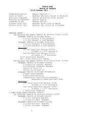
manual for commanders of infantry platoons. - US Army Combined ...
manual for commanders of infantry platoons. - US Army Combined ...
manual for commanders of infantry platoons. - US Army Combined ...

Create successful ePaper yourself
Turn your PDF publications into a flip-book with our unique Google optimized e-Paper software.
~M~ASN~tTA POR;3t~ ~~CO1M&TMADI~ ~S OF :'INF;ANTRY. PLATOONS. 119<br />
the othrer 'eye. Slight rotationsx <strong>of</strong> the per~iscope ab~ou~t its axis<br />
makres possible, byi groping, the superp~osition <strong>of</strong> the two fields.<br />
The relief <strong>of</strong> features t~hen suddenly becomecs extrazordinary andl<br />
different <strong>for</strong>eground~s detach t~hemselv-ersfr.oml each other wvithi<br />
igreata clearness. Rnecognition <strong>of</strong> mroving 01)jects onl the horizon<br />
is. also: facilitated~.<br />
3. Comparss-Th·e blue end <strong>of</strong> the needle indlicates iwh may.z~<br />
n~etic nzorth.. Compasses~ are graduanted fr~omi 0" to 3d()" (or<br />
from 0 to 400 gradces, or fr'oml 0 to 6,400 mlils) in~ tbe d'ir~ection o~<br />
the fig~ures on a clock. The line 0-180 (or 0-200? or 0 3,20·0, de~<br />
pending on the type), w-ihich generally b~ears5the iildications N~. S.,<br />
becomes the geographic north and southl line when the blue<br />
needle point is (<strong>for</strong> PaiI~is) 1.370 (15: g1:rades or 240 miils) to the<br />
left <strong>of</strong> the 0 <strong>of</strong> the compass. Thle conmpass mzost w-idely ulsedl is<br />
one writh a. needle i1- inches lonlg andth l-e bottoml <strong>of</strong> wlhich,<br />
moving with slight friction .on the rest <strong>of</strong> the box, carries a<br />
large black direction arrowi~,codncentric w-ith the magnetic nee~lle.<br />
There is added'a sm~all cop~per l~rotraetor. The precisioni <strong>of</strong> the<br />
mneasuremzentf <strong>of</strong> angles is in proportion to the length <strong>of</strong> the<br />
needle. The needl~e is influenced by the pr~esence <strong>of</strong> iron<br />
(helmet). i<br />
To orient a mnap.-Place thne compassr on the mapg, tile 0-180<br />
line on the meridia~n. Turn tile manp car-rying the comnpass until<br />
the blue point markl'ls the proper d~eclination. Thle mnap is t-hen<br />
oirientedl.<br />
If, inllstea(1 <strong>of</strong> mkeridia~ns being mark:·edl on t-he ma~tp, an arrow~T<br />
indicates the true northl (N.~ G.), place the compa~ss so thac't the<br />
0-180 line! coincides wTith~ the d'Iirection <strong>of</strong> the arrows. Trnr l<br />
t-he mapD bearing thle compass until thle lleedlle indlicate~s thle<br />
d~eclination. If thle margnetic north is given, place, ltile 0-180O<br />
l~ine coincident in dlirect-iont wTith it andl turn thle mapl wLith the<br />
compass' till the needle is a~t 0. Tlhis dispenses; w\ith thle neces<br />
~it;y <strong>for</strong> laying <strong>of</strong>f the dleclination w~it~h thle needile, thle (iodlinetion<br />
varying wititl the lo'cality.' (Tr~anslator's note: TIhe ab~ove<br />
w~ill only give correct r·esults wrhen the (leclinationlaid <strong>of</strong>f is the<br />
true dleclination <strong>of</strong> the l~oca~lit-y in wrhichl the mnap is being used;<br />
or, int the last: case, wihenrtile ma~gnetic N, and~ 8. line indicattedt<br />
B~n tile. map 'is the true magnetic 'meridia~n <strong>for</strong> the place in; w~hich<br />
the map is uxsed.)