Price 28.00 yen
Price 28.00 yen
Price 28.00 yen

You also want an ePaper? Increase the reach of your titles
YUMPU automatically turns print PDFs into web optimized ePapers that Google loves.
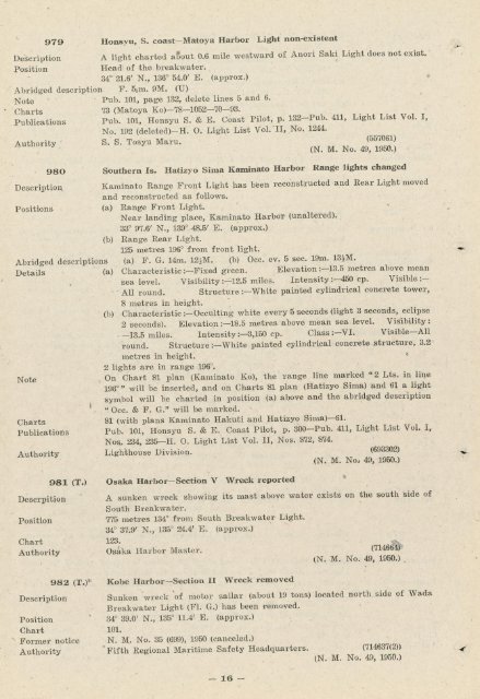
979 Honsyu, S. coast-Matoya Harbor Light non-existent<br />
Description A light charted aUout 0.6 mile westward of Anori Saki Light does not exist.<br />
Position Headl of the breakwater.<br />
34° 21.6' N., 136° 54.0' E. (approx.)<br />
Abridged description F. 55m. 9M. (U)<br />
Note Pub. 101, page 132, delete lines 5 and 6.<br />
Charts 73 (Matoya Ko)-78-1052-70-93.<br />
Publications Pub. 101, Honsyu S. & E. Coast Pilot, p. 132-Pub. 411, Light List Vol. I,<br />
No. 192 (deleted)-H. O. Light List Vol. II, No. 1244.<br />
A uthority S. S. Tosyu Maru. (557061)<br />
AUtnonty ^ M^No^^ im)<br />
98O<br />
Description<br />
Positions<br />
Details<br />
Southern Is. Hatizyo Sima Kaminato Harbor Range lights changed<br />
Kaminato Range Front Light has been reconstructed and Rear Light moved<br />
and reconstructed as follows.<br />
(a) Range Front Light. , v<br />
Near landing place, Kaminato Harbor (unaltered).<br />
33° 97.6' N., 139° 48.5' E. (approx.)<br />
(b) Range Rear Light.<br />
Abridged descriptions<br />
125<br />
(a)<br />
metres<br />
F. G.<br />
196° from<br />
14m. 12]M.<br />
front lisrht.<br />
(b) Occ. ev. 5 sec. 19m. 13|M.<br />
Note<br />
Charts<br />
Publications<br />
Authority<br />
Descrpition<br />
Position<br />
Chart<br />
Authority<br />
Description<br />
981 (T.)<br />
982 (T.)*<br />
Position<br />
Chart<br />
Former notice<br />
Authority<br />
(a)<br />
(b)<br />
Characteristic :-Fixed green. naevaiion ;-±0.0u?uj.c awvc wau<br />
sea level. Visibility :-12.5 miles. Intensity :-450 cp. Visible :-<br />
All round. Structure :-White painted cylindrical concrete tower,<br />
8 metres in height.<br />
Characteristic :-Occulting white every 5 seconds (light 3 seconds, eclipse<br />
2 seconds). Elevation2-18.5 metres above mean sea level. Visibility:<br />
__T5*k á"iw Tntpnsitv :-3.150 cd. Class :--VI. Visible-All<br />
round. Structure :-White painted cylindrical concrete structure, 3.2<br />
metres in height. *<br />
2 lights are in range 196°.<br />
On Chart 81 plan (Kaminato Ko), the range line marked u2 Lts. in line<br />
198°" will be inserted, and on Charts 81 plan (Hatizyo Sima) "and 61 a light<br />
symbol will be charted in position (a) above and the abridged description<br />
"Occ. & F. G." will be marked. -<br />
81 (with plans Kaminato Hakuti and Hatizyo Sima)--81.<br />
Pub. 101, Honsyu S. & E. Coast Pilot, p. 300-Pub. 411, Light List Vol. I,<br />
Nos.. 234, 235-H. O. Light List Vol. II, Nos. 872, 874.<br />
Lighthouse Division. (693302)<br />
(N. M. No, 49, 1950.)<br />
Osaka Harbor-Section V Wreck reported %<br />
A sunken wreck showing its mast above water exists on the south side of<br />
South Breakwater.<br />
775 metres 134° from South Breakwater Light.<br />
34° 37.9' N., 135° 24.4' E. (approx.)<br />
123.<br />
Osaka Harbor Master.<br />
~ (N. M. No. 49, 1950.)<br />
Kobe Harbor-Section II Wreck removed<br />
Sunken wreck %of motor sailar (about 19 tons) located north.side of Wada<br />
Breakwater Light (Fl. G.) has been removed.<br />
34° 39.0' N., 135° ll.4' E. (approx.)<br />
101.<br />
N. M. No. 35 (699), 1950 (canceled.)<br />
Fifth Regional Maritime Safety Headquarters. (714637(2))<br />
(N. M. No. 49, 1950.)<br />
-16-