Price 28.00 yen
Price 28.00 yen
Price 28.00 yen
You also want an ePaper? Increase the reach of your titles
YUMPU automatically turns print PDFs into web optimized ePapers that Google loves.
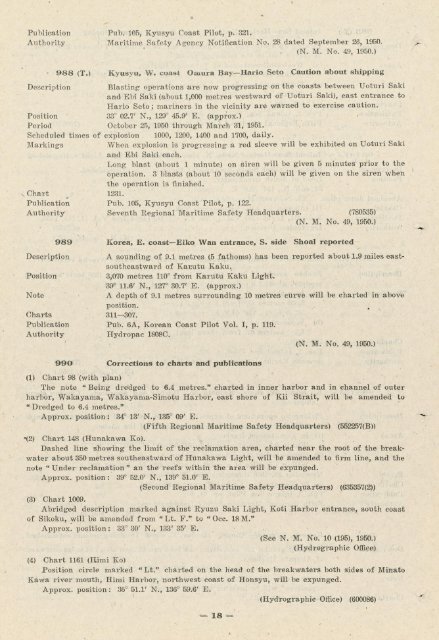
Publication Pub. 105, Kyusyu Coast Pilot, p. 321.<br />
Authority Maritime Safety Agency Notification No. 28 dated September 26, 1950.<br />
(N. M. No. 49, 1950.)<br />
988 (T.) Kyusyu, W. coast Omura Bay-Hario Seto Caution about shipping<br />
Description Blasting operations are now progressing on the coasts between Uoturi Saki<br />
and Ebi Saki (about 1,000 metres westward of Uoturi Saki), east entrance to<br />
Hario Seto ; mariners in the vicinity are warned to exercise caution.<br />
Position 33° 02.7' N., 129° 45.9' E. (approx.)<br />
Period October 25, 1950 through March 31, 1951.<br />
Scheduled times of explosion 1000, 1200, 1400 and 1700, daily.<br />
Markings When explosion is progressing a red sleeve will be exhibited on Uoturi Saki<br />
and Ebi Saki each.<br />
Long blast (about 1 minute) on siren will be given 5 minutes1prior to the<br />
operation. 3 blasts (about 10 seconds each) will be given on the siren when<br />
the operation is finished,<br />
x Chart t 1231.<br />
Publication Pub. 105, Kyusyu Coast Pilot, p. 122.<br />
Authority Seventh Regional Maritime Safety -Headquarters. (780535)<br />
(N. M. No. 49, 1950.)<br />
989 Korea, E. coast-Eiko Wan entrance, S. side Shoal reported<br />
Description A sounding of 9.1 metres (5 fathoms) has been reported about 1.9 miles eastsoutheastward<br />
of Kauutu Kaku.<br />
Position 3,070 metres 110° from Karutu Kaku Light.<br />
39P ll.6' N., 127° 30.7' E. (approx.)<br />
Note A depth of 9.1 metres surrounding 10 metres curve will be charted in above<br />
position.<br />
C harts 311-307.<br />
Publication Pub. 6A, Korean Coast Pilot Vol. I, p. 119.<br />
Authority Hydropac 1808C.<br />
(N. M. No. 49, 1950.)<br />
990 Corrections to charts and publications<br />
(1) Chart 98 (with plan)<br />
The note "Being dredged to 6.4 metres." charted in inner harbor and in channel of outer<br />
harbor, Wakayama, Wakayama-Simotu Harbor, east shore of Kii Strait, will be amended to<br />
" Dredged to 6.4 metres."<br />
Approx. position: 34° 13' N., 135° 09' E.<br />
(Fifth Regional Maritime Safety Headquarters) (552257(B))<br />
\2) Chart 148 (Hunakawa Ko).. H.,<br />
Dashed line showing the limit of the reclamation area, charted near the root of the breakwater<br />
about 350 metres southeastward of Hunakawa Light, will be amended to firm line, and the<br />
note " Under reclamation" an the reefs within the area will be expunged.<br />
Approx. position: 39° 52.0' N., 139° 51.0' E.<br />
(Second Regional Maritime Safety Headquarters) (635357(2))<br />
(3) Chart 1009.<br />
Abridged description marked against Ryuzu Saki Light, Koti Harbor entrance, south coast<br />
of Sikoku, will be amended from "Lt. F." to "Occ. 18M.n<br />
Approx'. position: 33° 30' N., 133° 35' E.<br />
(See N. M. No. 10 (195), 1950.)<br />
(Hydrographic Office)<br />
(4) Chart 1161 (Himi Ko)<br />
Position circle marked "Lt." charted on the head of the breakwaters both sides of Minato<br />
Kawa river mouth, Himi Harbor, northwest coast of Honsyu, will be expunged.<br />
Approx. position: 36° 51.1' N., 136° 59.6' E.<br />
1 (Hydrographic Office) (600086)<br />
,18-


