Price 28.00 yen
Price 28.00 yen
Price 28.00 yen

Create successful ePaper yourself
Turn your PDF publications into a flip-book with our unique Google optimized e-Paper software.
Description<br />
Areas<br />
Charts<br />
Publication.<br />
Authority<br />
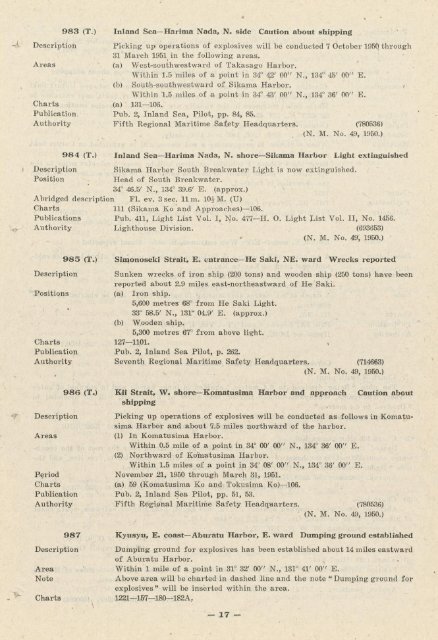
983 (T.)<br />
Inland Sea-Harima Nada, N. side Caution about shipping<br />
Picking up operations of explosives will be conducted 7 October 1950 through<br />
31 March 1951 in the following areas.<br />
(a) West-southwestward of Takasago Harbor.<br />
Within 1.5 miles of a point in 34° 42' 00" N., 134° 45' 00" E.<br />
(b) South-southwestward of Sikama Harbor. ' /<br />
Within 1.5 miles of a point in 34° 43' 00" N., 134° 36' 00" E.<br />
(a) 131-106.<br />
Pub. 2, Inland Sea, Pilot, pp. 84, 85.<br />
Fifth Regional Maritime Safety Headquarters. (780536)<br />
(N. M. No. 49, 1950.)<br />
984 (T.) Inland Sea-Harima Nada, N. shore-Sikama Harbor Light extinguished<br />
Description Sikama Harbor South Breakwater Light is now extinguished.<br />
Position Head of South Breakwater.<br />
34° 46.5' N., 134° 39.6' E. (approx.)<br />
Abridged description Fl. ev. 3sec. llm. 10£M. (U)<br />
Charts 111 (Sikama Ko and Approaches)-10S.<br />
Publications Pub. 411, Light List Vol. I, No. 477-H. O. Light List Vol. II, No. 1456.<br />
Authority Lighthouse Division. (693853)<br />
(N. M. No. 49, 1950.)<br />
Description<br />
Positions<br />
Charts<br />
Publication<br />
Authority<br />
*/~ Description<br />
Areas<br />
Feriod<br />
Charts<br />
Publication<br />
Authority<br />
985 (TO<br />
986 (T.)<br />
Simonoseki Strait, E. entrance-He Saki, NE. ward Wrecks reported<br />
Sunken wrecks of iron ship (200 tons) and wooden ship (250 tons) have been<br />
reported about 2.9 miles east-northeastward of He Saki.<br />
(a) Iron ship.<br />
5,600 metres 68° from He Saki Light.<br />
33° 58.5' N., 131° 04.9' E. (approx.)<br />
(b) Wooden ship.<br />
5,300 metres 67° from above light.<br />
127-1101.<br />
Pub. 2, Inland Sea Pilot, p. 262.<br />
Seventh Regional Maritime Safety Headquarters. (714663)<br />
(N. M. No. 49, 1950.)<br />
Kii Strait, W. shore-Komatusima Harbor and approach Caution about<br />
shipping<br />
Picking up operations of explosives will be conducted as follows in Komatusima<br />
Harbor and about 7.5 miles northward of the harbor.<br />
(1) In Komatusima Harbor.<br />
Within 0.5 mile of a point in 34° 00' 00" N., 134° 36'~00" E.<br />