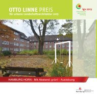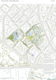
OTTO LINNE PREIS - luchterhandt
OTTO LINNE PREIS - luchterhandt
OTTO LINNE PREIS - luchterhandt

You also want an ePaper? Increase the reach of your titles
YUMPU automatically turns print PDFs into web optimized ePapers that Google loves.
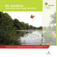
“By the Alster, by<br />
the Elbe, by the Bill,<br />
everyone can do just<br />
whatever he will.<br />
That is the refrain of a Low German folk song from<br />
Hamburg.<br />
The rhyme contains two core messages:<br />
Hamburg lies on three rivers! The third, the Bille,<br />
is barely recognizable as a river, at least not in the<br />
review area.<br />
In the past, people did do whatever they wanted<br />
with and around the Bille, most alterations being<br />
dictated by the demands of trade and industry.<br />
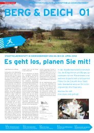
Towards the objective of re-casting the Bille as being, as it were, part of a “Gateway to the City” the following impressions<br />
need to be countered:<br />
• The natural scenery of the Bille is no longer recognizable. But it still, as in the past, flows<br />
through Hammerbrook (brook is a Low German word for the low-lying area surrounding<br />
water), in front of the northern Horner Geest. The Bille is used mostly for transportation or for<br />
supplying trade and industrial sites from the water.<br />
• Very few parts of its banks still offer public access and can be used for leisure pursuits.<br />
The space is characterized and dominated by roads, most of them several lanes wide, traffic intersections<br />
and the mainline railway.<br />
Currently a green space corridor is being developed from the north along the side of the flood control basin. However<br />
there is no bridge over the Bille apart from on the roads.<br />
An important part of the riverbank where the flood control basin empties into the Bille is occupied by the recycling<br />
centre and thus closed to the public. There is considerable noise nuisance.<br />
Note:<br />
The green finger along the flood control basin on the northern edge used to be a park; called the “Stoltenpark”, it<br />
was laid out in 1920 by Hamburg’s director of gardens Otto Linne and until the night bombing raids in the 2nd World<br />
War was a recreation spot for the residents of the housing areas then situated to the east.”<br />
Dieter Schramm, Deutsche Gesellschaft für Gartenkunst und Landschaftskultur e.V. Hamburg / Schleswig-Holstein section (German society for gardens<br />
and landscapes)