June 1 – 15, 2012 - Office of Planning and Research - State of ...
June 1 – 15, 2012 - Office of Planning and Research - State of ...
June 1 – 15, 2012 - Office of Planning and Research - State of ...

Create successful ePaper yourself
Turn your PDF publications into a flip-book with our unique Google optimized e-Paper software.
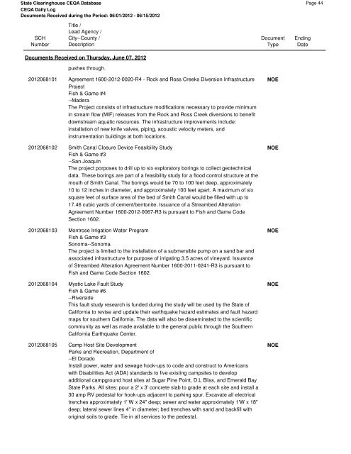
<strong>State</strong> Clearinghouse CEQA Database<br />
CEQA Daily Log<br />
Documents Received during the Period: 06/01/<strong>2012</strong> - 06/<strong>15</strong>/<strong>2012</strong><br />
SCH<br />
Number<br />
Title /<br />
Lead Agency /<br />
City--County /<br />
Description<br />
Documents Received on Thursday, <strong>June</strong> 07, <strong>2012</strong><br />
pushes through.<br />
<strong>2012</strong>068101 Agreement 1600-<strong>2012</strong>-0020-R4 - Rock <strong>and</strong> Ross Creeks Diversion Infrastructure<br />
Project<br />
Fish & Game #4<br />
--Madera<br />
The Project consists <strong>of</strong> infrastructure modifications necessary to provide minimum<br />
in stream flow (MIF) releases from the Rock <strong>and</strong> Ross Creek diversions to benefit<br />
downstream aquatic resources. The infrastructure improvements include:<br />
installation <strong>of</strong> new knife valves, piping, acoustic velocity meters, <strong>and</strong><br />
instrumentation buildings at both locations.<br />
<strong>2012</strong>068102 Smith Canal Closure Device Feasibility Study<br />
Fish & Game #3<br />
--San Joaquin<br />
The project porposes to drill up to six exploratory borings to collect geotechnical<br />
data. These borings are part <strong>of</strong> a feasibility study for a flood control structure at the<br />
mouth <strong>of</strong> Smith Canal. The borings would be 70 to 100 feet deep, approximately<br />
10 to 12 inches in diameter, <strong>and</strong> approximately 100 feet apart. A maximum <strong>of</strong> six<br />
square feet <strong>of</strong> surface area <strong>of</strong> the bed <strong>of</strong> Smith Canal would be filled with up to<br />
17.46 cubic yards <strong>of</strong> cement/bentonite. Issuance <strong>of</strong> a Streambed Alteration<br />
Agreement Number 1600-<strong>2012</strong>-0067-R3 is pursuant to Fish <strong>and</strong> Game Code<br />
Section 1602.<br />
<strong>2012</strong>068103 Montrose Irrigation Water Program<br />
Fish & Game #3<br />
Sonoma--Sonoma<br />
The project is limited to the installation <strong>of</strong> a submersible pump on a s<strong>and</strong> bar <strong>and</strong><br />
associated infrastructure for purpose <strong>of</strong> irrigating 3.5 acres <strong>of</strong> vineyard. Issuance<br />
<strong>of</strong> Streambed Alteration Agreement Number 1600-2011-0241-R3 is pursuant to<br />
Fish <strong>and</strong> Game Code Section 1602.<br />
<strong>2012</strong>068104 Mystic Lake Fault Study<br />
Fish & Game #6<br />
--Riverside<br />
This fault study research is funded during the study will be used by the <strong>State</strong> <strong>of</strong><br />
California to revise <strong>and</strong> update their earthquake hazard estimates <strong>and</strong> fault hazard<br />
maps for southern California. The data will also be disseminated to the scientific<br />
community as well as made available to the general public through the Southern<br />
California Earthquake Center.<br />
<strong>2012</strong>068105 Camp Host Site Development<br />
Parks <strong>and</strong> Recreation, Department <strong>of</strong><br />
--El Dorado<br />
Install power, water <strong>and</strong> sewage hook-ups to code <strong>and</strong> construct to Americans<br />
with Disabilities Act (ADA) st<strong>and</strong>ards to five existing campsites to develop<br />
additional campground host sites at Sugar Pine Point, D.L Bliss, <strong>and</strong> Emerald Bay<br />
<strong>State</strong> Parks. All sites: pour a 2' x 3' concrete slab to grade at each site <strong>and</strong> install a<br />
30 amp RV pedestal for hook-ups adjacent to parking spur. Excavate all electrical<br />
trenches approximately 1' W x 24" deep; sewer <strong>and</strong> water approximately 1'W x 18"<br />
deep; lateral sewer lines 4" in diameter; bed trenches with s<strong>and</strong> <strong>and</strong> backfill with<br />
original soils to grade. Tie in all services to the pedestal.<br />
Document<br />
Type<br />
NOE<br />
NOE<br />
NOE<br />
NOE<br />
NOE<br />
Ending<br />
Date<br />
Page 44