

i Detection of Smoke and Dust Aerosols Using Multi-sensor Satellite ...
i Detection of Smoke and Dust Aerosols Using Multi-sensor Satellite ...
i Detection of Smoke and Dust Aerosols Using Multi-sensor Satellite ...

Create successful ePaper yourself
Turn your PDF publications into a flip-book with our unique Google optimized e-Paper software.
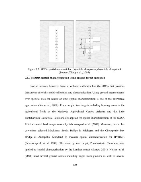
Figure 7.3: SRCA spatial mode reticles. (a) reticle along-scan; (b) reticle along-track<br />
(Source: Xiong et al., 2005).<br />
7.1.3 MODIS spatial characterization using ground target approach<br />
Not all <strong>sensor</strong>s, however, have an onboard calibrator like the SRCA that provides<br />
instrument on-orbit spatial calibration <strong>and</strong> characterization. <strong>Using</strong> ground measurements<br />
over specific sites for <strong>sensor</strong> on-orbit spatial characterization is one <strong>of</strong> the alternative<br />
approaches (Xie et al., 2008). For example, two targets including burning areas in the<br />
agricultural fields at the Maricopa Agricultural Center, Arizona <strong>and</strong> the Lake<br />
Pontchartrain Causeway, Louisiana are applied for spatial characterization <strong>of</strong> the NASA<br />
EO-1 advanced l<strong>and</strong> imager <strong>sensor</strong> by Schowengerdt et al. (2002). Moreover, he <strong>and</strong> his<br />
coworkers selected Mackinaw Straits Bridge in Michigan <strong>and</strong> the Chesapeake Bay<br />
Bridge at Annapolis, Maryl<strong>and</strong> to measure spatial characterization for HYDICE<br />
(Schowengerdt et al, 1996). The same ground target, Pontchartrain Causeway, was<br />
applied to spatial characterization by the L<strong>and</strong>sat <strong>sensor</strong> (Storey, 2001). Nelson et al.<br />
(2001) used several ground scenes including edges from glaciers as well as several<br />
100
![[Sample B: Approval/Signature Sheet] - George Mason University](https://img.yumpu.com/21978828/1/190x245/sample-b-approval-signature-sheet-george-mason-university.jpg?quality=85)
![[Sample B: Approval/Signature Sheet] - George Mason University](https://img.yumpu.com/18694905/1/190x245/sample-b-approval-signature-sheet-george-mason-university.jpg?quality=85)
![[Sample B: Approval/Signature Sheet] - George Mason University](https://img.yumpu.com/18694552/1/189x260/sample-b-approval-signature-sheet-george-mason-university.jpg?quality=85)
![[Sample B: Approval/Signature Sheet] - George Mason University](https://img.yumpu.com/18694474/1/190x245/sample-b-approval-signature-sheet-george-mason-university.jpg?quality=85)