

i Detection of Smoke and Dust Aerosols Using Multi-sensor Satellite ...
i Detection of Smoke and Dust Aerosols Using Multi-sensor Satellite ...
i Detection of Smoke and Dust Aerosols Using Multi-sensor Satellite ...

Create successful ePaper yourself
Turn your PDF publications into a flip-book with our unique Google optimized e-Paper software.
(a) (b)<br />
ENVI RGB image (500m spatial resolution)<br />
(d)<br />
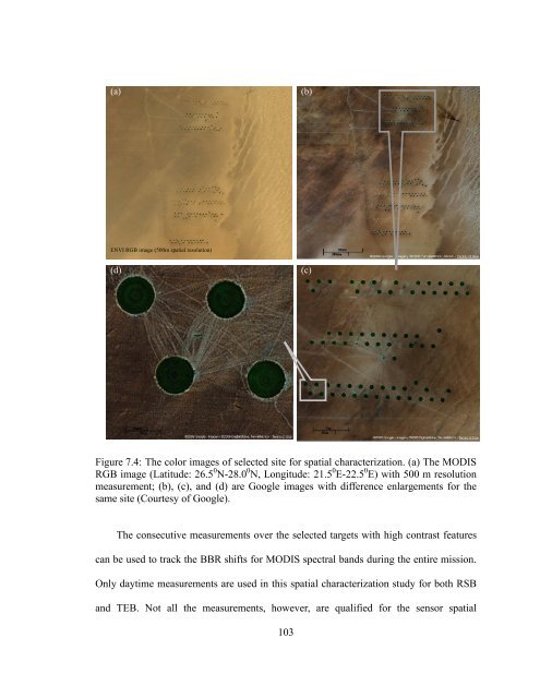
Figure 7.4: The color images <strong>of</strong> selected site for spatial characterization. (a) The MODIS<br />
RGB image (Latitude: 26.5 0 N-28.0 0 N, Longitude: 21.5 0 E-22.5 0 E) with 500 m resolution<br />
measurement; (b), (c), <strong>and</strong> (d) are Google images with difference enlargements for the<br />
same site (Courtesy <strong>of</strong> Google).<br />
The consecutive measurements over the selected targets with high contrast features<br />
can be used to track the BBR shifts for MODIS spectral b<strong>and</strong>s during the entire mission.<br />
Only daytime measurements are used in this spatial characterization study for both RSB<br />
<strong>and</strong> TEB. Not all the measurements, however, are qualified for the <strong>sensor</strong> spatial<br />
103<br />
(c)
![[Sample B: Approval/Signature Sheet] - George Mason University](https://img.yumpu.com/21978828/1/190x245/sample-b-approval-signature-sheet-george-mason-university.jpg?quality=85)
![[Sample B: Approval/Signature Sheet] - George Mason University](https://img.yumpu.com/18694905/1/190x245/sample-b-approval-signature-sheet-george-mason-university.jpg?quality=85)
![[Sample B: Approval/Signature Sheet] - George Mason University](https://img.yumpu.com/18694552/1/189x260/sample-b-approval-signature-sheet-george-mason-university.jpg?quality=85)
![[Sample B: Approval/Signature Sheet] - George Mason University](https://img.yumpu.com/18694474/1/190x245/sample-b-approval-signature-sheet-george-mason-university.jpg?quality=85)