Climate Change and Switzerland 2050 - OcCC - SCNAT
Climate Change and Switzerland 2050 - OcCC - SCNAT
Climate Change and Switzerland 2050 - OcCC - SCNAT

You also want an ePaper? Increase the reach of your titles
YUMPU automatically turns print PDFs into web optimized ePapers that Google loves.
<strong>Climate</strong> <strong>Change</strong> <strong>and</strong> Switzerl<strong>and</strong> <strong>2050</strong> | L<strong>and</strong> ecosystems 27<br />
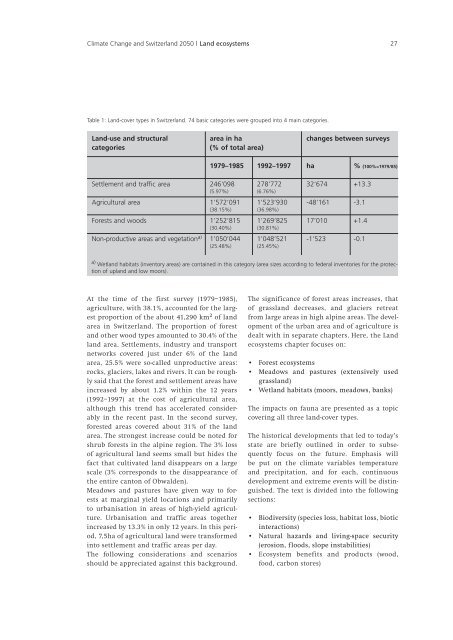
Table 1: L<strong>and</strong>-cover types in Switzerl<strong>and</strong>. 74 basic categories were grouped into 4 main categories.<br />
L<strong>and</strong>-use <strong>and</strong> structural<br />
categories<br />
Settlement <strong>and</strong> traffic area<br />
Agricultural area<br />
Forests <strong>and</strong> woods<br />
Non-productive areas <strong>and</strong> vegetation a)<br />
area in ha<br />
(% of total area)<br />
At the time of the first survey (1979–1985),<br />
agriculture, with 38.1%, accounted for the largest<br />
proportion of the about 41,290 km 2 of l<strong>and</strong><br />
area in Switzerl<strong>and</strong>. The proportion of forest<br />
<strong>and</strong> other wood types amounted to 30.4% of the<br />
l<strong>and</strong> area. Settlements, industry <strong>and</strong> transport<br />
networks covered just under 6% of the l<strong>and</strong><br />
area, 25.5% were so-called unproductive areas:<br />
rocks, glaciers, lakes <strong>and</strong> rivers. It can be roughly<br />
said that the forest <strong>and</strong> settlement areas have<br />
increased by about 1.2% within the 12 years<br />
(1992–1997) at the cost of agricultural area,<br />
although this trend has accelerated considerably<br />
in the recent past. In the second survey,<br />
forested areas covered about 31% of the l<strong>and</strong><br />
area. The strongest increase could be noted for<br />
shrub forests in the alpine region. The 3% loss<br />
of agricultural l<strong>and</strong> seems small but hides the<br />
fact that cultivated l<strong>and</strong> disappears on a large<br />
scale (3% corresponds to the disappearance of<br />
the entire canton of Obwalden).<br />
Meadows <strong>and</strong> pastures have given way to forests<br />
at marginal yield locations <strong>and</strong> primarily<br />
to urbanisation in areas of high-yield agriculture.<br />
Urbanisation <strong>and</strong> traffic areas together<br />
increased by 13.3% in only 12 years. In this period,<br />
7,5ha of agricultural l<strong>and</strong> were transformed<br />
into settlement <strong>and</strong> traffic areas per day.<br />
The following considerations <strong>and</strong> scenarios<br />
should be appreciated against this background.<br />
1979–1985 1992–1997<br />
246'098 278'772<br />
(5.97%) (6.76%)<br />
1’572’091 1’523’930<br />
(38.15%) (36.98%)<br />
1’252’815 1’269’825<br />
(30.40%) (30.81%)<br />
1’050’044 1’048’521<br />
(25.48%) (25.45%)<br />
The significance of forest areas increases, that<br />
of grassl<strong>and</strong> decreases, <strong>and</strong> glaciers retreat<br />
from large areas in high alpine areas. The development<br />
of the urban area <strong>and</strong> of agriculture is<br />
dealt with in separate chapters. Here, the L<strong>and</strong><br />
ecosystems chapter focuses on:<br />
• Forest ecosystems<br />
• Meadows <strong>and</strong> pastures (extensively used<br />
grassl<strong>and</strong>)<br />
• Wetl<strong>and</strong> habitats (moors, meadows, banks)<br />
The impacts on fauna are presented as a topic<br />
covering all three l<strong>and</strong>-cover types.<br />
The historical developments that led to today’s<br />
state are briefly outlined in order to subsequently<br />
focus on the future. Emphasis will<br />
be put on the climate variables temperature<br />
<strong>and</strong> precipitation, <strong>and</strong> for each, continuous<br />
development <strong>and</strong> extreme events will be distinguished.<br />
The text is divided into the following<br />
sections:<br />
•<br />
•<br />
•<br />
changes between surveys<br />
ha % (100%=1979/85)<br />
32'674 +13.3<br />
-48’161 -3.1<br />
17’010 +1.4<br />
-1’523 -0.1<br />
a) Wetl<strong>and</strong> habitats (inventory areas) are contained in this category (area sizes according to federal inventories for the protec-<br />
tion of upl<strong>and</strong> <strong>and</strong> low moors).<br />
Biodiversity (species loss, habitat loss, biotic<br />
interactions)<br />
Natural hazards <strong>and</strong> living-space security<br />
(erosion, floods, slope instabilities)<br />
Ecosystem benefits <strong>and</strong> products (wood,<br />
food, carbon stores)