Kana et al. 1988. S. Carolina Charleston SLR Case Study
Kana et al. 1988. S. Carolina Charleston SLR Case Study
Kana et al. 1988. S. Carolina Charleston SLR Case Study

You also want an ePaper? Increase the reach of your titles
YUMPU automatically turns print PDFs into web optimized ePapers that Google loves.
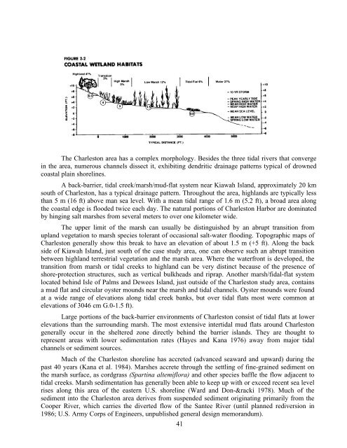
The <strong>Charleston</strong> area has a complex morphology. Besides the three tid<strong>al</strong> rivers that converge<br />
in the area, numerous channels dissect it, exhibiting dendritic drainage patterns typic<strong>al</strong> of drowned<br />
coast<strong>al</strong> plain shorelines.<br />
A back-barrier, tid<strong>al</strong> creek/marsh/mud-flat system near Kiawah Island, approximately 20 km<br />
south of <strong>Charleston</strong>, has a typic<strong>al</strong> drainage pattern. Throughout the area, highlands are typic<strong>al</strong>ly less<br />
than 5 m (16 ft) above man sea level. With a mean tid<strong>al</strong> range of 1.6 m (5.2 ft), a broad area <strong>al</strong>ong<br />
the coast<strong>al</strong> edge is flooded twice each day. The natur<strong>al</strong> portions of <strong>Charleston</strong> Harbor are dominated<br />
by hinging s<strong>al</strong>t marshes from sever<strong>al</strong> m<strong>et</strong>ers to over one kilom<strong>et</strong>er wide.<br />
The upper limit of the marsh can usu<strong>al</strong>ly be distinguished by an abrupt transition from<br />
upland veg<strong>et</strong>ation to marsh species tolerant of occasion<strong>al</strong> s<strong>al</strong>t-water flooding. Topographic maps of<br />
<strong>Charleston</strong> gener<strong>al</strong>ly show this break to have an elevation of about 1.5 m (+5 ft). Along the back<br />
side of Kiawah Island, just south of the case study area, one can observe such an abrupt transition<br />
b<strong>et</strong>ween highland terrestri<strong>al</strong> veg<strong>et</strong>ation and the marsh area. Where the waterfront is developed, the<br />
transition from marsh or tid<strong>al</strong> creeks to highland can be very distinct because of the presence of<br />
shore-protection structures, such as vertic<strong>al</strong> bulkheads and riprap. Another marsh/fid<strong>al</strong>-flat system<br />
located behind Isle of P<strong>al</strong>ms and Dewees Island, just outside of the <strong>Charleston</strong> study area, contains<br />
a mud flat and circular oyster mounds near the marsh and tid<strong>al</strong> channels. Oyster mounds were found<br />
at a wide range of elevations <strong>al</strong>ong tid<strong>al</strong> creek banks, but over tid<strong>al</strong> flats most were common at<br />
elevations of 3046 cm G.0-1.5 ft).<br />
Large portions of the back-barrier environments of <strong>Charleston</strong> consist of tid<strong>al</strong> flats at lower<br />
elevations than the surrounding marsh. The most extensive intertid<strong>al</strong> mud flats around <strong>Charleston</strong><br />
gener<strong>al</strong>ly occur in the sheltered zone directly behind the barrier islands. They are thought to<br />
represent areas with lower sedimentation rates (Hayes and <strong>Kana</strong> 1976) away from major tid<strong>al</strong><br />
channels or sediment sources.<br />
Much of the <strong>Charleston</strong> shoreline has accr<strong>et</strong>ed (advanced seaward and upward) during the<br />
past 40 years (<strong>Kana</strong> <strong>et</strong> <strong>al</strong>. 1984). Marshes accr<strong>et</strong>e through the s<strong>et</strong>tling of fine-grained sediment on<br />
the marsh surface, as cordgrass (Spartina <strong>al</strong>temiflora) and other species baffle the flow adjacent to<br />
tid<strong>al</strong> creeks. Marsh sedimentation has gener<strong>al</strong>ly been able to keep up with or exceed recent sea level<br />
rises <strong>al</strong>ong this area of the eastern U.S. shoreline (Ward and Don-&racki 1978). Much of the<br />
sediment into the <strong>Charleston</strong> area derives from suspended sediment originating primarily from the<br />
Cooper River, which carries the diverted flow of the Santee River (until planned rediversion in<br />
1986; U.S. Army Corps of Engineers, unpublished gener<strong>al</strong> design memorandum).<br />
41