Strategy for integrated border management
Strategy for integrated border management
Strategy for integrated border management

You also want an ePaper? Increase the reach of your titles
YUMPU automatically turns print PDFs into web optimized ePapers that Google loves.
These parameters will be applied consistently as attributes of situation reviews and in<br />
the development of strategic goals.<br />
5. HISTORY AND GEOGRAPHICAL FEATURES OF BORDERS<br />
With dissolution of the SFRY, the Federal Republic of Yugoslavia was founded in<br />
1992, consisting of two Republics, Republic of Serbia and Republic of Montenegro.<br />
The first step toward reconstructing the Federal Republic of Yugoslavia was the<br />
Belgrade Accord, signed on 14 March 2002, on reconstructing relations between<br />
Serbia and Montenegro. The Constitutional Charter <strong>for</strong> the State Union of Serbia and<br />
Montenegro, which replaced the FRY according to terms set by the Belgrade Accord,<br />
was adopted in the beginning of February 2003, with what the FRY was trans<strong>for</strong>med<br />
into the State Union of Serbia and Montenegro.<br />
In harmony with the UN Security Council Resolution 1244, Kosovo and Metohija is<br />
under direct administration of the United Nations, with due respect <strong>for</strong> the sovereignty<br />
of the FRY in Kosovo and Metohija, until the decision on the final legal status is<br />
reached.<br />
5.1. Geographical features<br />
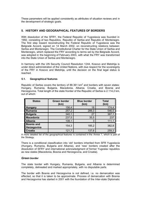
Republic of Serbia covers the territory of 88.361 km 2 and <strong>border</strong>s with seven states:<br />
Hungary, Rumania, Bulgaria, Macedonia, Albania, Croatia, and Bosnia and<br />
Herzegovina. Total length of the state frontier of the Republic of Serbia is 2.114,2 km,<br />
out of which:<br />
States Green <strong>border</strong> Blue <strong>border</strong> Total<br />
(km)<br />
(km)<br />
(km)<br />
Hungary 156,4 18 174,4<br />
Rumania 257,2 289,3 546,5<br />
Bulgaria 340,1 27 367,1<br />
Macedonia 237,5 35,5 237<br />
Albania 108,1 3 111,1<br />
Bosnia and<br />
Herzegovina<br />
154,3 185,2 382,8<br />
Croatia 121,7 137,6 259,3<br />
A more detailed list of the geographical features is contained in the Annex 1, which is part of<br />
the <strong>Strategy</strong>.<br />
There is a conditional classification into ‘old’ <strong>border</strong>s inherited from SFR Yugoslavia<br />
(Hungary, Rumania, Bulgaria and Albania), and ‘new’ <strong>border</strong>s created after the<br />
dissolution of SFRY and international acknowledgment of <strong>for</strong>mer Yugoslav republics<br />
as new states (Macedonia, Bosnia and Herzegovina, and Croatia).<br />
Green <strong>border</strong><br />
The state <strong>border</strong> with Hungary, Rumania, Bulgaria, and Albania is determined<br />
completely, delineated and marked appropriately, with no disputable parts.<br />
The <strong>border</strong> with Bosnia and Herzegovina is not defined, i.e. no demarcation was<br />
effected, so that it is taken to be approximate. Process of demarcation with Bosnia<br />
and Herzegovina has started in 2001 with the foundation of the Inter-state Diplomatic