Strategy for integrated border management
Strategy for integrated border management
Strategy for integrated border management

Create successful ePaper yourself
Turn your PDF publications into a flip-book with our unique Google optimized e-Paper software.
Commission <strong>for</strong> the State Border Between FRY and B&H, but it is stalled due to<br />
differences in standpoints of the two sides.<br />
Process of demarcation with Croatia is in the preparatory phase, and the cadastre<br />
<strong>border</strong> is treated as an approximate one. Aimed at realizing the procedure of<br />
demarcation, pursuant to the Conclusion of the Government of Serbia of 29.12.2004,<br />
an inter-state diplomatic commission was founded to identify – determine the <strong>border</strong><br />
line and to prepare the Contract on State Frontier Between SCG and Croatia.<br />
Border with Macedonia is determined, but it is still not marked. The process of<br />
marking the <strong>border</strong> is underway.<br />
Along the <strong>border</strong> with Albania, on the part of the state <strong>border</strong> with Macedonia, and<br />
also at the airport “Priština”, the control of crossing the state <strong>border</strong> is per<strong>for</strong>med by<br />
the members of international <strong>for</strong>ces stationed in Kosovo and Metohija, in accordance<br />
with the United Nations Security Council Resolution 1244.<br />
Blue <strong>border</strong><br />
The natural <strong>border</strong> of the Republic of Serbia consists also of three internationally<br />
navigable rivers: the Danube – with Croatia and Rumania, where navigation regime<br />
is regulated by the Convention on Navigation Regime on the Danube; the Sava –<br />
with Bosnia, where navigation regime is regulated by General Agreement on river<br />
basin of the Sava river with Annexes and by Protocol on navigation regime; and the<br />
Tisa, where the navigation regime is regulated by a bi-lateral agreement with<br />
Hungary. Also, the blue <strong>border</strong> with B&H is delineated by the river Drina, but it is not<br />
an international navigable route.<br />
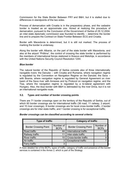
5.2. Types and number of <strong>border</strong> crossing points<br />
There are 71 <strong>border</strong> crossings open on the territory of the Republic of Serbia, out of<br />
which 60 <strong>border</strong> crossings are <strong>for</strong> international traffic (36 road, 11 railway, 3 airport,<br />
and 10 river crossings), 8 <strong>border</strong> crossings are <strong>for</strong> local cross-<strong>border</strong> traffic, 2 <strong>border</strong><br />
crossings are <strong>for</strong> inter-state traffic, and 1 <strong>border</strong> crossing is <strong>for</strong> exceptional traffic.<br />
Border crossings can be classified according to several criteria:<br />
Type of traffic Category of traffic<br />
Border Crossing Point<br />
Number of<br />
BCPs<br />
Border Crossing Point<br />
Number of<br />
BCPs<br />
Road traffic 44 International traffic 59<br />
Railway traffic 11 Inter-state traffic 2<br />
River traffic 10 Cross-<strong>border</strong> traffic 9<br />
Air traffic 3 Exceptional traffic 1<br />
Ferry traffic 3<br />
A more detailed list of the BCPs, types of traffic, category of traffic and presence of the <strong>border</strong><br />
services is contained in the Annex 2, which is part of the <strong>Strategy</strong>