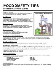
Water Protection Activities in Washtenaw County
Water Protection Activities in Washtenaw County
Water Protection Activities in Washtenaw County

You also want an ePaper? Increase the reach of your titles
YUMPU automatically turns print PDFs into web optimized ePapers that Google loves.
B2 - Plan 2: Huron Cha<strong>in</strong> of Lakes <strong>Water</strong>shed Management<br />
Plan<br />
Plan Date: November 2005<br />
The Huron Cha<strong>in</strong> of Lakes <strong>Water</strong>shed (HCLW) covers 253<br />
square miles (161,919 acres), represent<strong>in</strong>g 28% of the Huron<br />
River watershed. The majority of the watershed lies with<strong>in</strong><br />
Liv<strong>in</strong>gston <strong>County</strong>, with the eastern portions <strong>in</strong> southwest<br />
Oakland <strong>County</strong> and the southern most areas <strong>in</strong> Dexter,<br />
Webster, Northfield and Salem townships <strong>in</strong> <strong>Washtenaw</strong><br />
<strong>County</strong>. With<strong>in</strong> this watershed area, the Huron River flows<br />
southwest for 27 miles through a series of wetlands and lakes<br />
prior to cont<strong>in</strong>u<strong>in</strong>g south through <strong>Washtenaw</strong> <strong>County</strong>.<br />
While the HCLW conta<strong>in</strong>s several areas of high quality natural<br />
habitat, aquatic ecosystems, and recreational opportunities,<br />
analysis of exist<strong>in</strong>g data <strong>in</strong>dicate that the HCLW also has<br />
stretches of medium and low quality waterways that require<br />
mitigation of exist<strong>in</strong>g impairments. Identified impairments<br />
<strong>in</strong>clude: high nutrient load<strong>in</strong>g, altered hydrology,<br />
sedimentation, soil erosion, pathogens, salts, organic<br />
compounds, heavy metals, elevated water temperature and<br />
debris/litter. Additionally, three TMDLs for phosphorus have<br />
been established <strong>in</strong> the watershed for Brighton, Strawberry, and<br />
Ore Lakes. Six TMDLs for other pollutants are scheduled for<br />
future (2007-2013) establishment <strong>in</strong> the watershed. One TMDL<br />
is scheduled for 2009 <strong>in</strong> <strong>Washtenaw</strong> <strong>County</strong> for a “poor macro<br />
<strong>in</strong>vertebrate population” <strong>in</strong> the Horseshoe Lake Outlet Dra<strong>in</strong>.<br />
A total of 96 Best Management Practices (BMPs) are identified<br />
<strong>in</strong> the action plan to mitigate these impairments. Included are<br />
Managerial Actions (ord<strong>in</strong>ances, policies, studies, education,<br />
illicit discharge elim<strong>in</strong>ation, fund<strong>in</strong>g), Vegetative Management<br />
Alternatives (wetlands, buffers, grassed swales, habitat<br />
131<br />
restoration, soil stabilization) and Structural Management<br />
Alternatives (storm water retention/detention bas<strong>in</strong>s,<br />
<strong>in</strong>filtration trenches, culvert ma<strong>in</strong>tenance/repair, grade<br />
stabilization, sediment trapp<strong>in</strong>g). Not all BMPs apply to, or<br />
have been implemented by, all cities, villages and townships<br />
with<strong>in</strong> the HCLW.<br />
B2 Map: