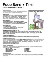
Water Protection Activities in Washtenaw County
Water Protection Activities in Washtenaw County
Water Protection Activities in Washtenaw County

You also want an ePaper? Increase the reach of your titles
YUMPU automatically turns print PDFs into web optimized ePapers that Google loves.
2.0 Groundwater<br />
Groundwater is a vital natural resource <strong>in</strong> <strong>Washtenaw</strong> <strong>County</strong>.<br />
It is used <strong>in</strong> <strong>in</strong>dustry and agriculture, and provides virtually<br />
100% of the dr<strong>in</strong>k<strong>in</strong>g water supply <strong>in</strong> the rural parts of the<br />
<strong>County</strong>.<br />
What is Groundwater?<br />
In the simplest terms<br />
groundwater is water<br />
that comes from the<br />
ground. More<br />
specifically,<br />
groundwater is water<br />
that fills cracks and<br />
spaces between<br />
particles of soil and<br />
rocks. When water fills<br />
all the pores and open<br />
spaces, it’s called the<br />
Groundwater Facts…<br />
Over 50% of <strong>Washtenaw</strong> <strong>County</strong><br />
residents rely on groundwater as<br />
their primary source of dr<strong>in</strong>k<strong>in</strong>g<br />
water.<br />
Approximately one-fifth of the<br />
earth’s fresh water is conta<strong>in</strong>ed<br />
<strong>in</strong> the Great Lakes bas<strong>in</strong>.<br />
Most of <strong>Washtenaw</strong> <strong>County</strong>’s<br />
dr<strong>in</strong>k<strong>in</strong>g water comes from drift<br />
aquifers.<br />
saturated zone. The divid<strong>in</strong>g l<strong>in</strong>e between the saturated zone<br />
and overly<strong>in</strong>g unsaturated rock or sediment is called the water<br />
table. Contrary to what many believe, groundwater doesn’t<br />
generally consist of underground lakes or streams, but rather<br />
fills the irregular space with<strong>in</strong> the rock fractures or between<br />
particles of sand, gravel or clay. Then as the water moves<br />
through the ground, it dissolves some of the naturally occurr<strong>in</strong>g<br />
m<strong>in</strong>erals it contacts. These dissolved m<strong>in</strong>erals give the<br />
groundwater its chemical characteristics, affect<strong>in</strong>g such th<strong>in</strong>gs<br />
as taste and hardness. The most common dissolved m<strong>in</strong>eral<br />
substances are sodium, calcium, magnesium, potassium,<br />
chloride, bicarbonate and sulfate.<br />
When surface water percolates from land areas or streams<br />
through permeable soils <strong>in</strong>to water-hold<strong>in</strong>g rocks that provide<br />
underground storage, it is called groundwater recharge<br />
3<br />
(Map 1). Groundwater can be recharged from ra<strong>in</strong> water that<br />
<strong>in</strong>filtrates from woodlands and surface water features like<br />
wetlands, lakes, and streams. Woodlands, wetlands and<br />
floodpla<strong>in</strong>s provide a filter<strong>in</strong>g system for groundwater recharge<br />
areas. When water bear<strong>in</strong>g soil or rock yield significant<br />
amounts of water to wells or spr<strong>in</strong>gs, it is called an aquifer. An<br />
aquifer may be a layer of gravel or sand, a layer of sandstone or<br />
limestone, or even a large body of massive rock such as<br />
fractured granite. Aquifers can be conf<strong>in</strong>ed or unconf<strong>in</strong>ed.<br />
Conf<strong>in</strong>ed aquifers have water-bear<strong>in</strong>g layers bound by<br />
impermeable soil barriers above and below. <strong>Water</strong> <strong>in</strong> these<br />
aquifers is under pressure; therefore, when a well is <strong>in</strong>stalled <strong>in</strong><br />
a conf<strong>in</strong>ed aquifer, the water level <strong>in</strong> the well cas<strong>in</strong>g rises<br />
above the top of the aquifer. Unconf<strong>in</strong>ed aquifers or water table<br />
aquifers are the saturated portions of soil profile open to the<br />
atmosphere through permeable material located above an<br />
impermeable soil barrier.<br />
The primary source for groundwater <strong>in</strong> <strong>Washtenaw</strong> <strong>County</strong><br />
comes from drift aquifers (Map 1). Drift aquifers exist <strong>in</strong> sand<br />
and gravel formations that were deposited dur<strong>in</strong>g periods of<br />
cont<strong>in</strong>ental glaciation known as the Ice Ages. The drift aquifers<br />
exist above the bedrock aquifers. Bedrock aquifers <strong>in</strong><br />
<strong>Washtenaw</strong> <strong>County</strong> are conta<strong>in</strong>ed <strong>in</strong> the consolidated sandstone<br />
and limestone sedimentary bedrocks that were deposited<br />
millions of years ago. The quality of groundwater <strong>in</strong> the<br />
bedrock can vary dramatically from potable dr<strong>in</strong>k<strong>in</strong>g water to<br />
unusable water that conta<strong>in</strong>s high levels of salt, methane gas,<br />
hydrogen sulfide, and other dissolved m<strong>in</strong>erals. Bedrock<br />
aquifers are typically only explored <strong>in</strong> <strong>Washtenaw</strong> <strong>County</strong><br />
when there is no acceptable drift aquifer present. The most<br />
dependable bedrock aquifer <strong>in</strong> <strong>Washtenaw</strong> <strong>County</strong> exists <strong>in</strong> the<br />
western part of the <strong>County</strong> <strong>in</strong> the Marshall Sandstone bedrock<br />
formations.