Flathead County Transportation Plan – Phase II
Flathead County Transportation Plan – Phase II
Flathead County Transportation Plan – Phase II

Create successful ePaper yourself
Turn your PDF publications into a flip-book with our unique Google optimized e-Paper software.
<strong>Flathead</strong> <strong>County</strong> <strong>Transportation</strong> <strong>Plan</strong> <strong>–</strong> <strong>Phase</strong> <strong>II</strong><br />
A speed study was conducted by RPA along Columbia Falls Stage approximately 0.5 miles north of<br />
Sullivan Crossroad in August, 2008. The speed study showed an average speed of 57.0 mph and an 85 th<br />
percentile speed of 66.8 mph. The average speed is 12 mph higher than the posted speed limit, while<br />
the 85 th percentile speed is more than 20 mph higher than the posted speed limit. As the speed study<br />
indicates, there is excessive speeding occurring along Columbia Falls Stage which can result in unsafe<br />
conditions along the corridor.<br />
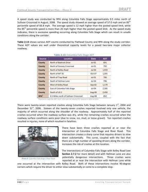
Table 2.13 shows various ADT counts conducted by <strong>Flathead</strong> <strong>County</strong> and RPA along the study corridor.<br />
These ADT values are well under theoretical capacity levels for a paved two‐lane major collector<br />
roadway.<br />
Table 2.13: Columbia Falls Stage ADT<br />
Source Location Date ADT<br />
<strong>County</strong> North of Badrock Drive Jul‐01 691<br />
<strong>County</strong> North of Gosney Crossroad Jul‐01 792<br />
<strong>County</strong> North of Kelley Road Jul‐04 1,919<br />
<strong>County</strong> North of MT 35 Oct‐07 1,591<br />
<strong>County</strong> North of Trap Road Jul‐01 706<br />
<strong>County</strong> South of Helman Lane Jul‐04 796<br />
<strong>County</strong> West of Kelley Road Sep‐02 1,170<br />
<strong>County</strong> East of Columbia Falls Stage Jul‐04 2,395<br />
<strong>County</strong> South of US 2 Aug‐06 2,450<br />
RPA 1 0.5 Miles north of Sullivan Crossroad Aug‐08 852<br />
1 Represents single day ADT count; value was not adjusted for seasonal or daily variation.<br />
There were twenty‐seven reported crashes along Columbia Falls Stage between January 1 st , 2004 and<br />
December 31 st , 2006. Sixteen of the twenty‐seven crashes reported involved only one vehicle, the<br />
majority of which occurred along the shoulder of the roadway. Approximately half of the reported<br />
crashes occurred when the roadway surface was dry, while the remaining crashes occurred when the<br />
roadway surface conditions were poor (due to snow, ice, mud, or loose gravel). Ten reported crashes<br />
resulted in injuries, none of which resulted in fatalities.<br />
There have been three crashes reported at or near the<br />
intersection of Columbia Falls Stage and River Road. This<br />
intersection creates a sharp curve that requires drivers to slow<br />
down substantially. This curve, coupled with the fact that<br />
there are a high number of speeding drivers along the corridor,<br />
increases the risk of crashes at this location.<br />
The intersections of Columbia Falls Stage with Kelley Road (see<br />
Section 2.7.2 for more detail) and with Hellman Lane are also<br />
potentially dangerous intersections. Three crashes were<br />
Photo 9: Columbia Falls Stage / River Road<br />
reported at or near the intersection with Hellman Lane while<br />
one occurred at the intersection with Kelley Road. Both of these intersections involve 90‐degree<br />
corners which require the driver to either slow substantially or come to a complete stop.<br />
2‐32 | P age Existing <strong>Transportation</strong> System