Flathead County Transportation Plan – Phase II
Flathead County Transportation Plan – Phase II
Flathead County Transportation Plan – Phase II

You also want an ePaper? Increase the reach of your titles
YUMPU automatically turns print PDFs into web optimized ePapers that Google loves.
<strong>Flathead</strong> <strong>County</strong> <strong>Transportation</strong> <strong>Plan</strong> <strong>–</strong> <strong>Phase</strong> <strong>II</strong><br />
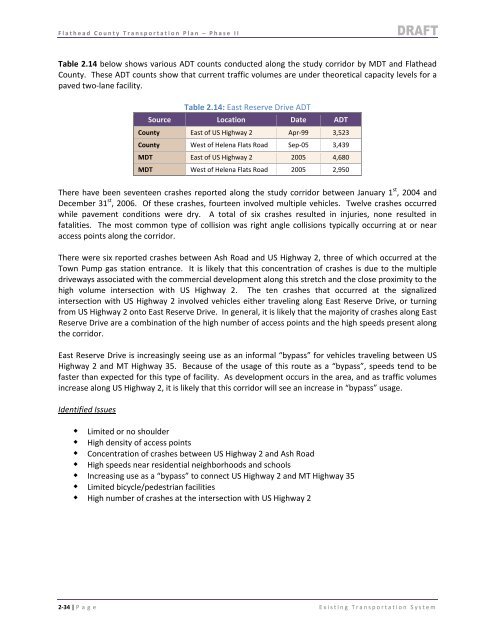
Table 2.14 below shows various ADT counts conducted along the study corridor by MDT and <strong>Flathead</strong><br />
<strong>County</strong>. These ADT counts show that current traffic volumes are under theoretical capacity levels for a<br />
paved two‐lane facility.<br />
Table 2.14: East Reserve Drive ADT<br />
Source Location Date ADT<br />
<strong>County</strong> East of US Highway 2 Apr‐99 3,523<br />
<strong>County</strong> West of Helena Flats Road Sep‐05 3,439<br />
MDT East of US Highway 2 2005 4,680<br />
MDT West of Helena Flats Road 2005 2,950<br />
There have been seventeen crashes reported along the study corridor between January 1 st , 2004 and<br />
December 31 st , 2006. Of these crashes, fourteen involved multiple vehicles. Twelve crashes occurred<br />
while pavement conditions were dry. A total of six crashes resulted in injuries, none resulted in<br />
fatalities. The most common type of collision was right angle collisions typically occurring at or near<br />
access points along the corridor.<br />
There were six reported crashes between Ash Road and US Highway 2, three of which occurred at the<br />
Town Pump gas station entrance. It is likely that this concentration of crashes is due to the multiple<br />
driveways associated with the commercial development along this stretch and the close proximity to the<br />
high volume intersection with US Highway 2. The ten crashes that occurred at the signalized<br />
intersection with US Highway 2 involved vehicles either traveling along East Reserve Drive, or turning<br />
from US Highway 2 onto East Reserve Drive. In general, it is likely that the majority of crashes along East<br />
Reserve Drive are a combination of the high number of access points and the high speeds present along<br />
the corridor.<br />
East Reserve Drive is increasingly seeing use as an informal “bypass” for vehicles traveling between US<br />
Highway 2 and MT Highway 35. Because of the usage of this route as a “bypass”, speeds tend to be<br />
faster than expected for this type of facility. As development occurs in the area, and as traffic volumes<br />
increase along US Highway 2, it is likely that this corridor will see an increase in “bypass” usage.<br />
Identified Issues<br />
Limited or no shoulder<br />
High density of access points<br />
Concentration of crashes between US Highway 2 and Ash Road<br />
High speeds near residential neighborhoods and schools<br />
Increasing use as a “bypass” to connect US Highway 2 and MT Highway 35<br />
Limited bicycle/pedestrian facilities<br />
High number of crashes at the intersection with US Highway 2<br />
2‐34 | P age Existing <strong>Transportation</strong> System