Flathead County Transportation Plan – Phase II
Flathead County Transportation Plan – Phase II
Flathead County Transportation Plan – Phase II

Create successful ePaper yourself
Turn your PDF publications into a flip-book with our unique Google optimized e-Paper software.
<strong>Flathead</strong> <strong>County</strong> <strong>Transportation</strong> <strong>Plan</strong> <strong>–</strong> <strong>Phase</strong> <strong>II</strong><br />
A speed study was conducted by RPA along Lower Valley Road east of Foys Bend Lane in August 2008.<br />
The speed study showed an average speed of 46.5 mph and an 85 th percentile speed of 55.7 mph. The<br />
speed study indicates that the average speed is slightly higher than the posted speed limit of 45 mph,<br />
while the 85 th percentile speed is more than 10 mph higher than the posted speed limit. The results of<br />
the speed study indicate that there is a potential speeding problem along Lower Valley Road.<br />
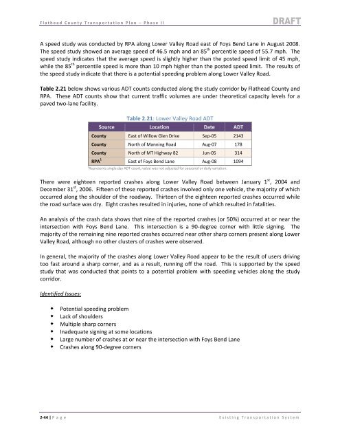
Table 2.21 below shows various ADT counts conducted along the study corridor by <strong>Flathead</strong> <strong>County</strong> and<br />
RPA. These ADT counts show that current traffic volumes are under theoretical capacity levels for a<br />
paved two‐lane facility.<br />
Table 2.21: Lower Valley Road ADT<br />
Source Location Date ADT<br />
<strong>County</strong> East of Willow Glen Drive Sep‐05 2143<br />
<strong>County</strong> North of Manning Road Aug‐07 178<br />
<strong>County</strong> North of MT Highway 82 Jun‐05 314<br />
RPA 1 East of Foys Bend Lane Aug‐08 1094<br />
1 Represents single day ADT count; value was not adjusted for seasonal or daily variation.<br />
There were eighteen reported crashes along Lower Valley Road between January 1 st , 2004 and<br />
December 31 st , 2006. Fifteen of these reported crashes involved only one vehicle, the majority of which<br />
occurred along the shoulder of the roadway. Thirteen of the eighteen reported crashes occurred while<br />
the road surface was dry. Eight crashes resulted in injuries, none of which resulted in fatalities.<br />
An analysis of the crash data shows that nine of the reported crashes (or 50%) occurred at or near the<br />
intersection with Foys Bend Lane. This intersection is a 90‐degree corner with little signing. The<br />
majority of the remaining nine reported crashes occurred near other sharp corners present along Lower<br />
Valley Road, although no other clusters of crashes were observed.<br />
In general, the majority of the crashes along Lower Valley Road appear to be the result of users driving<br />
too fast around a sharp corner, and as a result, running off the road. This is supported by the speed<br />
study that was conducted that points to a potential problem with speeding vehicles along the study<br />
corridor.<br />
Identified Issues:<br />
Potential speeding problem<br />
Lack of shoulders<br />
Multiple sharp corners<br />
Inadequate signing at some locations<br />
Large number of crashes at or near the intersection with Foys Bend Lane<br />
Crashes along 90‐degree corners<br />
2‐44 | P age Existing <strong>Transportation</strong> System