Flathead County Transportation Plan – Phase II
Flathead County Transportation Plan – Phase II
Flathead County Transportation Plan – Phase II

Create successful ePaper yourself
Turn your PDF publications into a flip-book with our unique Google optimized e-Paper software.
<strong>Flathead</strong> <strong>County</strong> <strong>Transportation</strong> <strong>Plan</strong> <strong>–</strong> <strong>Phase</strong> <strong>II</strong><br />
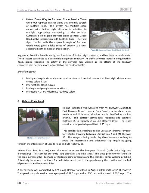
Peters Creek Way to Bachelor Grade Road <strong>–</strong> There<br />
were four reported crashes along this one‐mile stretch<br />
of Foothills Road. This stretch has multiple sharp<br />
curves with limited sight distance in addition to<br />
multiple approaches connecting to the corridor.<br />
Currently, a yield sign is provided along Bachelor Grade<br />
Road at the intersection with Foothills Road. The yield<br />
sign, coupled with the approach angle of Bachelor<br />
Grade Road, gives a false sense of priority to drivers<br />
accessing Foothills Road at this location.<br />
In general, Foothills Road is windy, has locations of limited sight distance, and has little to no shoulder.<br />
These factors contribute to a potentially dangerous roadway. As traffic volumes increase along Foothills<br />
Road, issues regarding the safety of the corridor may worsen as the effects of the roadway<br />
characteristics become more influential on the corridor traffic.<br />
Identified Issues:<br />
Multiple sharp horizontal curves and substandard vertical curves that limit sight distance and<br />
create safety issues<br />
Intersections along curves<br />
Inadequate signing in some locations<br />
Increasing ADT may decrease roadway safety<br />
6. Helena Flats Road<br />
Photo 13: Bachelor Grade Road / Foothills Road<br />
Helena Flats Road was evaluated from MT Highway 35 north to<br />
East Reserve Drive. Helena Flats Road is a two‐lane paved<br />
roadway with little to no shoulder and is classified as a minor<br />
arterial. This corridor serves local residents and connects<br />
Highway 35 to Highway 2 via East Reserve Drive. The study<br />
corridor has a posted speed limit of 35 mph.<br />
This corridor is increasingly seeing use as an informal “bypass”<br />
for vehicles traveling between US Highway 2 and MT Highway<br />
Photo 14: Helena Flats Road 35. This usage is being fueled by those travelers wishing to<br />
avoid the intersection and additional trip length by going<br />
through the intersection of LaSalle Road and MT Highway 35.<br />
Helena Flats Road is a major corridor used to access the Evergreen Schools (both junior high and<br />
elementary). This corridor currently lacks sidewalks and bike lanes. The close proximity to schools in<br />
the area increases the likelihood of students being present along the corridor, either walking or biking.<br />
Potentially hazardous conditions for pedestrians exist due to the speeds along the corridor and the lack<br />
of pedestrian and bicycle facilities.<br />
A speed study was conducted by RPA along Helena Flats Road in August 2008 north of US Highway 2.<br />
The speed study showed an average speed of 34.5 mph and an 85 th percentile speed of 39.2 mph. The<br />
2‐36 | P age Existing <strong>Transportation</strong> System