Burrard Inlet Environmental Indicators Report - the BIEAP and ...
Burrard Inlet Environmental Indicators Report - the BIEAP and ...
Burrard Inlet Environmental Indicators Report - the BIEAP and ...

Create successful ePaper yourself
Turn your PDF publications into a flip-book with our unique Google optimized e-Paper software.
<strong>Burrard</strong> <strong>Inlet</strong> <strong>Environmental</strong> <strong>Indicators</strong> <strong>Report</strong> February 2008<br />
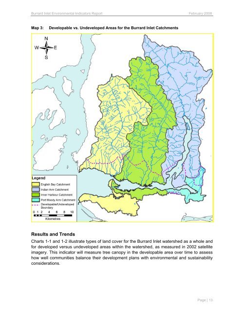
Map 3: Developable vs. Undeveloped Areas for <strong>the</strong> <strong>Burrard</strong> <strong>Inlet</strong> Catchments<br />
Results <strong>and</strong> Trends<br />
Charts 1-1 <strong>and</strong> 1-2 illustrate types of l<strong>and</strong> cover for <strong>the</strong> <strong>Burrard</strong> <strong>Inlet</strong> watershed as a whole <strong>and</strong><br />
for developed versus undeveloped areas within <strong>the</strong> watershed, as measured in 2002 satellite<br />
imagery. This indicator will measure tree canopy in <strong>the</strong> developable area over time to assess<br />
how well communities balance <strong>the</strong>ir development plans with environmental <strong>and</strong> sustainability<br />
considerations.<br />
Page | 13