Burrard Inlet Environmental Indicators Report - the BIEAP and ...
Burrard Inlet Environmental Indicators Report - the BIEAP and ...
Burrard Inlet Environmental Indicators Report - the BIEAP and ...

You also want an ePaper? Increase the reach of your titles
YUMPU automatically turns print PDFs into web optimized ePapers that Google loves.
<strong>Burrard</strong> <strong>Inlet</strong> <strong>Environmental</strong> <strong>Indicators</strong> <strong>Report</strong> February 2008<br />
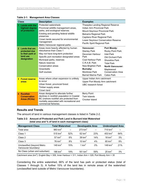
Table 2-1: Management Area Classes<br />
Class Description Examples<br />
1 L<strong>and</strong>s with <strong>the</strong><br />
highest degree<br />
of protection<br />
2 L<strong>and</strong>s that are<br />
protected due<br />
to <strong>the</strong>ir park or<br />
l<strong>and</strong> use<br />
designation<br />
3 Forest reserve<br />
areas<br />
4 Rockfish<br />
Conservation<br />
Areas (RCAs)<br />
Protected watersheds<br />
Provincial wildlife management areas,<br />
parks, <strong>and</strong> ecological reserves<br />
Existing <strong>and</strong> pending federal wildlife<br />
preserves<br />
Crown l<strong>and</strong>s secured for environmental<br />
management<br />
Metro Vancouver regional parks<br />
Areas more heavily affected by human<br />
disturbance than Class 1<br />
May not have long-term protection<br />
Specific port recreation designated areas<br />
Municipal parks, reserves<br />
Nature reserves<br />
Conservation areas<br />
Greenbelts<br />
Golf courses<br />
Areas where urban expansion is unlikely<br />
to occur<br />
Urban forest, provincial forest<br />
Timber supply areas<br />
Crown l<strong>and</strong><br />
Areas designed to alleviate fur<strong>the</strong>r<br />
declines in rockfish population in Coastal<br />
BC (inshore rockfish are protected from<br />
mortality associated with recreational <strong>and</strong><br />
commercial fisheries.<br />
Thwaytes L<strong>and</strong>ing Regional Reserve<br />
Indian Arm Provincial Park<br />
Mount Seymour Provincial Park<br />
Belcarra Regional Park<br />
Capilano River Regional Park<br />
Lower Seymour Conservation Reserve<br />
Pacific Spirit Regional Park<br />
Vancouver:<br />
Stanley Park<br />
Devonian Harbour<br />
Park<br />
Coal Harbour Park<br />
C.R.A.B. Park<br />
New Brighton Park<br />
Burnaby:<br />
Montrose Park<br />
Barnet Marine Park<br />
Port Moody:<br />
Rocky Point Park<br />
<strong>Inlet</strong> Park<br />
Old Orchard Park<br />
Shoreline Park<br />
Tidal Park<br />
North Vancouver:<br />
Maplewood<br />
Conservation Area<br />
Cates Park<br />
Upper Indian Arm catchment<br />
Upper Port Moody Arm catchment<br />
UBC research forest<br />
Berry Point<br />
Twin Isl<strong>and</strong>s<br />
Crocker Isl<strong>and</strong><br />
Results <strong>and</strong> Trends<br />
The amount of l<strong>and</strong> in various management classes is listed in Table 2-2.<br />
Table 2-2: Amount of Protected <strong>and</strong> Park L<strong>and</strong> in <strong>Burrard</strong> <strong>Inlet</strong> Watershed<br />
(total area <strong>and</strong> % of l<strong>and</strong> in each management class)<br />
Management Class Total Watershed Developable Area Undeveloped Area<br />
Total area 983 km 2<br />
– 273 km 2 – 710 km 2 –<br />
Class 1 515 km 2 52%<br />
62 km 2 23% 453 km 2 64%<br />
Class 2 57 km 2 6% 39 km 2 14% 18 km 2 3%<br />
Class 3 76 km 2 8% 10 km 2 4% 65 km 2 9%<br />
Unclassified (beyond Metro<br />
Vancouver boundary)<br />
149 km 2 15% 1 km 2 0% 149 km 2 21%<br />
No Class (urban <strong>and</strong> suburban) 186 km 2 19% 161 km 2 59% 25 km 2 3%<br />
Catchment area (km 2 ): English Bay = 308, Inner Harbour = 311, Indian Arm = 329, Port Moody Arm = 35<br />
Considering <strong>the</strong> entire watershed, 66% of <strong>the</strong> l<strong>and</strong> has park or protected status (total of<br />
Classes 1 through 3). A fur<strong>the</strong>r 15% of <strong>the</strong> l<strong>and</strong> lies in remote areas of <strong>the</strong> watershed<br />
(unclassified l<strong>and</strong> outside of Metro Vancouver boundaries).<br />
Page | 18