Burrard Inlet Environmental Indicators Report - the BIEAP and ...
Burrard Inlet Environmental Indicators Report - the BIEAP and ...
Burrard Inlet Environmental Indicators Report - the BIEAP and ...

You also want an ePaper? Increase the reach of your titles
YUMPU automatically turns print PDFs into web optimized ePapers that Google loves.
<strong>Burrard</strong> <strong>Inlet</strong> <strong>Environmental</strong> <strong>Indicators</strong> <strong>Report</strong> February 2008<br />
2. Parks <strong>and</strong> Protected Areas<br />
Why look at parks <strong>and</strong> protected areas?<br />
The parks <strong>and</strong> protected areas indicator helps<br />
describe <strong>the</strong> overall health status of <strong>the</strong> <strong>Burrard</strong> <strong>Inlet</strong><br />
ecosystem. These areas include provincial, regional<br />
<strong>and</strong> municipal parks, protected drinking water<br />
watersheds <strong>and</strong> areas such as <strong>the</strong> Lower Seymour<br />
Conservation Reserve. The parks <strong>and</strong> protected<br />
areas in <strong>Burrard</strong> <strong>Inlet</strong> are managed to conserve fish<br />
<strong>and</strong> wildlife habitat, <strong>and</strong> to preserve natural <strong>and</strong> built<br />
environments for public use.<br />
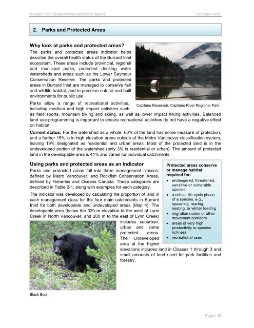
Parks allow a range of recreational activities,<br />
Capilano Reservoir, Capilano River Regional Park<br />
including medium <strong>and</strong> high impact activities such<br />
as field sports, mountain biking <strong>and</strong> skiing, as well as lower impact hiking activities. Balanced<br />
l<strong>and</strong> use programming is important to ensure recreational activities do not have a negative effect<br />
on habitat.<br />
Current status: For <strong>the</strong> watershed as a whole, 66% of <strong>the</strong> l<strong>and</strong> has some measure of protection,<br />
<strong>and</strong> a fur<strong>the</strong>r 15% is in high elevation areas outside of <strong>the</strong> Metro Vancouver classification system,<br />
leaving 19% designated as residential <strong>and</strong> urban areas. Most of <strong>the</strong> protected l<strong>and</strong> is in <strong>the</strong><br />
undeveloped portion of <strong>the</strong> watershed (only 3% is residential or urban). The amount of protected<br />
l<strong>and</strong> in <strong>the</strong> developable area is 41% <strong>and</strong> varies for individual catchments.<br />
Using parks <strong>and</strong> protected areas as an indicator<br />
Parks <strong>and</strong> protected areas fall into three management classes,<br />
defined by Metro Vancouver, <strong>and</strong> Rockfish Conservation Areas,<br />
defined by Fisheries <strong>and</strong> Oceans Canada. These categories are<br />
described in Table 2-1, along with examples for each category.<br />
The indicator was developed by calculating <strong>the</strong> proportion of l<strong>and</strong> in<br />
each management class for <strong>the</strong> four main catchments in <strong>Burrard</strong><br />
<strong>Inlet</strong> for both developable <strong>and</strong> undeveloped areas (Map 4). The<br />
developable area (below <strong>the</strong> 320 m elevation to <strong>the</strong> west of Lynn<br />
Creek in North Vancouver, <strong>and</strong> 200 m to <strong>the</strong> east of Lynn Creek)<br />
includes suburban,<br />
urban <strong>and</strong> some<br />
protected areas.<br />
The undeveloped<br />
area at <strong>the</strong> higher<br />
Black Bear<br />
Protected areas conserve<br />
or manage habitat<br />
required for:<br />
• endangered, threatened,<br />
sensitive or vulnerable<br />
species<br />
• a critical life-cycle phase<br />
of a species, e.g.,<br />
spawning, rearing,<br />
nesting, or winter feeding<br />
• migration routes or o<strong>the</strong>r<br />
movement corridors<br />
• areas of very high<br />
productivity or species<br />
richness<br />
• recreational uses<br />
elevations includes l<strong>and</strong> in Classes 1 through 3 <strong>and</strong><br />
small amounts of l<strong>and</strong> used for park facilities <strong>and</strong><br />
forestry.<br />
Page | 16