Annual Report 2009/2010 - JUWEL - Forschungszentrum Jülich
Annual Report 2009/2010 - JUWEL - Forschungszentrum Jülich
Annual Report 2009/2010 - JUWEL - Forschungszentrum Jülich

You also want an ePaper? Increase the reach of your titles
YUMPU automatically turns print PDFs into web optimized ePapers that Google loves.
parameters of the SAR system, such as the incidence angle [1,2]. That is why the<br />
investigation area proves to be challenging in two different aspects: First, the Olkiluoto Island<br />
is mainly covered by coniferous forest; second, the island’s surface is rather flat with<br />
maximum 18 meters height above sea level. However, as W0LF is expected to get into<br />
operation in 2020 as the first geological repository worldwide, possibilities and limits of SAR<br />
imagery processing are to be studied for this particular area.<br />
Site-specific Characteristics at Onkalo<br />
In 2004, Finland began underground construction of the Onkalo (Underground Rock<br />
Characterisation Facility), planned to be later licensed as a part of the Geological Repository<br />
on the Olkiluoto Island adjacent to the Olkiluoto Nuclear Power Plant in western Finland. The<br />
Olkiluoto area is flat; the highest point of the Olkiluoto Island is 18 m above present sea level.<br />
The access tunnel to the Onkalo underground facility is located at one of the local rocky hills<br />
(near the borehole KR8, Fig. 129 left) at the elevation of 9 to 10 meters above the present<br />
sea level.<br />
SAR detection<br />
exercise<br />
Onkalo<br />
GR<br />
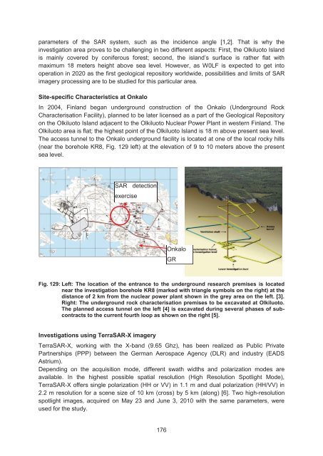
Fig. 129: Left: The location of the entrance to the underground research premises is located<br />
near the investigation borehole KR8 (marked with triangle symbols on the right) at the<br />
distance of 2 km from the nuclear power plant shown in the grey area on the left. [3].<br />
Right: The underground rock characterisation premises to be excavated at Olkiluoto.<br />
The planned access tunnel on the left [4] is excavated during several phases of subcontracts<br />
to the current fourth loop as shown on the right [5].<br />
Investigations using TerraSAR-X imagery<br />
TerraSAR-X, working with the X-band (9.65 Ghz), has been realized as Public Private<br />
Partnerships (PPP) between the German Aerospace Agency (DLR) and industry (EADS<br />
Astrium).<br />
Depending on the acquisition mode, different swath widths and polarization modes are<br />
available. In the highest possible spatial resolution (High Resolution Spotlight Mode),<br />
TerraSAR-X offers single polarization (HH or VV) in 1.1 m and dual polarization (HH/VV) in<br />
2.2 m resolution for a scene size of 10 km (cross) by 5 km (along) [6]. Two high-resolution<br />
spotlight images, acquired on May 23 and June 3, <strong>2010</strong> with the same parameters, were<br />
used for the study.<br />
176