Mineral Industries and Geology of Certain Areas - Vermont Agency ...
Mineral Industries and Geology of Certain Areas - Vermont Agency ...
Mineral Industries and Geology of Certain Areas - Vermont Agency ...
Create successful ePaper yourself
Turn your PDF publications into a flip-book with our unique Google optimized e-Paper software.
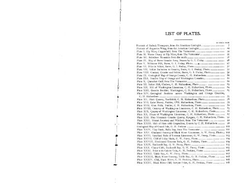
LIST OF PLATES.<br />
L<br />
TO FACE CAGE<br />
Fortrait <strong>of</strong> Zadock Thompson, from the American Geologist. . .................. 7<br />
Portrait <strong>of</strong> Augustus Wing, from the American Geologist...................... 2 2<br />
Plate I. Ely Mine, Copperfield, from The <strong>Vermont</strong>er......................... 34<br />
Plate II. Waste Dump at Ely Mine, from The <strong>Vermont</strong>er. .................... 35<br />
Plate III. Belvidere Mountain from the south -------------------------------- 36<br />
Plate IV. Map <strong>of</strong> Barre Granite Area, Drawn by G. I. Finlay ................. 46<br />
Plate V. Millstone Hill, Barre, G. I. Finlay, Photo. •. ...................... 47<br />
Plate VI. Dike in Schist, Barre, G. I. Finlay, Photo .......................... 50<br />
Plate VII. Schist Inclusion in Granite, Barre, G. I. Finlay, Photo ........... .. 51<br />
Plate VIII. Contact, Granite <strong>and</strong> Schist, Barre, G. I. Finlay, Photo ............ 52<br />
Plate IX. Geological Map <strong>of</strong> Orange County, C. H. Richardson................ 6o<br />
Plate IXA. Smaller Map <strong>of</strong> Orange <strong>and</strong> Washington Counties .................. 6i<br />
Plate X. Queechee Gulf, from The <strong>Vermont</strong>er................................ 62<br />
Plate XI. Schist Hill, Chelsea, C. H. Richardson, Photo ..................... 63<br />
Plate XII. Hill <strong>of</strong> Washington Limestone, C. H. Richardson, Photo........... 64<br />
Plate XHI. Granite Boulder, Washington, C. H. Richardson, Photo ----------- 6<br />
Plate XIV. Geological Sections across Washington <strong>and</strong> Orange Counties,<br />
C . H. Richardson ....................................................... 75<br />
Plate XV. Slate Quarry, Northfield, C. H. Richardson, Photo ................. 78<br />
Plate XVI. Lake Morey, Fairlee, C?H. Richardson, Photo.................... 79<br />
Plate XVII. Glen Falls, Fairlee, C. H. Richardson, Photo.................... So<br />
Plate XVIII. Outcrop <strong>of</strong> Washington Limestone, C. H. Richardson, Photo. .... 85<br />
Plate XIX. Quarry <strong>of</strong> Washington Limestone, C. H. Richardson, Photo........ 86<br />
Plate XX. Pieces <strong>of</strong> Washington Limestone, C. H. Richardson, Photo......... 87<br />
Plate XXI. Blue Mountain Granite Quarry, Ryegate, C. H. Richardson, Photo. 91<br />
Plate XXII. Mount Ascutney <strong>and</strong> Windsor, from The <strong>Vermont</strong>er.......... 92<br />
Plate XXIII. Slab <strong>of</strong> Slate with Graptolites, Drawn by C. H. Richardson ...... 96<br />
Geological Map <strong>of</strong> Gr<strong>and</strong> Isle, G. H. Perkins ................................ 102<br />
Plate XXIV. Clay Bank, Balls Bay, from The <strong>Vermont</strong>er. -------------------- 111<br />
Plate XXV. Glaciated Outcrop <strong>of</strong> Black River Limestone, G. W. Perry, Photo.. 112<br />
Plate XXVI. Synclinal Beds <strong>of</strong> Trenton Limestone, G. W. Perry, Photo ........ 513<br />
Plate XXVII. Cliff <strong>of</strong> Utica Shale, G. W. Perry, Photo....................... 114<br />
Plate XXVIII. Horizontal Trenton Beds, G. H. Perkins, Photo...............<br />
Plate XXIX. Rockwell Bay, G. W. Perry, Photo ............................. '15<br />
Plate XXX. Chary Cliffs, Rockwell Bay, G. \V. Perry, Photo .................<br />
Plate XXXI. Dike with Calcite Vein, G. H. Perkins, Photo .................. a 16<br />
Plate XXXII. Table Bay, G. W. Perry, Photo............................... 117<br />
Plate XXXIII, Black River Outcrop, Tahie Bay, G. H. Perkins, Photo ........ 117<br />
Plate XXXIV. Cliff, Black River, G. Fl. Perkins, Photo ...................... itS<br />
Plate XXXV. Black River C1i6 Sawyer Point, G. H. Perkins, Photo .......... 118


