Mineral Industries and Geology of Certain Areas - Vermont Agency ...
Mineral Industries and Geology of Certain Areas - Vermont Agency ...
Mineral Industries and Geology of Certain Areas - Vermont Agency ...

You also want an ePaper? Increase the reach of your titles
YUMPU automatically turns print PDFs into web optimized ePapers that Google loves.
REPORT OF THE VERMONT STATE GEOLOGIST.<br />
C)<br />
C)<br />
0<br />
C)<br />
U<br />
within one mile <strong>of</strong> Bradford Village. Here the slate terminates<br />
abruptly <strong>and</strong> the Huronian rocks take its place. It does not clip<br />
under the Washington limestone, for that rock lies io miles to<br />
the west; nor under the Bradford schist, for the strike <strong>of</strong> the<br />
Bradford schist is parallel with the slate, viz, north <strong>and</strong> south.<br />
The Huronian rocks are laid bare to the west until they touch<br />
directly the Bradford schist. It may be that here is the beginning<br />
<strong>of</strong> the great fault that lies farther up Waits River valley.<br />
Excluding the fault theory, the slate must suddenly increase<br />
in thickness, <strong>and</strong> disintegration <strong>and</strong> erosion must have obliterated<br />
the last relic <strong>of</strong> the slate.<br />
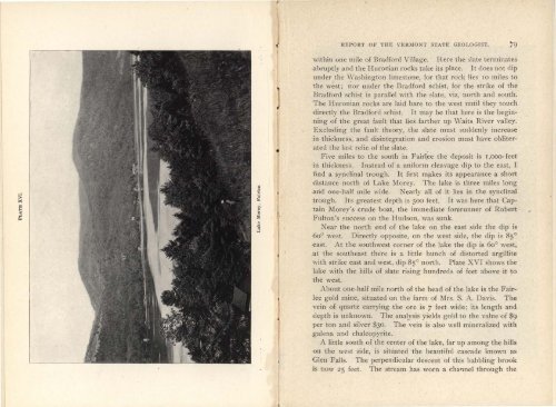
Five miles to the south in Fairlee the deposit is 1,000 feet<br />
in thickness. Instead <strong>of</strong> a uniform cleavage dip to the east, I<br />
find a svnclinal trough. It first makes its appearance a short<br />
distance north <strong>of</strong> Lake Morey. The lake is three miles long<br />
arid one-half mile wide. Nearly all <strong>of</strong> it lies in the synclinal<br />
trough. Its greatest depth is 500 feet. It was here that Captain<br />
Morey's crude boat, the immediate forerunner <strong>of</strong> Robert<br />
Fulton's success on the Hudson, was sunk.<br />
Near the north end <strong>of</strong> the lake on the east side the dip is<br />
600 west. Directly opposite, on the west side, the dip is 85 °<br />
east. At the southwest corner <strong>of</strong> the lake the dip is 6o° west,<br />
at the southeast there is a little bunch <strong>of</strong> distorted argillite<br />
with strike east <strong>and</strong> west, clip 8 ° north. Plate XVI shows the<br />
lake with the hills <strong>of</strong> slate rising hundreds <strong>of</strong> feet above it to<br />
the west.<br />
About one-half mile north <strong>of</strong> the head <strong>of</strong> the lake is the Fairlee<br />
gold mine, situated on the farm <strong>of</strong> Mrs. S. A. Davis. The<br />
vein <strong>of</strong> quartz carrying the ore is 7 feet wide; its length <strong>and</strong><br />
depth is unknown. The analysis yields gold to the valtie <strong>of</strong> $9<br />
per ton <strong>and</strong> silver $30. The vein is also well mineralized with<br />
galena <strong>and</strong> chalcopyrite.<br />
A little south <strong>of</strong> the center <strong>of</strong> the lake, far up among the hills<br />
on the west side, is situated the beautiful cascade known as<br />
Glen Falls. The perpendicular descent <strong>of</strong> this babbling brook<br />
is now 25 feet. The stream has worn a channel through the