Mineral Industries and Geology of Certain Areas - Vermont Agency ...
Mineral Industries and Geology of Certain Areas - Vermont Agency ...
Mineral Industries and Geology of Certain Areas - Vermont Agency ...

You also want an ePaper? Increase the reach of your titles
YUMPU automatically turns print PDFs into web optimized ePapers that Google loves.
4<br />
REPORT OF THE VERMONT STATE GEOLOGIST.<br />
440 25' <strong>and</strong> embraces the larger parts <strong>of</strong> Orange, Caledonia,<br />
Washington <strong>and</strong> Windsor counties. It also covers an area <strong>of</strong><br />
more than 3,000 square miles <strong>of</strong> stratified, igneous <strong>and</strong> metamorphic<br />
rocks <strong>of</strong> Huronian <strong>and</strong> Silurian age.<br />
The stratigraphical map (Plate XIV) represents five protracted<br />
sections, extending from the Connecticut River on the<br />
east through the Huronian <strong>and</strong> Lower Silurian terranes to the<br />
Huronian schists on the west. Their original trend is to the<br />
iorthwest, nearly at right angles with the average strike <strong>of</strong> the<br />
Washington limestone, north 200 east.<br />
No attempt is made at plottmg the clii) <strong>of</strong> the planes <strong>of</strong> bedding<br />
save as they conform with cleavage, for the former is<br />
subsequently illustrated with half-tone cuts from sveral localities<br />
where there is a marked non-conformity <strong>of</strong> bedding <strong>and</strong><br />
cleavage planes.<br />
TOPOGRAPHY.<br />
The topography <strong>of</strong> the area is unity in variety. ltaly is a<br />
l<strong>and</strong> <strong>of</strong> rarer sunsets <strong>and</strong> deeper sky; Switzerl<strong>and</strong> is a region<br />
<strong>of</strong> more towering sublimity <strong>and</strong> unapproachable gr<strong>and</strong>eur. Yet<br />
these do not surpass the majestic hills <strong>and</strong> beautiful valleys <strong>of</strong><br />
eastern <strong>Vermont</strong> in the exquisite genius <strong>of</strong> creative art. They<br />
blend all that is beautiful <strong>and</strong> attractive with nothing to terrify<br />
the eye. It is a Silurian tablel<strong>and</strong> sculptured by Tertiary<br />
denuclations.<br />
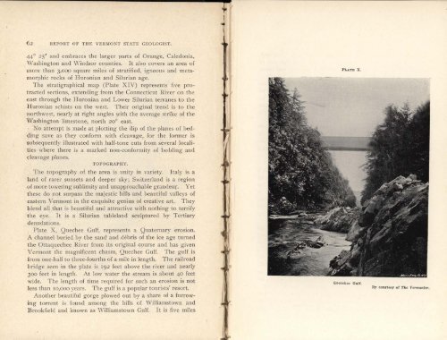
Plate X, Ouechee Gulf, represents a Quaternary erosion.<br />
A channel buried by the s<strong>and</strong> <strong>and</strong> debris <strong>of</strong> the ice age turned<br />
the Ottaquechee River from its original course <strong>and</strong> has given<br />
<strong>Vermont</strong> the magnificent chasm, Quechee Gulf. The gulf is<br />
from one-half to three-fourths <strong>of</strong> a mile in length. The railroad<br />
bridge seen in the plate is 192 feet above the river <strong>and</strong> nearly<br />
oo feet in length. At low water the stream is about 40 feet<br />
wide. The length <strong>of</strong> time required for such an erosion is not<br />
less than 10,000 years. The gulf is a popular tourists' resort.<br />
Another beautiful gorge plowed out by a share <strong>of</strong> a furrow -<br />
ing torrent is found among the hills <strong>of</strong> Williamstown <strong>and</strong><br />
Brookfield <strong>and</strong> known as Williamstown Gulf. It is five miles<br />
PLATE X.<br />
I'- Gull<br />
By courtesy <strong>of</strong> The <strong>Vermont</strong>er.