Mineral Industries and Geology of Certain Areas - Vermont Agency ...
Mineral Industries and Geology of Certain Areas - Vermont Agency ...
Mineral Industries and Geology of Certain Areas - Vermont Agency ...

You also want an ePaper? Increase the reach of your titles
YUMPU automatically turns print PDFs into web optimized ePapers that Google loves.
--__ -<br />
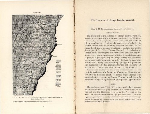
PLATE IXA.<br />
The Terranes <strong>of</strong> Orange County, <strong>Vermont</strong>.<br />
DR. C. H. RICHARDSON, DARTMOUTH COLLEGE.<br />
Geological Map <strong>of</strong> Orange county, with Part, <strong>of</strong> Washington <strong>and</strong> Windsor Counties, Vt.<br />
Scale, 10 mIles .=1 inch.<br />
N0TE.—The black area along the Connecticut sliver is Modified Drift.<br />
INTRODUCTION.<br />
The treatment <strong>of</strong> the terranes <strong>of</strong> Orange county, <strong>Vermont</strong>,<br />
records a most searching <strong>and</strong> ultimate analysis <strong>of</strong> the Washington<br />
marble, which singularly carries more than one-fourth <strong>of</strong><br />
all known elements. It shows the percentage <strong>of</strong> solubility in<br />
several surface samples <strong>of</strong> widely different localities. It discusses<br />
the olivine <strong>of</strong> Corinth, the source <strong>of</strong> the famous Thetford<br />
limburgite <strong>of</strong> Dr. Oliver Payson Hubbard. It embodies an<br />
analysis <strong>of</strong> the arsenopyrite <strong>of</strong> Braintree <strong>and</strong> the scales <strong>of</strong> phyllite<br />
set transverse to the planes <strong>of</strong> foliation in the shaly terranes.<br />
It presents a geological map <strong>of</strong> Orange county <strong>and</strong> protracted<br />
sections across the same, with legends. It gives chapters upon<br />
bibliography, topography, chemistry, geology <strong>and</strong> paleontology,<br />
accompanied by two maps <strong>and</strong> thirteen half-tone cuts. It<br />
divides the "Calciferous Mica Schist" <strong>of</strong> Pr<strong>of</strong>essor C. H.<br />
Hitchcock into a calcareous <strong>and</strong> a non-calcareous member; <strong>and</strong><br />
carefully designates the former as Washington limestone <strong>and</strong><br />
the latter as Bradford schist. It locates these terranes from<br />
1 : paleontological evidence as Lower Trenton, which formerly<br />
have been recognized by American geologists as Upper Silurian.<br />
3 MAPS.<br />
The geological map (Plate IX*) represents the distribution <strong>of</strong><br />
heterogeneous terranes lying between the Connecticut River on<br />
the east <strong>and</strong> the Huronian rocks <strong>of</strong> central <strong>Vermont</strong> on the<br />
west. It extends from latitude 430 30' northward to latitude<br />
By an unfortunate error the Granite areas are shown in the same manner as are the<br />
modified drift, but the only drift area is that which borders the Connecticut river, all<br />
the remaining black spaces are granite.