Mineral Industries and Geology of Certain Areas - Vermont Agency ...
Mineral Industries and Geology of Certain Areas - Vermont Agency ...
Mineral Industries and Geology of Certain Areas - Vermont Agency ...

You also want an ePaper? Increase the reach of your titles
YUMPU automatically turns print PDFs into web optimized ePapers that Google loves.
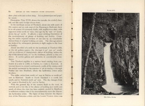
80 REPORT OF THE VERMONT STATE GEOLOGIST.<br />
slate 4 feet wide <strong>and</strong> 10 feet deep. It is a picturesque <strong>and</strong> popular<br />
resort.<br />
Illustration, Plate XVII, shows the cascade, the eroded channel,<br />
<strong>and</strong> the rustic bridge above them.<br />
In the northeast corner <strong>of</strong> Thetford, about one mile south <strong>of</strong><br />
Ely station <strong>and</strong> 50 rods west <strong>of</strong> the Passumpsic Railroad, there<br />
is an old quarry <strong>of</strong> extremely fissile, s<strong>of</strong>t, argillaceous slate, with<br />
apparent strike north io° east, cleavage dip 85 ° east 10° south,<br />
strata (lip 45° north. It affords a most striking illustration <strong>of</strong><br />
the nonconformity <strong>of</strong> planes <strong>of</strong> bedding <strong>and</strong> fissility. Crossing<br />
the entire exposed surface <strong>of</strong> ioo feet by 25 remarkably<br />
distinct lines <strong>of</strong> original bedding are seen. The cleavage planes<br />
are induced by subsequent pressure at right angles to the lines<br />
<strong>of</strong> fissility.<br />
About one-third <strong>of</strong> a mile to the northeast <strong>of</strong> Thetford Hill,<br />
at the old galena quarry, the cleavage is 40° east 30° south<br />
with no evidence <strong>of</strong> characteristic planes <strong>of</strong> bedding, unless the<br />
dip <strong>of</strong> the mineral vein, 21 ° to the southeast, affords us that evidence.<br />
It carries galena <strong>and</strong> sphalerite in considerable abundance.<br />
This Thetford argillite is a narrow b<strong>and</strong> varying from onefourth<br />
<strong>of</strong> a mile in width, in Fairlee, to i mile in Norwich. It<br />
was not known to extend continuously north <strong>of</strong> Ely station until<br />
the author succeeded in the summer <strong>of</strong> '96 in tracing it through<br />
Fairlee <strong>and</strong> into Bradford, where the hydromica schist takes<br />
its place.<br />
The strike varies from north 10° east in Fairlee to north 50 °<br />
east in Hartford. South <strong>of</strong> North Hartl<strong>and</strong> it is north <strong>and</strong><br />
south, <strong>and</strong> in Norwich north 45° east. The dip changes from<br />
6o° west in Hartford to 85 ° east in Fairlee.<br />
With the general dip <strong>of</strong> the eastern flank to the west, or<br />
vertical, <strong>and</strong> a low dip <strong>of</strong> the planes <strong>of</strong> bedding just north <strong>and</strong><br />
south <strong>of</strong> where the slate has been entirely eroded in Bradford,<br />
is sufficient evidence that it lies unconformably upoii the Huronian<br />
hydromica schist. The lapse <strong>of</strong> time between the deposition<br />
<strong>of</strong> the Huronian schists <strong>and</strong> the Lower Trenton slates was<br />
Ll<br />
I<br />
PLATE XVTT.<br />
Glen Falls, Fairlee.