Adaptive collaborative management of community forests in Asia ...
Adaptive collaborative management of community forests in Asia ...
Adaptive collaborative management of community forests in Asia ...

Create successful ePaper yourself
Turn your PDF publications into a flip-book with our unique Google optimized e-Paper software.
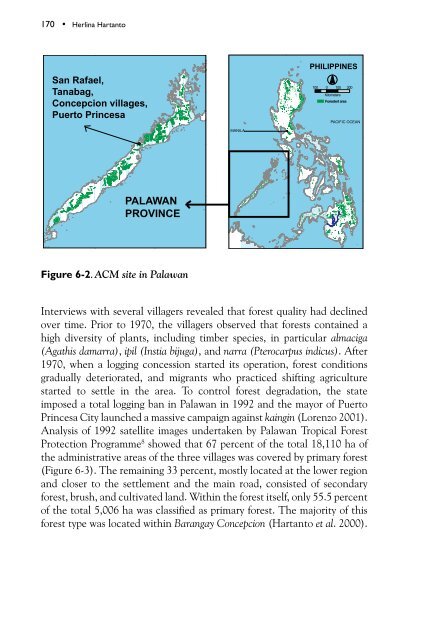
170 • Herl<strong>in</strong>a Hartanto<br />
San Rafael,<br />
Tanabag,<br />
Concepcion villages,<br />
Puerto Pr<strong>in</strong>cesa<br />
Philipp<strong>in</strong>es<br />
PACIFIC OCEAN<br />
MANILA<br />
PALAWAN<br />
PROVINCE<br />
Figure 6-2. ACM site <strong>in</strong> Palawan<br />
Interviews with several villagers revealed that forest quality had decl<strong>in</strong>ed<br />
over time. Prior to 1970, the villagers observed that <strong>forests</strong> conta<strong>in</strong>ed a<br />
high diversity <strong>of</strong> plants, <strong>in</strong>clud<strong>in</strong>g timber species, <strong>in</strong> particular almaciga<br />
(Agathis damarra), ipil (Instia bijuga), and narra (Pterocarpus <strong>in</strong>dicus). After<br />
1970, when a logg<strong>in</strong>g concession started its operation, forest conditions<br />
gradually deteriorated, and migrants who practiced shift<strong>in</strong>g agriculture<br />
started to settle <strong>in</strong> the area. To control forest degradation, the state<br />
imposed a total logg<strong>in</strong>g ban <strong>in</strong> Palawan <strong>in</strong> 1992 and the mayor <strong>of</strong> Puerto<br />
Pr<strong>in</strong>cesa City launched a massive campaign aga<strong>in</strong>st ka<strong>in</strong>g<strong>in</strong> (Lorenzo 2001).<br />
Analysis <strong>of</strong> 1992 satellite images undertaken by Palawan Tropical Forest<br />
Protection Programme 8 showed that 67 percent <strong>of</strong> the total 18,110 ha <strong>of</strong><br />
the adm<strong>in</strong>istrative areas <strong>of</strong> the three villages was covered by primary forest<br />
(Figure 6-3). The rema<strong>in</strong><strong>in</strong>g 33 percent, mostly located at the lower region<br />
and closer to the settlement and the ma<strong>in</strong> road, consisted <strong>of</strong> secondary<br />
forest, brush, and cultivated land. With<strong>in</strong> the forest itself, only 55.5 percent<br />
<strong>of</strong> the total 5,006 ha was classified as primary forest. The majority <strong>of</strong> this<br />
forest type was located with<strong>in</strong> Barangay Concepcion (Hartanto et al. 2000).