sustainable use of biological diversity.pdf - India Environment Portal
sustainable use of biological diversity.pdf - India Environment Portal
sustainable use of biological diversity.pdf - India Environment Portal

Create successful ePaper yourself
Turn your PDF publications into a flip-book with our unique Google optimized e-Paper software.
The communal forest, wetland, rangeland and agricultural landscape mosaics <strong>of</strong> the Lower Tana, Kenya: A socio-ecological entity in peril<br />
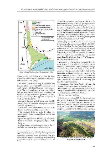
figure 2. Map <strong>of</strong> the lower tana floodplains and delta<br />
resource, fisheries productivity, etc. Thus the flooding<br />
regime is key to the ecosystem services they provide<br />
for human well-being. 1<br />
The riverine forests cover only an estimated 2600<br />
hectares (Mbora and Meikle 2004b) and are <strong>of</strong> a very<br />
patchy nature with about 70 separate entities recognized.<br />
The forest patches range from 1 to 500 hectares<br />
but most are less than 50 hectares and they are<br />
separated by agricultural land, grassland and bushland.<br />
Five main vegetation types are recognized in<br />
the forest (Hughes 1990):<br />
• evergreen forest on sandy levees, characterised by<br />
Ficus sycomorus, Sorindeia madagascariensis and<br />
Sterculia appendiculata<br />
• evergreen Acacia forest at the outer limit <strong>of</strong> the<br />
forest belt, characterized by Acacia eliator<br />
• clay evergreen forest on moist floodplain soils<br />
dominated by Diospyros mespiliformis and Garcinia<br />
livingstonei<br />
• point-bar vegetation on the low-lying sandy inner<br />
banks <strong>of</strong> meanders developing into Populus ilicifolia<br />
forest<br />
• oxbow pioneer vegetation dominated by Terminalia<br />
brevipes and/or Spirostachus venenifera.<br />
Over 300 plant species have been recorded from the<br />
forests <strong>of</strong> which about 60 are tree species and two <strong>of</strong><br />
those are considered globally endangered (Cynometra<br />
lukei and Megalochlamys tanaensis). Over 20 per<br />
cent <strong>of</strong> the plant species are <strong>of</strong> conservation concern<br />
and six are considered globally vulnerable: Oxystigma<br />
msoo, Angylocalyx braunii, Dalbergia vaciniifolia,<br />
Chytranthus obliquinervis, Diospyros greenwayi and<br />
Pavetta linearifolia (Luke et al. 2005).<br />
The flagship conservation species in the area are<br />
two endangered primates (Jong and Butynski, 2009):<br />
the Tana River Red Colobus Procolobus rufomitratus<br />
rufomitratus and the Tana Mangabey Cercocebus<br />
galeritus (estimated population size <strong>of</strong> about 1200<br />
individuals). In 1976 an area <strong>of</strong> about 17,000 hectares<br />
<strong>of</strong> floodplain and adjacent terrace was gazetted<br />
as the Tana River Primate Reserve (TRPR), primarily<br />
to conserve these species.<br />
Administratively the study area is situated in the<br />
Coast Province but a substantial proportion <strong>of</strong> the<br />
rangelands with which it strongly interacts through<br />
mobile livestock and pastoralists is in the Northeastern<br />
province, in particular the Ijara District. The<br />
floodplains and forests <strong>of</strong> the study area are in the<br />
former Tana River District (38,782 square kilometers,<br />
232,488 inhabitants, average 6 inhabitants per<br />
square kilometer). This district was recently split<br />
into three separate districts:<br />
• the southern Tana Delta District (<strong>of</strong> which the<br />
Garsen Division covers part <strong>of</strong> the study area)<br />
• the central Tana River District (with most <strong>of</strong> the<br />
study area in the Wenje Division and a lot <strong>of</strong> the<br />
western rangelands in Galole Division)<br />
• the northern Bura District.<br />
Statistics are not yet available for the separate new<br />
districts so reference will be made continuously to<br />
the “Greater Tana River District”, comprising the<br />
three new districts. The southeastern part <strong>of</strong> the<br />
study area is adjacent to the rangelands <strong>of</strong> the northern<br />
part <strong>of</strong> Lamu District. All these areas are highly<br />
© C. Jackson<br />
1<br />
Based on the findings <strong>of</strong> the Millennium Ecosystem Assessment<br />
(2005), human well-being can be defined as the freedom <strong>of</strong> choice<br />
and action to achieve basic material for a good life, health, good<br />
social relations and security. Well-being is at the opposite end <strong>of</strong><br />
a continuum from poverty, a pronounced deprivation in wellbeing.<br />
lower tana landscape with oxbow lake, forest, floodplain<br />
grassland and river branches<br />
55