sustainable use of biological diversity.pdf - India Environment Portal
sustainable use of biological diversity.pdf - India Environment Portal
sustainable use of biological diversity.pdf - India Environment Portal

Create successful ePaper yourself
Turn your PDF publications into a flip-book with our unique Google optimized e-Paper software.
The communal forest, wetland, rangeland and agricultural landscape mosaics <strong>of</strong> the Lower Tana, Kenya: A socio-ecological entity in peril<br />
virtually disappeared during the late 1980s, beca<strong>use</strong><br />
<strong>of</strong> intensive poaching, but various ungulate species<br />
are still quite abundant in the area and human<br />
wildlife conflict, especially with buffalo, is a major<br />
complaint <strong>of</strong> the local communities when interacting<br />
with the Kenya Wildlife Service.<br />
In summary, since time immemorial the area has<br />
provided a wide range <strong>of</strong> mostly flood-dependent<br />
ecosystem services to the different <strong>use</strong>rs (table 1).<br />
This dynamic equilibrium and the human wellbeing<br />
dependent on the services are increasingly<br />
threatened through a large number <strong>of</strong> indirect and<br />
direct drivers <strong>of</strong> change (figure 5).<br />
6. Threats to ecosystem functioning and human<br />
well-being<br />
6.1 Indirect drivers <strong>of</strong> change<br />
Rural Kenya continues to have a highly dynamic<br />
demography with on a total fertility <strong>of</strong> on average<br />
5.2 children/woman (in comparison to 3.1 in urban<br />
areas) and, though still declining the predicted transition<br />
to lower fertility seems to be slowing (Opiyo<br />
2003). In 1966 the “Greater Tana River District” had<br />
42,700 inhabitants but this figure may be less reliable<br />
than later surveys and would therefore overestimate<br />
growth rates. In 1979 the population was 92,000,<br />
growing to 181,000 in 1999 and 232,500 in 2005,<br />
or an annual population growth rate <strong>of</strong> 3.6 per cent<br />
(to be compared with the national average <strong>of</strong> 2.6 per<br />
cent).<br />
6.2 Direct drivers <strong>of</strong> change<br />
Land <strong>use</strong> change, i.e. the conversion <strong>of</strong> communal<br />
land to either nature protection (e.g. the Tana River<br />
Primate Reserve) or large-scale irrigation (e.g. the<br />
Tana Delta Irrigation Project) in combination with<br />
the demographics but without great advances in<br />
technology or economic processes, e.g. poor marfigure<br />
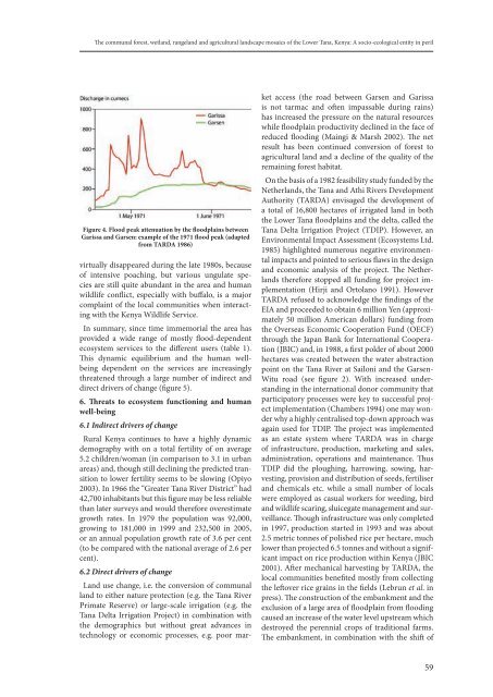
4. flood peak attenuation by the floodplains between<br />
garissa and garsen: example <strong>of</strong> the 1971 flood peak (adapted<br />
from tarda 1986)<br />
ket access (the road between Garsen and Garissa<br />
is not tarmac and <strong>of</strong>ten impassable during rains)<br />
has increased the pressure on the natural resources<br />
while floodplain productivity declined in the face <strong>of</strong><br />
reduced flooding (Maingi & Marsh 2002). The net<br />
result has been continued conversion <strong>of</strong> forest to<br />
agricultural land and a decline <strong>of</strong> the quality <strong>of</strong> the<br />
remaining forest habitat.<br />
On the basis <strong>of</strong> a 1982 feasibility study funded by the<br />
Netherlands, the Tana and Athi Rivers Development<br />
Authority (TARDA) envisaged the development <strong>of</strong><br />
a total <strong>of</strong> 16,800 hectares <strong>of</strong> irrigated land in both<br />
the Lower Tana floodplains and the delta, called the<br />
Tana Delta Irrigation Project (TDIP). However, an<br />
<strong>Environment</strong>al Impact Assessment (Ecosystems Ltd.<br />
1985) highlighted numerous negative environmental<br />
impacts and pointed to serious flaws in the design<br />
and economic analysis <strong>of</strong> the project. The Netherlands<br />
therefore stopped all funding for project implementation<br />
(Hirji and Ortolano 1991). However<br />
TARDA ref<strong>use</strong>d to acknowledge the findings <strong>of</strong> the<br />
EIA and proceeded to obtain 6 million Yen (approximately<br />
50 million American dollars) funding from<br />
the Overseas Economic Cooperation Fund (OECF)<br />
through the Japan Bank for International Cooperation<br />
(JBIC) and, in 1988, a first polder <strong>of</strong> about 2000<br />
hectares was created between the water abstraction<br />
point on the Tana River at Sailoni and the Garsen-<br />
Witu road (see figure 2). With increased understanding<br />
in the international donor community that<br />
participatory processes were key to successful project<br />
implementation (Chambers 1994) one may wonder<br />
why a highly centralised top-down approach was<br />
again <strong>use</strong>d for TDIP. The project was implemented<br />
as an estate system where TARDA was in charge<br />
<strong>of</strong> infrastructure, production, marketing and sales,<br />
administration, operations and maintenance. Thus<br />
TDIP did the ploughing, harrowing, sowing, harvesting,<br />
provision and distribution <strong>of</strong> seeds, fertiliser<br />
and chemicals etc. while a small number <strong>of</strong> locals<br />
were employed as casual workers for weeding, bird<br />
and wildlife scaring, sluicegate management and surveillance.<br />
Though infrastructure was only completed<br />
in 1997, production started in 1993 and was about<br />
2.5 metric tonnes <strong>of</strong> polished rice per hectare, much<br />
lower than projected 6.5 tonnes and without a significant<br />
impact on rice production within Kenya (JBIC<br />
2001). After mechanical harvesting by TARDA, the<br />
local communities benefited mostly from collecting<br />
the leftover rice grains in the fields (Lebrun et al. in<br />
press). The construction <strong>of</strong> the embankment and the<br />
exclusion <strong>of</strong> a large area <strong>of</strong> floodplain from flooding<br />
ca<strong>use</strong>d an increase <strong>of</strong> the water level upstream which<br />
destroyed the perennial crops <strong>of</strong> traditional farms.<br />
The embankment, in combination with the shift <strong>of</strong><br />
59