

Ground-Water Hydrology of the Upper Klamath Basin, Oregon and ...
Ground-Water Hydrology of the Upper Klamath Basin, Oregon and ...
Ground-Water Hydrology of the Upper Klamath Basin, Oregon and ...

Create successful ePaper yourself
Turn your PDF publications into a flip-book with our unique Google optimized e-Paper software.
12 <strong>Ground</strong>-<strong>Water</strong> <strong>Hydrology</strong> <strong>of</strong> <strong>the</strong> <strong>Upper</strong> <strong>Klamath</strong> <strong>Basin</strong>, <strong>Oregon</strong> <strong>and</strong> California<br />
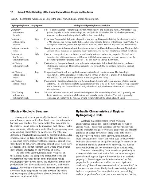
Table 1.<br />
Generalized hydrogeologic units in <strong>the</strong> upper <strong>Klamath</strong> <strong>Basin</strong>, <strong>Oregon</strong> <strong>and</strong> California.<br />
Hydrogeologic unit Map symbol Lithologic <strong>and</strong> hydrologic characteristics<br />
Quaternary<br />
sedimentary<br />
deposits<br />
Quaternary<br />
volcaniclastic<br />
deposits<br />
Quaternary volcanic<br />
rocks<br />
Quaternary to<br />
late Tertiary<br />
sedimentary rocks<br />
Late Tertiary<br />
sedimentary rocks<br />
Late Tertiary<br />
volcaniclastic<br />
rocks<br />
Late Tertiary<br />
volcanic rocks<br />
Older Tertiary<br />
volcanic <strong>and</strong><br />
sedimentary rocks<br />
Qs<br />
Qvp<br />
Qv<br />
QTs<br />
Ts<br />
Tvpt<br />
Tv<br />
Tovs<br />
Fine- to coarse-grained sediments deposited in stream valleys <strong>and</strong> major lake basins. Permeable coarsegrained<br />
deposits occur in stream valleys <strong>and</strong> locally in <strong>the</strong> lake basins. The lake basin deposits are,<br />
however, predominantly fine grained <strong>and</strong> have low permeability.<br />
Pyroclastic flows <strong>and</strong> air fall material (pumice, ash, <strong>and</strong> lapilli) deposited during <strong>the</strong> climactic eruption<br />
<strong>of</strong> Mt. Mazama that formed Crater Lake, <strong>and</strong> debris avalanche deposits <strong>of</strong> <strong>the</strong> Shasta River Valley. Air<br />
fall deposits are highly permeable. Pyroclastic flows <strong>and</strong> debris deposits may have low permeability.<br />
Basaltic <strong>and</strong> <strong>and</strong>esitic lavas <strong>and</strong> vent deposits occurring in <strong>the</strong> Cascade Range <strong>and</strong> around Medicine Lake<br />
Volcano. These materials are generally highly permeable, but may not be saturated at high elevations.<br />
Fine- to coarse-grained unconsolidated to moderately indurated sedimentary deposits. The hydraulic<br />
characteristics <strong>of</strong> this unit are not well known but lithologic descriptions on maps suggest it may be<br />
moderately permeable at some locations. This unit has very limited distribution.<br />
Predominately fine-grained continental sedimentary deposits including bedded diatomite, mudstone,<br />
siltstone, <strong>and</strong> s<strong>and</strong>stone. This unit has generally low permeability but contains permeable strata at<br />
some locations.<br />
Palagonitized basaltic ash <strong>and</strong> lapilli deposits associated with eruptive centers. The hydrologic<br />
characteristics <strong>of</strong> this unit are not well known, but springs are known to emerge from basal contact<br />
with unit Ts. This unit is most prominent in <strong>the</strong> Sprague River valley.<br />
Predominantly basaltic <strong>and</strong> <strong>and</strong>esitic lava flows <strong>and</strong> vent deposits with lesser amounts <strong>of</strong> silicic domes<br />
<strong>and</strong> flows. This unit has moderate to high permeability <strong>and</strong> is by far <strong>the</strong> most widely developed aquifer<br />
unit in <strong>the</strong> study area. Permeability is locally diminished by hydro<strong>the</strong>rmal alteration <strong>and</strong> secondary<br />
mineralization.<br />
Miocene <strong>and</strong> older volcanic <strong>and</strong> volcaniclastic deposits. The permeability <strong>of</strong> this unit is generally low<br />
due to wea<strong>the</strong>ring, hydro<strong>the</strong>rmal alteration, <strong>and</strong> secondary mineralization. This unit is generally<br />
considered a boundary to <strong>the</strong> regional ground-water system <strong>of</strong> <strong>the</strong> upper <strong>Klamath</strong> <strong>Basin</strong>.<br />
Effects <strong>of</strong> Geologic Structure<br />
Geologic structures, principally faults <strong>and</strong> fault zones,<br />
can influence ground-water flow. Fault zones can act as ei<strong>the</strong>r<br />
barriers to or conduits for ground-water flow, depending on<br />
<strong>the</strong> material in <strong>and</strong> between <strong>the</strong> individual fault planes. Faults<br />
most commonly affect ground-water flow by juxtaposing rocks<br />
<strong>of</strong> contrasting permeability or by affecting <strong>the</strong> patterns <strong>of</strong><br />
deposition. Structural basins caused by normal faulting, called<br />
grabens, can act as depositional centers for large thicknesses<br />
<strong>of</strong> sediment or lava that may influence regional ground-water<br />
flow. Faults do not always influence ground-water flow; <strong>the</strong>re<br />
are regions in <strong>the</strong> upper <strong>Klamath</strong> <strong>Basin</strong> where ground-water<br />
flow appears unaffected by <strong>the</strong> presence <strong>of</strong> faults.<br />
The area <strong>of</strong> <strong>the</strong> upper <strong>Klamath</strong> <strong>Basin</strong> lying east <strong>of</strong><br />
<strong>the</strong> Cascade Range is a composite graben that forms <strong>the</strong><br />
westernmost structural trough <strong>of</strong> <strong>the</strong> <strong>Basin</strong> <strong>and</strong> Range<br />
physiographic province (Sherrod <strong>and</strong> Pickthorn, 1992). The<br />
predominant fault direction is north-northwest, as shown in<br />
figure 4. According to Sherrod <strong>and</strong> Pickthorn (1992), <strong>of</strong>fset<br />
across <strong>the</strong> faults range from less than 300 ft in <strong>the</strong> central<br />
<strong>and</strong> eastern parts <strong>of</strong> <strong>the</strong> graben to about 6,000 ft on faults<br />
southwest <strong>of</strong> <strong>Klamath</strong> Falls.<br />
Hydraulic Characteristics <strong>of</strong> Regional<br />
Hydrogeologic Units<br />
Geologic materials possess certain hydraulic<br />
characteristics that control <strong>the</strong> movement <strong>and</strong> storage <strong>of</strong><br />
ground water. This section describes <strong>the</strong> basic parameters<br />
used to characterize aquifer hydraulic properties <strong>and</strong> presents<br />
estimates or ranges <strong>of</strong> values <strong>of</strong> those terms for some <strong>of</strong><br />
<strong>the</strong> major geologic units in <strong>the</strong> upper <strong>Klamath</strong> <strong>Basin</strong>. A<br />
more thorough discussion <strong>of</strong> <strong>the</strong> terms used to describe <strong>the</strong><br />
hydraulic characteristics <strong>of</strong> aquifers <strong>and</strong> aquifer materials can<br />
be found in any basic ground-water hydrology text such as<br />
Freeze <strong>and</strong> Cherry (1979), Fetter (1980), or Heath (1983).<br />
The term “permeability” was introduced previously as<br />
a measure <strong>of</strong> <strong>the</strong> ease with which fluid can move through a<br />
particular rock type or deposit. Permeability is an intrinsic<br />
property <strong>of</strong> <strong>the</strong> rock type, <strong>and</strong> is independent <strong>of</strong> <strong>the</strong> fluid<br />
properties. In ground-water studies, <strong>the</strong> term “hydraulic<br />
conductivity” is used more commonly than “permeability” in<br />
quantitative discussions. The hydraulic conductivity includes<br />
both <strong>the</strong> properties <strong>of</strong> <strong>the</strong> rock (<strong>the</strong> intrinsic permeability)<br />
<strong>and</strong> <strong>the</strong> properties <strong>of</strong> <strong>the</strong> water, such as viscosity <strong>and</strong> density.


