

Ground-Water Hydrology of the Upper Klamath Basin, Oregon and ...
Ground-Water Hydrology of the Upper Klamath Basin, Oregon and ...
Ground-Water Hydrology of the Upper Klamath Basin, Oregon and ...

You also want an ePaper? Increase the reach of your titles
YUMPU automatically turns print PDFs into web optimized ePapers that Google loves.
20 <strong>Ground</strong>-<strong>Water</strong> <strong>Hydrology</strong> <strong>of</strong> <strong>the</strong> <strong>Upper</strong> <strong>Klamath</strong> <strong>Basin</strong>, <strong>Oregon</strong> <strong>and</strong> California<br />
Recharge<br />
from<br />
precipitation<br />
<strong>Water</strong> table<br />
Discharge to stream<br />
(local flow system)<br />
Discharge to spring<br />
Discharge to subirrigation in<br />
areas <strong>of</strong> shallow ground water<br />
Discharge to wells<br />
Recharge from precipitation<br />
<strong>and</strong> deep percolation <strong>of</strong><br />
irrigation water<br />
Discharge to drains<br />
Recharge from<br />
canal leakage<br />
Recharge from<br />
precipitation<br />
Discharge to stream<br />
(regional flow system)<br />
Recharge from precipitation<br />
Intermediate<br />
flow system<br />
Local<br />
flow system<br />
Spring<br />
<strong>Basin</strong> filling sedments<br />
(Low permeability with<br />
some moderate permeability layers)<br />
Shallow local<br />
flow system<br />
<strong>Water</strong> table<br />
Fault<br />
Subsurface flow<br />
from adjacent basins (Recharge)<br />
Regional flow system<br />
Lava with moderate to high permeability<br />
Fault<br />
Fault<br />
Subsurface flow<br />
to adjacent basins<br />
(Discharge)<br />
NOT TO SCALE<br />
RECHARGE = DISCHARGE ± CHANGE IN AQUIFER STORAGE<br />
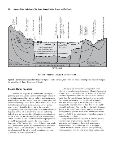
Figure 6. Schematic representation <strong>of</strong> sources <strong>of</strong> ground-water recharge, flow paths, <strong>and</strong> mechanisms <strong>of</strong> ground-water discharge in<br />
<strong>the</strong> upper <strong>Klamath</strong> <strong>Basin</strong>, <strong>Oregon</strong> <strong>and</strong> California.<br />
<strong>Ground</strong>-<strong>Water</strong> Recharge<br />
<strong>Ground</strong> water originates as precipitation. Recharge is<br />
generally greatest in upl<strong>and</strong> areas where <strong>the</strong> largest amount <strong>of</strong><br />
precipitation occurs. The principal recharge areas in <strong>the</strong> upper<br />
<strong>Klamath</strong> <strong>Basin</strong> are <strong>the</strong> Cascade Range <strong>and</strong> upl<strong>and</strong>s within <strong>and</strong><br />
on <strong>the</strong> eastern margin <strong>of</strong> <strong>the</strong> basin. Only a fraction <strong>of</strong> <strong>the</strong> water<br />
that falls as precipitation, however, makes it to <strong>the</strong> groundwater<br />
system. Most ei<strong>the</strong>r is returned to <strong>the</strong> atmosphere<br />
through evaporation from vegetative surfaces <strong>and</strong> transpiration<br />
by plants, or runs <strong>of</strong>f. In areas where soils <strong>and</strong> underlying<br />
bedrock have low permeability, infiltrating precipitation tends<br />
to flow to streams. Such areas typically have well developed<br />
stream networks. In areas where soils <strong>and</strong> underlying bedrock<br />
are highly permeable, for example <strong>the</strong> young volcanic<br />
l<strong>and</strong>scapes <strong>of</strong> <strong>the</strong> Cascade Range, water infiltrates more easily<br />
to <strong>the</strong> ground-water system. Young volcanic areas <strong>of</strong>ten have<br />
poorly developed stream networks as a result. <strong>Water</strong> that<br />
OR19-0048_fig06.ai<br />
percolates through <strong>the</strong> soil to a depth beneath <strong>the</strong> root zone<br />
potentially can become ground water.<br />
Although direct infiltration <strong>of</strong> precipitation is <strong>the</strong><br />
principal source <strong>of</strong> recharge in <strong>the</strong> upper <strong>Klamath</strong> <strong>Basin</strong>, <strong>the</strong>re<br />
are o<strong>the</strong>r sources. Stream leakage can be a source <strong>of</strong> groundwater<br />
recharge in areas where <strong>the</strong> elevation <strong>of</strong> <strong>the</strong> stream is<br />
higher than <strong>the</strong> water table <strong>and</strong> <strong>the</strong> streambed is permeable.<br />
For example, streams that enter <strong>the</strong> <strong>Klamath</strong> Marsh area<br />
from <strong>the</strong> Cascade Range in <strong>the</strong> nor<strong>the</strong>rn part <strong>of</strong> <strong>the</strong> study<br />
area generally lose much or all <strong>of</strong> <strong>the</strong>ir flow into <strong>the</strong> highly<br />
permeable soil as <strong>the</strong>y flow onto <strong>the</strong> pumice plain. No major<br />
streams in <strong>the</strong> upper <strong>Klamath</strong> <strong>Basin</strong>, however, are known to<br />
lose regionally significant water in this manner, <strong>and</strong> stream<br />
leakage probably is not a substantial source <strong>of</strong> recharge on a<br />
regional scale in <strong>the</strong> basin.<br />
Irrigation activities also can result in artificial groundwater<br />
recharge. Irrigation canals typically lose some<br />
water to <strong>the</strong> shallow parts <strong>of</strong> <strong>the</strong> ground-water system.<br />
No measurements <strong>of</strong> canal leakage rates in <strong>the</strong> upper<br />
<strong>Klamath</strong> <strong>Basin</strong> were available or made during this study,<br />
but measurements exist for o<strong>the</strong>r areas. Canal leakage rates


