

Ground-Water Hydrology of the Upper Klamath Basin, Oregon and ...
Ground-Water Hydrology of the Upper Klamath Basin, Oregon and ...
Ground-Water Hydrology of the Upper Klamath Basin, Oregon and ...

Create successful ePaper yourself
Turn your PDF publications into a flip-book with our unique Google optimized e-Paper software.
32 <strong>Ground</strong>-<strong>Water</strong> <strong>Hydrology</strong> <strong>of</strong> <strong>the</strong> <strong>Upper</strong> <strong>Klamath</strong> <strong>Basin</strong>, <strong>Oregon</strong> <strong>and</strong> California<br />
450<br />
300<br />
DISCHARGE, IN CUBIC FEET PER SECOND<br />
400<br />
350<br />
300<br />
250<br />
200<br />
150<br />
100<br />
50<br />
0<br />
1910<br />
1915<br />
1920<br />
1925<br />
1930<br />
1935<br />
1940<br />
1945<br />
1950<br />
1955<br />
Syn<strong>the</strong>tic hydrograph <strong>of</strong> discharge at Dixon Road<br />
Monthly mean flow at Dixon Road (GMA gage)<br />
Instantaneous discharge measurements at Dixon Road<br />
Monthly mean flow at Weed Road (USGS Gage 11504100)<br />
Monthly mean flow at State Hwy 62 (USGS Gage 1504000)<br />
Cumulative departure from precipitation at Crater Lake 1913-2005—<br />
Dotted where estimated from <strong>Klamath</strong> Falls data.<br />
1960<br />
1965<br />
1970<br />
1975<br />
1980<br />
1985<br />
1990<br />
1995<br />
2000<br />
2005<br />
250<br />
200<br />
150<br />
100<br />
50<br />
0<br />
-50<br />
-100<br />
CUMULATIVE DEPARTURE FROM AVERAGE PRECIPITATION, IN INCHES<br />
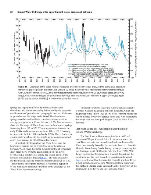
Figure 14. Discharge <strong>of</strong> <strong>the</strong> Wood River as measured or estimated at various sites, <strong>and</strong> <strong>the</strong> cumulative departure<br />
from average precipitation at Crater Lake, <strong>Oregon</strong>. (Monthly mean flow near headwaters from Graham Mat<strong>the</strong>ws,<br />
GMA, written commun. May 13, 2003; flow measurements near headwaters from USGS, various dates, <strong>and</strong> OWRD<br />
unpub. data; estimated discharge at Dixon road derived from regression with Fall River in upper Deschutes <strong>Basin</strong><br />
[USGS gaging station 14057500], a similar size spring-fed stream.)<br />
springs are largely unaffected by tributary inflow <strong>and</strong><br />
diversions, <strong>and</strong> are not noticeably influenced by <strong>the</strong> presently<br />
small amount <strong>of</strong> ground-water pumping in <strong>the</strong> area. Variations<br />
in ground-water discharge to <strong>the</strong> Wood River headwater<br />
springs correlate well with <strong>the</strong> cumulative departure from<br />
average precipitation at Crater Lake (r = 0.75). Measurements<br />
show <strong>the</strong> discharge <strong>of</strong> Wood River near <strong>the</strong> headwaters springs<br />
increasing from 180 to 320 ft 3 /s during wet conditions in <strong>the</strong><br />
early 1980s, <strong>and</strong> <strong>the</strong>n decreasing from 320 to 160 ft 3 /s owing<br />
to drought in <strong>the</strong> late 1980s <strong>and</strong> early 1990s. This reduction in<br />
ground-water discharge to this single spring complex applied<br />
over 1 year equates to 114,000 acre-ft <strong>of</strong> water.<br />
A syn<strong>the</strong>tic hydrograph <strong>of</strong> <strong>the</strong> Wood River near <strong>the</strong><br />
headwaters springs can be created by using <strong>the</strong> relation<br />
between Wood River discharge measurements <strong>and</strong> concurrent<br />
daily mean flows from <strong>the</strong> gaging station on Fall River<br />
(14057500), a similar-scale spring-fed stream about 70 mi<br />
north in <strong>the</strong> Deschutes <strong>Basin</strong> (fig. 14). The relation can be<br />
modeled using a second order polynomial with an R 2 <strong>of</strong> 0.80.<br />
This syn<strong>the</strong>tic hydrograph provides a reasonable depiction<br />
<strong>of</strong> <strong>the</strong> continuous temporal variations in <strong>the</strong> discharge <strong>of</strong> <strong>the</strong><br />
Wood River headwaters springs.<br />
Temporal variations in ground-water discharge directly<br />
to <strong>Upper</strong> <strong>Klamath</strong> Lake have not been measured. Given <strong>the</strong><br />
magnitude <strong>of</strong> <strong>the</strong> inflow (320 to 350 ft 3 /s), temporal variations<br />
can be inferred from o<strong>the</strong>r springs in <strong>the</strong> area with comparable<br />
discharge rates <strong>and</strong> flow-path lengths (such as Wood River<br />
Springs).<br />
Lost River Subbasin—Geographic Distribution <strong>of</strong><br />
<strong>Ground</strong>-<strong>Water</strong> Discharge<br />
The Lost River subbasin occupies about 1,650 mi 2<br />
sou<strong>the</strong>ast <strong>of</strong> <strong>Upper</strong> <strong>Klamath</strong> Lake. In its natural state, <strong>the</strong><br />
Lost River subbasin had no outlet <strong>and</strong> it drained internally.<br />
<strong>Water</strong> occasionally flowed to <strong>the</strong> subbasin, however, from <strong>the</strong><br />
<strong>Klamath</strong> River during floods through a slough connecting <strong>the</strong><br />
two drainages south <strong>of</strong> <strong>Klamath</strong> Falls (La Rue, 1922). With<br />
<strong>the</strong> development <strong>of</strong> Reclamation’s <strong>Klamath</strong> Project <strong>and</strong> <strong>the</strong><br />
construction <strong>of</strong> <strong>the</strong> Lost River diversion dam <strong>and</strong> channel<br />
(fig. 3), controlled flow between <strong>the</strong> <strong>Klamath</strong> <strong>and</strong> Lost Rivers<br />
in both directions now occurs. Major hydrologic features in<br />
this subbasin include Clear Lake <strong>and</strong> Gerber Reservoirs in <strong>the</strong><br />
upl<strong>and</strong>s, <strong>the</strong> Lost River, <strong>and</strong> <strong>the</strong> Tule Lake Sump.<br />
OR19-0048_fig14


