Untitled - Kocaeli BüyükÅehir Belediyesi
Untitled - Kocaeli BüyükÅehir Belediyesi
Untitled - Kocaeli BüyükÅehir Belediyesi

You also want an ePaper? Increase the reach of your titles
YUMPU automatically turns print PDFs into web optimized ePapers that Google loves.
su sesi eflli¤inde yemek yeme imkan› bulabilirsiniz. Kiremitte alabal›k,<br />
f›r›nda mantar ve güveçte köy peyniri Maflukiye’nin özel yemekleri aras›nda<br />
yer almaktad›r.<br />
One of the most famous green places of <strong>Kocaeli</strong> is Maflukiye.<br />
Maflukiye is in 120 kilometers’ distance to ‹stanbul and 20 kilometers’<br />
distance to ‹zmit. Maflukiye where you will reach passing through a road<br />
surrounded by barbecue restaurants and the green nature is covered with<br />
apple, walnut and cherry trees. The name of Maflukiye comes from “mafluk”<br />
which means “lover”. Following the road of Kartepe from Maflukiye, you<br />
can reach the Trout Valley. At both sides of this valley, there are trout<br />
restaurants. You can have a nice lunch or dinner here accompanied by<br />
singing birds and the sound of rushing water from waterfalls. Special<br />
dishes of Maflukiye include trout cooked in kilns, mushroom cooked in<br />
ovens and village cheese cooked in casseroles.<br />
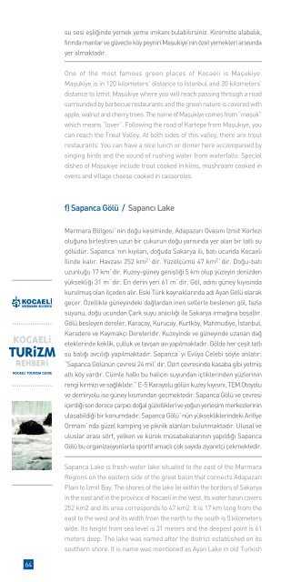
f) Sapanca Gölü / Sapanc› Lake<br />
Marmara Bölgesi`nin do¤u kesiminde, Adapazar› Ovas›n› ‹zmit Körfezi<br />
olu¤una birlefltiren uzun bir çukurun do¤u yar›s›nda yer alan bir tatl› su<br />
gölüdür. Sapanca`n›n k›y›lar›, do¤uda Sakarya ili, bat› ucunda <strong>Kocaeli</strong><br />
‹linde kal›r. Havzas› 252 km 2`dir. Yüzölçümü 47 km 2`dir. Do¤u-bat›<br />
uzunlu¤u 17 km`dir. Kuzey-güney geniflli¤i 5 km olup yüzeyin denizden<br />
yüksekli¤i 31 m`dir. En derin yeri 61 m`dir. Göl, ad›n› güney k›y›s›nda<br />
kurulmufl olan ilçeden al›r. Eski Türk kaynaklar›nda ad› Ayan Gölü olarak<br />
geçer. Özellikle güneyindeki da¤lardan inen sellerle beslenen göl, fazla<br />
suyunu, do¤u ucundan Çark suyu arac›l›¤› ile Sakarya ›rma¤›na boflalt›r.<br />
Gölü besleyen dereler, Karaçay, Kuruçay, Kurtköy, Mahmudiye, ‹stanbul,<br />
Karadere ve Kaymakç› Dereleridir. Kuzeyinde ve güneyinde uzanan da¤<br />
eteklerinde keklik, çulluk ve tavflan av› yap›lmaktad›r. Gölde her çeflit tatl›<br />
su bal›¤› avc›l›¤› yap›lmaktad›r. Sapanca`y› Evliya Çelebi flöyle anlat›r:<br />
“Sapanca Gölünün çevresi 24 mil`dir. Dört çevresinde kasaba gibi yetmifl<br />
alt› köy vard›r. Cümle halk› bu haliçin suyundan içtiklerinden yüzlerinin<br />
rengi k›rm›z› ve sa¤l›kl›d›r.” E-5 Karayolu gölün kuzey k›y›s›n›, TEM Otoyolu<br />
ve demiryolu ise güney k›sm›ndan geçmektedir. Sapanca Gölü ve çevresi<br />
içerdi¤i son derece çarp›c› do¤al güzellikleri ve yo¤un yerleflim merkezlerinin<br />
ulaflabildi¤i bir konumdad›r. Sapanca Gölü`nün yüksekliklerindeki Arifiye<br />
Orman›`nda güzel kamping ve piknik alanlar› bulunmaktad›r. Ulusal ve<br />
uluslar aras› sörf, yelken ve kürek müsabakalar›n›n yap›ld›¤› Sapanca<br />
Gölü bu organizasyonlarla sportif amaçl› çok say›da ziyaretçi çekmektedir.<br />
Sapanca Lake is fresh-water lake situated to the east of the Marmara<br />
Regions on the eastern side of the great basin that connects Adapazar›<br />
Plain to ‹zmit Bay. The shores of the lake lie within the borders of Sakarya<br />
in the east and in the province of <strong>Kocaeli</strong> in the west. Its water basin covers<br />
252 km2 and its area corresponds to 47 km2. It is 17 km long from the<br />
east to the west and its width from the north to the south is 5 kilometers<br />
wide. Its height from sea level is 31 meters and the deepest point is 61<br />
meters deep. The lake was named after the district established on its<br />
southern shore. It is name was mentioned as Ayan Lake in old Turkish<br />
64