Regional Formation 2012,1 - KlaipÄdos universitetas
Regional Formation 2012,1 - KlaipÄdos universitetas
Regional Formation 2012,1 - KlaipÄdos universitetas

You also want an ePaper? Increase the reach of your titles
YUMPU automatically turns print PDFs into web optimized ePapers that Google loves.
Gintarė Pociūtė<br />
THE PROBLEM OF KLAIPĖDA REGION PERIPHERALITY<br />
derstood as the territorial unit, located outside the centre boundary, and related with the centre on the dependence<br />
link, characterized by the lagging behind from the average and lowest geographic, socioeconomic,<br />
demographic, cultural, and political indicators. However, the research in this article excludes some of the aspects<br />
proposed in the definition and takes into account several socio-economic and demographic indicators.<br />
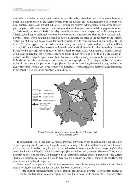
Peripherality is closely linked to centrality researches as these are the two poles of the dichotomy model.<br />
Therefore, working on peripherality evaluation researches it is important to understand how the core-periphery<br />
(CP) model works because this model allows to understand the place of the periphery in the territory<br />
system and at the same time points out the periphery relations with other unites of this system (Fig. 1). The<br />
idea of CP model appeared in the middle of XX century and firstly was produced by J. Friedmann (Friedmann,<br />
1966) and it should be stressed that the model was modified since its first idea. Nowadays scientists<br />
introduce other territorial unites in between of centre and periphery poles. For instance, Z. Norkus (Norkus,<br />
2009) gives an idea that the territorial disparities’ model should have four levels (Fig. 1). The author underlines<br />
that the strongest regions should be called centres that are usually surrounded by peripheries. Thus<br />
Z. Norkus defines these territories around centres as centre-peripheries. According to author, the weakest<br />
regions in the country are pointed out as peripheries. But at the same time, these weakest regions have the<br />
local centres that are more developed territories in the regions. Accordingly, these better developed territories<br />
in peripheral region are named periphery-centres (Fig. 1).<br />
Figure 1. Centre-periphery model (according to Z. Norkus idea)<br />
Source: Norkus, 2009<br />
The model that is developed using Z. Norkus (Norkus, 2009) idea might be adapted for Klaipėda region<br />
as this region is particularly diverse. Klaipėda county has strong centre which is Klaipėda city with the national<br />
level seaport. Also this county has deep peripheral territories that are mostly located in country’s border<br />
zones. Furthermore, Klaipėda region has centre-peripheries and periphery-centres in between. Thus, one of<br />
this article goals’ is to underline the differences in this particular Klaipėda county. The portrait of the current<br />
situation in Klaipėda region would allow to take specific measures in order to improve the conditions for<br />
national and international cooperation.<br />
As the one of the purposes’ of this article is to compare chosen for the survey territories with the Lithuanian<br />
average, the methodology for this survey has been chosen in this way:<br />
• y for the selected socioeconomic indicators’ analysis: the Lithuanian average (LT average) is equated to<br />
100 %, thus this allows to see the regions deviation (negative or positive) from the LT average value;<br />
94