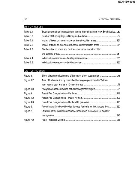
- Page 1 and 2: EXH.160.0001 The Parliament of the
- Page 3 and 4: EXH.160.0003 Contents Foreword.....
- Page 5 and 6: EXH.160.0005 v 5 Management and coo
- Page 7: EXH.160.0007 vii Mr Frank Mossfield
- Page 11 and 12: EXH.160.0011 xi It is my view that
- Page 13 and 14: EXH.160.0013 xiii Committee Secreta
- Page 15 and 16: EXH.160.0015 xv (i) (j) liability,
- Page 17 and 18: EXH.160.0017 xvii EMA Emergency Man
- Page 19 and 20: EXH.160.0019 List of recommendation
- Page 21 and 22: EXH.160.0021 xxi 3 Fuel reduction a
- Page 23 and 24: EXH.160.0023 xxiii Recommendation 2
- Page 25 and 26: EXH.160.0025 xxv Recommendation 28
- Page 27 and 28: EXH.160.0027 xxvii Recommendation 3
- Page 29 and 30: EXH.160.0029 xxix Recommendation 43
- Page 31 and 32: EXH.160.0031 xxxi Having a Bushfir
- Page 33 and 34: EXH.160.0033 The fires in south eas
- Page 35 and 36: EXH.160.0035 2 A NATION CHARRED 1.3
- Page 37 and 38: EXH.160.0037 4 A NATION CHARRED 1.6
- Page 39 and 40: EXH.160.0039 6 A NATION CHARRED 1.1
- Page 41 and 42: EXH.160.0041 8 A NATION CHARRED 1.2
- Page 43 and 44: EXH.160.0043 10 A NATION CHARRED Co
- Page 45 and 46: EXH.160.0045 12 A NATION CHARRED 1.
- Page 47 and 48: EXH.160.0047 14 A NATION CHARRED Fi
- Page 49 and 50: EXH.160.0049 16 A NATION CHARRED 2.
- Page 51 and 52: EXH.160.0051 18 A NATION CHARRED Hi
- Page 53 and 54: EXH.160.0053 20 A NATION CHARRED Th
- Page 55 and 56: EXH.160.0055 22 A NATION CHARRED 2.
- Page 57 and 58: EXH.160.0057 24 A NATION CHARRED 38
- Page 59 and 60:
EXH.160.0059 26 A NATION CHARRED 2.
- Page 61 and 62:
EXH.160.0061 28 A NATION CHARRED 2.
- Page 63 and 64:
EXH.160.0063 30 A NATION CHARRED th
- Page 65 and 66:
EXH.160.0065 32 A NATION CHARRED 2.
- Page 67 and 68:
EXH.160.0067 34 A NATION CHARRED 2.
- Page 69 and 70:
EXH.160.0069 36 A NATION CHARRED 2.
- Page 71 and 72:
EXH.160.0071 38 A NATION CHARRED Re
- Page 73 and 74:
EXH.160.0073 40 A NATION CHARRED Re
- Page 75 and 76:
EXH.160.0075 42 A NATION CHARRED
- Page 77 and 78:
EXH.160.0077 44 A NATION CHARRED 2.
- Page 79 and 80:
EXH.160.0079 46 A NATION CHARRED 2.
- Page 81 and 82:
EXH.160.0081 48 A NATION CHARRED 3.
- Page 83 and 84:
EXH.160.0083 50 A NATION CHARRED 3.
- Page 85 and 86:
EXH.160.0085 52 A NATION CHARRED Ef
- Page 87 and 88:
EXH.160.0087 54 A NATION CHARRED 3.
- Page 89 and 90:
EXH.160.0089 56 A NATION CHARRED ol
- Page 91 and 92:
EXH.160.0091 58 A NATION CHARRED 3.
- Page 93 and 94:
EXH.160.0093 60 A NATION CHARRED 3.
- Page 95 and 96:
EXH.160.0095 62 A NATION CHARRED If
- Page 97 and 98:
EXH.160.0097 64 A NATION CHARRED 3.
- Page 99 and 100:
EXH.160.0099 66 A NATION CHARRED Ef
- Page 101 and 102:
EXH.160.0101 68 A NATION CHARRED 3.
- Page 103 and 104:
EXH.160.0103 70 A NATION CHARRED am
- Page 105 and 106:
EXH.160.0105 72 A NATION CHARRED th
- Page 107 and 108:
EXH.160.0107 74 A NATION CHARRED le
- Page 109 and 110:
EXH.160.0109 76 A NATION CHARRED A
- Page 111 and 112:
EXH.160.0111 78 A NATION CHARRED 3.
- Page 113 and 114:
EXH.160.0113 80 A NATION CHARRED 3.
- Page 115 and 116:
EXH.160.0115 82 A NATION CHARRED 3.
- Page 117 and 118:
EXH.160.0117 84 A NATION CHARRED Ta
- Page 119 and 120:
EXH.160.0119 86 A NATION CHARRED 3.
- Page 121 and 122:
EXH.160.0121 88 A NATION CHARRED bu
- Page 123 and 124:
EXH.160.0123 90 A NATION CHARRED 3.
- Page 125 and 126:
92 A NATION CHARRED EXH.160.0125
- Page 127 and 128:
EXH.160.0127 94 A NATION CHARRED th
- Page 129 and 130:
EXH.160.0129 96 A NATION CHARRED 4.
- Page 131 and 132:
EXH.160.0131 98 A NATION CHARRED 4.
- Page 133 and 134:
EXH.160.0133 100 A NATION CHARRED 4
- Page 135 and 136:
EXH.160.0135 102 A NATION CHARRED c
- Page 137 and 138:
EXH.160.0137 104 A NATION CHARRED P
- Page 139 and 140:
EXH.160.0139 106 A NATION CHARRED I
- Page 141 and 142:
EXH.160.0141 108 A NATION CHARRED 4
- Page 143 and 144:
EXH.160.0143 110 A NATION CHARRED W
- Page 145 and 146:
EXH.160.0145 112 A NATION CHARRED 4
- Page 147 and 148:
EXH.160.0147 114 A NATION CHARRED 4
- Page 149 and 150:
EXH.160.0149 116 A NATION CHARRED I
- Page 151 and 152:
EXH.160.0151 118 A NATION CHARRED 4
- Page 153 and 154:
EXH.160.0153 120 A NATION CHARRED 4
- Page 155:
EXH.160.0155 122 A NATION CHARRED U
- Page 158 and 159:
EXH.160.0158 THE APPROACH TO THE 20
- Page 160 and 161:
EXH.160.0160 THE APPROACH TO THE 20
- Page 162 and 163:
EXH.160.0162 THE APPROACH TO THE 20
- Page 164 and 165:
EXH.160.0164 THE APPROACH TO THE 20
- Page 166 and 167:
EXH.160.0166 THE APPROACH TO THE 20
- Page 168 and 169:
EXH.160.0168 THE APPROACH TO THE 20
- Page 170 and 171:
EXH.160.0170 THE APPROACH TO THE 20
- Page 172 and 173:
EXH.160.0172 THE APPROACH TO THE 20
- Page 174 and 175:
EXH.160.0174 THE APPROACH TO THE 20
- Page 176 and 177:
and coordination of fire Management
- Page 178 and 179:
EXH.160.0178 MANAGEMENT AND COORDIN
- Page 180 and 181:
EXH.160.0180 MANAGEMENT AND COORDIN
- Page 182 and 183:
EXH.160.0182 MANAGEMENT AND COORDIN
- Page 184 and 185:
EXH.160.0184 MANAGEMENT AND COORDIN
- Page 186 and 187:
EXH.160.0186 MANAGEMENT AND COORDIN
- Page 188 and 189:
EXH.160.0188 MANAGEMENT AND COORDIN
- Page 190 and 191:
EXH.160.0190 MANAGEMENT AND COORDIN
- Page 192 and 193:
EXH.160.0192 MANAGEMENT AND COORDIN
- Page 194 and 195:
EXH.160.0194 MANAGEMENT AND COORDIN
- Page 196 and 197:
EXH.160.0196 MANAGEMENT AND COORDIN
- Page 198 and 199:
EXH.160.0198 MANAGEMENT AND COORDIN
- Page 200 and 201:
EXH.160.0200 MANAGEMENT AND COORDIN
- Page 202 and 203:
EXH.160.0202 MANAGEMENT AND COORDIN
- Page 204 and 205:
EXH.160.0204 MANAGEMENT AND COORDIN
- Page 206 and 207:
EXH.160.0206 MANAGEMENT AND COORDIN
- Page 208 and 209:
EXH.160.0208 MANAGEMENT AND COORDIN
- Page 210 and 211:
EXH.160.0210 MANAGEMENT AND COORDIN
- Page 212 and 213:
EXH.160.0212 MANAGEMENT AND COORDIN
- Page 214 and 215:
EXH.160.0214 MANAGEMENT AND COORDIN
- Page 216 and 217:
EXH.160.0216 MANAGEMENT AND COORDIN
- Page 218 and 219:
EXH.160.0218 MANAGEMENT AND COORDIN
- Page 220 and 221:
EXH.160.0220 6 Fire fighting resour
- Page 222 and 223:
EXH.160.0222 FIRE FIGHTING RESOURCE
- Page 224 and 225:
EXH.160.0224 FIRE FIGHTING RESOURCE
- Page 226 and 227:
EXH.160.0226 FIRE FIGHTING RESOURCE
- Page 228 and 229:
EXH.160.0228 FIRE FIGHTING RESOURCE
- Page 230 and 231:
EXH.160.0230 FIRE FIGHTING RESOURCE
- Page 232 and 233:
EXH.160.0232 FIRE FIGHTING RESOURCE
- Page 234 and 235:
EXH.160.0234 FIRE FIGHTING RESOURCE
- Page 236 and 237:
EXH.160.0236 FIRE FIGHTING RESOURCE
- Page 238 and 239:
EXH.160.0238 FIRE FIGHTING RESOURCE
- Page 240 and 241:
EXH.160.0240 FIRE FIGHTING RESOURCE
- Page 242 and 243:
EXH.160.0242 FIRE FIGHTING RESOURCE
- Page 244 and 245:
EXH.160.0244 FIRE FIGHTING RESOURCE
- Page 246 and 247:
EXH.160.0246 FIRE FIGHTING RESOURCE
- Page 248 and 249:
EXH.160.0248 FIRE FIGHTING RESOURCE
- Page 250 and 251:
EXH.160.0250 FIRE FIGHTING RESOURCE
- Page 252 and 253:
EXH.160.0252 FIRE FIGHTING RESOURCE
- Page 254 and 255:
EXH.160.0254 FIRE FIGHTING RESOURCE
- Page 256 and 257:
EXH.160.0256 FIRE FIGHTING RESOURCE
- Page 258 and 259:
EXH.160.0258 FIRE FIGHTING RESOURCE
- Page 260 and 261:
EXH.160.0260 FIRE FIGHTING RESOURCE
- Page 262 and 263:
EXH.160.0262 FIRE FIGHTING RESOURCE
- Page 264 and 265:
EXH.160.0264 FIRE FIGHTING RESOURCE
- Page 266 and 267:
EXH.160.0266 FIRE FIGHTING RESOURCE
- Page 268 and 269:
EXH.160.0268 FIRE FIGHTING RESOURCE
- Page 270 and 271:
EXH.160.0270 FIRE FIGHTING RESOURCE
- Page 272 and 273:
EXH.160.0272 FIRE FIGHTING RESOURCE
- Page 274 and 275:
EXH.160.0274 FIRE FIGHTING RESOURCE
- Page 276 and 277:
EXH.160.0276 FIRE FIGHTING RESOURCE
- Page 278 and 279:
EXH.160.0278 7 Fire protection 7.1
- Page 280 and 281:
EXH.160.0280 FIRE PROTECTION 247 Fi
- Page 282 and 283:
EXH.160.0282 FIRE PROTECTION 249 Co
- Page 284 and 285:
EXH.160.0284 FIRE PROTECTION 251 Ta
- Page 286 and 287:
EXH.160.0286 FIRE PROTECTION 253 7.
- Page 288 and 289:
EXH.160.0288 FIRE PROTECTION 255 Bu
- Page 290 and 291:
EXH.160.0290 FIRE PROTECTION 257 as
- Page 292 and 293:
EXH.160.0292 FIRE PROTECTION 259 7.
- Page 294 and 295:
EXH.160.0294 FIRE PROTECTION 261 Ta
- Page 296 and 297:
EXH.160.0296 FIRE PROTECTION 263 Pl
- Page 298 and 299:
EXH.160.0298 FIRE PROTECTION 265 7.
- Page 300 and 301:
EXH.160.0300 FIRE PROTECTION 267 th
- Page 302 and 303:
EXH.160.0302 FIRE PROTECTION 269 7.
- Page 304 and 305:
EXH.160.0304 FIRE PROTECTION 271 7.
- Page 306 and 307:
EXH.160.0306 FIRE PROTECTION 273 co
- Page 308 and 309:
EXH.160.0308 FIRE PROTECTION 275 Re
- Page 310 and 311:
EXH.160.0310 FIRE PROTECTION 277 7.
- Page 312 and 313:
EXH.160.0312 FIRE PROTECTION 279 7.
- Page 314 and 315:
EXH.160.0314 FIRE PROTECTION 281 7.
- Page 316 and 317:
directions for the Commonwealth: Fu
- Page 318 and 319:
EXH.160.0318 FUTURE DIRECTIONS FOR
- Page 320 and 321:
EXH.160.0320 FUTURE DIRECTIONS FOR
- Page 322 and 323:
eport Dissenting Mr Michael Organ M
- Page 324 and 325:
EXH.160.0324 DISSENT ON THE REPORT
- Page 326 and 327:
EXH.160.0326 important that the RFS
- Page 328 and 329:
EXH.160.0328 The management of bush
- Page 330:
EXH.160.0330 It highlights the fact
- Page 333 and 334:
EXH.160.0333 As well as the need to
- Page 335 and 336:
EXH.160.0335 conservation purpose.
- Page 337 and 338:
EXH.160.0337 not sufficient evidenc
- Page 339 and 340:
EXH.160.0339 regime. This represent
- Page 341 and 342:
EXH.160.0341 I do know…that we ar
- Page 343 and 344:
EXH.160.0343 are not supported by a
- Page 345 and 346:
EXH.160.0345 The World Conservation
- Page 347 and 348:
EXH.160.0347 Recommendation 6 That
- Page 349 and 350:
316 A NATION CHARRED EXH.160.0349
- Page 351 and 352:
EXH.160.0351 Overview The context i
- Page 353 and 354:
EXH.160.0353 to apportion blame. Th
- Page 355 and 356:
EXH.160.0355 We are of the view tha
- Page 357 and 358:
EXH.160.0357 could have been amelio
- Page 359 and 360:
EXH.160.0359 There is an urgent nee
- Page 361 and 362:
EXH.160.0361 328 A NATION CHARRED d
- Page 363 and 364:
EXH.160.0363 330 A NATION CHARRED f
- Page 365 and 366:
EXH.160.0365 332 A NATION CHARRED A
- Page 367 and 368:
EXH.160.0367 334 A NATION CHARRED 2
- Page 369 and 370:
EXH.160.0369 336 A NATION CHARRED 9
- Page 371 and 372:
EXH.160.0371 338 A NATION CHARRED 1
- Page 373 and 374:
EXH.160.0373 340 A NATION CHARRED 2
- Page 375 and 376:
EXH.160.0375 342 A NATION CHARRED 2
- Page 377 and 378:
EXH.160.0377 344 A NATION CHARRED 3
- Page 379 and 380:
EXH.160.0379 346 A NATION CHARRED 4
- Page 381 and 382:
EXH.160.0381 348 A NATION CHARRED 4
- Page 383 and 384:
EXH.160.0383 350 A NATION CHARRED 8
- Page 385 and 386:
EXH.160.0385 352 A NATION CHARRED 2
- Page 387 and 388:
EXH.160.0387 354 A NATION CHARRED 4
- Page 389 and 390:
EXH.160.0389 356 A NATION CHARRED W
- Page 391 and 392:
EXH.160.0391 358 A NATION CHARRED P
- Page 393 and 394:
EXH.160.0393 360 A NATION CHARRED B
- Page 395 and 396:
EXH.160.0395 362 A NATION CHARRED M
- Page 397 and 398:
EXH.160.0397 364 A NATION CHARRED V
- Page 399 and 400:
EXH.160.0399 366 A NATION CHARRED S
- Page 401 and 402:
368 A NATION CHARRED EXH.160.0401
- Page 403 and 404:
370 A NATION CHARRED EXH.160.0403
- Page 405 and 406:
eport is dedicated to three people
- Page 407 and 408:
House of Representatives Select Com
- Page 409 and 410:
more unified and co-operative appro
- Page 411 and 412:
most recent fire season was therefo
- Page 413 and 414:
3. Fuel Build-Up Curves of Main Veg
- Page 415 and 416:
4. Frequency of Days with Soil Dryn
- Page 417 and 418:
1. Summary Records of Peak Fire Dan
- Page 419 and 420:
about the 1 st February onwards the
- Page 421 and 422:
enable a scientific analysis of pot
- Page 423 and 424:
assignment was based on the author
- Page 425 and 426:
detail in Table 2 provides strategi
- Page 427 and 428:
Day Burning Parameter of Years No R
- Page 429 and 430:
y Tolhurst (2003), and may yield be
- Page 431 and 432:
of the lower Cotter catchment and M
- Page 433 and 434:
of the submissions from the High Co
- Page 435 and 436:
5-10 years after a fire. There is a
- Page 437 and 438:
author has had considerable experie
- Page 439 and 440:
The risk of multiple lightning stri
- Page 441 and 442:
K. (1993). Prescribed Burning in Pr
- Page 443 and 444:
Figure 1b Historical Trends in Soil
- Page 445 and 446:
TABLE 6. STATISTICS OF POTENTIAL FU
- Page 447 and 448:
414 A NATION CHARRED EXH.160.0447
- Page 449 and 450:
EXH.160.0449 Table of Contents GLOS
- Page 451 and 452:
EXH.160.0451 1. Executive Summary O
- Page 453 and 454:
EXH.160.0453 report, because matchi
- Page 455 and 456:
EXH.160.0455 2. Project Overview Th
- Page 457 and 458:
EXH.160.0457 the brief some other i
- Page 459 and 460:
EXH.160.0459 Portable repeaters are
- Page 461 and 462:
EXH.160.0461 view is that the Commo
- Page 463 and 464:
EXH.160.0463 (FESA) and the Bush Fi
- Page 465 and 466:
EXH.160.0465 responsibilities of th
- Page 467 and 468:
EXH.160.0467 The callout of the bri
- Page 469 and 470:
EXH.160.0469 communication, but wit
- Page 471 and 472:
EXH.160.0471 planning for the use o
- Page 473 and 474:
EXH.160.0473 of each. In such situa
- Page 475 and 476:
EXH.160.0475 Support for the retent
- Page 477 and 478:
EXH.160.0477 overcome the black spo
- Page 479 and 480:
EXH.160.0479 This subject presented
- Page 481 and 482:
EXH.160.0481 controlled by either b
- Page 483 and 484:
EXH.160.0483 There can be little do
- Page 485 and 486:
EXH.160.0485 locations of fires and
- Page 487 and 488:
EXH.160.0487 and modified to meet t
- Page 489 and 490:
EXH.160.0489 in conjunction with HF
- Page 491 and 492:
EXH.160.0491 VHF band, the deficien
- Page 493 and 494:
EXH.160.0493 In discussions with th
- Page 495 and 496:
EXH.160.0495 The following Diagrams
- Page 497 and 498:
EXH.160.0497 Air Operations Communi
- Page 499 and 500:
EXH.160.0499 PREPARED BY:__________


