Ayr Central Conservation Area Character Appraisal - South Ayrshire ...
Ayr Central Conservation Area Character Appraisal - South Ayrshire ...
Ayr Central Conservation Area Character Appraisal - South Ayrshire ...

You also want an ePaper? Increase the reach of your titles
YUMPU automatically turns print PDFs into web optimized ePapers that Google loves.
<strong>Ayr</strong> <strong>Central</strong> <strong>Conservation</strong> <strong>Area</strong> <strong>Character</strong> <strong>Appraisal</strong><br />
Part One<br />
Included: starting at the southern end of the New<br />
Bridge, and moving in a clockwise direction, the<br />
conservation area boundary runs as follows: along the<br />
south bank of the River <strong>Ayr</strong> to the south-east corner<br />
of the Parish Kirkyard; along the southern boundary<br />
of the Kirkyard, then south along the western side of<br />
Mill Wynd and behind the eastern side of Kyle Street;<br />
at Smith Street the boundary follows the building line<br />
along the northern side of the road and around the north<br />
side of Burns Statue Square; at the south-east end of<br />
Dablair Road the boundary runs behind the buildings<br />
fronting the west side of Burns Statute Square, then<br />
behind the south side of Miller Road (where it forms<br />
a mutual boundary with <strong>Ayr</strong> 2 <strong>Conservation</strong> <strong>Area</strong>); at<br />
Racecourse Road it runs north along the east side of the<br />
road, then along the northern boundary of the Fairfield<br />
Street properties to Low Green; the boundary follows<br />
the eastern edge of Low Green to Wellington Square,<br />
then westwards along the south side of Pavilion Road<br />
before heading north immediately behind the Council<br />
offices to Bath Place; from the south side of Bath Place<br />
the boundary runs along the rear of the properties on<br />
the west side of Queen’s Terrace to Cromwell Road<br />
and along the line of the Citadel Wall to Miller’s Folly;<br />
from Miller’s Folly the boundary runs along the south<br />
side of <strong>South</strong> Harbour Street back to the south end of<br />
the New Bridge.<br />
Excluded: starting at the north-east property boundary<br />
of 43 Sandgate, the boundary of the ‘excluded zone’<br />
runs as follows: along the rear of the Newmarket<br />
Street and High Street rigs then behind 85–49 Dalblair<br />
Road; from there the boundary crosses to the south<br />
side of Dalblair Road and behind the properties on the<br />
west side of Dalblair Road and Homebriar House, to<br />
Fullarton Street; the boundary passes along the north<br />
side of Fullarton Street behind Holy Trinity Church and<br />
continues past the Bus Station to the east side of Fort<br />
Street; from the south-west corner of 54 Fort Street<br />
the boundary runs behind the properties at 100–60<br />
Sandgate before crossing to the east side of Sandgate<br />
at the Post Office, and back to 43 Sandgate.<br />
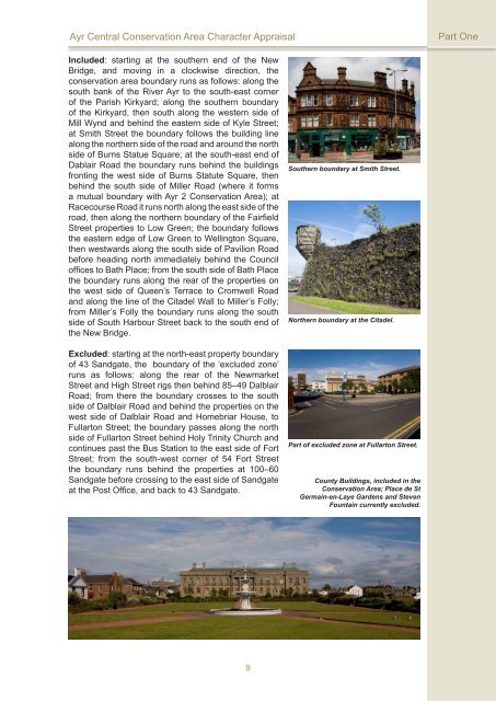
<strong>South</strong>ern boundary at Smith Street.<br />
Northern boundary at the Citadel.<br />
Part of excluded zone at Fullarton Street.<br />
County Buildings, included in the<br />
<strong>Conservation</strong> <strong>Area</strong>; Place de St<br />
Germain-en-Laye Gardens and Steven<br />
Fountain currently excluded.<br />
9